

ATL: EMILY - Remnants
Moderator: S2k Moderators
-
stormreader
Re: ATL: EMILY - Remnants - Discussion
Question: The NHC does have the red shading to include the area south of eastern Cuba along with the Bahamas to the north. If development would occur there what would it mean in terms of track and forecast movement?? Would it still mean that we could expect the system to eventually move north across Cuba with a coming weakness pulling it up, or could we expect a more westerly component?
0 likes
-
stormreader
Re: ATL: EMILY - Remnants - Discussion
Okay I guess I misunderstood you NDG. I thought you were implying that the south coast of Cuba (surface trough) had the greatest potential for development. But no?? You also think that in the coming day or so, it will be the seas of north of Cuba where we can expect development??
0 likes
-
Miami Storm Tracker

- Category 4

- Posts: 916
- Age: 68
- Joined: Sun Jun 13, 2010 10:12 pm
- Location: Key Largo, Fla.
- Contact:
Re: ATL: Ex EMILY - Models
blp wrote:Miami Storm Tracker wrote:blp wrote:If it means anything the GFS is bringing Emily back starting at 30hr on the 18z.
http://www.nco.ncep.noaa.gov/pmb/nwprod/analysis/carib/gfs/18/images/gfs_ten_030l.gif
My friend as much as I consider you a very good friend give it up. I am with you but it's just not going to happen.
Yea, but there is nothing else out there at the moment. It is hard to let go sometimes especially after reading some 200+ pages of posts.
I know that why I am as bad as you are still reading all these post, and even still wondering just maybe it might happen.
0 likes
-
wxman57

- Moderator-Pro Met

- Posts: 23175
- Age: 68
- Joined: Sat Jun 21, 2003 8:06 pm
- Location: Houston, TX (southwest)
Re: ATL: EMILY - Remnants - Discussion
Moderate shear + no low-level convergence = no redevelopment.
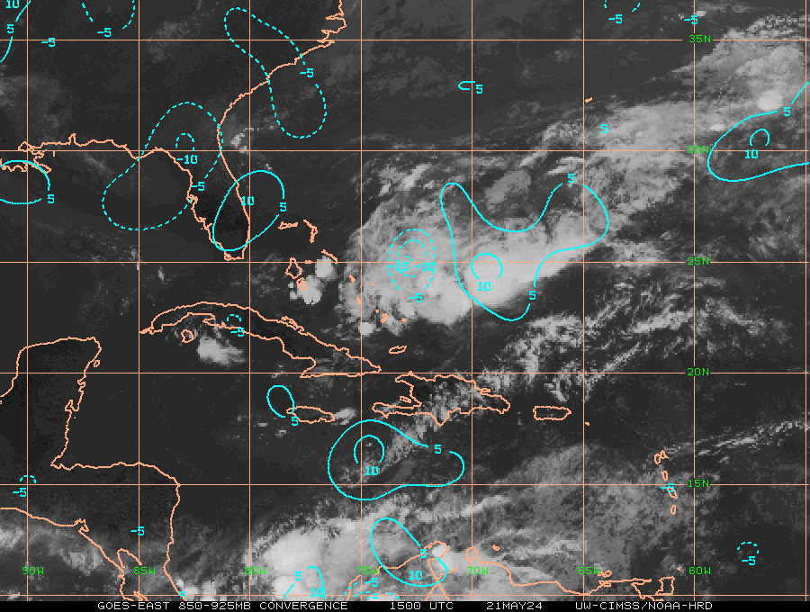
I can see a bit of a swirl up around 22.5N/77W, but all storms have been ripped away well to the east. No sign of the shear letting up.
I can see a bit of a swirl up around 22.5N/77W, but all storms have been ripped away well to the east. No sign of the shear letting up.
0 likes
-
stormreader
Re: ATL: EMILY - Remnants - Discussion
wxman57 wrote:Moderate shear + no low-level convergence = no redevelopment.
I can see a bit of a swirl up around 22.5N/77W, but all storms have been ripped away well to the east. No sign of the shear letting up.
Wxman--what do you make of the 60% chance for redevelopment given by the NHC?
0 likes
The more I look at that area the more I think they placed the best track position in the middle of two potential areas for cyclogenesis, I think just a little east has the best potential, I see some convergence trying to get going just SW of Crooked & Acklins Islands in the Bahamas near 22 N & 76 W.
0 likes
-
wxman57
- Moderator-Pro Met
- Posts: 23175
- Age: 68
- Joined: Sat Jun 21, 2003 8:06 pm
- Location: Houston, TX (southwest)
Re: ATL: EMILY - Remnants - Discussion
stormreader wrote:wxman57 wrote:Moderate shear + no low-level convergence = no redevelopment.
I can see a bit of a swirl up around 22.5N/77W, but all storms have been ripped away well to the east. No sign of the shear letting up.
Wxman--what do you make of the 60% chance for redevelopment given by the NHC?
Part Stacey Stewart's higher estimate from last evening, part Beven and Avila keeping continuity in subsequent shifts, and part the NHC's thinking that it's not a bad idea for folks in the Bahamas & Florida to continue to keep an eye on it. I don't think they really think that any redevelopment is imminent.
0 likes
-
Jevo

- S2K Supporter

- Posts: 1729
- Age: 47
- Joined: Tue Aug 03, 2004 8:45 pm
- Location: The Flemish Cap
- Contact:
Re: ATL: EMILY - Remnants - Discussion
Nothing like a blob watch to make a Friday at work go by faster....
What a different thread this would be if the blob was brand new and there was a 60% on it. This place would be going Ape..
What a different thread this would be if the blob was brand new and there was a 60% on it. This place would be going Ape..
0 likes
Disclaimer: 50% of the time I have no clue of what I am talking about. Chances are I am taking a less than educated guess that sounds good because 10 years ago I stole Mike Watkins book 'The Hurricane and its Impact'. For official information please direct yourself to the NHC and their cadre of weather geniuses.
Re: ATL: EMILY - Remnants - Discussion
It is 48 hours on that 60%, tomorrow the conditions could be better. That is when the GFS does something with it.
0 likes

Re: ATL: EMILY - Remnants - Discussion
Jevo wrote:Nothing like a blob watch to make a Friday at work go by faster....
What a different thread this would be if the blob was brand new and there was a 60% on it. This place would be going Ape..
Blob watching mode is engaged.
0 likes
The preceding comments are never to be used as information to establish circumstances, plans or procedures for any weather related events. Only use official National Hurricane Center or National Weather Service information issued for your area.
-
ozonepete
- Professional-Met

- Posts: 4743
- Joined: Mon Sep 07, 2009 3:23 pm
- Location: From Ozone Park, NYC / Now in Brooklyn, NY
Re: ATL: EMILY - Remnants - Discussion
This looks the most likely spot to me. And it matches the convergence area on the CIMSS chart someone posted recently.
0 likes
-
HurricaneBelle

- S2K Supporter
- Posts: 1209
- Joined: Sun Aug 27, 2006 6:12 pm
- Location: Clearwater, FL
-
ozonepete
- Professional-Met
- Posts: 4743
- Joined: Mon Sep 07, 2009 3:23 pm
- Location: From Ozone Park, NYC / Now in Brooklyn, NY
Re: ATL: EMILY - Remnants - Discussion
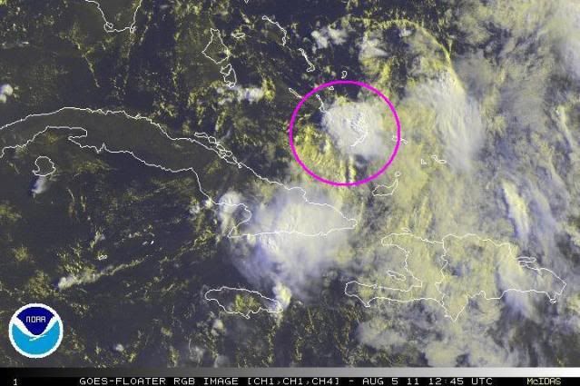
Here's the other area where there is clearly rotation going on.

0 likes
Re:
NDG wrote:They are going to be starting the tropical models closer to the surface trough than by the mid level vorticity. It will interesting.
AL, 05, 2011080512, , BEST, 0, 220N, 765W,
Where can I find this information? I would like to read up on it
0 likes
CARTERET COUNTY NC


Re:
HurricaneBelle wrote:Shouldn't this still be on the Storm2K map? It's the equivalent of an invest, since it's being outlooked and the tropical models are still running for it.
my understanding is the map is automatically updated by NHC data, in other words s2k doesn't really do it themselves.
0 likes
-
amawea

- S2K Supporter
- Posts: 385
- Age: 74
- Joined: Mon Aug 09, 2004 3:36 pm
- Location: Horseshoe Bend, Ar. but from Baytown, Tx
Re: ATL: EMILY - Remnants - Discussion
I agree with you too NDG: looks like ozonepete does too. 
0 likes
-
flashflood

- Tropical Storm

- Posts: 187
- Joined: Tue Nov 09, 2004 12:30 pm
- Location: S. FL
Re: ATL: EMILY - Remnants - Discussion
Jevo wrote:Nothing like a blob watch to make a Friday at work go by faster....
What a different thread this would be if the blob was brand new and there was a 60% on it. This place would be going Ape..
That's for sure on both parts
Would be nice if a blob came into radar range late this afternoon to watch as well. There seems to be dry air to the NW of the area of slight turning N. of Cuba, however I see some convection here and there in throughout that area so it not too dry to support a blob for now.
0 likes
Who is online
Users browsing this forum: No registered users and 54 guests