
cycloneye wrote:18z Best Track
AL, 05, 2011080518, , BEST, 0, 230N, 780W, 30, 1011, WV
Luis,
exactly where long range MIA indicates..just sw of andros
Moderator: S2k Moderators
cycloneye wrote:18z Best Track
AL, 05, 2011080518, , BEST, 0, 230N, 780W, 30, 1011, WV


Code: Select all
WHXX01 KWBC 051823
CHGHUR
TROPICAL CYCLONE GUIDANCE MESSAGE
NWS NATIONAL HURRICANE CENTER MIAMI FL
1823 UTC FRI AUG 5 2011

DISCLAIMER...NUMERICAL MODELS ARE SUBJECT TO LARGE ERRORS.
PLEASE REFER TO NHC OFFICIAL FORECASTS FOR TROPICAL CYCLONE
AND SUBTROPICAL CYCLONE INFORMATION.

ATLANTIC OBJECTIVE AIDS FOR

DISTURBANCE EMILY (AL052011) 20110805 1800 UTC

        ...00 HRS...   ...12 HRS...   ...24 HRS. ..   ...36 HRS...
        110805  1800   110806  0600   110806  1800   110807  0600

         LAT    LON     LAT    LON     LAT    LON     LAT    LON
BAMS    23.0N  78.0W   24.3N  79.5W   25.8N  80.7W   26.8N  81.3W
BAMD    23.0N  78.0W   23.9N  79.6W   24.8N  81.2W   25.7N  82.6W
BAMM    23.0N  78.0W   24.0N  79.6W   25.0N  80.9W   25.9N  81.8W
LBAR    23.0N  78.0W   24.4N  79.9W   25.8N  81.6W   27.1N  82.7W
SHIP        30KTS          32KTS          35KTS          38KTS
DSHP        30KTS          32KTS          35KTS          38KTS

        ...48 HRS...   ...72 HRS...   ...96 HRS. ..   ..120 HRS...
        110807  1800   110808  1800   110809  1800   110810  1800

         LAT    LON     LAT    LON     LAT    LON     LAT    LON
BAMS    28.0N  81.1W   29.6N  77.2W   31.8N  70.3W   33.8N  60.0W
BAMD    26.4N  83.5W   27.5N  84.4W   28.3N  83.6W   28.5N  80.0W
BAMM    26.7N  82.3W   27.7N  81.7W   28.3N  79.3W   29.6N  74.9W
LBAR    28.2N  83.0W   29.8N  81.9W   30.6N  78.1W   32.5N  72.1W
SHIP        40KTS          46KTS          51KTS          36KTS
DSHP        40KTS          46KTS          51KTS          36KTS

         ...INITIAL CONDITIONS...
LATCUR =  23.0N LONCUR =  78.0W DIRCUR = 310DEG SPDCUR =  15KT
LATM12 =  20.9N LONM12 =  74.5W DIRM12 = 310DEG SPDM12 =  17KT
LATM24 =  18.1N LONM24 =  73.3W
WNDCUR =   30KT RMAXWD =   60NM WNDM12 =   25KT
CENPRS = 1011MB OUTPRS = 1014MB OUTRAD =  100NM SDEPTH =   S
RD34NE =    0NM RD34SE =    0NM RD34SW =    0NM RD34NW =   0NM

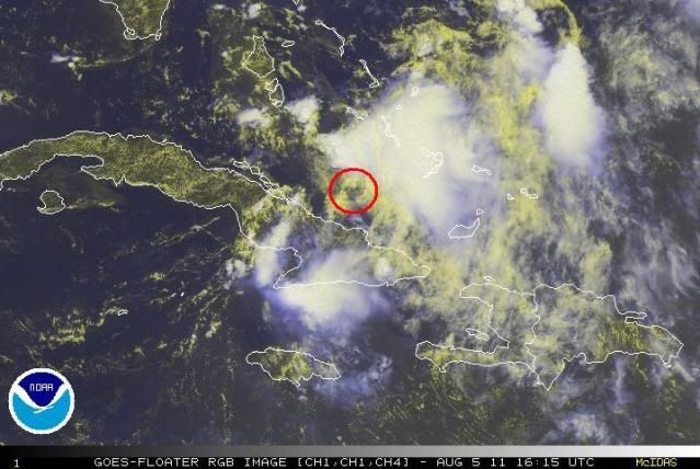
The one around 23.3N 78.5 is the one MIA radar is picking up. Thoughts?
cycloneye wrote:The one around 23.3N 78.5 is the one MIA radar is picking up. Thoughts?
23.0N-78.0W per 18z Best Track. Pretty close your view of low.
Are they still running them for Emily's carcass?


wxman57 wrote:Surface obs don't indicate anything near 22N/76W, just SE flow and 1014-1015MB pressure there. Obs do indicate a trof axis along about 78.3W with a weak lower-level rotation near 23N. In 24 hours this will already be past SE Florida, turning north, then heading NE and out to sea. No significant threat to Florida. Possibly a few daytime thunderstorms tomorrow as it passes. I don't see any sign of it becoming better organized at present. Shear is still there.


Yikes. What will that do to the models? Are they still running them for Emily's carcass?
cycloneye wrote:Are they still running them for Emily's carcass?
I posted the 18z models at the thread for that.

gatorcane wrote:Click the link below and then click on the FRONTS tab. You can see where the low is located.
I can also see clouds quicks blowing off of cuba and getting sucked into where that Low is located (inflow).
Lots of convection now starting to surround that area of lower pressure.
There is something going on there. If trends continue I can see this up to 80%+ by next TWO:
http://www.ssd.noaa.gov/goes/flt/t2/loop-vis.html
Users browsing this forum: No registered users and 111 guests


