ATL: NATE - Remnants - Discussion
Moderator: S2k Moderators
-
South Texas Storms

- Professional-Met

- Posts: 4256
- Joined: Thu Jun 24, 2010 12:28 am
- Location: Houston, TX
Re: ATL: NATE - Models
18z GFS shifted much further south. Might not even get up to central MX on this run.
0 likes
-
Jevo

- S2K Supporter

- Posts: 1729
- Age: 47
- Joined: Tue Aug 03, 2004 8:45 pm
- Location: The Flemish Cap
- Contact:
18Z gfs +72

0 likes
Disclaimer: 50% of the time I have no clue of what I am talking about. Chances are I am taking a less than educated guess that sounds good because 10 years ago I stole Mike Watkins book 'The Hurricane and its Impact'. For official information please direct yourself to the NHC and their cadre of weather geniuses.
-
Jevo
- S2K Supporter
- Posts: 1729
- Age: 47
- Joined: Tue Aug 03, 2004 8:45 pm
- Location: The Flemish Cap
- Contact:
18Z gfs +84 (Into Mexico) 
Gone @ +96

Gone @ +96
0 likes
Disclaimer: 50% of the time I have no clue of what I am talking about. Chances are I am taking a less than educated guess that sounds good because 10 years ago I stole Mike Watkins book 'The Hurricane and its Impact'. For official information please direct yourself to the NHC and their cadre of weather geniuses.
-
SunnyThoughts
- Category 5

- Posts: 2263
- Joined: Wed Jul 09, 2003 12:42 pm
- Location: Pensacola, Florida
Re: ATL: NATE - Tropical Storm - Discussion
tobol.7uno wrote:Cranica wrote:Rock, if you haven't seen it, you should check out Jeff Masters' account of his flight into Hurricane Hugo.
I have read that. Sounds like fun! While of course extremely scary. I am glad they all made it out alive. Has there ever been any fatalities on hurricane hunter planes?
The only Atlantic Hurricane Hunter flight to go down occurred on September 26, 1955. Snowcloud Five, a U.S. Navy P2V Neptune weather reconnaissance airplane flying out of Guantanamo, Cuba, was lost in Hurricane Janet, 300 miles southwest of Jamaica. Snowcloud Five was part of the Airborne Early Warning Squadron Four (VW-4), based at the Jacksonville, Florida Naval Air Station. Carrying a crew of nine and two reporters from the Toronto Daily Star, Snowcloud Five took off at 0630 local time, and performed its initial penetration into Janet at an altitude of 700 feet. At the time of the crash, Janet was a Category 4 hurricane with 145 mph winds. The aircraft sent back this transmission, then was never heard from again:
LINK TO ARTICLE: http://www.wunderground.com/hurricane/hunter4.asp
0 likes

Well NHC now forecasting Nate to reach category-2, hard to ignore that possiblity given its not that far from being a hurricane right now!
0 likes
Personal Forecast Disclaimer:
The posts in this forum are NOT official forecast and should not be used as such. They are just the opinion of the poster and may or may not be backed by sound meteorological data. They are NOT endorsed by any professional institution or storm2k.org. For official information, please refer to the NHC and NWS products
The posts in this forum are NOT official forecast and should not be used as such. They are just the opinion of the poster and may or may not be backed by sound meteorological data. They are NOT endorsed by any professional institution or storm2k.org. For official information, please refer to the NHC and NWS products
-
Dave

- Retired Staff

- Posts: 13442
- Age: 75
- Joined: Tue Aug 01, 2006 3:57 pm
- Location: Milan Indiana
- Contact:
Nothing in since hdobs 34 from earlier so here's the next mission for tonight/early morning:
FLIGHT THREE -- TEAL 77....(ADDED)
A. 09/0600Z
B. AFXXX 0415A NATE
C. 09/0330Z
D. 20.4N 92.1W
E. 09/0530Z TO 09/1000Z
F. SFC TO 10,000 FT
FLIGHT THREE -- TEAL 77....(ADDED)
A. 09/0600Z
B. AFXXX 0415A NATE
C. 09/0330Z
D. 20.4N 92.1W
E. 09/0530Z TO 09/1000Z
F. SFC TO 10,000 FT
0 likes
This post is NOT AN OFFICIAL FORECAST and should not be used as such. It is just the opinion of the poster and may or may not be backed by sound meteorological data. It is NOT endorsed by any professional institution including storm2k.org. For Official Information please refer to the NHC and NWS products.
-
HurricaneRobert
- Category 3

- Posts: 812
- Joined: Fri May 18, 2007 9:31 pm
-
HouTXmetro

- Category 5
- Posts: 3949
- Joined: Sun Jun 13, 2004 6:00 pm
- Location: District of Columbia, USA
-
tropicwatch

- Category 5
- Posts: 3426
- Age: 62
- Joined: Sat Jun 02, 2007 10:01 am
- Location: The Villages, Florida
- Contact:
-
Jevo
- S2K Supporter
- Posts: 1729
- Age: 47
- Joined: Tue Aug 03, 2004 8:45 pm
- Location: The Flemish Cap
- Contact:
Re: Re:
panamatropicwatch wrote:Jevo wrote:18Z gfs +84 (Into Mexico)
Gone @ +96
Not buying it.
I dunno GFS was the oultier going N... now there is some consensus with the globals
0 likes
Disclaimer: 50% of the time I have no clue of what I am talking about. Chances are I am taking a less than educated guess that sounds good because 10 years ago I stole Mike Watkins book 'The Hurricane and its Impact'. For official information please direct yourself to the NHC and their cadre of weather geniuses.
-
tropicwatch
- Category 5
- Posts: 3426
- Age: 62
- Joined: Sat Jun 02, 2007 10:01 am
- Location: The Villages, Florida
- Contact:
Re: ATL: NATE - Tropical Storm - Discussion
Nice infared loop showing Katia, Maria and Nate.
http://www.goes.noaa.gov/HURRLOOPS/huirloop.html
Tropicwatch
http://www.goes.noaa.gov/HURRLOOPS/huirloop.html
Tropicwatch
0 likes
-
PauleinHouston
- Tropical Storm

- Posts: 102
- Joined: Mon Aug 13, 2007 10:23 am
- Location: League City, TX
- Contact:
Re: ATL: NATE - Tropical Storm - Discussion
HurricaneRobert wrote:One place we know it is not going - Texas.
I'll respectfully disagree with you. The longer Nate sits and meanders (if it sits around) with little in the way of steering influences, the greater the chance for pattern changes to affect the landfall point. While Mexico sure seems a likely target, I still feel there's enough disagreement not to rule out any point in Texas.
0 likes
The posts in this forum are NOT official forecasts and should not be used as such. They are just the opinion of this amateur poster and may or may not be backed by sound meteorological data. They are NOT endorsed by any professional institution or storm2k.org. For official information, please refer to NWS products.
Re: Re:
panamatropicwatch wrote:Jevo wrote:18Z gfs +84 (Into Mexico)
Gone @ +96
Not buying it.
that's not an uncommon track for storms in the BOC. a slow motion west or west southwest is a reasonable solution and wouldn't be a surprise, especially when considering the storm's very low latitude.
0 likes
-
Rgv20

- S2K Supporter
- Posts: 2466
- Age: 39
- Joined: Wed Jan 05, 2011 5:42 pm
- Location: Edinburg/McAllen Tx
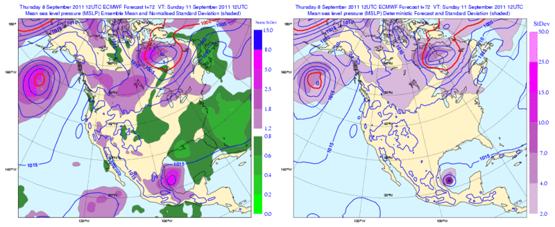
12zECMWF Ensembles are in pretty good agreement thru 72hr placing Nate anywhere from Tampico to about 100 Miles North of Tampico. IMO the Northern Gulf Coast is out of the woods..
0 likes
The following post is NOT an official forecast and should not be used as such. It is just the opinion of the poster and may or may not be backed by sound meteorological data. It is NOT endorsed by any professional institution including storm2k.org For Official Information please refer to the NHC and NWS products.
-
wxman57

- Moderator-Pro Met

- Posts: 23172
- Age: 68
- Joined: Sat Jun 21, 2003 8:06 pm
- Location: Houston, TX (southwest)
Re: ATL: NATE - Models
Finally, a GFS run that makes more sense. If Nate was going north, it wouldn't have been drifting south since yesterday.
0 likes
-
wxman57
- Moderator-Pro Met
- Posts: 23172
- Age: 68
- Joined: Sat Jun 21, 2003 8:06 pm
- Location: Houston, TX (southwest)
Re: ATL: NATE - Tropical Storm - Discussion
And I don't think Nate is going to Texas, either. The longer Nate sits there, the more time for the ridge to rebuild to its north across Texas and Louisiana. Models are coming into very good agreement now in a track west into Mexico, which is the most common track for storms that far south in the BoC. We're not going to see any steering currents that could take Nate toward Texas in the coming week. That ridge will be quite strong over us by Sunday.
I do think the NHC's track is not likely to materialize. Their track is between what were a couple of possibilities and pretty much guaranteed to be wrong. There's nothing to indicate Nate will move only 30 miles per day on Sun, Mon and Tue. They'll be shifting their track westward in the coming advisories.
I do think the NHC's track is not likely to materialize. Their track is between what were a couple of possibilities and pretty much guaranteed to be wrong. There's nothing to indicate Nate will move only 30 miles per day on Sun, Mon and Tue. They'll be shifting their track westward in the coming advisories.
0 likes
-
Over my head

- Tropical Depression

- Posts: 86
- Joined: Sat Aug 18, 2007 7:52 pm
- Location: Southeast Texas
Re: ATL: NATE - Tropical Storm - Discussion
PauleinHouston wrote:HurricaneRobert wrote:One place we know it is not going - Texas.
I'll respectfully disagree with you. The longer Nate sits and meanders (if it sits around) with little in the way of steering influences, the greater the chance for pattern changes to affect the landfall point. While Mexico sure seems a likely target, I still feel there's enough disagreement not to rule out any point in Texas.
It could do like Lee did and splash all over us in Southeast Texas while not really being in Texas. Nate instead of Louisiana as his border uses Mexico and maybe Brownsville and south Texas could get some rain. Optimistically....
0 likes
-
wxman57
- Moderator-Pro Met
- Posts: 23172
- Age: 68
- Joined: Sat Jun 21, 2003 8:06 pm
- Location: Houston, TX (southwest)
Re: ATL: NATE - Tropical Storm - Discussion
Nate could easily go inland well south of 21N, where not a molecule of moisture will reach us in Texas.
0 likes
-
Over my head
- Tropical Depression
- Posts: 86
- Joined: Sat Aug 18, 2007 7:52 pm
- Location: Southeast Texas
Re: ATL: NATE - Tropical Storm - Discussion
wxman57 wrote:Nate could easily go inland well south of 21N, where not a molecule of moisture will reach us in Texas.
boooooo! hisss !
0 likes
-
PauleinHouston
- Tropical Storm
- Posts: 102
- Joined: Mon Aug 13, 2007 10:23 am
- Location: League City, TX
- Contact:
Re: ATL: NATE - Tropical Storm - Discussion
wxman57 wrote:Nate could easily go inland well south of 21N, where not a molecule of moisture will reach us in Texas.
And you're probably right wxman. You've nailed it pretty well as usual and I'm learning from everyone
0 likes
The posts in this forum are NOT official forecasts and should not be used as such. They are just the opinion of this amateur poster and may or may not be backed by sound meteorological data. They are NOT endorsed by any professional institution or storm2k.org. For official information, please refer to NWS products.
Who is online
Users browsing this forum: No registered users and 14 guests