SPAC: ANTHONY (11U/09P) - Tropical Cyclone
Moderator: S2k Moderators

Needs close attention, whilst its not the strongest looking system I've seen these systems that are allowed to bend back westwards and they can be very erratic indeed...
0 likes
Personal Forecast Disclaimer:
The posts in this forum are NOT official forecast and should not be used as such. They are just the opinion of the poster and may or may not be backed by sound meteorological data. They are NOT endorsed by any professional institution or storm2k.org. For official information, please refer to the NHC and NWS products
The posts in this forum are NOT official forecast and should not be used as such. They are just the opinion of the poster and may or may not be backed by sound meteorological data. They are NOT endorsed by any professional institution or storm2k.org. For official information, please refer to the NHC and NWS products

Re: SPO: TROPICAL CYCLONE ANTHONY (97P)
Latest BOM bulletin says 40 kt:
IDQ20018
TROPICAL CYCLONE TECHNICAL BULLETIN: AUSTRALIA - EASTERN REGION
Issued by BRISBANE TROPICAL CYCLONE WARNING CENTRE
at: 1851 UTC 23/01/2011
Name: Tropical Cyclone Anthony
Identifier: 11U
Data At: 1800 UTC
Latitude: 16.7S
Longitude: 155.3E
Location Accuracy: within 60 nm [110 km]
Movement Towards: east [096 deg]
Speed of Movement: 19 knots [35 km/h]
Maximum 10-Minute Wind: 40 knots [75 km/h]
Maximum 3-Second Wind Gust: 55 knots [100 km/h]
Central Pressure: 991 hPa
Radius of 34-knot winds NE quadrant: 120 nm [220 km]
Radius of 34-knot winds SE quadrant: 90 nm [165 km]
Radius of 34-knot winds SW quadrant: 90 nm [165 km]
Radius of 34-knot winds NW quadrant: 120 nm [220 km]
Radius of 48-knot winds NE quadrant:
Radius of 48-knot winds SE quadrant:
Radius of 48-knot winds SW quadrant:
Radius of 48-knot winds NW quadrant:
Radius of 64-knot winds:
Radius of Maximum Winds: 60 nm [110 km]
Dvorak Intensity Code: T2.5/3.0/S0.0/24HRS
Pressure of outermost isobar: 998 hPa
Radius of outermost closed isobar: 120 nm [220 km]
Storm Depth: Medium
FORECAST DATA
Date/Time : Location : Loc. Accuracy: Max Wind : Central Pressure
[UTC] : degrees : nm [km]: knots[km/h]: hPa
+12: 24/0600: 17.6S 158.4E: 090 [165]: 040 [075]: 989
+24: 24/1800: 18.5S 160.1E: 120 [220]: 040 [075]: 987
+36: 25/0600: 18.5S 160.1E: 150 [280]: 040 [075]: 985
+48: 25/1800: 18.1S 158.9E: 185 [345]: 040 [075]: 987
+60: 26/0600: 17.7S 157.4E: 230 [430]: 045 [085]: 985
+72: 26/1800: 17.0S 155.8E: 280 [520]: 050 [095]: 982
REMARKS:
Current location determined by AMSRE 37GHz.
Lack of organized deep convection suggests system remains weak, suffering shear
with proximity to upper trough. Microwave imagery shows a sheared system with
broad low level circulation with limited convection in the southeast quadrant
FT of 2.5 based on MET.
Copyright Commonwealth of Australia
0 likes


-
HURAKAN

- Professional-Met

- Posts: 46086
- Age: 37
- Joined: Thu May 20, 2004 4:34 pm
- Location: Key West, FL
- Contact:
Re:
Chacor wrote:BOM and JTWC seriously disagree on track and intensity now. JTWC have 09P reaching a peak of 80 kt and recurving sharply towards Cairns; BOM have it weakening to a 30 kt tropical low in 12 hours.
Like it's normal, the JTWC did a 180° flip and now agrees with BOM.
0 likes
-
HURAKAN
- Professional-Met
- Posts: 46086
- Age: 37
- Joined: Thu May 20, 2004 4:34 pm
- Location: Key West, FL
- Contact:

WTPS32 PGTW 240300
MSGID/GENADMIN/NAVMARFCSTCEN PEARL HARBOR HI/JTWC//
SUBJ/TROPICAL CYCLONE 09P (ANTHONY) WARNING NR 003//
RMKS/
1. TROPICAL CYCLONE 09P (ANTHONY) WARNING NR 003
02 ACTIVE TROPICAL CYCLONES IN SOUTHPAC
MAX SUSTAINED WINDS BASED ON ONE-MINUTE AVERAGE
WIND RADII VALID OVER OPEN WATER ONLY
---
WARNING POSITION:
240000Z --- NEAR 18.1S 156.9E
MOVEMENT PAST SIX HOURS - 120 DEGREES AT 19 KTS
POSITION ACCURATE TO WITHIN 060 NM
POSITION BASED ON CENTER LOCATED BY SATELLITE
PRESENT WIND DISTRIBUTION:
MAX SUSTAINED WINDS - 040 KT, GUSTS 050 KT
WIND RADII VALID OVER OPEN WATER ONLY
RADIUS OF 034 KT WINDS - 075 NM NORTHEAST QUADRANT
075 NM SOUTHEAST QUADRANT
075 NM SOUTHWEST QUADRANT
065 NM NORTHWEST QUADRANT
REPEAT POSIT: 18.1S 156.9E
---
FORECASTS:
12 HRS, VALID AT:
241200Z --- 19.3S 159.4E
MAX SUSTAINED WINDS - 035 KT, GUSTS 045 KT
WIND RADII VALID OVER OPEN WATER ONLY
DISSIPATING AS A SIGNIFICANT TROPICAL CYCLONE OVER WATER
VECTOR TO 24 HR POSIT: 130 DEG/ 02 KTS
---
24 HRS, VALID AT:
250000Z --- 19.6S 159.8E
MAX SUSTAINED WINDS - 030 KT, GUSTS 040 KT
WIND RADII VALID OVER OPEN WATER ONLY
DISSIPATED AS A SIGNIFICANT TROPICAL CYCLONE OVER WATER
VECTOR TO 36 HR POSIT: 180 DEG/ 02 KTS
---
36 HRS, VALID AT:
251200Z --- 20.0S 159.8E
MAX SUSTAINED WINDS - 030 KT, GUSTS 040 KT
WIND RADII VALID OVER OPEN WATER ONLY
DISSIPATED AS A SIGNIFICANT TROPICAL CYCLONE OVER WATER
VECTOR TO 48 HR POSIT: 285 DEG/ 04 KTS
---
EXTENDED OUTLOOK:
48 HRS, VALID AT:
260000Z --- 19.8S 159.0E
MAX SUSTAINED WINDS - 030 KT, GUSTS 040 KT
WIND RADII VALID OVER OPEN WATER ONLY
DISSIPATED AS A SIGNIFICANT TROPICAL CYCLONE OVER WATER
VECTOR TO 72 HR POSIT: 290 DEG/ 05 KTS
---
72 HRS, VALID AT:
270000Z --- 19.1S 156.9E
MAX SUSTAINED WINDS - 030 KT, GUSTS 040 KT
WIND RADII VALID OVER OPEN WATER ONLY
DISSIPATED AS A SIGNIFICANT TROPICAL CYCLONE OVER WATER
---
REMARKS:
240300Z POSITION NEAR 18.4S 157.5E.
TROPICAL CYCLONE (TC) 09P (ANTHONY) LOCATED APPROXIMATELY 635 NM
EAST OF CAIRNS, AUSTRALIA HAS TRACKED EAST-SOUTHEASTWARD AT 19 KNOTS
OVER THE PAST SIX HOURS. ANIMATED MULTISPECTRAL IMAGERY INDICATES
THE DEEP CONVECTION HAS SHEARED 100 NM TO THE SOUTHEAST OF A
SIGNIFICANTLY WEAKENED LOW LEVEL CIRCULATION CENTER (LLCC). THERE
WAS LOW CONFIDENCE IN THE INITIAL POSITION DUE TO THE UNORGANIZED
LLCC. THE INITIAL INTENSITY WAS BASED ON PGTW, ABRF, AND KNES DVORAK
ESTIMATES RANGING FROM 35 TO 45 KNOTS. AN UPPER LEVEL TROUGH TO THE
EAST HAS DEEPENED MORE THAN PREVIOUSLY EXPECTED AND CAUSED AN
INCREASE IN VERTICAL WIND SHEAR (VWS). WITH THE HIGH VERTICAL WIND
SHEAR, TC 09P SHOULD NOW CONTINUE TO WEAKEN AND DISSIPATE BELOW 35
KNOTS WITHIN THE NEXT 24 HOURS. AFTER THE UPPER LEVEL TROUGH PASSES,
THE LOW LEVEL STEERING RIDGE TO THE SOUTH IS EXPECTED TO BUILD AND
TURN THE SYSTEM BACK WESTWARD. THE CURRENT FORECAST PHILOSOPHY HAS
CHANGED FROM THE PREVIOUS FORECAST. THE ALTERNATE SCENARIO IS STILL
POSSIBLE WHERE TC 09P WILL RE-INTENSIFY AFTER THE PASSAGE OF THE
UPPER LEVEL TROUGH AS SOME OF THE MODELS ARE STILL INDICATING.
HOWEVER, WITH THE CURRENT MAGNITUDE OF THE TROUGH, THIS SCENARIO IS
UNLIKELY. MAXIMUM SIGNIFICANT WAVE HEIGHT AT 240000Z IS 13 FEET.
NEXT WARNINGS AT 241500Z AND 250300Z. REFER TO TROPICAL CYCLONE 08P
(WILMA) WARNINGS (WTPS31 PGTW) FOR TWELVE-HOURLY UPDATES.//
NNNN
0 likes

-
Crostorm

- Category 5

- Posts: 2060
- Age: 49
- Joined: Mon Dec 25, 2006 3:51 pm
- Location: Croatia-Europe
- Contact:
Re: SPO: TROPICAL CYCLONE ANTHONY (97P)
IDQ20018
TROPICAL CYCLONE TECHNICAL BULLETIN: AUSTRALIA - EASTERN REGION
Issued by BRISBANE TROPICAL CYCLONE WARNING CENTRE
at: 0704 UTC 24/01/2011
Name: Tropical Cyclone Anthony
Identifier: 11U
Data At: 0600 UTC
Latitude: 18.5S
Longitude: 158.4E
Location Accuracy: within 40 nm [75 km]
Movement Towards: east southeast [118 deg]
Speed of Movement: 19 knots [36 km/h]
Maximum 10-Minute Wind: 35 knots [65 km/h]
Maximum 3-Second Wind Gust: 50 knots [95 km/h]
Central Pressure: 995 hPa
Radius of 34-knot winds NE quadrant: 30 nm [55 km]
Radius of 34-knot winds SE quadrant: 120 nm [220 km]
Radius of 34-knot winds SW quadrant: 120 nm [220 km]
Radius of 34-knot winds NW quadrant: 30 nm [55 km]
Radius of 48-knot winds NE quadrant:
Radius of 48-knot winds SE quadrant:
Radius of 48-knot winds SW quadrant:
Radius of 48-knot winds NW quadrant:
Radius of 64-knot winds:
Radius of Maximum Winds: 45 nm [85 km]
Dvorak Intensity Code: T2.5/3.0/S0.0/24HRS
Pressure of outermost isobar: 1000 hPa
Radius of outermost closed isobar: 150 nm [280 km]
Storm Depth: Medium
FORECAST DATA
Date/Time : Location : Loc. Accuracy: Max Wind : Central Pressure
[UTC] : degrees : nm [km]: knots[km/h]: hPa
+12: 24/1800: 19.2S 160.1E: 100 [185]: 035 [065]: 992
+24: 25/0600: 19.3S 160.1E: 135 [250]: 035 [065]: 990
+36: 25/1800: 18.8S 159.0E: 150 [280]: 035 [065]: 992
+48: 26/0600: 18.5S 157.5E: 190 [350]: 035 [065]: 993
+60: 26/1800: 17.9S 155.8E: 230 [425]: 035 [065]: 993
+72: 27/0600: 17.3S 154.1E: 270 [500]: 035 [065]: 993
REMARKS:
Shear pattern with approximately 0.75 of a degree separation between the low
level centre and the deep convection located to the south of the system, giving
DT of 2.5. MT 2.5 and PT 2.0. FT based on DT. CI maintained at 0.5 greater than
the FT.
Deep convection weakened out significantly early Monday morning prior to
redeveloping to the south of the system during the day. Moderate to strong
northwesterly shear is persisting across Tropical Cyclone Anthony with an upper
trough extending across the western Coral Sea.
Copyright Commonwealth of Australia
==
The next bulletin for this system will be issued by: 24/1300 UTC by Brisbane
TCWC.
0 likes

-
Crostorm
- Category 5
- Posts: 2060
- Age: 49
- Joined: Mon Dec 25, 2006 3:51 pm
- Location: Croatia-Europe
- Contact:
Re: SPO: TROPICAL CYCLONE ANTHONY (97P)
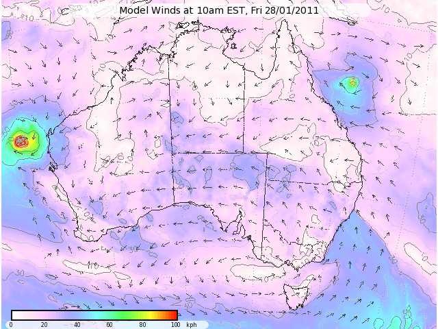
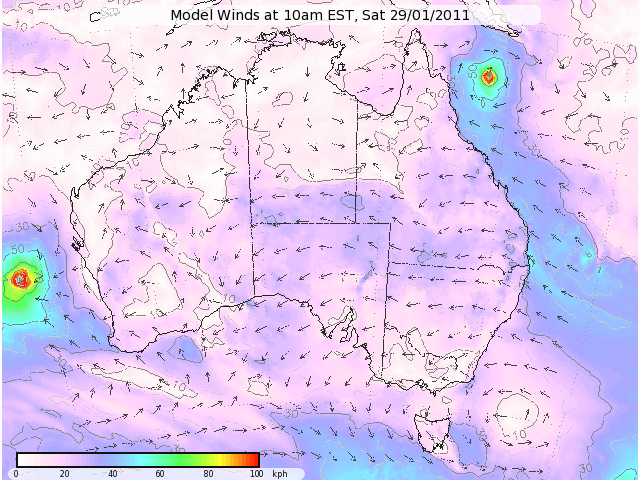
Here is the forecast from Gfs for 29.1. and posible landfall
http://forecasts.bsch.au.com/stormcast? ... #stormcast

http://forecasts.bsch.au.com/stormcast? ... #stormcast
0 likes

-
HURAKAN
- Professional-Met
- Posts: 46086
- Age: 37
- Joined: Thu May 20, 2004 4:34 pm
- Location: Key West, FL
- Contact:
TROPICAL CYCLONE TECHNICAL BULLETIN: AUSTRALIA - EASTERN REGION
Issued by BRISBANE TROPICAL CYCLONE WARNING CENTRE
at: 1247 UTC 24/01/2011
Name: Tropical Cyclone Anthony
Identifier: 11U
Data At: 1200 UTC
Latitude: 19.0S
Longitude: 159.8E
Location Accuracy: within 40 nm [75 km]
Movement Towards: east southeast [115 deg]
Speed of Movement: 17 knots [31 km/h]
Maximum 10-Minute Wind: 35 knots [65 km/h]
Maximum 3-Second Wind Gust: 50 knots [95 km/h]
Central Pressure: 997 hPa
Radius of 34-knot winds NE quadrant: 90 nm [165 km]
Radius of 34-knot winds SE quadrant: 120 nm [220 km]
Radius of 34-knot winds SW quadrant: 120 nm [220 km]
Radius of 34-knot winds NW quadrant: 45 nm [85 km]
Radius of 48-knot winds NE quadrant:
Radius of 48-knot winds SE quadrant:
Radius of 48-knot winds SW quadrant:
Radius of 48-knot winds NW quadrant:
Radius of 64-knot winds:
Radius of Maximum Winds: 40 nm [75 km]
Dvorak Intensity Code: T3.0/3.0/S0.0/24HRS
Pressure of outermost isobar: 1002 hPa
Radius of outermost closed isobar: 200 nm [370 km]
Storm Depth: Deep
FORECAST DATA
Date/Time : Location : Loc. Accuracy: Max Wind : Central Pressure
[UTC] : degrees : nm [km]: knots[km/h]: hPa
+12: 25/0000: 19.4S 160.4E: 080 [150]: 035 [065]: 990
+24: 25/1200: 19.1S 159.7E: 150 [280]: 035 [065]: 992
+36: 26/0000: 18.8S 158.4E: 160 [295]: 035 [065]: 992
+48: 26/1200: 18.3S 156.8E: 190 [350]: 035 [065]: 993
+60: 27/0000: 17.9S 155.0E: 230 [425]: 035 [065]: 993
+72: 27/1200: 17.0S 153.5E: 270 [500]: 035 [065]: 993
REMARKS:
Shear pattern with approximately 0.3 of a degree separation between the low
level centre and the deep convection located to the south of the system, giving
DT of 3.5. MT 3.0 and PT 2.5. FT based on MT. DT is not clear due to poor
confidence in the location of the low level centre.
Deep convection has significantly redeveloped to the south of the system during
Monday and has persisted into the night. Moderate to strong northwesterly shear
is persisting across Tropical Cyclone Anthony with an upper trough extending
across the Coral Sea. A mid level ridge will begin to extend across the central
Coral Sea during Tuesday and will begin to steer Anthony in a west northwesterly
direction later in the day and into Wednesday.
Copyright Commonwealth of Australia
==
The next bulletin for this system will be issued by: 24/1900 UTC by Brisbane
TCWC.
0 likes

-
HURAKAN
- Professional-Met
- Posts: 46086
- Age: 37
- Joined: Thu May 20, 2004 4:34 pm
- Location: Key West, FL
- Contact:
TROPICAL CYCLONE TECHNICAL BULLETIN: AUSTRALIA - EASTERN REGION
Issued by BRISBANE TROPICAL CYCLONE WARNING CENTRE
at: 1851 UTC 24/01/2011
Name: Tropical Cyclone Anthony
Identifier: 11U
Data At: 1800 UTC
Latitude: 19.0S
Longitude: 160.1E
Location Accuracy: within 40 nm [75 km]
Movement Towards: east southeast [102 deg]
Speed of Movement: 7 knots [13 km/h]
Maximum 10-Minute Wind: 40 knots [75 km/h]
Maximum 3-Second Wind Gust: 55 knots [100 km/h]
Central Pressure: 988 hPa
Radius of 34-knot winds NE quadrant: 90 nm [165 km]
Radius of 34-knot winds SE quadrant: 120 nm [220 km]
Radius of 34-knot winds SW quadrant: 120 nm [220 km]
Radius of 34-knot winds NW quadrant: 90 nm [165 km]
Radius of 48-knot winds NE quadrant:
Radius of 48-knot winds SE quadrant:
Radius of 48-knot winds SW quadrant:
Radius of 48-knot winds NW quadrant:
Radius of 64-knot winds:
Radius of Maximum Winds: 30 nm [55 km]
Dvorak Intensity Code: T2.0/3.0/W0.5/24HRS
Pressure of outermost isobar: 1000 hPa
Radius of outermost closed isobar: 120 nm [220 km]
Storm Depth: Shallow
FORECAST DATA
Date/Time : Location : Loc. Accuracy: Max Wind : Central Pressure
[UTC] : degrees : nm [km]: knots[km/h]: hPa
+12: 25/0600: 19.1S 160.2E: 070 [130]: 040 [075]: 987
+24: 25/1800: 18.6S 159.1E: 100 [185]: 040 [075]: 988
+36: 26/0600: 18.1S 157.7E: 130 [245]: 040 [075]: 989
+48: 26/1800: 17.6S 155.8E: 165 [305]: 040 [075]: 990
+60: 27/0600: 16.9S 154.4E: 210 [395]: 040 [075]: 989
+72: 27/1800: 15.7S 153.1E: 260 [480]: 040 [075]: 989
REMARKS:
FT based on MET with DT poor due to lack of deep convection near the LLCC.
Constraints have been used to keep CI at 3.0.
Moderate to strong northwesterly shear is persisting across Tropical Cyclone
Anthony with an upper trough extending across the Coral Sea. A mid level ridge
will begin to extend across the central Coral Sea during Tuesday and will begin
to steer Anthony in a west northwesterly direction later in the day and into
Wednesday.
Brisbane TCWC will continue to issue products despite the system being east of
160E as it is forecast to move west of 160E in the next 12-18 hours.
Copyright Commonwealth of Australia
==
The next bulletin for this system will be issued by: 25/0100 UTC by Brisbane
TCWC.
0 likes


-
Grifforzer
- Category 1

- Posts: 418
- Joined: Thu Feb 26, 2009 11:27 pm
At 10:00 AM EST, Tropical Cyclone Anthony, Category One (992 hPa) located 19.4S 160.8E, or 1230 km east of Mackay has 10 minute sustained winds of 35 knots with gusts of 50 knots. The cyclone is reported as moving east southeast at 8 knots.
Gale Force Winds
90 NM in northern quadrant
120 NM in southern quadrant
Dvorak Intensity: T1.5/3.0/W1.5/24HRS
Forecast and Intensity
12 HRS: 19.3S 160.2E - 30 knots (Tropical Low)
24 HRS: 19.0S 158.8E - 30 knots (Tropical Low)
48 HRS: 18.2S 154.4E - 30 knots (Tropical Low)
72 HRS: 16.5S 151.6E - 40 knots (CAT 1)
FT 1.5 based on shear with 2.5 degree separation to deeper convection. CI at 3.0 due to constraints. The system is undergoing strong NW shear and with its slow or WNW forecast movement is likely to be classified a tropical low in the next 6 hours and is unlikely to redevelop into a tropical cyclone in the next 24 to 48 hours.
Longer term global models have redevelopment in the northwest Coral Sea.
Brisbane TCWC will continue to issue products despite the system being east of 160E as it is forecast to move west of 160E in the next 12-18 hours.
The next tropical cyclone bulletin will be issued at 7:00 AM UTC..
0 likes


Who is online
Users browsing this forum: No registered users and 28 guests