NIO: DEPRESSION (01A)

Moderator: S2k Moderators

Message
Author
User avatar
HURAKAN
Professional-Met
Professional-Met
Posts: 46086
Age: 37
Joined: Thu May 20, 2004 4:34 pm
Location: Key West, FL
Contact:

NIO: DEPRESSION (01A)

#1 Postby HURAKAN » Wed Jun 01, 2011 6:53 pm

Image

Latest
Last edited by HURAKAN on Sat Jun 11, 2011 11:34 am, edited 1 time in total.
0 likes   

User avatar
HURAKAN
Professional-Met
Professional-Met
Posts: 46086
Age: 37
Joined: Thu May 20, 2004 4:34 pm
Location: Key West, FL
Contact:

#2 Postby HURAKAN » Wed Jun 01, 2011 6:55 pm

Image

Latest GFS
0 likes   

User avatar
Chacor
Category 5
Category 5
Posts: 10229
Joined: Mon Oct 02, 2006 10:43 pm
Location: Singapore

#3 Postby Chacor » Wed Jun 01, 2011 7:12 pm

Another Oman hit? Gonu was rare, this would be ridiculous.
0 likes   

User avatar
HURAKAN
Professional-Met
Professional-Met
Posts: 46086
Age: 37
Joined: Thu May 20, 2004 4:34 pm
Location: Key West, FL
Contact:

#4 Postby HURAKAN » Wed Jun 01, 2011 7:28 pm

Image

Latest
0 likes   

soul2006
Tropical Wave
Tropical Wave
Posts: 8
Age: 40
Joined: Mon May 31, 2010 9:01 am

#5 Postby soul2006 » Wed Jun 01, 2011 9:10 pm

98A.INVEST.15kts.1010mb.13.6N.69.9E
0 likes   

User avatar
KWT
Category 5
Category 5
Posts: 31390
Joined: Tue Aug 17, 2004 11:02 am
Location: UK!!!

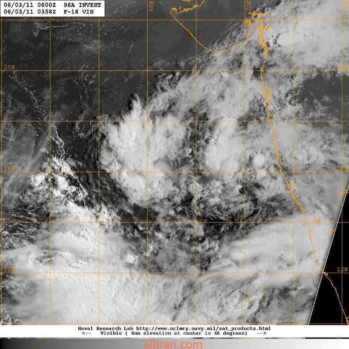
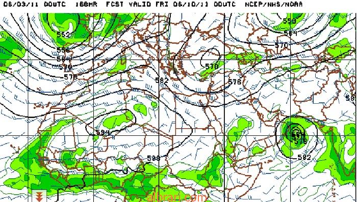
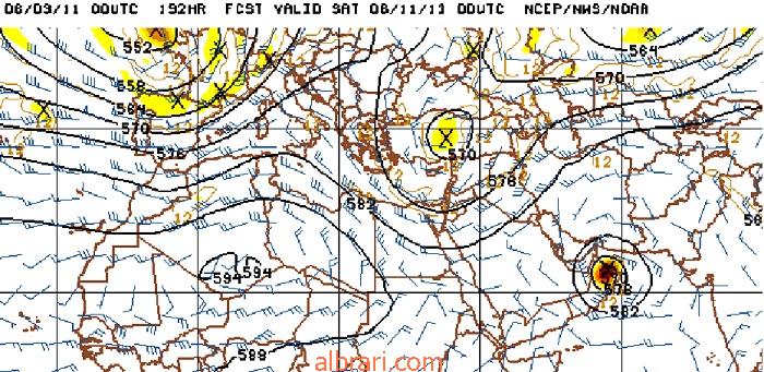
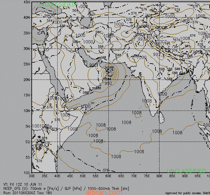
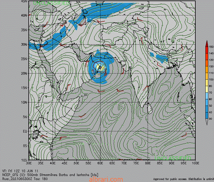
#6 Postby KWT » Thu Jun 02, 2011 4:01 am

ECM still develops this into a pretty powerful system, I'd estimate probably cat. 3/4 based on the ECM.

Its slower moving on the ECM then the GFS as well...

Looks good for development IMO.
0 likes   
Personal Forecast Disclaimer:
The posts in this forum are NOT official forecast and should not be used as such. They are just the opinion of the poster and may or may not be backed by sound meteorological data. They are NOT endorsed by any professional institution or storm2k.org. For official information, please refer to the NHC and NWS products

User avatar
salmon123
Tropical Storm
Tropical Storm
Posts: 100
Age: 43
Joined: Mon Apr 28, 2008 1:56 pm
Location: karachi pakistan
Contact:

#7 Postby salmon123 » Thu Jun 02, 2011 6:14 am

The Actual movement of 98A is still here n there... Some models shows north north East some differs what do u think Hurakan ?
0 likes   

User avatar
Cyclenall
Category 5
Category 5
Posts: 6627
Joined: Thu Jun 08, 2006 10:01 pm
Location: Ontario, Canada

#8 Postby Cyclenall » Thu Jun 02, 2011 12:17 pm

If this does develop and strikes Oman again as a powerful cyclone, the two would both be during the month of June.
0 likes   

User avatar
KWT
Category 5
Category 5
Posts: 31390
Joined: Tue Aug 17, 2004 11:02 am
Location: UK!!!

#9 Postby KWT » Thu Jun 02, 2011 5:18 pm

Surprisingly the ECM doesn't really develop it, thats quite different from most runs recently...
0 likes   
Personal Forecast Disclaimer:
The posts in this forum are NOT official forecast and should not be used as such. They are just the opinion of the poster and may or may not be backed by sound meteorological data. They are NOT endorsed by any professional institution or storm2k.org. For official information, please refer to the NHC and NWS products

User avatar
HURAKAN
Professional-Met
Professional-Met
Posts: 46086
Age: 37
Joined: Thu May 20, 2004 4:34 pm
Location: Key West, FL
Contact:

Re:

#10 Postby HURAKAN » Thu Jun 02, 2011 8:50 pm

salmon123 wrote:The Actual movement of 98A is still here n there... Some models shows north north East some differs what do u think Hurakan ?


Image

Image

Image

My take from the computer models is that once it forms, the environment looks conducive for intensification.
0 likes   

User avatar
HURAKAN
Professional-Met
Professional-Met
Posts: 46086
Age: 37
Joined: Thu May 20, 2004 4:34 pm
Location: Key West, FL
Contact:

#11 Postby HURAKAN » Thu Jun 02, 2011 11:58 pm

Image

Latest
0 likes   

User avatar
salmon123
Tropical Storm
Tropical Storm
Posts: 100
Age: 43
Joined: Mon Apr 28, 2008 1:56 pm
Location: karachi pakistan
Contact:

Re: NIO: INVEST 98A

#12 Postby salmon123 » Fri Jun 03, 2011 1:16 am

Track looks similar to GONU 2007
Image
0 likes   

User avatar
KWT
Category 5
Category 5
Posts: 31390
Joined: Tue Aug 17, 2004 11:02 am
Location: UK!!!

#13 Postby KWT » Fri Jun 03, 2011 4:05 am

Once again the 00z ECM does not develop this system, a markedly different forecast from the agreessive runs of a few days ago.
0 likes   
Personal Forecast Disclaimer:
The posts in this forum are NOT official forecast and should not be used as such. They are just the opinion of the poster and may or may not be backed by sound meteorological data. They are NOT endorsed by any professional institution or storm2k.org. For official information, please refer to the NHC and NWS products

alhddar
Tropical Depression
Tropical Depression
Posts: 62
Joined: Sun Feb 17, 2008 4:27 am

#14 Postby alhddar » Fri Jun 03, 2011 5:04 am

98A.INVEST.15kts.1010mb.15.9N.69.1E.

Image
0 likes   

alhddar
Tropical Depression
Tropical Depression
Posts: 62
Joined: Sun Feb 17, 2008 4:27 am

#15 Postby alhddar » Fri Jun 03, 2011 5:07 am

Image


Image
0 likes   

alhddar
Tropical Depression
Tropical Depression
Posts: 62
Joined: Sun Feb 17, 2008 4:27 am

#16 Postby alhddar » Fri Jun 03, 2011 5:56 am

Image


Image


Image


Image
0 likes   

alhddar
Tropical Depression
Tropical Depression
Posts: 62
Joined: Sun Feb 17, 2008 4:27 am

#17 Postby alhddar » Fri Jun 03, 2011 6:22 am

Image


Image
0 likes   

alhddar
Tropical Depression
Tropical Depression
Posts: 62
Joined: Sun Feb 17, 2008 4:27 am

#18 Postby alhddar » Fri Jun 03, 2011 6:30 am

Image
Last edited by alhddar on Fri Jun 03, 2011 6:41 am, edited 1 time in total.
0 likes   

alhddar
Tropical Depression
Tropical Depression
Posts: 62
Joined: Sun Feb 17, 2008 4:27 am

#19 Postby alhddar » Fri Jun 03, 2011 6:40 am

Image


Image


Image


Image
0 likes   

alhddar
Tropical Depression
Tropical Depression
Posts: 62
Joined: Sun Feb 17, 2008 4:27 am

#20 Postby alhddar » Fri Jun 03, 2011 6:43 am

Image
0 likes   


Return to “2011”

Who is online

Users browsing this forum: No registered users and 44 guests