WPAC: SARIKA - Tropical Depression
Moderator: S2k Moderators
-
dexterlabio
- Category 5

- Posts: 3407
- Joined: Sat Oct 24, 2009 11:50 pm
Re: WPAC: INVEST 92W
It could be that this will be renamed as another invest once they pick this up again.
0 likes
Personal Forecast Disclaimer:
The posts in this forum are NOT official forecast and should not be used as such. They are just the opinion of the poster and may or may not be backed by sound meteorological data. They are NOT endorsed by any professional institution or storm2k.org. For official information, please refer to the NHC and NWS products.
The posts in this forum are NOT official forecast and should not be used as such. They are just the opinion of the poster and may or may not be backed by sound meteorological data. They are NOT endorsed by any professional institution or storm2k.org. For official information, please refer to the NHC and NWS products.
-
StormingB81

- S2K Supporter

- Posts: 5676
- Age: 42
- Joined: Thu Aug 27, 2009 1:45 am
- Location: Rockledge, Florida

-
StormingB81
- S2K Supporter
- Posts: 5676
- Age: 42
- Joined: Thu Aug 27, 2009 1:45 am
- Location: Rockledge, Florida


Re: WPAC: INVEST 92W
The following post is NOT an official forecast and should not be used as such. It is just the opinion of the poster and may or may not be backed by sound meteorological data. It is NOT endorsed by any professional institution including storm2k.org. For Official Information please refer to the NHC and NWS products.
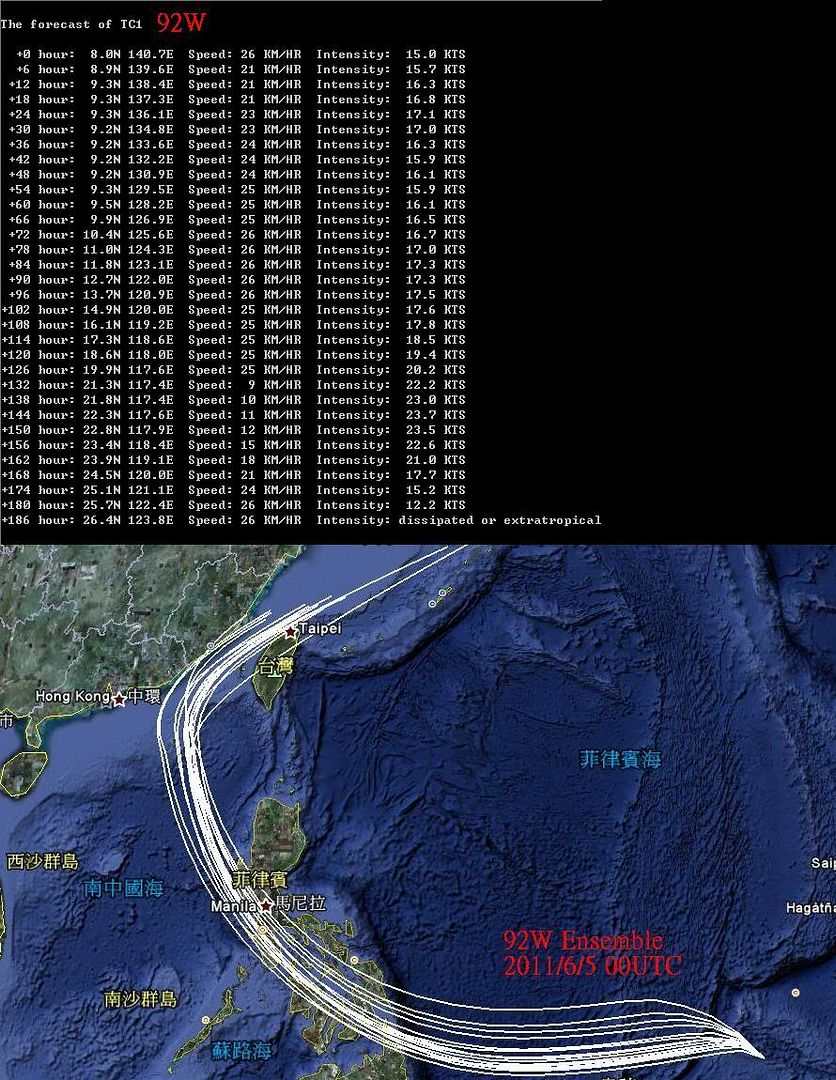
My personal forecast #1 for 92W
Source: My small program ,which called "Typhoon Predictor V4.02" with Ensemble
Initial time: 2011/6/5 00 UTC
All the 16 models agree with that the peak intensity of 92W may be within 20~28 KTS.
I post one of the intensity forecast and plot all 16 paths.
0 likes
-
Extratropical94

- Professional-Met

- Posts: 3535
- Age: 29
- Joined: Wed Oct 20, 2010 6:36 am
- Location: Hamburg, Germany
- Contact:
Re:
Extratropical94 wrote:Did you write that program yourself, it looks very interesting and i can't find it on Google.
And where does it get the data from?
Yes,it is programed by me and so you can't find it on Google.
The input data of the model are from:
1.Shear Tendency pictures
2.Upper Level Divergence pictures
3.Lower Level Convergence pictures
4.Sea Surface Temperature pictures
5.The conditions and positions of High atmospheric pressure
6.Satellite nephogram
7.Topographies
We can get these pictures on CIMSS or other sites.
0 likes
-
phwxenthusiast
- Category 2

- Posts: 637
- Joined: Wed Mar 24, 2010 3:10 am
- Location: Holbrook, NY (Long Island)
-
ManilaTC

- WesternPacificWeather.com

- Posts: 592
- Age: 45
- Joined: Mon Oct 26, 2009 5:13 am
- Location: Mandaluyong City, Philippines
- Contact:
Re: WPAC: INVEST 92W
doraboy wrote:The following post is NOT an official forecast and should not be used as such. It is just the opinion of the poster and may or may not be backed by sound meteorological data. It is NOT endorsed by any professional institution including storm2k.org. For Official Information please refer to the NHC and NWS products.
My personal forecast #1 for 92W
Source: My small program ,which called "Typhoon Predictor V4.02" with Ensemble
Initial time: 2011/6/5 00 UTC
All the 16 models agree with that the peak intensity of 92W may be within 20~28 KTS.
I post one of the intensity forecast and plot all 16 paths.
Cool... can we have a copy
Just askin...
0 likes
The above post is NOT official and should not be used as such. It is my opinion and may or may not be backed by sound meteorological data. It is not endorsed by any professional institution or storm2k.org. Please refer to your official national weather agency.
WEB http://goo.gl/JDiKXB | FB https://goo.gl/N5sIle | @ManilaTC
WEB http://goo.gl/JDiKXB | FB https://goo.gl/N5sIle | @ManilaTC
-
StormingB81
- S2K Supporter
- Posts: 5676
- Age: 42
- Joined: Thu Aug 27, 2009 1:45 am
- Location: Rockledge, Florida
Is this the same thing coming back up?
(1) AN AREA OF CONVECTION HAS PERSISTED NEAR 8.9N 126.4E,
APPROXIMATELY 470 NM SOUTHEAST OF MANILA, PHILIPPINES. ANIMATED
INFRARED SATELLITE IMAGERY INDICATES AN INCREASINGLY ORGANIZED LOW
LEVEL CIRCULATION CENTER JUST OFF THE EAST COAST OF MINDANAO,
PHILIPPINES. A 061700Z AMSU-B 89 GHZ MICROWAVE SATELLITE IMAGE SHOWS
SHALLOW CONVECTION CURVING INTO THE OUTER EDGES OF THE LOW LEVEL
CIRCULATION CENTER (LLCC). UPPER LEVEL STREAMLINE ANALYSIS PLACES
92W JUST SOUTH OF A RIDGE AXIS IN A REGION OF DIFFLUENCE AND
FAVORABLE (5-10 KNOTS) VERTICAL WIND SHEAR. SEA SURFACE TEMPERATURES
ARE FAVORABLE (>31 DEGREES CELSIUS) AS WELL. MAXIMUM SUSTAINED
SURFACE WINDS ARE ESTIMATED AT 15 TO 20 KNOTS. MINIMUM SEA LEVEL
PRESSURE IS ESTIMATED TO BE NEAR 1006 MB. DUE TO THESE FAVORABLE
ENVIRONMENTAL CONDITIONS AND INCREASED ORGANIZATION OF THE SYSTEM,
THE POTENTIAL FOR THE DEVELOPMENT OF A SIGNIFICANT TROPICAL CYCLONE
WITHIN THE NEXT 24 HOURS IS LOW.
0 likes
-
RobWESTPACWX
- WestPACMet

- Posts: 1616
- Joined: Fri Sep 17, 2010 2:26 am
- Location: Tokyo, Japan
- Contact:
Re: WPAC: INVEST 92W
A lot more organization with it today, I'm sure if it wasn't for the fact it was sitting over the PI all day we would have a much stronger system on our hands.
0 likes
Satellites, Charts and Forecasting tools for East Asia at WESTERNPACIFICWEATHER.COM
-
ManilaTC
- WesternPacificWeather.com
- Posts: 592
- Age: 45
- Joined: Mon Oct 26, 2009 5:13 am
- Location: Mandaluyong City, Philippines
- Contact:
Expecting some medium to heavy rain today...
0 likes
The above post is NOT official and should not be used as such. It is my opinion and may or may not be backed by sound meteorological data. It is not endorsed by any professional institution or storm2k.org. Please refer to your official national weather agency.
WEB http://goo.gl/JDiKXB | FB https://goo.gl/N5sIle | @ManilaTC
WEB http://goo.gl/JDiKXB | FB https://goo.gl/N5sIle | @ManilaTC
Re: WPAC: INVEST 92W
Yes, 92W is back on NRL site.
92WINVEST.15kts-1010mb-125N-1226E.
18Z JMA analysis:
LOW PRESSURE AREA 1008 HPA NEAR 12N 123E NW 15 KT.
Latest imagery shows more banding than the Caribbean system briefly given a 50% chance of development ever did:

92WINVEST.15kts-1010mb-125N-1226E.
18Z JMA analysis:
LOW PRESSURE AREA 1008 HPA NEAR 12N 123E NW 15 KT.
Latest imagery shows more banding than the Caribbean system briefly given a 50% chance of development ever did:
0 likes
-
oaba09
- S2K Supporter
- Posts: 1496
- Age: 37
- Joined: Thu Oct 01, 2009 10:02 am
- Location: Valenzuela, Philippines
- Contact:
Re: WPAC: INVEST 92W
It has been raining continuously here the whole morning...I'm just hoping that there will be no floods(Don't wanna get stuck here in the office)...
0 likes
JTWC just upgraded development chances to medium:
ABPW10 PGTW 080600
MSGID/GENADMIN/NAVMARFCSTCEN PEARL HARBOR HI/JTWC//
SUBJ/SIGNIFICANT TROPICAL WEATHER ADVISORY FOR THE WESTERN AND
/SOUTH PACIFIC OCEANS/080600Z-090600ZJUN2011//
RMKS/
1. WESTERN NORTH PACIFIC AREA (180 TO MALAY PENINSULA):
A. TROPICAL CYCLONE SUMMARY: NONE.
B. TROPICAL DISTURBANCE SUMMARY:
(1) THE AREA OF CONVECTION PREVIOUSLY LOCATED NEAR 9.5N
125.2E, IS NOW LOCATED NEAR 13.4N 121.5E, APPROXIMATELY 75 NM
SOUTH-SOUTHEAST OF MANILA, PHILIPPINES. ANIMATED MULTISPECTRAL
SATELLITE IMAGERY SHOWS THE SYSTEM HAS MOVED NORTHWESTWARD ACROSS
THE VISAYAN ISLANDS OVER THE PAST 24 HOURS AND HAS REGAINED SOME
CONSOLIDATION. FORMATIVE CONVECTIVE BANDS HAVE ALSO DEEPENED, AS
EVIDENT ON A 080232Z TRMM MICROWAVE IMAGE. UPPER LEVEL ANALYSIS
INDICATES THE SYSTEM IS UNDER A RIDGE AXIS IN AN AREA OF LOW
(5-10KT) VERTICAL WIND SHEAR. ANIMATED WATER VAPOR IMAGERY SHOWS
GOOD OUTFLOW IN THE NORTHEAST QUADRANT INTO A TROPICAL UPPER
TROPOSPHERIC TROUGH. IN VIEW OF THE IMPROVED ENVIRONMENTAL
CONDITIONS, THE POTENTIAL FOR THE DEVELOPMENT OF A SIGNIFICANT
TROPICAL CYCLONE WITHIN THE NEXT 24 HOURS IS UPGRADED TO MEDIUM.
(2) NO OTHER SUSPECT AREAS.
2. SOUTH PACIFIC AREA (WEST COAST OF SOUTH AMERICA TO 135 EAST):
A. TROPICAL CYCLONE SUMMARY: NONE.
B. TROPICAL DISTURBANCE SUMMARY: NONE.//
NNNN
0 likes

Heavy rains since early morning here in Batangas
0 likes
The above post is not official and should not be used as such. It is the opinion of the poster and may or may not be backed by sound meteorological data. It is not endorsed by any professional institution or storm2k.org. For official information, please refer to the NHC and NWS products.
-
Typhoon Hunter
- WesternPacificWeather.com
- Posts: 1215
- Age: 40
- Joined: Wed Oct 11, 2006 11:37 am
- Location: Hong Kong
- Contact:
Some very deep convective bands with 92W right now off west coast of Luzon in SCS and pressure down to 1004hPa in Manila. Looks very impressive on satellite and given the low shear and high SSTs it should have a good shot of development once over open waters of SCS. Despite all that - models not picking up on this much at all, could that be because it's been spinning up over the Philippines and throwing them off?
0 likes
-
phwxenthusiast
- Category 2
- Posts: 637
- Joined: Wed Mar 24, 2010 3:10 am
- Location: Holbrook, NY (Long Island)
-
climateconcern23
- Tropical Low

- Posts: 35
- Age: 33
- Joined: Sat Mar 05, 2011 4:38 am
- Location: Philippines
- Contact:

-
ManilaTC
- WesternPacificWeather.com
- Posts: 592
- Age: 45
- Joined: Mon Oct 26, 2009 5:13 am
- Location: Mandaluyong City, Philippines
- Contact:
Center over South Manila now... Heavy Rains expected overnight... 26kph winds registered at wunderground
0 likes
The above post is NOT official and should not be used as such. It is my opinion and may or may not be backed by sound meteorological data. It is not endorsed by any professional institution or storm2k.org. Please refer to your official national weather agency.
WEB http://goo.gl/JDiKXB | FB https://goo.gl/N5sIle | @ManilaTC
WEB http://goo.gl/JDiKXB | FB https://goo.gl/N5sIle | @ManilaTC
Who is online
Users browsing this forum: No registered users and 98 guests