Dunno which system this is so bear with me..
BEGIN
NHC_ATCF
invest_al962011.invest
FSTDA
R
U
040
010
0000
201107071157
NONE
NOTIFY=ATRP
END
INVEST, AL, L, , , , , 96, 2011, DB, O, 2011070706, 9999999999, , , , , , METWATCH, , AL962011
AL, 96, 2011070612, , BEST, 0, 237N, 828W, 20, 1011, DB, 0, , 0, 0, 0, 0,
AL, 96, 2011070618, , BEST, 0, 240N, 831W, 20, 1011, DB, 0, , 0, 0, 0, 0,
AL, 96, 2011070700, , BEST, 0, 242N, 833W, 20, 1011, DB, 0, , 0, 0, 0, 0,
AL, 96, 2011070706, , BEST, 0, 244N, 834W, 20, 1011, DB, 34, NEQ, 0, 0, 0, 0, 1013, 120, 60, 0, 0, L, 0, , 0, 0, INVEST, S,
ATL: INVEST 96L - Discussion
Moderator: S2k Moderators
-
lester

- S2K Supporter

- Posts: 1305
- Age: 35
- Joined: Sat Aug 27, 2005 5:21 pm
- Location: Washington, DC
- Contact:
ATL: INVEST 96L - Discussion
0 likes
-
cycloneye

- Admin

- Posts: 139087
- Age: 67
- Joined: Thu Oct 10, 2002 10:54 am
- Location: San Juan, Puerto Rico
ATL: Ex INVEST 96L - Models
Code: Select all
WHXX01 KWBC 071201
CHGHUR
TROPICAL CYCLONE GUIDANCE MESSAGE
NWS NATIONAL HURRICANE CENTER MIAMI FL
1201 UTC THU JUL 7 2011

DISCLAIMER...NUMERICAL MODELS ARE SUBJECT TO LARGE ERRORS.
PLEASE REFER TO NHC OFFICIAL FORECASTS FOR TROPICAL CYCLONE
AND SUBTROPICAL CYCLONE INFORMATION.

ATLANTIC OBJECTIVE AIDS FOR

DISTURBANCE INVEST (AL962011) 20110707 0600 UTC

        ...00 HRS...   ...12 HRS...   ...24 HRS. ..   ...36 HRS...
        110707  0600   110707  1800   110708  0600   110708  1800

         LAT    LON     LAT    LON     LAT    LON     LAT    LON
BAMS    24.4N  83.4W   25.6N  84.6W   26.5N  85.5W   27.7N  86.2W
BAMD    24.4N  83.4W   25.8N  83.9W   27.3N  84.4W   29.0N  84.9W
BAMM    24.4N  83.4W   25.4N  84.5W   26.4N  85.3W   27.6N  86.1W
LBAR    24.4N  83.4W   25.2N  83.8W   26.4N  84.4W   27.8N  84.7W
SHIP        20KTS          23KTS          27KTS          32KTS
DSHP        20KTS          23KTS          27KTS          32KTS

        ...48 HRS...   ...72 HRS...   ...96 HRS. ..   ..120 HRS...
        110709  0600   110710  0600   110711  0600   110712  0600

         LAT    LON     LAT    LON     LAT    LON     LAT    LON
BAMS    28.6N  86.5W   30.2N  86.7W   31.2N  87.3W   31.2N  88.6W
BAMD    30.7N  84.6W   32.1N  82.5W   31.4N  82.9W   30.1N  85.3W
BAMM    28.6N  86.4W   30.3N  87.1W   31.2N  88.4W   31.1N  90.3W
LBAR    29.2N  84.4W   32.3N  82.1W   34.9N  80.0W   37.2N  77.5W
SHIP        33KTS          37KTS          42KTS          43KTS
DSHP        33KTS          37KTS          28KTS          27KTS

         ...INITIAL CONDITIONS...
LATCUR =  24.4N LONCUR =  83.4W DIRCUR = 320DEG SPDCUR =   3KT
LATM12 =  24.0N LONM12 =  83.1W DIRM12 = 318DEG SPDM12 =   3KT
LATM24 =  23.3N LONM24 =  82.5W
WNDCUR =   20KT RMAXWD =   60NM WNDM12 =   20KT
CENPRS = 1011MB OUTPRS = 1013MB OUTRAD =  120NM SDEPTH =   S
RD34NE =    0NM RD34SE =    0NM RD34SW =    0NM RD34NW =   0NM

0 likes
Visit the Caribbean-Central America Weather Thread where you can find at first post web cams,radars
and observations from Caribbean basin members Click Here
and observations from Caribbean basin members Click Here

I agree that this was declared an Invest.
ULL is forecasted to start moving west as it begins to weaken tomorrow and if the vorticity is still around it may get a chance to become a TD before moving inland in the Panhandle.
Heck, Key West already got TD force winds this morning from some of the convection.
Conditions at: KEYW (KEY WEST , FL, US) observed 1145 UTC 07 July 2011
Temperature: 26.0°C (79°F)
Dewpoint: 23.0°C (73°F) [RH = 84%]
Pressure (altimeter): 29.92 inches Hg (1013.3 mb)
Winds: from the SSW (210 degrees) at 28 MPH (24 knots; 12.5 m/s)
gusting to 37 MPH (32 knots; 16.6 m/s)
Visibility: 8 miles (13 km)
Ceiling: 1800 feet AGL
Clouds: broken clouds at 1800 feet AGL
broken clouds at 3200 feet AGL
overcast cloud deck at 5000 feet AGL
Weather: -RA (light rain
0 likes

Re: ATL: INVEST 96L - Discussion
It does have a weak warm core and is firing moderate convection close to the LLC.


0 likes

Interesting system, I'm not too surprised they decided to invest it because it is in the Gulf afterall.
You can see some possible weak banding type features trying to get going with the circulation, but background conditions don't look that good its got to be said.
At least it may give some rain though in the end!
You can see some possible weak banding type features trying to get going with the circulation, but background conditions don't look that good its got to be said.
At least it may give some rain though in the end!
0 likes
Personal Forecast Disclaimer:
The posts in this forum are NOT official forecast and should not be used as such. They are just the opinion of the poster and may or may not be backed by sound meteorological data. They are NOT endorsed by any professional institution or storm2k.org. For official information, please refer to the NHC and NWS products
The posts in this forum are NOT official forecast and should not be used as such. They are just the opinion of the poster and may or may not be backed by sound meteorological data. They are NOT endorsed by any professional institution or storm2k.org. For official information, please refer to the NHC and NWS products

-
micktooth

- S2K Supporter
- Posts: 391
- Joined: Mon Jul 11, 2005 3:47 pm
- Location: PreK:New Orleans,PostK:Colorado
Re: ATL: INVEST 96L - Discussion
Can you all please give me a time frame on when this disturbance might effect the panhandle? I have a family reunion in Destin starting this Sunday 7/10. Thanks so much!
0 likes
Re: ATL: INVEST 96L - Discussion
Rain-rate has been picking up all morning.
Cell structure on 85GHz has been improving as well.
Wonder if they'll fly a mission today.


Cell structure on 85GHz has been improving as well.
Wonder if they'll fly a mission today.
0 likes
-
cycloneye
- Admin
- Posts: 139087
- Age: 67
- Joined: Thu Oct 10, 2002 10:54 am
- Location: San Juan, Puerto Rico
ATL: INVEST 96L - Recon
If necessary,they will fly starting on friday afternoon.
Code: Select all
NOUS42 KNHC 071315
WEATHER RECONNAISSANCE FLIGHTS
CARCAH, NATIONAL HURRICANE CENTER, MIAMI, FL.
0915 AM EDT THU 07 JULY 2011
SUBJECT: TROPICAL CYCLONE PLAN OF THE DAY (TCPOD)
         VALID 08/1100Z TO 09/1100Z JULY 2011
         TCPOD NUMBER.....11-037

I.  ATLANTIC REQUIREMENTS
    1. SUSPECT AREA (GULF OF MEXICO)
       FLIGHT ONE -- TEAL 70
       A. 08/1700Z
       B. AFXXX 01BBA INVEST
       C. 08/1530Z
       D. 28.2N 85.0W
       E. 08/1630Z TO 08/2200Z
       F. SFC TO 10,000 FT

       FLIGHT TWO -- TEAL 71
       A. 09/0600,1200Z
       B. AFXXX 0202A CYCLONE
       C. 09/0430Z
       D. 29.4N 84.8W
       E. 09/0530Z TO 09/1200Z
       F. SFC TO 10,000 FT

    2. OUTLOOK FOR SUCCEEDING DAY.....NEGATIVE.
0 likes
Visit the Caribbean-Central America Weather Thread where you can find at first post web cams,radars
and observations from Caribbean basin members Click Here
and observations from Caribbean basin members Click Here

-
lester
- S2K Supporter
- Posts: 1305
- Age: 35
- Joined: Sat Aug 27, 2005 5:21 pm
- Location: Washington, DC
- Contact:
Re: Re: ATL: INVEST 96L - Discussion
GCANE wrote:Rain-rate has been picking up all morning.
Cell structure on 85GHz has been improving as well.
Wonder if they'll fly a mission today.
[img]http://www.nrlmry.navy.mil/htdocs_dyn_apache/PUBLIC/nexsat/thumbs/region_size/CONUS/focus_regions/NorthAmerica-CONUS-East/GulfOfMexico-x-x/precip/geo_blended/20110707.1215.goes13.rain.nexsat_CONUS_GulfOfMexico.0.jpg[/img]
[img]http://www.nrlmry.navy.mil/tcdat/tc11/ATL/96L.INVEST/ssmi/85hw/20110707.1007.f15.x.85hw.96LINVEST.20kts-1011mb-244N-834W.78pc.jpg[/img]
looks like tomorrow
. ATLANTIC REQUIREMENTS
1. SUSPECT AREA (GULF OF MEXICO)
FLIGHT ONE -- TEAL 70
A. 08/1700Z
B. AFXXX 01BBA INVEST
C. 08/1530Z
D. 28.2N 85.0W
E. 08/1630Z TO 08/2200Z
F. SFC TO 10,000 FT
FLIGHT TWO -- TEAL 71
A. 09/0600,1200Z
B. AFXXX 0202A CYCLONE
C. 09/0430Z
D. 29.4N 84.8W
E. 09/0530Z TO 09/1200Z
F. SFC TO 10,000 FT
0 likes
-
AdamFirst

- S2K Supporter
- Posts: 2487
- Age: 35
- Joined: Thu Aug 14, 2008 10:54 am
- Location: Port Saint Lucie, FL
I say this is more for heightened awareness for potential flooding in Florida. Shouldn't be a threat for advanced tropical development, right?
0 likes
Dolphins Marlins Canes Golden Panthers HEAT
Andrew 1992 - Irene 1999 - Frances 2004 - Jeanne 2004 - Wilma 2005 - Fay 2008 - Isaac 2012 - Matthew 2016 - Irma 2017 - Dorian 2019 - Ian 2022 - Nicole 2022
Andrew 1992 - Irene 1999 - Frances 2004 - Jeanne 2004 - Wilma 2005 - Fay 2008 - Isaac 2012 - Matthew 2016 - Irma 2017 - Dorian 2019 - Ian 2022 - Nicole 2022
-
OuterBanker
- S2K Supporter
- Posts: 1704
- Joined: Wed Feb 26, 2003 10:53 am
- Location: Nags Head, NC
- Contact:
-
floridasun78
- Category 5

- Posts: 3755
- Joined: Sun May 17, 2009 10:16 pm
- Location: miami fl
-
OuterBanker
- S2K Supporter
- Posts: 1704
- Joined: Wed Feb 26, 2003 10:53 am
- Location: Nags Head, NC
- Contact:
My bad (I guess). All models are seeing 96l going into panhandle, not up coast. Not really sure what the local weather was talking about unless they think that the energy is going to split (the blob off Mia going up coast). Anyway if things go right this could bring much needed rain from La to NC. Crossing fingers.
0 likes
Re:
floridasun78 wrote:are you all supprise to see this as invest ?
Not me. This system always had a sharp trough all along ever since it started moving through Cuba & Bahamas, it was a matter of time before a closed low was going to form along the trough, though not under the best UL conditions.
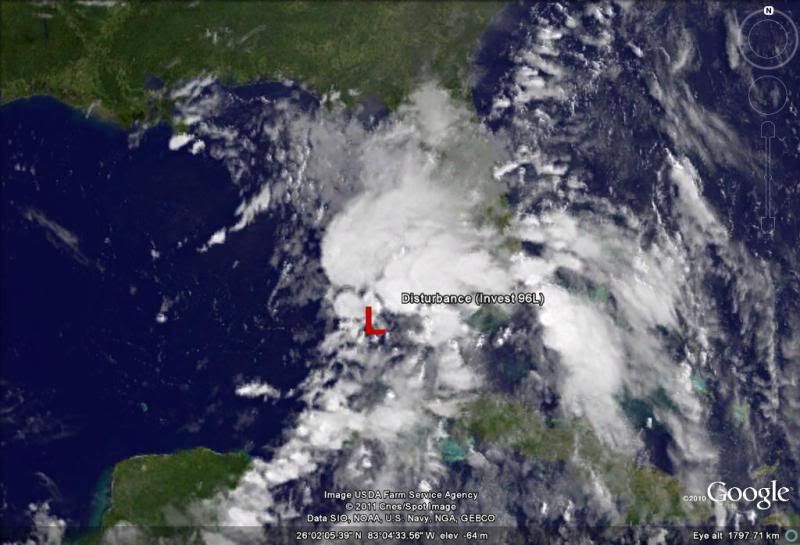
As the vis sat pics keep coming in we can clearly see the closed circulation, but it appears to me that the low pressure center might be a little bit further west than 12z NHC position.
Broad low pressure area, I would say centered near 25N & 84.5W, IMO.
0 likes


Who is online
Users browsing this forum: No registered users and 94 guests