

Off of Jacksonville:
BEGIN
NHC_ATCF
invest_al982011.invest
FSTDA
R
U
040
010
0000
201107161734
NONE
NOTIFY=ATRP
END
INVEST, AL, L, , , , , 98, 2011, DB, O, 2011071618, 9999999999, , , , , , METWATCH, , AL982011
AL, 98, 2011071518, , BEST, 0, 313N, 804W, 20, 1015, DB, 0, , 0, 0, 0, 0,
AL, 98, 2011071600, , BEST, 0, 310N, 800W, 20, 1015, DB, 0, , 0, 0, 0, 0,
AL, 98, 2011071606, , BEST, 0, 307N, 797W, 20, 1014, DB, 0, , 0, 0, 0, 0,
AL, 98, 2011071612, , BEST, 0, 304N, 794W, 20, 1014, DB, 0, , 0, 0, 0, 0,
AL, 98, 2011071618, , BEST, 0, 300N, 791W, 20, 1014, DB, 34, NEQ, 0, 0, 0, 0, 1016, 175, 90, 0, 0, L, 0, , 0, 0, INVEST, S,
ATL: BRET - Remnants - Discussion
Moderator: S2k Moderators

-
Hurricaneman

- Category 5

- Posts: 7282
- Age: 43
- Joined: Tue Aug 31, 2004 3:24 pm
- Location: central florida
-
cycloneye

- Admin

- Posts: 139127
- Age: 67
- Joined: Thu Oct 10, 2002 10:54 am
- Location: San Juan, Puerto Rico
Re: ATL: Invest 98L
TROPICAL WEATHER OUTLOOK
NWS NATIONAL HURRICANE CENTER MIAMI FL
200 PM EDT SAT JUL 16 2011
FOR THE NORTH ATLANTIC...CARIBBEAN SEA AND THE GULF OF MEXICO...
A SURFACE TROUGH ASSOCIATED WITH A WEAKENING FRONTAL SYSTEM IS
PRODUCING WIDESPREAD CLOUDINESS AND SHOWERS FROM THE NORTHEASTERN
FLORIDA AND GEORGIA COASTS EASTWARD OVER THE ATLANTIC OCEAN FOR
SEVERAL HUNDRED MILES. UPPER-LEVEL WINDS ARE ONLY MARGINALLY
CONDUCIVE FOR DEVELOPMENT...BUT COULD BECOME A LITTLE MORE
FAVORABLE DURING THE NEXT DAY OR TWO. THIS SYSTEM HAS A LOW
CHANCE...20 PERCENT...OF BECOMING A TROPICAL CYCLONE DURING THE
NEXT 48 HOURS AS IT MOVES SLOWLY TOWARD THE SOUTHEAST OR SOUTH.
ELSEWHERE...TROPICAL CYCLONE FORMATION IS NOT EXPECTED DURING THE
NEXT 48 HOURS.
$$
FORECASTER STEWART
0 likes
Visit the Caribbean-Central America Weather Thread where you can find at first post web cams,radars
and observations from Caribbean basin members Click Here
and observations from Caribbean basin members Click Here

-
cycloneye
- Admin
- Posts: 139127
- Age: 67
- Joined: Thu Oct 10, 2002 10:54 am
- Location: San Juan, Puerto Rico
Re: ATL: Invest 98L Models
Code: Select all
WHXX01 KWBC 161737
CHGHUR
TROPICAL CYCLONE GUIDANCE MESSAGE
NWS NATIONAL HURRICANE CENTER MIAMI FL
1737 UTC SAT JUL 16 2011

DISCLAIMER...NUMERICAL MODELS ARE SUBJECT TO LARGE ERRORS.
PLEASE REFER TO NHC OFFICIAL FORECASTS FOR TROPICAL CYCLONE
AND SUBTROPICAL CYCLONE INFORMATION.

ATLANTIC OBJECTIVE AIDS FOR

DISTURBANCE INVEST (AL982011) 20110716 1800 UTC

        ...00 HRS...   ...12 HRS...   ...24 HRS. ..   ...36 HRS...
        110716  1800   110717  0600   110717  1800   110718  0600

         LAT    LON     LAT    LON     LAT    LON     LAT    LON
BAMS    30.0N  79.1W   29.9N  79.8W   29.7N  80.8W   29.4N  82.0W
BAMD    30.0N  79.1W   29.4N  79.0W   28.6N  79.4W   27.8N  80.1W
BAMM    30.0N  79.1W   29.7N  79.6W   29.2N  80.3W   28.5N  81.4W
LBAR    30.0N  79.1W   29.6N  79.0W   29.8N  79.5W   30.7N  80.0W
SHIP        20KTS          24KTS          27KTS          30KTS
DSHP        20KTS          24KTS          27KTS          26KTS

        ...48 HRS...   ...72 HRS...   ...96 HRS. ..   ..120 HRS...
        110718  1800   110719  1800   110720  1800   110721  1800

         LAT    LON     LAT    LON     LAT    LON     LAT    LON
BAMS    29.1N  83.3W   28.2N  85.2W   27.7N  86.2W   27.9N  86.6W
BAMD    27.3N  81.1W   26.7N  83.5W   26.6N  85.9W   27.2N  88.4W
BAMM    28.0N  82.6W   27.2N  84.9W   27.0N  86.3W   27.3N  87.3W
LBAR    31.6N  80.9W   33.0N  82.2W   33.5N  80.4W   34.8N  76.9W
SHIP        33KTS          35KTS          36KTS          35KTS
DSHP        26KTS          32KTS          33KTS          32KTS

         ...INITIAL CONDITIONS...
LATCUR =  30.0N LONCUR =  79.1W DIRCUR = 140DEG SPDCUR =   5KT
LATM12 =  30.7N LONM12 =  79.7W DIRM12 = 139DEG SPDM12 =   4KT
LATM24 =  31.3N LONM24 =  80.4W
WNDCUR =   20KT RMAXWD =   90NM WNDM12 =   20KT
CENPRS = 1014MB OUTPRS = 1016MB OUTRAD =  175NM SDEPTH =   S
RD34NE =    0NM RD34SE =    0NM RD34SW =    0NM RD34NW =   0NM

0 likes
Visit the Caribbean-Central America Weather Thread where you can find at first post web cams,radars
and observations from Caribbean basin members Click Here
and observations from Caribbean basin members Click Here
-
northjaxpro

- S2K Supporter

- Posts: 8900
- Joined: Mon Sep 27, 2010 11:21 am
- Location: Jacksonville, FL
As of current, 98L is approximately 100 miles east of Jacksonville Beach.
0 likes
NEVER, EVER SAY NEVER in the tropics and weather in general, and most importantly, with life itself!!
________________________________________________________________________________________
Fay 2008 Beryl 2012 Debby 2012 Colin 2016 Hermine 2016 Julia 2016 Matthew 2016 Irma 2017 Dorian 2019
________________________________________________________________________________________
Fay 2008 Beryl 2012 Debby 2012 Colin 2016 Hermine 2016 Julia 2016 Matthew 2016 Irma 2017 Dorian 2019
-
Aric Dunn
- Category 5
- Posts: 21228
- Age: 41
- Joined: Sun Sep 19, 2004 9:58 pm
- Location: Ready for the Chase.
- Contact:
Close up sat loop. not a floater but until we get one it will work.
http://www.ssd.noaa.gov/goes/east/se/flash-rgb.html
http://www.ssd.noaa.gov/goes/east/se/flash-rgb.html
0 likes
Note: If I make a post that is brief. Please refer back to previous posts for the analysis or reasoning. I do not re-write/qoute what my initial post said each time.
If there is nothing before... then just ask
Space & Atmospheric Physicist, Embry-Riddle Aeronautical University,
I believe the sky is falling...
If there is nothing before... then just ask
Space & Atmospheric Physicist, Embry-Riddle Aeronautical University,
I believe the sky is falling...
-
Weatherfreak000
Re: ATL: INVEST 98L - Discussion
I like development chances here, and 20% immediately from NHC is pretty nice as well.
Is this still supposed to migrate to the GOM?
Is this still supposed to migrate to the GOM?
0 likes
-
Hurricaneman
- Category 5
- Posts: 7282
- Age: 43
- Joined: Tue Aug 31, 2004 3:24 pm
- Location: central florida
Re: ATL: INVEST 98L - Discussion
Weatherfreak000 wrote:I like development chances here, and 20% immediately from NHC is pretty nice as well.
Is this still supposed to migrate to the GOM?
yes and if the models are correct parts of Texas will get some needed rain
0 likes
-
Aric Dunn
- Category 5
- Posts: 21228
- Age: 41
- Joined: Sun Sep 19, 2004 9:58 pm
- Location: Ready for the Chase.
- Contact:
Re: ATL: INVEST 98L - Discussion
Weatherfreak000 wrote:I like development chances here, and 20% immediately from NHC is pretty nice as well.
Is this still supposed to migrate to the GOM?
depends on how far south the MLC drops south and if we get a second low form farther east. among other things
0 likes
Note: If I make a post that is brief. Please refer back to previous posts for the analysis or reasoning. I do not re-write/qoute what my initial post said each time.
If there is nothing before... then just ask
Space & Atmospheric Physicist, Embry-Riddle Aeronautical University,
I believe the sky is falling...
If there is nothing before... then just ask
Space & Atmospheric Physicist, Embry-Riddle Aeronautical University,
I believe the sky is falling...
-
Weatherfreak000
-
northjaxpro
- S2K Supporter
- Posts: 8900
- Joined: Mon Sep 27, 2010 11:21 am
- Location: Jacksonville, FL
Re: ATL: INVEST 98L - Discussion
NHC is stating that 98L will just drift and meander south in the short term. The GFS run earlier has 98L moving very slowly toward the FL coast up to 72 hours. But that was earlier today.
Much will be in the details in future model runs. 98L looks to meander around at least through the weekend just off the NE FL coast.
Much will be in the details in future model runs. 98L looks to meander around at least through the weekend just off the NE FL coast.
0 likes
NEVER, EVER SAY NEVER in the tropics and weather in general, and most importantly, with life itself!!
________________________________________________________________________________________
Fay 2008 Beryl 2012 Debby 2012 Colin 2016 Hermine 2016 Julia 2016 Matthew 2016 Irma 2017 Dorian 2019
________________________________________________________________________________________
Fay 2008 Beryl 2012 Debby 2012 Colin 2016 Hermine 2016 Julia 2016 Matthew 2016 Irma 2017 Dorian 2019
-
Weatherfreak000
-
CYCLONE MIKE
- Category 5
- Posts: 2183
- Joined: Tue Aug 31, 2004 6:04 pm
- Location: Gonzales, LA
Re: ATL: INVEST 98L - Discussion
Could be wrong, but thought I read in some areas discussion earlier stating if a low were to form it would move west for a day or two then turn NE.
0 likes
-
dixiebreeze
- S2K Supporter
- Posts: 5140
- Joined: Wed Sep 03, 2003 5:07 pm
- Location: crystal river, fla.
ATL: BRET - Recon
Plan of the Day
--------------------------------------------------------------------------------
000
NOUS42 KNHC 161715
WEATHER RECONNAISSANCE FLIGHTS
CARCAH, NATIONAL HURRICANE CENTER, MIAMI, FL.
115 PM EDT SAT 16 JULY 2011
SUBJECT: TROPICAL CYCLONE PLAN OF THE DAY (TCPOD)
VALID 17/1100Z TO 18/1100Z JULY 2011
TCPOD NUMBER.....11-046
I. ATLANTIC REQUIREMENTS
1. SUSPECT AREA
FLIGHT ONE -- TEAL 70
A. 17/1800Z
B. AFXXX 01BBA INVEST
C. 17/1615Z
D. 29.2N 78.6W
E. 17/1815Z TO 17/2345Z
F. SFC TO 10,000 FT
FLIGHT TWO -- TEAL 71
A. 18/0600
B. AFXXX 0202A CYCLONE
C. 18/0300Z
D. 29.0N 78.5W
E. 18/0500Z TO 18/0900Z
F. SFC TO 10,000 FT
2. OUTLOOK FOR SUCCEEDING DAY: CONTINUE 12-HRLY
FIXES WHILE SYSTEM REMAINS A THREAT.
0 likes
-
Rgv20

- S2K Supporter
- Posts: 2456
- Age: 37
- Joined: Wed Jan 05, 2011 5:42 pm
- Location: Edinburg/McAllen Tx
17zRuc has the 500mb vorticity moving south thru 18hrs.
Ruc Initialize
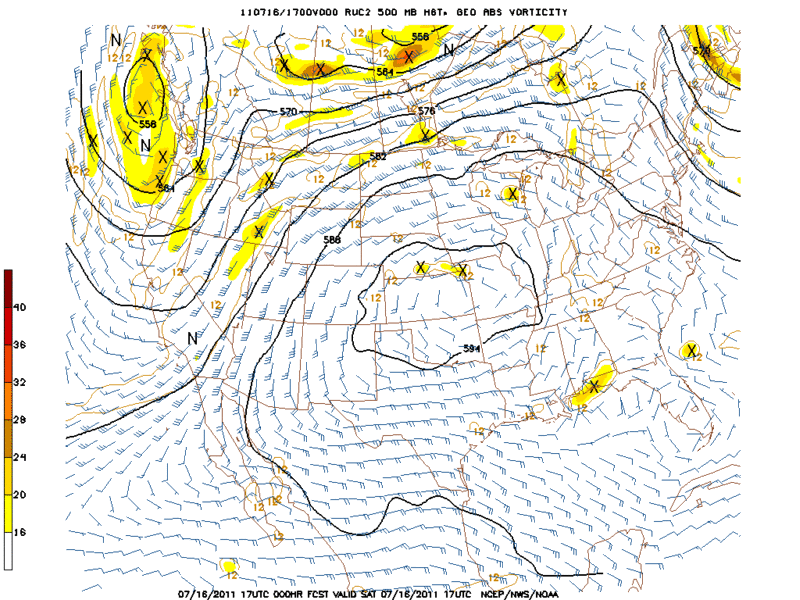
Forecast for 18hrs.
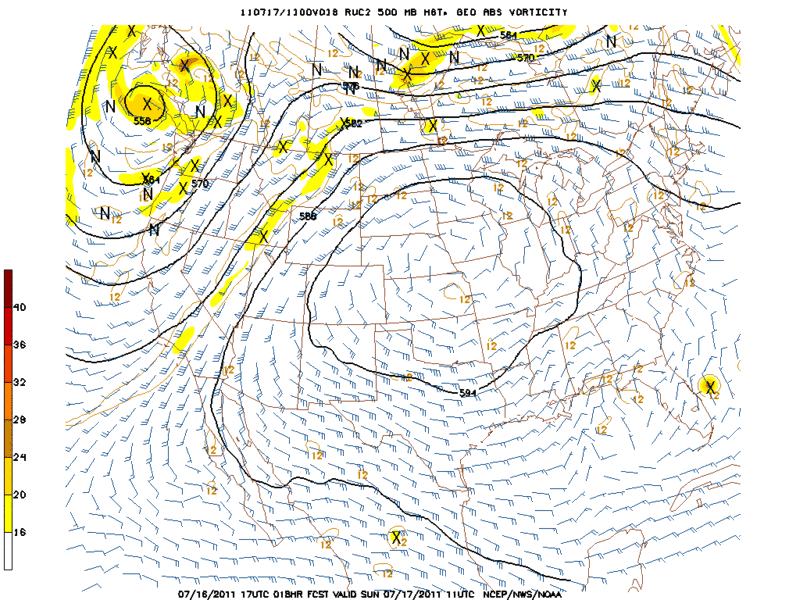
Thought I would look at the RUC since the global models did not initialize the invest that well.
Ruc Initialize
Forecast for 18hrs.
Thought I would look at the RUC since the global models did not initialize the invest that well.
0 likes
The following post is NOT an official forecast and should not be used as such. It is just the opinion of the poster and may or may not be backed by sound meteorological data. It is NOT endorsed by any professional institution including storm2k.org For Official Information please refer to the NHC and NWS products.
-
dixiebreeze
- S2K Supporter
- Posts: 5140
- Joined: Wed Sep 03, 2003 5:07 pm
- Location: crystal river, fla.
Who is online
Users browsing this forum: No registered users and 51 guests