ATL: INVEST 99L - Discussion
Moderator: S2k Moderators
-
MGC

- S2K Supporter

- Posts: 5792
- Joined: Sun Mar 23, 2003 9:05 pm
- Location: Pass Christian MS, or what is left.
Re: ATL: INVEST 99L - Discussion
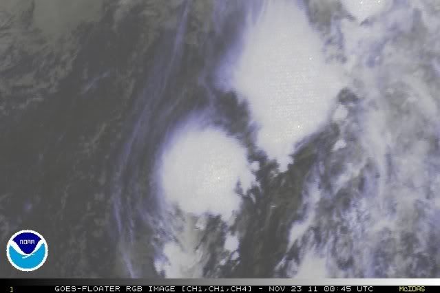
40KTS....enough convection near the center for an upgrade?....I think so...MGC
0 likes
-
cycloneye

- Admin

- Posts: 139027
- Age: 67
- Joined: Thu Oct 10, 2002 10:54 am
- Location: San Juan, Puerto Rico
Re:
Extratropical94 wrote:Well if it does develop into a storm and the September low being discussed on the board is upgraded post-seasonal, would the unnamed storm also count towards the poll?
Only named storms count for the poll, so if Tammy forms from this,#49 StormingB81 would be the solo winner with 19/7/3.
0 likes
Visit the Caribbean-Central America Weather Thread where you can find at first post web cams,radars
and observations from Caribbean basin members Click Here
and observations from Caribbean basin members Click Here
Re: ATL: INVEST 99L - Discussion
ZCZC MIATWOAT ALL
TTAA00 KNHC DDHHMM
TROPICAL WEATHER OUTLOOK
NWS NATIONAL HURRICANE CENTER MIAMI FL
700 PM EST MON NOV 21 2011
FOR THE NORTH ATLANTIC...CARIBBEAN SEA AND THE GULF OF MEXICO...
1. AN AREA OF LOW PRESSURE LOCATED ABOUT 900 MILES EAST OF BERMUDA
CONTINUES TO PRODUCE GALE-FORCE WINDS. WHILE THIS SYSTEM HAS
CHANGED LITTLE IN ORGANIZATION DURING THE PAST FEW HOURS AND STILL
HAS SOME FRONTAL CHARACTERISTICS...IT IS FORECAST TO INTENSIFY
DURING THE NEXT COUPLE OF DAYS AS EITHER A FRONTAL LOW OR A
SUBTROPICAL CYCLONE. THIS SYSTEM HAS A HIGH CHANCE...60 PERCENT...
OF BECOMING A SUBTROPICAL CYCLONE DURING THE NEXT 48 HOURS AS IT
MOVES NORTH-NORTHEASTWARD TO NORTHEASTWARD AT 10 TO 15 MPH.
ADDITIONAL INFORMATION ON THIS SYSTEM CAN BE FOUND IN HIGH SEAS
FORECASTS ISSUED BY THE NATIONAL WEATHER SERVICE...UNDER AWIPS
HEADER NFDHSFAT1 AND WMO HEADER FZNT01 KWBC.
ELSEWHERE...TROPICAL CYCLONE FORMATION IS NOT EXPECTED DURING THE
NEXT 48 HOURS.
$$
FORECASTER BRENNAN/BERG
NNNN
0 likes
All posts by Dean_175 are NOT official forecasts and should not be used as such. They are just the opinion of the poster and may or may not be backed by sound meteorological data. They are NOT endorsed by any professional institution or storm2k.org. For official information, please refer to the NHC and NWS products.
Re: ATL: INVEST 99L - Discussion
Dean_175 wrote:ZCZC MIATWOAT ALL
TTAA00 KNHC DDHHMM
TROPICAL WEATHER OUTLOOK
NWS NATIONAL HURRICANE CENTER MIAMI FL
700 PM EST MON NOV 21 2011
FOR THE NORTH ATLANTIC...CARIBBEAN SEA AND THE GULF OF MEXICO...
1. AN AREA OF LOW PRESSURE LOCATED ABOUT 900 MILES EAST OF BERMUDA
CONTINUES TO PRODUCE GALE-FORCE WINDS. WHILE THIS SYSTEM HAS
CHANGED LITTLE IN ORGANIZATION DURING THE PAST FEW HOURS AND STILL
HAS SOME FRONTAL CHARACTERISTICS...IT IS FORECAST TO INTENSIFY
DURING THE NEXT COUPLE OF DAYS AS EITHER A FRONTAL LOW OR A
SUBTROPICAL CYCLONE. THIS SYSTEM HAS A HIGH CHANCE...60 PERCENT...
OF BECOMING A SUBTROPICAL CYCLONE DURING THE NEXT 48 HOURS AS IT
MOVES NORTH-NORTHEASTWARD TO NORTHEASTWARD AT 10 TO 15 MPH.
ADDITIONAL INFORMATION ON THIS SYSTEM CAN BE FOUND IN HIGH SEAS
FORECASTS ISSUED BY THE NATIONAL WEATHER SERVICE...UNDER AWIPS
HEADER NFDHSFAT1 AND WMO HEADER FZNT01 KWBC.
ELSEWHERE...TROPICAL CYCLONE FORMATION IS NOT EXPECTED DURING THE
NEXT 48 HOURS.
$$
FORECASTER BRENNAN/BERG
NNNN
How is it frontal? I don't see an associated cold/warm front on an analysis chart? Can someone please answer this
0 likes
All posts by Dean_175 are NOT official forecasts and should not be used as such. They are just the opinion of the poster and may or may not be backed by sound meteorological data. They are NOT endorsed by any professional institution or storm2k.org. For official information, please refer to the NHC and NWS products.

Re: ATL: INVEST 99L - Discussion
1. SURFACE OBSERVATIONS NEAR THE LOW PRESSURE AREA LOCATED ABOUT
1000 MILES EAST-SOUTHEAST OF BERMUDA INDICATES THAT THIS SYSTEM
CONTINUES TO OBTAIN FRONTAL CHARACTERISTICS. THE LOW IS LIKELY TO
STRENGTHEN AS AN EXTRATROPICAL CYCLONE AND CONTINUE PRODUCING GALE
FORCE WINDS AS IT MOVES NORTHEASTWARD DURING THE NEXT COUPLE OF
DAYS. THIS SYSTEM HAS A LOW CHANCE...10 PERCENT...OF BECOMING A
SUBTROPICAL CYCLONE DURING THE NEXT 48 HOURS. ADDITIONAL
INFORMATION ON THIS LOW CAN BE FOUND IN HIGH SEAS FORECASTS ISSUED
BY THE NATIONAL WEATHER SERVICE...UNDER AWIPS HEADER NFDHSFAT1 AND
WMO HEADER FZNT01 KWBC.
There's always next year...
0 likes
-
ozonepete
- Professional-Met

- Posts: 4743
- Joined: Mon Sep 07, 2009 3:23 pm
- Location: From Ozone Park, NYC / Now in Brooklyn, NY
Re: ATL: INVEST 99L - Discussion
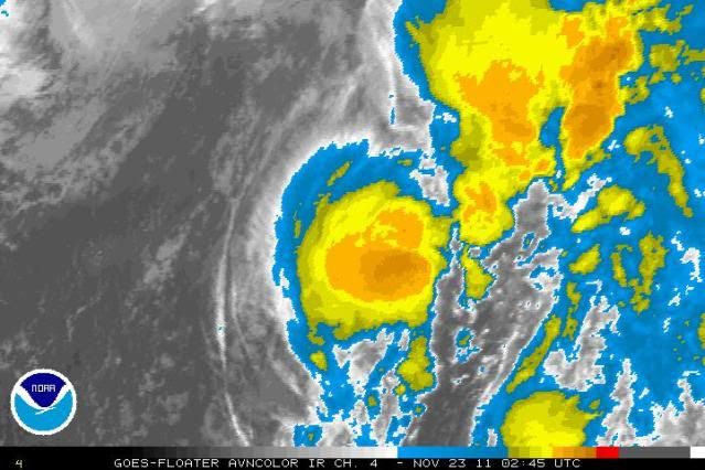
I think they're writing it off too soon. The circulation appears to be separating from the front and is still over marginally favorable SSTs. A circular area of convection is once again building over the LLC. This one has tenacity.
If there was ever a theme to this season it's had two parts:
1. Most systems that developed didn't become very strong.
2. A lot of disturbances this year were not expected to develop into named storms, but did anyway.
This one is following both rules. I think this will get named. If not in the next 2 days, then after the season is over.
0 likes
-
ozonepete
- Professional-Met
- Posts: 4743
- Joined: Mon Sep 07, 2009 3:23 pm
- Location: From Ozone Park, NYC / Now in Brooklyn, NY
Re: ATL: INVEST 99L - Discussion
BTW, notice how the low (where that ball of convection is) is behind the front. That would be really odd for such a low to survive and become tropical or subtropical. But that's the kind of season it's been. Very unusual development scenarios. For this to survive it has to go further east than north for now and stay separate fom the front which should dissipate.
(Notice it's developing some outflow cirrus, a more tropical characteristic.)
(Notice it's developing some outflow cirrus, a more tropical characteristic.)
0 likes
-
StormingB81

- S2K Supporter
- Posts: 5676
- Age: 42
- Joined: Thu Aug 27, 2009 1:45 am
- Location: Rockledge, Florida
-
ozonepete
- Professional-Met
- Posts: 4743
- Joined: Mon Sep 07, 2009 3:23 pm
- Location: From Ozone Park, NYC / Now in Brooklyn, NY
Re: ATL: INVEST 99L - Discussion
I think you're talking about this forecast image they put out, right? It's actually a forecast for 18Z on November 21st, which was Monday afternoon. I think that's an old forecast and they have just not updated it since the NHC dropped the possibility from 60% to 10%.
0 likes
-
ozonepete
- Professional-Met
- Posts: 4743
- Joined: Mon Sep 07, 2009 3:23 pm
- Location: From Ozone Park, NYC / Now in Brooklyn, NY
Re: ATL: INVEST 99L - Discussion
Really unusual, hybrid kind of system. It looks like the low is maintaining a circular, very tropical like configuration while the front is moving out ahead of it. While I wouldn't think it should develop given the ongoing conditions, I'm not sure, and am very curious how this will pan out. It certainly looks more tropical than it did earlier today.
0 likes
-
Epsilon_Fan

- Category 1

- Posts: 353
- Joined: Fri Jan 13, 2006 1:03 pm
- Location: Charleston, SC
Re: ATL: INVEST 99L - Discussion
how is this not on the Tropical outlook still? Just look at the recent loop, the convection is around the center and the circulation is still tight. Certainly doesn't look like a typical extratropical low yet.
0 likes
-
Chickenzilla
- Tropical Storm

- Posts: 109
- Joined: Wed Oct 19, 2011 7:31 am
- Location: Croatia (Southeast Europe)

-
cycloneye
- Admin
- Posts: 139027
- Age: 67
- Joined: Thu Oct 10, 2002 10:54 am
- Location: San Juan, Puerto Rico
Re: ATL: INVEST 99L - Discussion
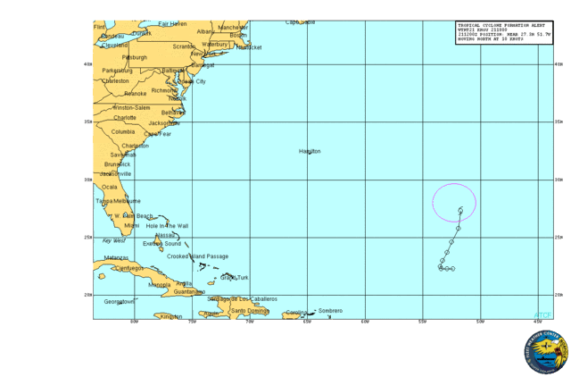
SSD dvorak is still releasing numbers as ST.
23/1145 UTC 31.9N 39.7W ST1.5 99L
23/1145 UTC 31.9N 39.7W ST1.5 99L
0 likes
Visit the Caribbean-Central America Weather Thread where you can find at first post web cams,radars
and observations from Caribbean basin members Click Here
and observations from Caribbean basin members Click Here
-
cycloneye
- Admin
- Posts: 139027
- Age: 67
- Joined: Thu Oct 10, 2002 10:54 am
- Location: San Juan, Puerto Rico
Re: ATL: INVEST 99L - Discussion
NHC mentions it again.
TROPICAL WEATHER OUTLOOK
NWS NATIONAL HURRICANE CENTER MIAMI FL
700 PM EST WED NOV 23 2011
FOR THE NORTH ATLANTIC...CARIBBEAN SEA AND THE GULF OF MEXICO...
SATELLITE DATA THIS EVENING INDICATE THAT SHOWER ACTIVITY HAS
INCREASED NEAR THE CENTER OF A LOW PRESSURE AREA CENTERED ABOUT
500 MILES SOUTHWEST OF THE AZORES...AND THAT STRONG WINDS ASSOCIATED
WITH THE LOW HAVE BECOME MORE CONCENTRATED NEAR THE CENTER.
HOWEVER...THE LOW HAS WELL-DEFINED FRONTS...AND ENVIRONMENTAL
CONDITIONS ARE NOT CURRENTLY FAVORABLE FOR SUBTROPICAL CYCLONE
DEVELOPMENT. THIS SYSTEM HAS A LOW CHANCE...NEAR 0 PERCENT...OF
BECOMING A SUBTROPICAL CYCLONE DURING THE NEXT 48 HOURS.
ELSEWHERE...TROPICAL CYCLONE FORMATION IS NOT EXPECTED DURING THE
NEXT 48 HOURS.
$$
FORECASTER BEVEN
0 likes
Visit the Caribbean-Central America Weather Thread where you can find at first post web cams,radars
and observations from Caribbean basin members Click Here
and observations from Caribbean basin members Click Here
-
Epsilon_Fan
- Category 1
- Posts: 353
- Joined: Fri Jan 13, 2006 1:03 pm
- Location: Charleston, SC
Re: ATL: INVEST 99L - Discussion
well, it looks frontal/extratropical now, but 24 hours ago it looked hybrid or subtropical 
0 likes
Who is online
Users browsing this forum: No registered users and 65 guests