https://x.com/MrJamesCosgrove/status/1946161440747892770
WPAC: WIPHA - Tropical Storm - Discussion
Moderators: S2k Moderators, WesternPacificWeatherMods
Forum rules

The posts in this forum are NOT official forecast and should not be used as such. They are just the opinion of the poster and may or may not be backed by sound meteorological data. They are NOT endorsed by any professional institution or STORM2K.
-
cycloneye

- Admin

- Posts: 145322
- Age: 68
- Joined: Thu Oct 10, 2002 10:54 am
- Location: San Juan, Puerto Rico
Re: WPAC: WIPHA - Tropical Storm - Discussion
0 likes
Visit the Caribbean-Central America Weather Thread where you can find at first post web cams,radars
and observations from Caribbean basin members Click Here
and observations from Caribbean basin members Click Here

Re: WPAC: WIPHA - Tropical Storm - Discussion
JTWC finally upgrades
09W WIPHA 250718 1200 19.3N 122.5E WPAC 35 991
1 likes
ヤンデレ女が寝取られるているのを見たい!!!
ECMWF ensemble NWPAC plots: https://ecmwfensnwpac.imgbb.com/
Multimodel NWPAC plots: https://multimodelnwpac.imgbb.com/
GFS Ensemble NWPAC plots (16 & 35 day forecast): https://gefsnwpac.imgbb.com/
Plots updated automatically
ECMWF ensemble NWPAC plots: https://ecmwfensnwpac.imgbb.com/
Multimodel NWPAC plots: https://multimodelnwpac.imgbb.com/
GFS Ensemble NWPAC plots (16 & 35 day forecast): https://gefsnwpac.imgbb.com/
Plots updated automatically
-
cycloneye
- Admin
- Posts: 145322
- Age: 68
- Joined: Thu Oct 10, 2002 10:54 am
- Location: San Juan, Puerto Rico
Re: WPAC: WIPHA - Tropical Storm - Discussion
0 likes
Visit the Caribbean-Central America Weather Thread where you can find at first post web cams,radars
and observations from Caribbean basin members Click Here
and observations from Caribbean basin members Click Here
-
sasha_B

- Tropical Depression

- Posts: 81
- Age: 24
- Joined: Sun Jun 30, 2024 4:32 pm
- Location: Charleston, SC
Re: WPAC: WIPHA - Tropical Storm - Discussion
First JTWC satellite fix is 3.0/3.0 and remarks note rapid strengthening:
H. REMARKS: 38A/PBO SBC/ANMTN. CNVCTN WRAPS .70 ON LOG10 SPIRAL
YIELDING A DT OF 3.0. MET YIELDS 2.5. PT AGREES WITH DT. DBO DT.
BROKE CONSTRAINTS OF MORE THAN 0.5 T# CHANGE PER 6 HOURS DUE TO
RAPID STRENGTHENING. INTENSITY ESTIMATE MAY NOT BE REPRESENTATIVE
DUE TO PROXIMITY TO LAND.
YIELDING A DT OF 3.0. MET YIELDS 2.5. PT AGREES WITH DT. DBO DT.
BROKE CONSTRAINTS OF MORE THAN 0.5 T# CHANGE PER 6 HOURS DUE TO
RAPID STRENGTHENING. INTENSITY ESTIMATE MAY NOT BE REPRESENTATIVE
DUE TO PROXIMITY TO LAND.
0 likes
-
sasha_B
- Tropical Depression
- Posts: 81
- Age: 24
- Joined: Sun Jun 30, 2024 4:32 pm
- Location: Charleston, SC
Re: WPAC: WIPHA - Tropical Storm - Discussion
As of 18z, the latest manual Dvorak fixes are 3.5 from JTWC and 3.0 from NOAA/OSPO, while ADT is up to 2.9 (constrained) with recent raw T #s between 3.3~3.6. Best Track is 45 knots, 984 hPa. So far, at least, Wipha has been intensifying more quickly than was forecast.
09W WIPHA 250718 1800 19.8N 120.8E WPAC 45 984
0 likes
-
cycloneye
- Admin
- Posts: 145322
- Age: 68
- Joined: Thu Oct 10, 2002 10:54 am
- Location: San Juan, Puerto Rico
Re: WPAC: WIPHA - Tropical Storm - Discussion
A. 09W (WIPHA)
B. 18/2330Z
C. 20.3N
D. 119.9E
E. THREE/HIMAWARI-9
F. T3.5/3.5
G. IR/EIR/VIS/SSMIS
H. REMARKS...POSITION BASED IN PART ON RECENT SSMIS DATA THAT SHOWED A
BANDING EYE AT 37 GHZ. 8/10 BANDING YIELDS A DT OF 3.5. PT AGREES. MET
IS ALSO 3.5 BASED ON A 24 HOUR RAPID DEVELOPMENT TREND. THE FT IS BASED
ON THE DT.
I. ADDL POSITIONS
18/2210Z 20.3N 119.9E SSMIS
...TURK
1 likes
Visit the Caribbean-Central America Weather Thread where you can find at first post web cams,radars
and observations from Caribbean basin members Click Here
and observations from Caribbean basin members Click Here
-
cycloneye
- Admin
- Posts: 145322
- Age: 68
- Joined: Thu Oct 10, 2002 10:54 am
- Location: San Juan, Puerto Rico
Re: WPAC: WIPHA - Tropical Storm - Discussion

0 likes
Visit the Caribbean-Central America Weather Thread where you can find at first post web cams,radars
and observations from Caribbean basin members Click Here
and observations from Caribbean basin members Click Here
-
mrbagyo

- Category 5

- Posts: 3719
- Age: 33
- Joined: Thu Apr 12, 2012 9:18 am
- Location: 14.13N 120.98E
- Contact:
Re: WPAC: WIPHA - Tropical Storm - Discussion
HKO is sending reconnaissance mission into Wipha. Just read about it from TYboard ( Chinese wx forum)
Checked flightradar and yes they really did

Checked flightradar and yes they really did
0 likes
The posts in this forum are NOT official forecast and should not be used as such. They are just the opinion of the poster and may or may not be backed by sound meteorological data. They are NOT endorsed by any professional institution or storm2k.org. For official information, please refer to RSMC, NHC and NWS products.
-
mrbagyo
- Category 5
- Posts: 3719
- Age: 33
- Joined: Thu Apr 12, 2012 9:18 am
- Location: 14.13N 120.98E
- Contact:
Re: WPAC: WIPHA - Tropical Storm - Discussion
Vortical hot towers rotating around the district LLC

2 likes
The posts in this forum are NOT official forecast and should not be used as such. They are just the opinion of the poster and may or may not be backed by sound meteorological data. They are NOT endorsed by any professional institution or storm2k.org. For official information, please refer to RSMC, NHC and NWS products.
-
Hurricane2022

- Category 5
- Posts: 1543
- Joined: Tue Aug 23, 2022 11:38 pm
- Location: Araçatuba, Brazil
Re: WPAC: WIPHA - Tropical Storm - Discussion
mrbagyo wrote:HKO is sending reconnaissance mission into Wipha. Just read about it from TYboard ( Chinese wx forum)
Checked flightradar and yes they really did
https://s14.gifyu.com/images/bKiqA.jpg
Any recent data from this? Did the aircraft penetrated the "eye"?
1 likes
Sorry for the bad English sometimes...!
For reliable and detailed information for any meteorological phenomenon, please consult the National Hurricane Center, Joint Typhoon Warning Center , or your local Meteo Center.
--------
Una cvm Christo, pro Christo, et in Christo. Sit nomen Domini benedictvm.
For reliable and detailed information for any meteorological phenomenon, please consult the National Hurricane Center, Joint Typhoon Warning Center , or your local Meteo Center.
--------
Una cvm Christo, pro Christo, et in Christo. Sit nomen Domini benedictvm.
-
mrbagyo
- Category 5
- Posts: 3719
- Age: 33
- Joined: Thu Apr 12, 2012 9:18 am
- Location: 14.13N 120.98E
- Contact:
Re: WPAC: WIPHA - Tropical Storm - Discussion
As posted on the other forum,
The plane only circled the outer rain bands, no gale force wind was measured. No center fix
The plane only circled the outer rain bands, no gale force wind was measured. No center fix
3 likes
The posts in this forum are NOT official forecast and should not be used as such. They are just the opinion of the poster and may or may not be backed by sound meteorological data. They are NOT endorsed by any professional institution or storm2k.org. For official information, please refer to RSMC, NHC and NWS products.
-
StormWeather

- Tropical Storm

- Posts: 128
- Joined: Wed Jun 05, 2024 2:34 pm
Re: WPAC: WIPHA - Tropical Storm - Discussion
mrbagyo wrote:As posted on the other forum,
The plane only circled the outer rain bands, no gale force wind was measured. No center fix
It’s a shame the JTWC doesn’t do recon here anymore, as recon would be a good way to resolve the intensities of all of those monstrous super typhoons and weaker storms too.
1 likes
Just your average cyclone tracker
Cyclones experienced;
Debby 24’
Cyclones experienced;
Debby 24’
-
cycloneye
- Admin
- Posts: 145322
- Age: 68
- Joined: Thu Oct 10, 2002 10:54 am
- Location: San Juan, Puerto Rico
Re: WPAC: WIPHA - Tropical Storm - Discussion
No mention of plane at discussion.
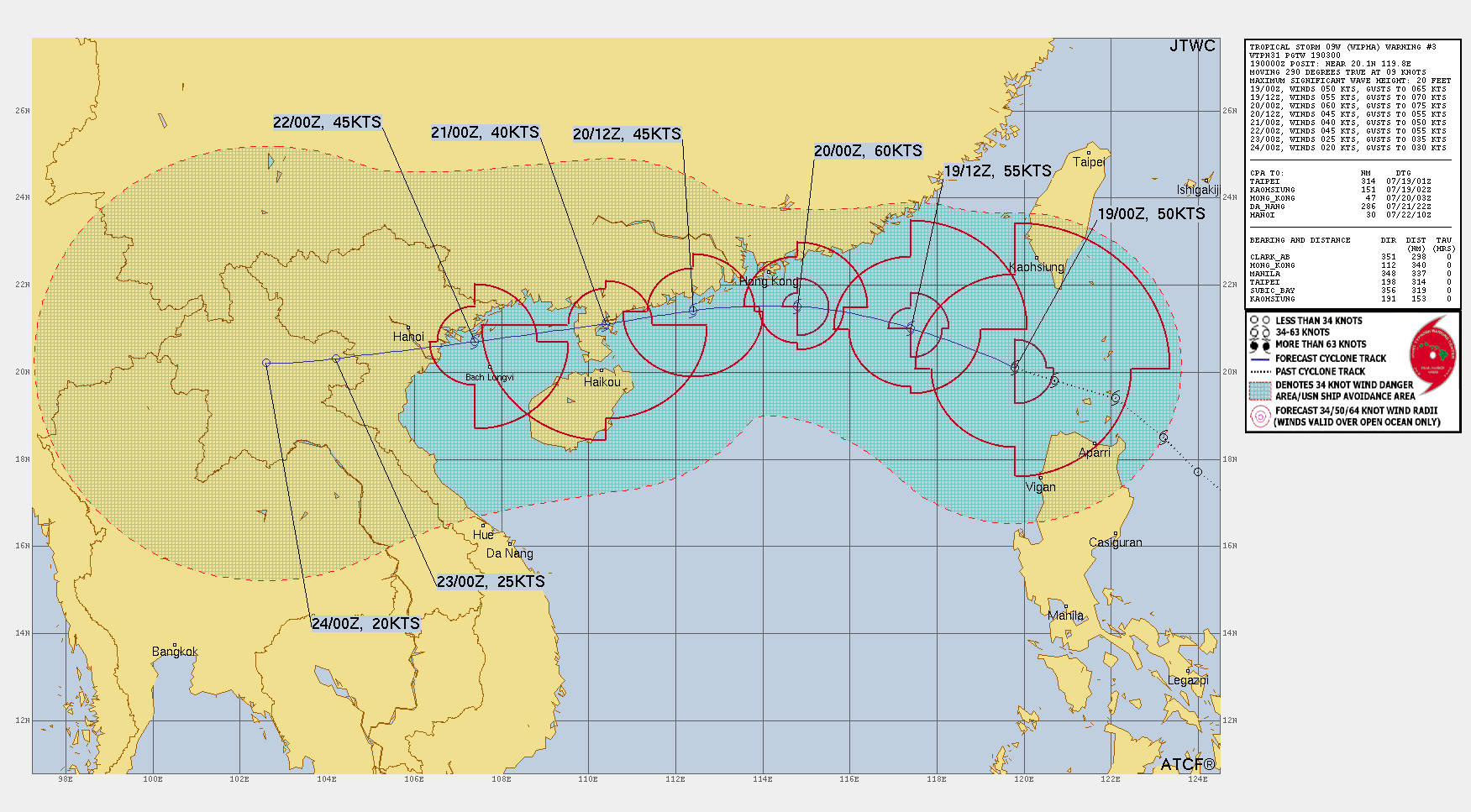
SUMMARY:
INITIAL POSITION: 21.0N 117.7E
INITIAL INTENSITY: 55 KTS
GEOGRAPHIC REFERENCE: 210 NM EAST-SOUTHEAST OF HONG KONG
MOVEMENT PAST 6 HOURS: WEST-NORTHWESTWARD AT 12 KTS
SIGNIFICANT WAVE HEIGHT: 24 FEET
SATELLITE ANALYSIS, INITIAL POSITION AND INTENSITY DISCUSSION:
ANIMATED ENHANCED INFRARED (EIR) SATELLITE IMAGERY REVEALS AN
OBSCURED LOW-LEVEL CIRCULATION CENTER (LLCC) EMBEDDED WITHIN CURVED
BANDS OF DEEP CONVECTIVE ACTIVITY ASSOCIATED WITH TROPICAL STORM
(TS) 09W (WIPHA). THE INITIAL POSITION IS ASSIGNED WITH HIGH
CONFIDENCE SUPPORTED BY A 191235Z METOP-B ASCAT PASS. THE INITIAL
INTENSITY ESTIMATE OF 55 KTS IS ALSO LAID WITH HIGH CONFIDENCE,
BASED ON A SYNTHESIS OF SUBJECTIVE DVORAK INTENSITY ESTIMATES FROM
MULTIPLE AGENCIES AND OBJECTIVE SATELLITE-DERIVED WIND PRODUCTS,
INCLUDING THE ABOVE-MENTIONED ASCAT DATA. ENVIRONMENTAL ANALYSIS
INDICATES A FAVORABLE SYNOPTIC SETUP CHARACTERIZED BY HIGH (29-30 C)
SEA SURFACE TEMPERATURES (SST), ABUNDANT TROPOSPHERIC MOISTURE, AS
WELL AS AN ENHANCED EQUATORWARD OUTFLOW EVIDENT IN WATER VAPOR
IMAGERY, INDICATIVE OF ROBUST UPPER-TROPOSPHERIC DIVERGENCE. THESE
POSITIVE PARAMETERS ARE PARTIALLY OFFSET BY MODERATE TO STRONG
(20-25 KTS) VERTICAL WIND SHEAR (VWS).
1 likes
Visit the Caribbean-Central America Weather Thread where you can find at first post web cams,radars
and observations from Caribbean basin members Click Here
and observations from Caribbean basin members Click Here
-
mrbagyo
- Category 5
- Posts: 3719
- Age: 33
- Joined: Thu Apr 12, 2012 9:18 am
- Location: 14.13N 120.98E
- Contact:
Re: WPAC: WIPHA - Tropical Storm - Discussion
HKO upgrades Wipha into typhoon status
0 likes
The posts in this forum are NOT official forecast and should not be used as such. They are just the opinion of the poster and may or may not be backed by sound meteorological data. They are NOT endorsed by any professional institution or storm2k.org. For official information, please refer to RSMC, NHC and NWS products.
-
cycloneye
- Admin
- Posts: 145322
- Age: 68
- Joined: Thu Oct 10, 2002 10:54 am
- Location: San Juan, Puerto Rico
Re: WPAC: WIPHA - Tropical Storm - Discussion
1 likes
Visit the Caribbean-Central America Weather Thread where you can find at first post web cams,radars
and observations from Caribbean basin members Click Here
and observations from Caribbean basin members Click Here
-
sasha_B
- Tropical Depression
- Posts: 81
- Age: 24
- Joined: Sun Jun 30, 2024 4:32 pm
- Location: Charleston, SC
Re: WPAC: WIPHA - Tropical Storm - Discussion
NOAA-OSPO has a 4.0 manual Dvorak fix; ADT is 3.8/4.1 with raw T#s higher because of a (possibly dubious) eye scene. JTWC satellite bulletin holds it at 3.5. Either way, the data support at least holding intensity at 55 kts / 976 hPa on the next advisories, if not going up slightly.
0 likes
Return to “Active Storms - WestPAC/Asia”
Who is online
Users browsing this forum: cycloneye and 2 guests