WPAC: KALMAEGI - Post-Tropical - Discussion

Detailed discussion and tracking of all WestPac basin storms with special input from staff of our partner site, WesternPacificWeather

Moderators: S2k Moderators, WesternPacificWeatherMods

Forum rules

The posts in this forum are NOT official forecast and should not be used as such. They are just the opinion of the poster and may or may not be backed by sound meteorological data. They are NOT endorsed by any professional institution or STORM2K.

Help Support Storm2K
Message
Author
User avatar
sasha_B
Category 1
Category 1
Posts: 258
Age: 24
Joined: Sun Jun 30, 2024 4:32 pm
Location: Charleston, SC

Re: WPAC: KALMAEGI - Typhoon - Discussion

#101 Postby sasha_B » Wed Nov 05, 2025 2:34 pm

Now 100 kts per JTWC:
31W KALMAEGI 251105 1800 13.2N 114.3E WPAC 100 960


...and 955 hPa per JMA.
0 likes   

User avatar
Hurricane2022
Category 5
Category 5
Posts: 1929
Joined: Tue Aug 23, 2022 11:38 pm
Location: Araçatuba, Brazil

Re: WPAC: KALMAEGI - Typhoon - Discussion

#102 Postby Hurricane2022 » Wed Nov 05, 2025 3:20 pm

-91°C :froze:
Image
Image
5 likes   
Sorry for the bad English sometimes...!
For reliable and detailed information for any meteorological phenomenon, please consult the National Hurricane Center, Joint Typhoon Warning Center , or your local Meteo Center.

--------

ECCE OMNIA NOVA FACIAM (Ap 21,5).

User avatar
sasha_B
Category 1
Category 1
Posts: 258
Age: 24
Joined: Sun Jun 30, 2024 4:32 pm
Location: Charleston, SC

Re: WPAC: KALMAEGI - Typhoon - Discussion

#103 Postby sasha_B » Wed Nov 05, 2025 3:24 pm


The uptick in ADT presentation was remarkable: raw T# jumped from 3.9 to 7.3 as soon as the center was correctly identified!
3 likes   

User avatar
Hurricane2022
Category 5
Category 5
Posts: 1929
Joined: Tue Aug 23, 2022 11:38 pm
Location: Araçatuba, Brazil

Re: WPAC: KALMAEGI - Typhoon - Discussion

#104 Postby Hurricane2022 » Wed Nov 05, 2025 3:32 pm

Moving really fast
Image
2 likes   

User avatar
cycloneye
Admin
Admin
Posts: 148418
Age: 69
Joined: Thu Oct 10, 2002 10:54 am
Location: San Juan, Puerto Rico

Re: WPAC: KALMAEGI - Typhoon - Discussion

#105 Postby cycloneye » Wed Nov 05, 2025 3:33 pm

Image
1 likes   
Visit the Caribbean-Central America Weather Thread where you can find at first post web cams,radars
and observations from Caribbean basin members Click Here

User avatar
mrbagyo
Category 5
Category 5
Posts: 3923
Age: 33
Joined: Thu Apr 12, 2012 9:18 am
Location: 14.13N 120.98E
Contact:

Re: WPAC: KALMAEGI - Typhoon - Discussion

#106 Postby mrbagyo » Wed Nov 05, 2025 4:43 pm

Image
Image
Image
2 likes   
The posts in this forum are NOT official forecast and should not be used as such. They are just the opinion of the poster and may or may not be backed by sound meteorological data. They are NOT endorsed by any professional institution or storm2k.org. For official information, please refer to RSMC, NHC and NWS products.

User avatar
cycloneye
Admin
Admin
Posts: 148418
Age: 69
Joined: Thu Oct 10, 2002 10:54 am
Location: San Juan, Puerto Rico

Re: WPAC: KALMAEGI - Typhoon - Discussion

#107 Postby cycloneye » Wed Nov 05, 2025 6:53 pm

0 likes   
Visit the Caribbean-Central America Weather Thread where you can find at first post web cams,radars
and observations from Caribbean basin members Click Here

User avatar
Teban54
Category 5
Category 5
Posts: 3751
Joined: Sat May 19, 2018 1:19 pm

Re: WPAC: KALMAEGI - Typhoon - Discussion

#108 Postby Teban54 » Wed Nov 05, 2025 7:32 pm

Image
1 likes   

User avatar
cycloneye
Admin
Admin
Posts: 148418
Age: 69
Joined: Thu Oct 10, 2002 10:54 am
Location: San Juan, Puerto Rico

Re: WPAC: KALMAEGI - Typhoon - Discussion

#109 Postby cycloneye » Wed Nov 05, 2025 8:06 pm

Cat 4.

31W KALMAEGI 251106 0000 13.2N 112.1E WPAC 115 948
1 likes   
Visit the Caribbean-Central America Weather Thread where you can find at first post web cams,radars
and observations from Caribbean basin members Click Here

User avatar
xtyphooncyclonex
Category 5
Category 5
Posts: 3888
Age: 24
Joined: Sat Dec 08, 2012 9:07 am
Location: Cebu City
Contact:

Re: WPAC: KALMAEGI - Typhoon - Discussion

#110 Postby xtyphooncyclonex » Wed Nov 05, 2025 8:23 pm

Per Cebu Provincial Government, and Cebu City Mayor's Office, total casualties in the province (and cities) of Cebu has reached 111.
1 likes   
REMINDER: My opinions that I, or any other NON Pro-Met in this forum, are unofficial. Please do not take my opinions as an official forecast and warning. I am NOT a meteorologist. Following my forecasts blindly may lead to false alarm, danger and risk if official forecasts from agencies are ignored.

User avatar
mrbagyo
Category 5
Category 5
Posts: 3923
Age: 33
Joined: Thu Apr 12, 2012 9:18 am
Location: 14.13N 120.98E
Contact:

Re: WPAC: KALMAEGI - Typhoon - Discussion

#111 Postby mrbagyo » Wed Nov 05, 2025 8:43 pm

The eyewall has started to manifest on Quy Nhon, Vietnam's radar.

Image
2 likes   
The posts in this forum are NOT official forecast and should not be used as such. They are just the opinion of the poster and may or may not be backed by sound meteorological data. They are NOT endorsed by any professional institution or storm2k.org. For official information, please refer to RSMC, NHC and NWS products.

User avatar
mrbagyo
Category 5
Category 5
Posts: 3923
Age: 33
Joined: Thu Apr 12, 2012 9:18 am
Location: 14.13N 120.98E
Contact:

Re: WPAC: KALMAEGI - Typhoon - Discussion

#112 Postby mrbagyo » Thu Nov 06, 2025 2:47 am

The eyewall appears to have collapsed just as it's approaching the coastal city of Quy Nhon (pop > 500,000)
0 likes   
The posts in this forum are NOT official forecast and should not be used as such. They are just the opinion of the poster and may or may not be backed by sound meteorological data. They are NOT endorsed by any professional institution or storm2k.org. For official information, please refer to RSMC, NHC and NWS products.

User avatar
mrbagyo
Category 5
Category 5
Posts: 3923
Age: 33
Joined: Thu Apr 12, 2012 9:18 am
Location: 14.13N 120.98E
Contact:

Re: WPAC: KALMAEGI - Typhoon - Discussion

#113 Postby mrbagyo » Thu Nov 06, 2025 5:07 am

AAXX 06091 48870 21465 87910 10250 20236 39912 49919 57066 76066 8572/ 333 59138 60347 85894 88499 91127 91522 96160

Station: QUY NHON (4 m - 13.767N - 109.217E)

Synop, reported by a manned station.

Day: 06/11/2025
Hour: 09 UTC

Air Temperature : +25.0ºC
Dew point: +23.6ºC
Air relative humidity: 91%

Station pressure: 991.2 Hpa
Sea level pressure: 991.9 Hpa
Pressure change: 6.6 Hpa, Decreasing steadily; resultant pressure lower
Surface pressure change in the last 24 hours: -13.8 Hpa

Wind direction: 785º-794º (north).
Wind speed: 10 m/s (36.0 Km/h), from anemometer.

Horizontal visibility: 15.0 kilometers.

Total cloud cover: 8 eighths
Height above ground of cloud base of lowest cloud seen : 300 to 600 m
Low clouds: stratus or cumulus fractus (bad weather). (Cover: 5 eighths).
Middle clouds: altostratus opacus or nimbostratus.
High clouds: unobserved due to darkness, obscuration or to a continuous cloud layer in a lower level.
Layer of cumulus (Cu) , height of cloud base from 300 to 600 m, cover: 5 eighths.
Layer of altostratus (As) , height of cloud base more than 2500 m, cover: 8 eighths.

Present weather: intermittent light rain.
Past weather: rain.

Precipitation: 34.0 mm in the last 3 hours.


SUPPLEMENTARY INFORMATION

Wind gust: 27 m/s (97.2 Km/h), from anemometer.
wind direction: 215º-224º (component souhwest).
Present weather: rain, falling speed less than 1,0 mm/h.
0 likes   
The posts in this forum are NOT official forecast and should not be used as such. They are just the opinion of the poster and may or may not be backed by sound meteorological data. They are NOT endorsed by any professional institution or storm2k.org. For official information, please refer to RSMC, NHC and NWS products.

User avatar
Hurricane2022
Category 5
Category 5
Posts: 1929
Joined: Tue Aug 23, 2022 11:38 pm
Location: Araçatuba, Brazil

Re: WPAC: KALMAEGI - Typhoon - Discussion

#114 Postby Hurricane2022 » Thu Nov 06, 2025 5:08 am

JMA had a 95kt/935 mb peak earlier. It's the third strongest storm this season so far, tied with Halong.
0 likes   
Sorry for the bad English sometimes...!
For reliable and detailed information for any meteorological phenomenon, please consult the National Hurricane Center, Joint Typhoon Warning Center , or your local Meteo Center.

--------

ECCE OMNIA NOVA FACIAM (Ap 21,5).

User avatar
mrbagyo
Category 5
Category 5
Posts: 3923
Age: 33
Joined: Thu Apr 12, 2012 9:18 am
Location: 14.13N 120.98E
Contact:

Re: WPAC: KALMAEGI - Typhoon - Discussion

#115 Postby mrbagyo » Thu Nov 06, 2025 5:16 am

Hurricane2022 wrote:JMA had a 95kt/935 mb peak earlier. It's the third strongest storm this season so far, tied with Halong.


12z SYNOP from Quy Nhon will determine if that 935 hPa estimate is high or not. Looks like the center will pass directly over the synoptic station
1 likes   
The posts in this forum are NOT official forecast and should not be used as such. They are just the opinion of the poster and may or may not be backed by sound meteorological data. They are NOT endorsed by any professional institution or storm2k.org. For official information, please refer to RSMC, NHC and NWS products.

User avatar
GCANE
S2K Supporter
S2K Supporter
Posts: 12042
Joined: Mon Oct 22, 2007 8:03 am

Re: WPAC: KALMAEGI - Typhoon - Discussion

#116 Postby GCANE » Thu Nov 06, 2025 6:39 am

0 likes   

User avatar
mrbagyo
Category 5
Category 5
Posts: 3923
Age: 33
Joined: Thu Apr 12, 2012 9:18 am
Location: 14.13N 120.98E
Contact:

Re: WPAC: KALMAEGI - Typhoon - Discussion

#117 Postby mrbagyo » Thu Nov 06, 2025 7:55 am

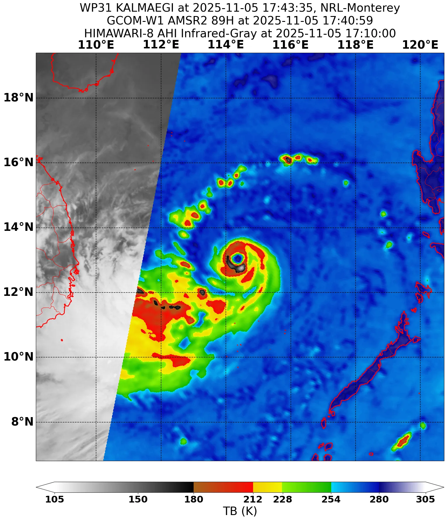
AAXX 06121 48870 01497 80702 10238 20226 39673 49680 57239 60854 76062 81024 333 10252 59391 60852 91132 91502 96160 555 20238

Station: QUY NHON (4 m - 13.767N - 109.217E)

Synop, reported by a manned station.

Day: 06/11/2025
Hour: 12 UTC

Air Temperature : +23.8ºC
Dew point: +22.6ºC
Air relative humidity: 93%

Maximun temperature: +25.2ºC
Station pressure: 967.3 Hpa
Sea level pressure: 968.0 Hpa
Pressure change: 23.9 Hpa, Decreasing steadily; resultant pressure lower
Surface pressure change in the last 24 hours: -39.1 Hpa

Wind direction: 65º-74º (east).
Wind speed: 2 m/s (7.2 Km/h), from anemometer.

Horizontal visibility: 10 kilometers.

Total cloud cover: 8 eighths
Height above ground of cloud base of lowest cloud seen : 300 to 600 m
Low clouds: no low clouds.
Middle clouds: altostratus opacus or nimbostratus. (Cover: 1 eighths).
High clouds: cirrus unicus or fibratus (progressively invading sky).

Present weather: intermittent light rain.
Past weather: rain, cloud covering more than half of sky during whole period.

Precipitation: 85.0 mm in the last 24 hours.
Precipitation: 85.0 mm in the last 12 hours.


SUPPLEMENTARY INFORMATION

Wind gust: 32 m/s (115.2 Km/h), from anemometer.
wind direction: 15º-24º (component north).
Present weather: rain, falling speed less than 1,0 mm/h.


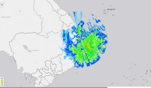
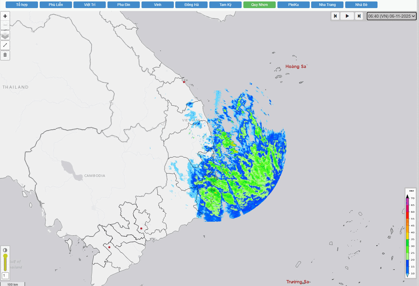
I was able to make a radar animation of the Quy Nhon radar up until 17:10 VST when is stopped transmitting data. I hope it's just power outage and the typhoon didn't damage the radome.
Image
1 likes   
The posts in this forum are NOT official forecast and should not be used as such. They are just the opinion of the poster and may or may not be backed by sound meteorological data. They are NOT endorsed by any professional institution or storm2k.org. For official information, please refer to RSMC, NHC and NWS products.

User avatar
cycloneye
Admin
Admin
Posts: 148418
Age: 69
Joined: Thu Oct 10, 2002 10:54 am
Location: San Juan, Puerto Rico

Re: WPAC: KALMAEGI - Typhoon - Discussion

#118 Postby cycloneye » Thu Nov 06, 2025 10:06 am

The final warning from JTWC.

Image
0 likes   
Visit the Caribbean-Central America Weather Thread where you can find at first post web cams,radars
and observations from Caribbean basin members Click Here

User avatar
cycloneye
Admin
Admin
Posts: 148418
Age: 69
Joined: Thu Oct 10, 2002 10:54 am
Location: San Juan, Puerto Rico

Re: WPAC: KALMAEGI - Post-Tropical - Discussion

#119 Postby cycloneye » Thu Nov 06, 2025 12:42 pm

Sad news as the fatalities have increased to 181.

Image
2 likes   
Visit the Caribbean-Central America Weather Thread where you can find at first post web cams,radars
and observations from Caribbean basin members Click Here


Return to “Active Storms - WestPAC/Asia”

Who is online

Users browsing this forum: No registered users and 16 guests