
WPAC: RAGASA - Typhoon
Moderators: S2k Moderators, WesternPacificWeatherMods
Forum rules

The posts in this forum are NOT official forecast and should not be used as such. They are just the opinion of the poster and may or may not be backed by sound meteorological data. They are NOT endorsed by any professional institution or STORM2K.
-
Hurricane2022

- Category 5

- Posts: 1694
- Joined: Tue Aug 23, 2022 11:38 pm
- Location: Araçatuba, Brazil
Re: WPAC: RAGASA - Typhoon
Ragasa is doing a very Haiyan-esque EWRC.
0 likes
Sorry for the bad English sometimes...!
For reliable and detailed information for any meteorological phenomenon, please consult the National Hurricane Center, Joint Typhoon Warning Center , or your local Meteo Center.
--------
Una cvm Christo, pro Christo, et in Christo. Sit nomen Domini benedictvm.
For reliable and detailed information for any meteorological phenomenon, please consult the National Hurricane Center, Joint Typhoon Warning Center , or your local Meteo Center.
--------
Una cvm Christo, pro Christo, et in Christo. Sit nomen Domini benedictvm.
-
StormWeather

- Category 1

- Posts: 400
- Joined: Wed Jun 05, 2024 2:34 pm
Re: WPAC: RAGASA - Typhoon
Hurricane2022 wrote:Ragasa is doing a very Haiyan-esque EWRC.
https://i.imgur.com/Aqxzdah.gif
Is that good or bad…
0 likes
Just an average cyclone tracker
The posts in this forum are NOT official forecasts and should not be used as such. They are just the opinion of the poster and may or may not be backed by sound meteorological data. They are NOT endorsed by any professional institution or storm2k.org. For official information, please refer to the NHC and NWS products
The posts in this forum are NOT official forecasts and should not be used as such. They are just the opinion of the poster and may or may not be backed by sound meteorological data. They are NOT endorsed by any professional institution or storm2k.org. For official information, please refer to the NHC and NWS products
-
Hurricane2022
- Category 5
- Posts: 1694
- Joined: Tue Aug 23, 2022 11:38 pm
- Location: Araçatuba, Brazil
Re: WPAC: RAGASA - Typhoon
StormWeather wrote:Hurricane2022 wrote:Ragasa is doing a very Haiyan-esque EWRC.
https://i.imgur.com/Aqxzdah.gif
Is that good or bad…
For Ragasa, this is perfect.
For Batanes, it's a terrible news
1 likes
Sorry for the bad English sometimes...!
For reliable and detailed information for any meteorological phenomenon, please consult the National Hurricane Center, Joint Typhoon Warning Center , or your local Meteo Center.
--------
Una cvm Christo, pro Christo, et in Christo. Sit nomen Domini benedictvm.
For reliable and detailed information for any meteorological phenomenon, please consult the National Hurricane Center, Joint Typhoon Warning Center , or your local Meteo Center.
--------
Una cvm Christo, pro Christo, et in Christo. Sit nomen Domini benedictvm.
-
StormWeather
- Category 1
- Posts: 400
- Joined: Wed Jun 05, 2024 2:34 pm
Re: WPAC: RAGASA - Typhoon
Hurricane2022 wrote:StormWeather wrote:Hurricane2022 wrote:Ragasa is doing a very Haiyan-esque EWRC.
https://i.imgur.com/Aqxzdah.gif
Is that good or bad…
For Ragasa, this is perfect.
For Batanes, it's a terrible news
So mixed. I’ll take a weaker storm any day, it’s the enlarged wind field that I don’t want
0 likes
Just an average cyclone tracker
The posts in this forum are NOT official forecasts and should not be used as such. They are just the opinion of the poster and may or may not be backed by sound meteorological data. They are NOT endorsed by any professional institution or storm2k.org. For official information, please refer to the NHC and NWS products
The posts in this forum are NOT official forecasts and should not be used as such. They are just the opinion of the poster and may or may not be backed by sound meteorological data. They are NOT endorsed by any professional institution or storm2k.org. For official information, please refer to the NHC and NWS products

Re: WPAC: RAGASA - Typhoon
It looks like an incredibly efficient EWRC on MIMIC, the inner eyewall basically loses no intensity while the outer eyewall very quickly develops, then the inner eyewall dies off almost immediately:

2 likes
Re: WPAC: RAGASA - Typhoon
12z HAFS-A brings the right front quadrant of Ragasa directly into Hong Kong as a 135kt storm after passing over the Babuyan islands at 150kts. This would pretty much be a worst case scenario 

 |  |
1 likes
-
Ed_2001

- Tropical Storm

- Posts: 241
- Age: 23
- Joined: Wed Jun 21, 2017 11:39 pm
- Location: Santa Barbara, CA>>Tampa, FL
Re: WPAC: RAGASA - Typhoon
For Southern China, this storm is going to be Mangkhut but it missed the Luzon.
On a serious note, this is likely going to be an historic storm.
On a serious note, this is likely going to be an historic storm.
4 likes
The answer my friend, is blowing in the wind...
-
CrazyC83
- Professional-Met

- Posts: 34106
- Joined: Tue Mar 07, 2006 11:57 pm
- Location: Deep South, for the first time!
Re: WPAC: RAGASA - Typhoon
I'd consider that buoy legitimate personally and set the intensity at 155 kt, largely based on the buoy pressure with a perfectly calm peak. What would be the KZC for 900 mb in this situation?
3 likes

Re: WPAC: RAGASA - Typhoon
Ed_2001 wrote:For Southern China, this storm is going to be Mangkhut but it missed the Luzon.
On a serious note, this is likely going to be an historic storm.
Yep, the first model runs of this storm (especially Euro AI) striking Hong Kong without hitting Luzon made me think this would be the version of Mangkhut if it didn't make landfall over Luzon.
1 likes
ヤンデレ女が寝取られるているのを見たい!!!
ECMWF ensemble NWPAC plots: https://ecmwfensnwpac.imgbb.com/
Multimodel NWPAC plots: https://multimodelnwpac.imgbb.com/
GFS Ensemble NWPAC plots (16 & 35 day forecast): https://gefsnwpac.imgbb.com/
Plots updated automatically
ECMWF ensemble NWPAC plots: https://ecmwfensnwpac.imgbb.com/
Multimodel NWPAC plots: https://multimodelnwpac.imgbb.com/
GFS Ensemble NWPAC plots (16 & 35 day forecast): https://gefsnwpac.imgbb.com/
Plots updated automatically
-
WaveBreaking

- Category 2

- Posts: 615
- Joined: Sun Jun 30, 2024 11:33 am
- Location: US
Re: WPAC: RAGASA - Typhoon


3 likes
I am NOT a professional meteorologist, so take all of my posts with a grain of salt. My opinions are mine and mine alone.
-
StormWeather
- Category 1
- Posts: 400
- Joined: Wed Jun 05, 2024 2:34 pm
Re: WPAC: RAGASA - Typhoon
WaveBreaking wrote::double:
https://i.imgur.com/2qQSEgE.jpeg
I smell an even stronger beast incoming…
3 likes
Just an average cyclone tracker
The posts in this forum are NOT official forecasts and should not be used as such. They are just the opinion of the poster and may or may not be backed by sound meteorological data. They are NOT endorsed by any professional institution or storm2k.org. For official information, please refer to the NHC and NWS products
The posts in this forum are NOT official forecasts and should not be used as such. They are just the opinion of the poster and may or may not be backed by sound meteorological data. They are NOT endorsed by any professional institution or storm2k.org. For official information, please refer to the NHC and NWS products
-
Kingarabian

- S2K Supporter

- Posts: 16217
- Joined: Sat Aug 08, 2009 3:06 am
- Location: Honolulu, Hawaii
-
WaveBreaking
- Category 2
- Posts: 615
- Joined: Sun Jun 30, 2024 11:33 am
- Location: US
Re: WPAC: RAGASA - Typhoon
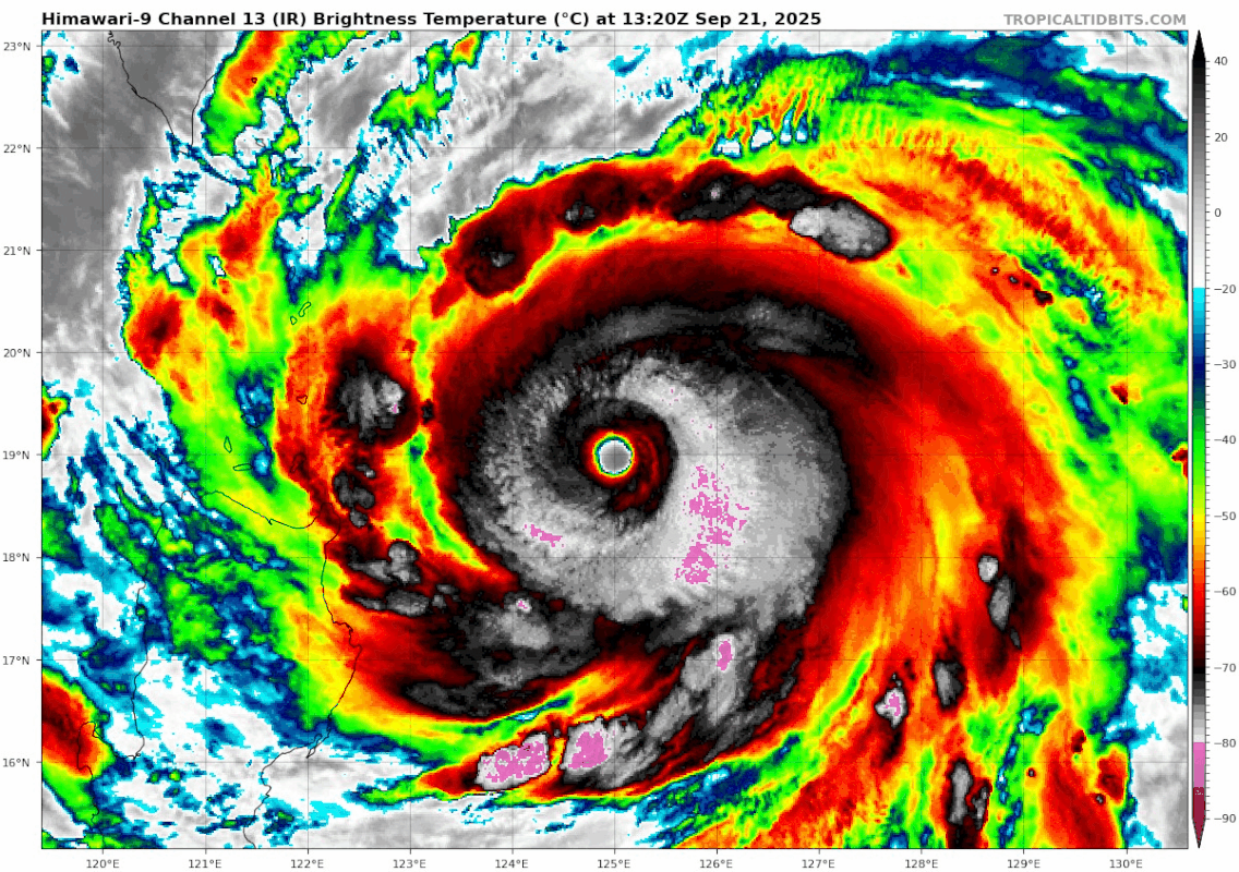
It is trying its absolute hardest to look like Haiyan rn. It even has a band of deep convection in front of the core.
2 likes
I am NOT a professional meteorologist, so take all of my posts with a grain of salt. My opinions are mine and mine alone.

-
Sciencerocks
- Category 5
- Posts: 9457
- Age: 39
- Joined: Thu Jul 06, 2017 1:51 am

-
Kingarabian
- S2K Supporter
- Posts: 16217
- Joined: Sat Aug 08, 2009 3:06 am
- Location: Honolulu, Hawaii
Re: WPAC: RAGASA - Typhoon
7.5 thanks to banding feature
TPPN12 PGTW 212117
A. SUPER TYPHOON 24W (RAGASA)
B. 21/2030Z
C. 19.17N
D. 123.72E
E. ONE/GK2A
F. T7.5/7.5/D1.5/24HRS STT: D0.5/03HRS
G. IR/EIR
H. REMARKS: 01A/PBO EYE/ANMTN. WMG EYE SURROUNDED BY W YIELDS AN
E# OF 6.0. ADDED 1.0 EYE ADJUSTMENT FOR W, AND ADDED 0.5 FOR BF,
TO YIELD A DT OF 7.5. MET AND PT AGREES. DBO DT.
I. ADDITIONAL POSITIONS: NONE
TIMMERMAN
1 likes
ヤンデレ女が寝取られるているのを見たい!!!
ECMWF ensemble NWPAC plots: https://ecmwfensnwpac.imgbb.com/
Multimodel NWPAC plots: https://multimodelnwpac.imgbb.com/
GFS Ensemble NWPAC plots (16 & 35 day forecast): https://gefsnwpac.imgbb.com/
Plots updated automatically
ECMWF ensemble NWPAC plots: https://ecmwfensnwpac.imgbb.com/
Multimodel NWPAC plots: https://multimodelnwpac.imgbb.com/
GFS Ensemble NWPAC plots (16 & 35 day forecast): https://gefsnwpac.imgbb.com/
Plots updated automatically


Re: WPAC: RAGASA - Typhoon
It is extremely powerful typhoons like this one that always make me wish that JMA is not so conservative when it comes to pressure.
Especially when there are data on the ground.
Especially when there are data on the ground.
2 likes
Return to “Active Storms - WestPAC/Asia”
Who is online
Users browsing this forum: aspen and 49 guests