WPAC: FUNG-WONG - Post-Tropical - Discussion
Moderator: S2k Moderators
-
dexterlabio
- Category 5

- Posts: 3499
- Joined: Sat Oct 24, 2009 11:50 pm
Re: WPAC: FUNG-WONG - Typhoon - Discussion
If Fung-wong maintains current trajectory and intensity (about the same as Vamco in 2020) then I expect the same wind and rainfall impact as what was experienced in Metro Manila during that storm. Although I expect Fung-wong will be a much stronger typhoon.
1 likes
Personal Forecast Disclaimer:
The posts in this forum are NOT official forecast and should not be used as such. They are just the opinion of the poster and may or may not be backed by sound meteorological data. They are NOT endorsed by any professional institution or storm2k.org. For official information, please refer to the NHC and NWS products.
The posts in this forum are NOT official forecast and should not be used as such. They are just the opinion of the poster and may or may not be backed by sound meteorological data. They are NOT endorsed by any professional institution or storm2k.org. For official information, please refer to the NHC and NWS products.

Re: WPAC: FUNG-WONG - Typhoon - Discussion
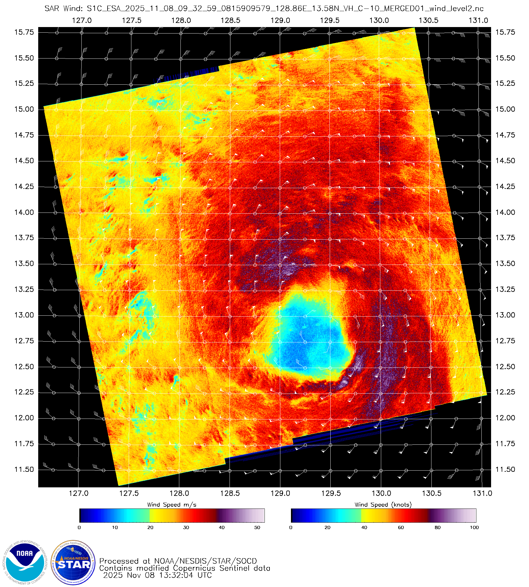
mrbagyo wrote:Latest SAR pass (no wind info plot though)
https://s12.gifyu.com/images/b3GAj.png
It seems to be about 53 m/s = 103 knots based on the info txt
0 likes
ヤンデレ女が寝取られるているのを見たい!!!
ECMWF ensemble NWPAC plots: https://ecmwfensnwpac.imgbb.com/
Multimodel NWPAC plots: https://multimodelnwpac.imgbb.com/
GFS Ensemble NWPAC plots (16 & 35 day forecast): https://gefsnwpac.imgbb.com/
Plots updated automatically
ECMWF ensemble NWPAC plots: https://ecmwfensnwpac.imgbb.com/
Multimodel NWPAC plots: https://multimodelnwpac.imgbb.com/
GFS Ensemble NWPAC plots (16 & 35 day forecast): https://gefsnwpac.imgbb.com/
Plots updated automatically
-
cycloneye

- Admin

- Posts: 149220
- Age: 69
- Joined: Thu Oct 10, 2002 10:54 am
- Location: San Juan, Puerto Rico
Re: WPAC: FUNG-WONG - Typhoon - Discussion
Track moved more south at 15z. Moving west at 275.

0 likes
Visit the Caribbean-Central America Weather Thread where you can find at first post web cams,radars
and observations from Caribbean basin members Click Here
and observations from Caribbean basin members Click Here
-
mrbagyo

- Category 5
- Posts: 3963
- Age: 33
- Joined: Thu Apr 12, 2012 9:18 am
- Location: 14.13N 120.98E
- Contact:
Re: WPAC: FUNG-WONG - Typhoon - Discussion
Hayabusa wrote:mrbagyo wrote:Latest SAR pass (no wind info plot though)
https://s12.gifyu.com/images/b3GAj.png
It seems to be about 53 m/s = 103 knots based on the info txt
idk if it's mps, SAR max wind speed on the info txt from the previous pass was even higher at 100
0 likes
The posts in this forum are NOT official forecast and should not be used as such. They are just the opinion of the poster and may or may not be backed by sound meteorological data. They are NOT endorsed by any professional institution or storm2k.org. For official information, please refer to RSMC, NHC and NWS products.
Re: WPAC: FUNG-WONG - Typhoon - Discussion
Latest ADT raw but could be overestimating, not considering a large eye...
2025NOV08 140000 6.4 930.9 124.6 6.4 7.2 7.5 1.7T/6hr OFF OFF OFF OFF -5.92 -83.03 EYE 24 IR 21.1 13.50 -127.57 FCST HIM-8 21.9
0 likes
ヤンデレ女が寝取られるているのを見たい!!!
ECMWF ensemble NWPAC plots: https://ecmwfensnwpac.imgbb.com/
Multimodel NWPAC plots: https://multimodelnwpac.imgbb.com/
GFS Ensemble NWPAC plots (16 & 35 day forecast): https://gefsnwpac.imgbb.com/
Plots updated automatically
ECMWF ensemble NWPAC plots: https://ecmwfensnwpac.imgbb.com/
Multimodel NWPAC plots: https://multimodelnwpac.imgbb.com/
GFS Ensemble NWPAC plots (16 & 35 day forecast): https://gefsnwpac.imgbb.com/
Plots updated automatically
Re: WPAC: FUNG-WONG - Typhoon - Discussion
mrbagyo wrote:Hayabusa wrote:mrbagyo wrote:Latest SAR pass (no wind info plot though)
https://s12.gifyu.com/images/b3GAj.png
It seems to be about 53 m/s = 103 knots based on the info txt
idk if it's mps, SAR max wind speed on the info txt from the previous pass was even higher at 100
I just opened the .nc file itself it says the units is in m/s and indeed the max wind is 53.218 m/s or 103 knots
1 likes
ヤンデレ女が寝取られるているのを見たい!!!
ECMWF ensemble NWPAC plots: https://ecmwfensnwpac.imgbb.com/
Multimodel NWPAC plots: https://multimodelnwpac.imgbb.com/
GFS Ensemble NWPAC plots (16 & 35 day forecast): https://gefsnwpac.imgbb.com/
Plots updated automatically
ECMWF ensemble NWPAC plots: https://ecmwfensnwpac.imgbb.com/
Multimodel NWPAC plots: https://multimodelnwpac.imgbb.com/
GFS Ensemble NWPAC plots (16 & 35 day forecast): https://gefsnwpac.imgbb.com/
Plots updated automatically
-
xtyphooncyclonex

- Category 5
- Posts: 3890
- Age: 24
- Joined: Sat Dec 08, 2012 9:07 am
- Location: Cebu City
- Contact:
Re: WPAC: FUNG-WONG - Typhoon - Discussion
Increasingly worried about the impacts and disruptions here at the Metro. Looks like it could pack a punch.
0 likes
REMINDER: My opinions that I, or any other NON Pro-Met in this forum, are unofficial. Please do not take my opinions as an official forecast and warning. I am NOT a meteorologist. Following my forecasts blindly may lead to false alarm, danger and risk if official forecasts from agencies are ignored.
-
mrbagyo
- Category 5
- Posts: 3963
- Age: 33
- Joined: Thu Apr 12, 2012 9:18 am
- Location: 14.13N 120.98E
- Contact:
Re: WPAC: FUNG-WONG - Typhoon - Discussion
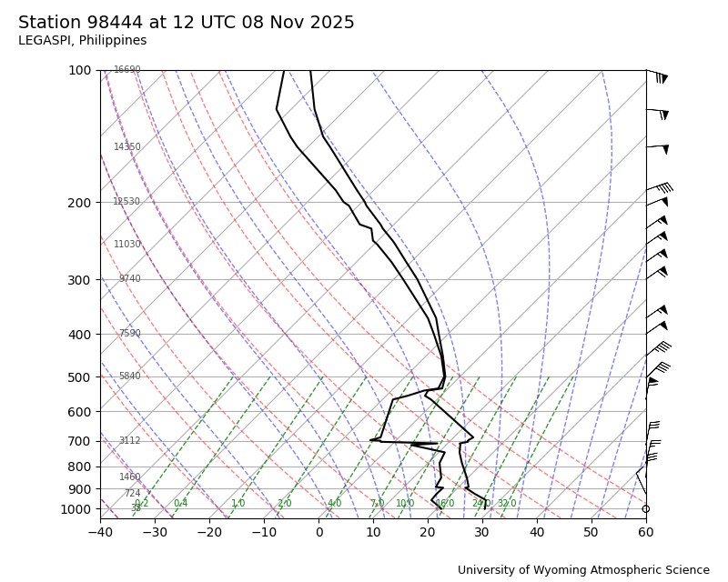
There still seems to be some mid-level dry air present ahead of the storm, as indicated by the latest Legaspi sounding. This could explain why convection in the northwestern quadrant hasn’t developed as strongly as it has in the southern quadrants.
0 likes
The posts in this forum are NOT official forecast and should not be used as such. They are just the opinion of the poster and may or may not be backed by sound meteorological data. They are NOT endorsed by any professional institution or storm2k.org. For official information, please refer to RSMC, NHC and NWS products.
Re: WPAC: FUNG-WONG - Typhoon - Discussion
CI and Raw increasing
2025NOV08 123000 6.1 937.7 117.4 6.1 6.5 7.0 2.7T/12hr OFF OFF OFF OFF -28.73 -82.29 EYE -99 IR 21.1 13.22 -128.44 ARCHER HIM-8 21.0
2025NOV08 130000 6.2 935.5 119.8 6.2 6.5 7.0 2.7T/12hr OFF OFF OFF OFF -37.63 -83.85 EYE -99 IR 21.1 13.26 -128.30 ARCHER HIM-8 21.2
2025NOV08 133000 6.2 935.5 119.8 6.2 6.5 6.8 2.7T/12hr OFF OFF OFF OFF -36.07 -81.26 EYE -99 IR 21.1 13.09 -127.44 ARCHER HIM-8 21.7
2025NOV08 140000 6.4 930.9 124.6 6.4 7.2 7.5 1.7T/6hr OFF OFF OFF OFF -5.92 -83.03 EYE 24 IR 21.1 13.50 -127.57 FCST HIM-8 21.9
2025NOV08 142000 6.4 930.8 124.6 6.4 7.2 7.5 1.7T/6hr OFF OFF OFF OFF -8.35 -83.38 EYE 21 IR 21.1 13.55 -127.69 ARCHER HIM-8 21.9
2025NOV08 150000 6.8 920.7 134.8 6.8 7.3 7.6 1.7T/6hr OFF OFF OFF OFF 0.97 -83.63 EYE 24 IR 21.1 13.60 -127.30 FCST HIM-8 22.2
0 likes
ヤンデレ女が寝取られるているのを見たい!!!
ECMWF ensemble NWPAC plots: https://ecmwfensnwpac.imgbb.com/
Multimodel NWPAC plots: https://multimodelnwpac.imgbb.com/
GFS Ensemble NWPAC plots (16 & 35 day forecast): https://gefsnwpac.imgbb.com/
Plots updated automatically
ECMWF ensemble NWPAC plots: https://ecmwfensnwpac.imgbb.com/
Multimodel NWPAC plots: https://multimodelnwpac.imgbb.com/
GFS Ensemble NWPAC plots (16 & 35 day forecast): https://gefsnwpac.imgbb.com/
Plots updated automatically
Re: WPAC: FUNG-WONG - Typhoon - Discussion
Moved pretty fast for the past 3 hours on 15z JMA update
T2526(Fung-wong)
Issued at 2025/11/08 15:45 UTC
Analysis at 11/08 15 UTC
Grade TY
Scale Large
Intensity -
Center position N13°30′ (13.5°)
E127°30′ (127.5°)
Direction and speed of movement W 40 km/h (22 kt)
Central pressure 955 hPa
Maximum sustained wind speed near center 40 m/s (80 kt)
Maximum wind gust speed 60 m/s (115 kt)
Radius of 50-kt wind area 220 km (120 NM)
Radius of 30-kt wind area NE850 km (450 NM)
SW500 km (270 NM)
1 likes
ヤンデレ女が寝取られるているのを見たい!!!
ECMWF ensemble NWPAC plots: https://ecmwfensnwpac.imgbb.com/
Multimodel NWPAC plots: https://multimodelnwpac.imgbb.com/
GFS Ensemble NWPAC plots (16 & 35 day forecast): https://gefsnwpac.imgbb.com/
Plots updated automatically
ECMWF ensemble NWPAC plots: https://ecmwfensnwpac.imgbb.com/
Multimodel NWPAC plots: https://multimodelnwpac.imgbb.com/
GFS Ensemble NWPAC plots (16 & 35 day forecast): https://gefsnwpac.imgbb.com/
Plots updated automatically
-
cycloneye
- Admin
- Posts: 149220
- Age: 69
- Joined: Thu Oct 10, 2002 10:54 am
- Location: San Juan, Puerto Rico
Re: WPAC: FUNG-WONG - Typhoon - Discussion
0 likes
Visit the Caribbean-Central America Weather Thread where you can find at first post web cams,radars
and observations from Caribbean basin members Click Here
and observations from Caribbean basin members Click Here

Re: WPAC: FUNG-WONG - Typhoon - Discussion
Impressive cloud tops (as always), but some shear is still affecting it.

1 likes
TC naming lists: retirements and intensity
Most aggressive Advisory #1's in North Atlantic (cr. kevin for starting the list)
Most aggressive Advisory #1's in North Atlantic (cr. kevin for starting the list)
-
cycloneye
- Admin
- Posts: 149220
- Age: 69
- Joined: Thu Oct 10, 2002 10:54 am
- Location: San Juan, Puerto Rico
Re: WPAC: FUNG-WONG - Typhoon - Discussion
0 likes
Visit the Caribbean-Central America Weather Thread where you can find at first post web cams,radars
and observations from Caribbean basin members Click Here
and observations from Caribbean basin members Click Here
Re: WPAC: FUNG-WONG - Typhoon - Discussion
JMA upped the intensity
T2526(Fung-wong)
Issued at 2025/11/08 18:45 UTC
Analysis at 11/08 18 UTC
Grade TY
Scale Large
Intensity Very Strong
Center position N13°50′ (13.8°)
E126°25′ (126.4°)
Direction and speed of movement WNW 35 km/h (20 kt)
Central pressure 950 hPa
Maximum sustained wind speed near center 45 m/s (85 kt)
Maximum wind gust speed 60 m/s (120 kt)
Radius of 50-kt wind area SE260 km (140 NM)
NW220 km (120 NM)
Radius of 30-kt wind area N650 km (350 NM)
S500 km (270 NM)
0 likes
ヤンデレ女が寝取られるているのを見たい!!!
ECMWF ensemble NWPAC plots: https://ecmwfensnwpac.imgbb.com/
Multimodel NWPAC plots: https://multimodelnwpac.imgbb.com/
GFS Ensemble NWPAC plots (16 & 35 day forecast): https://gefsnwpac.imgbb.com/
Plots updated automatically
ECMWF ensemble NWPAC plots: https://ecmwfensnwpac.imgbb.com/
Multimodel NWPAC plots: https://multimodelnwpac.imgbb.com/
GFS Ensemble NWPAC plots (16 & 35 day forecast): https://gefsnwpac.imgbb.com/
Plots updated automatically
Re: WPAC: FUNG-WONG - Typhoon - Discussion
18z/2am local update, signal #3 raised over the capital region, last time it was STS Nalgae of 2022
0 likes
ヤンデレ女が寝取られるているのを見たい!!!
ECMWF ensemble NWPAC plots: https://ecmwfensnwpac.imgbb.com/
Multimodel NWPAC plots: https://multimodelnwpac.imgbb.com/
GFS Ensemble NWPAC plots (16 & 35 day forecast): https://gefsnwpac.imgbb.com/
Plots updated automatically
ECMWF ensemble NWPAC plots: https://ecmwfensnwpac.imgbb.com/
Multimodel NWPAC plots: https://multimodelnwpac.imgbb.com/
GFS Ensemble NWPAC plots (16 & 35 day forecast): https://gefsnwpac.imgbb.com/
Plots updated automatically
-
cycloneye
- Admin
- Posts: 149220
- Age: 69
- Joined: Thu Oct 10, 2002 10:54 am
- Location: San Juan, Puerto Rico
Re: WPAC: FUNG-WONG - Typhoon - Discussion
32W FUNG-WONG 251108 1800 13.7N 126.6E WPAC 110 949
3 likes
Visit the Caribbean-Central America Weather Thread where you can find at first post web cams,radars
and observations from Caribbean basin members Click Here
and observations from Caribbean basin members Click Here
-
cycloneye
- Admin
- Posts: 149220
- Age: 69
- Joined: Thu Oct 10, 2002 10:54 am
- Location: San Juan, Puerto Rico
Re: WPAC: FUNG-WONG - Typhoon - Discussion
0 likes
Visit the Caribbean-Central America Weather Thread where you can find at first post web cams,radars
and observations from Caribbean basin members Click Here
and observations from Caribbean basin members Click Here
-
mrbagyo
- Category 5
- Posts: 3963
- Age: 33
- Joined: Thu Apr 12, 2012 9:18 am
- Location: 14.13N 120.98E
- Contact:
Re: WPAC: FUNG-WONG - Typhoon - Discussion
this one has more info.
RMW contracted to a still wide 33 nmi from a very wide 54 nmi
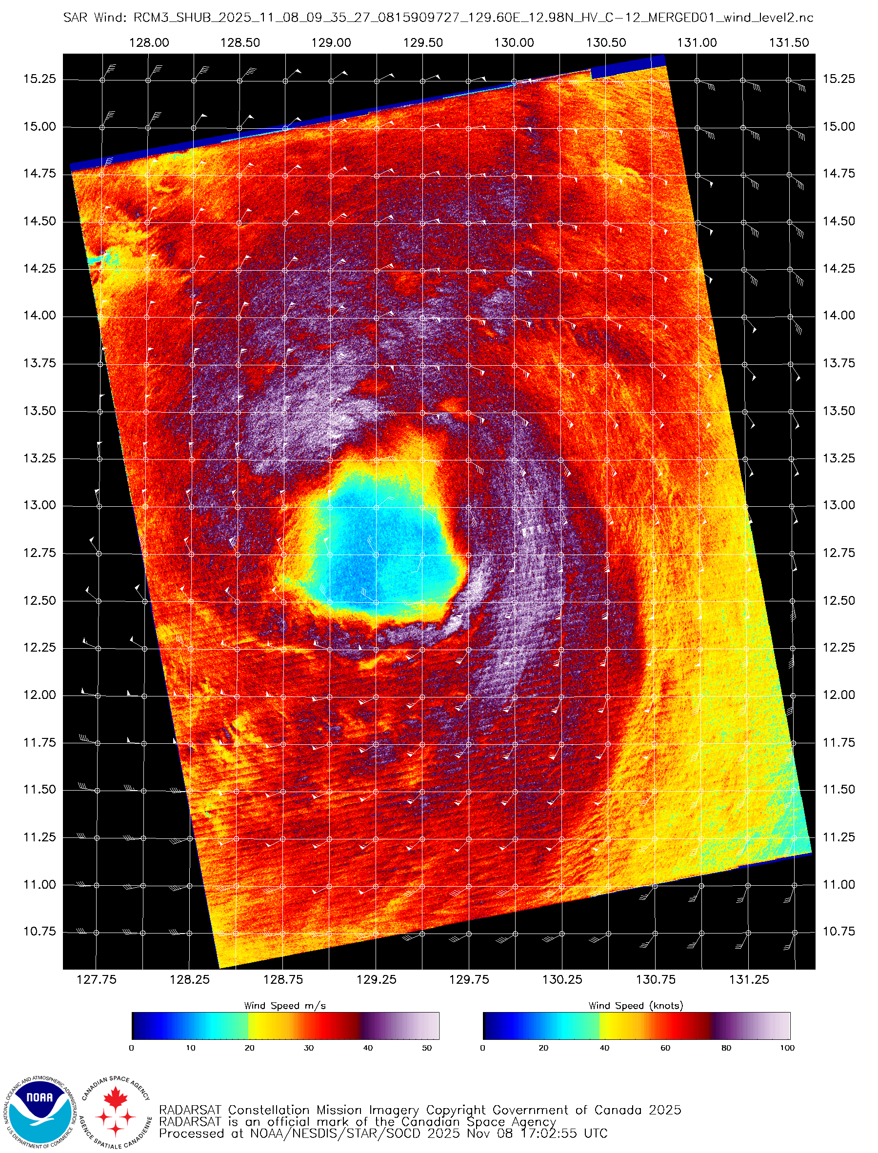
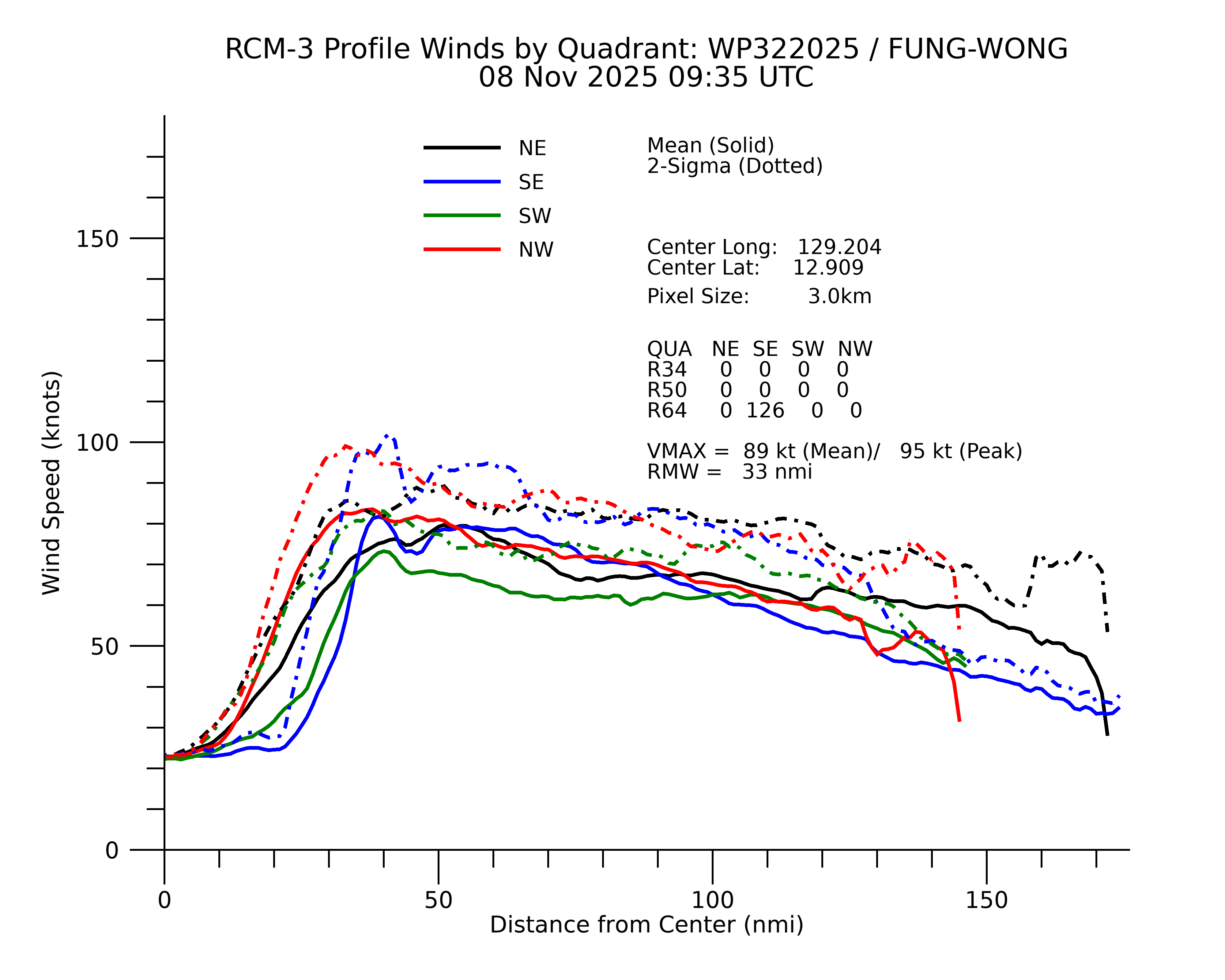
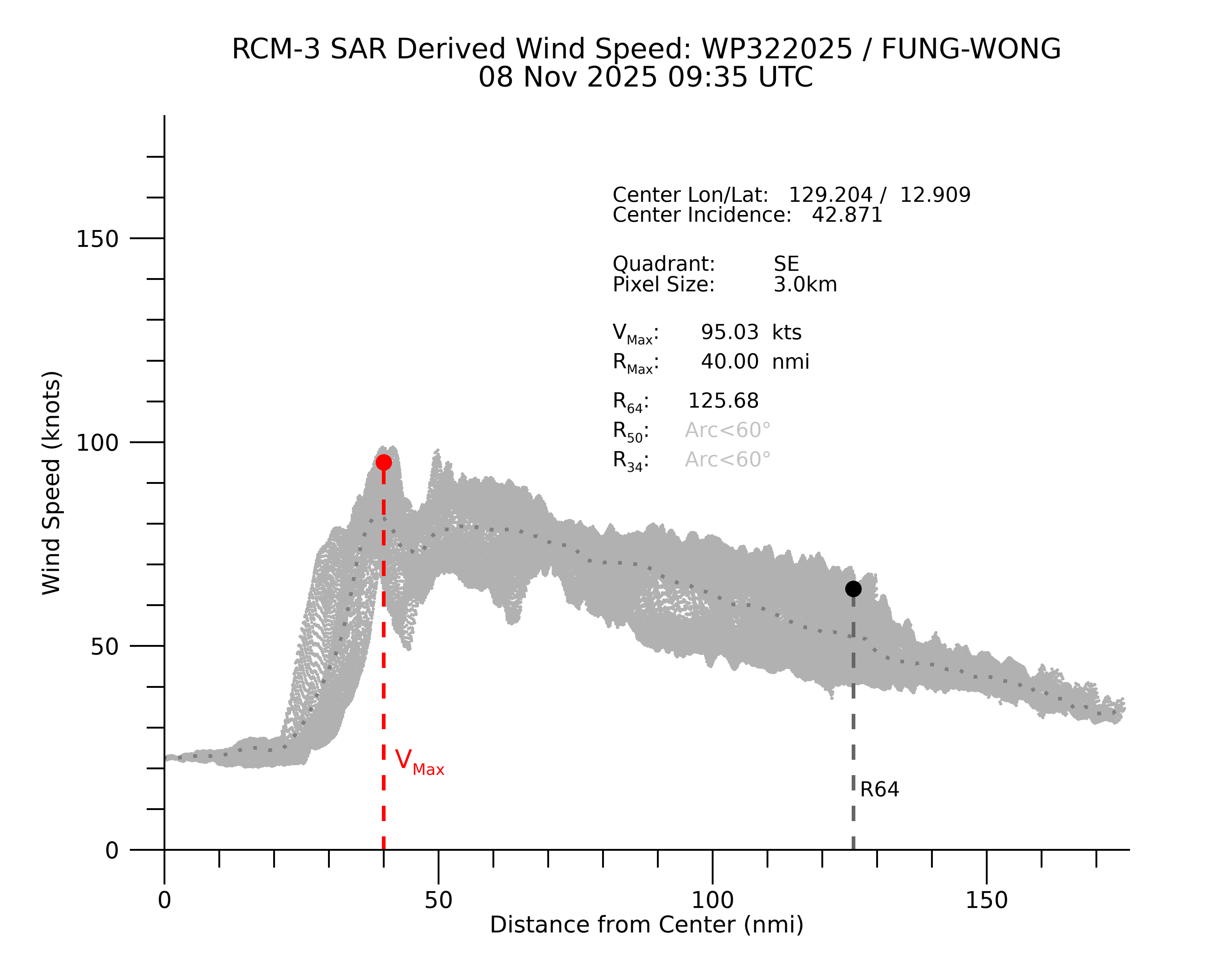
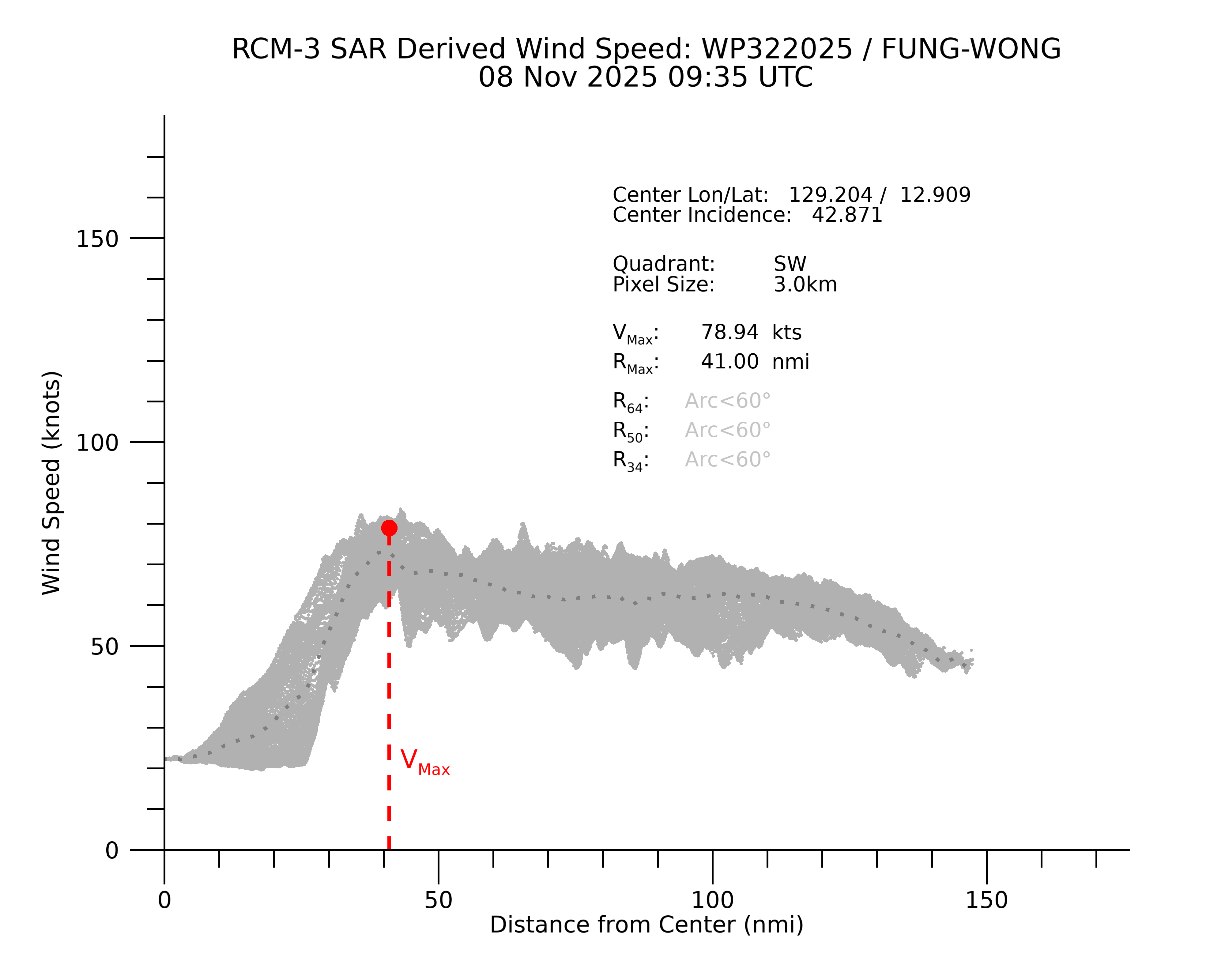
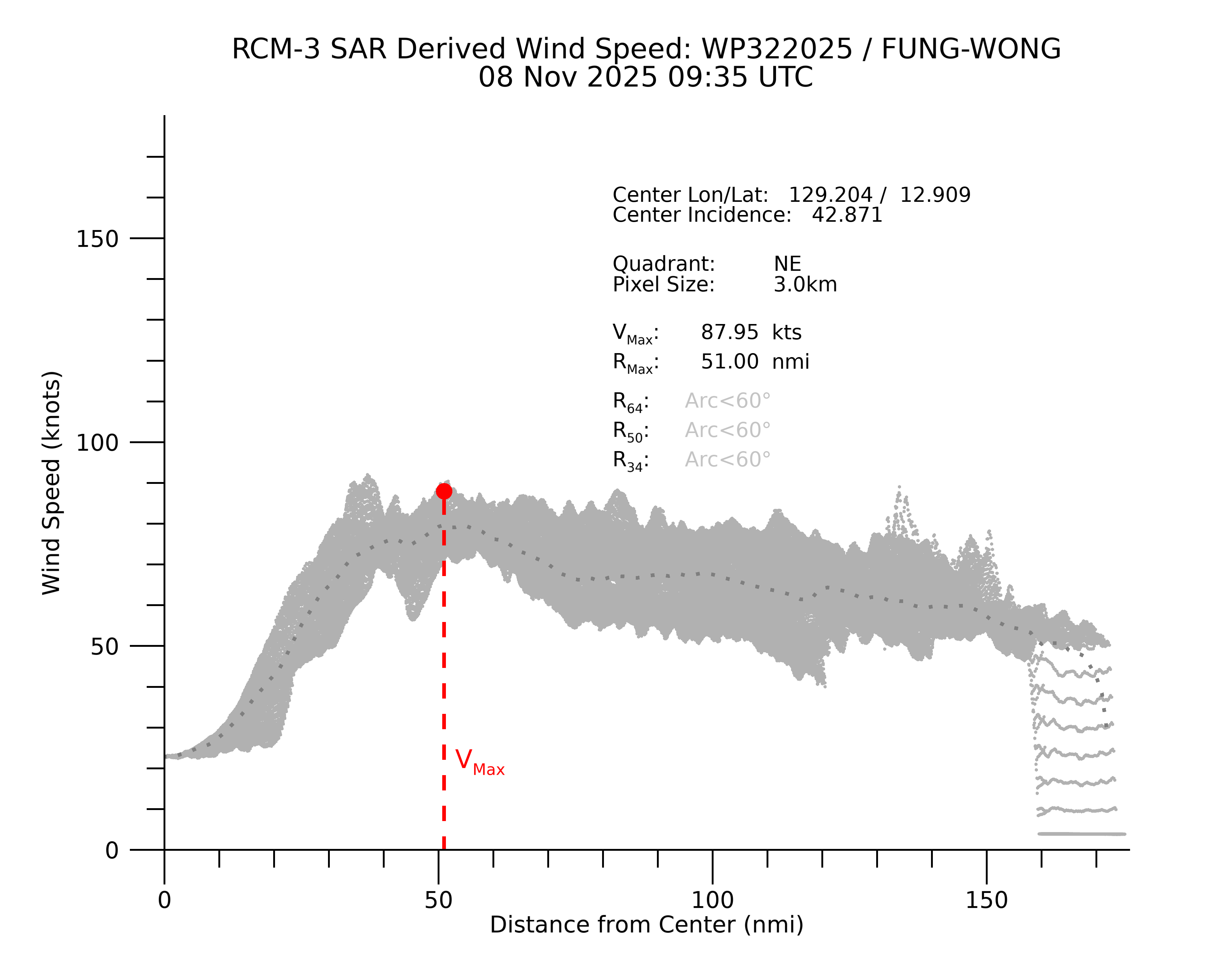

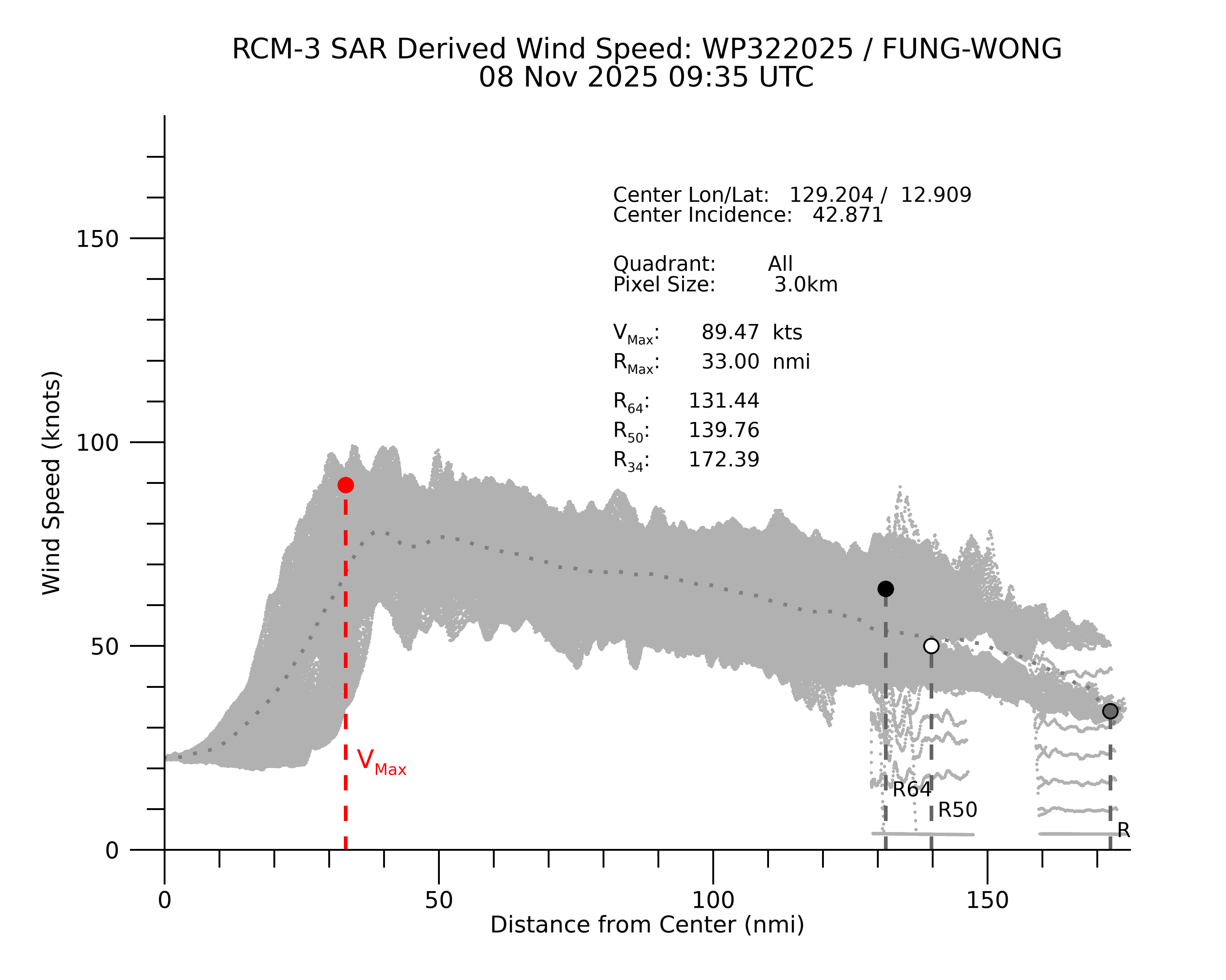
RMW contracted to a still wide 33 nmi from a very wide 54 nmi
2 likes
The posts in this forum are NOT official forecast and should not be used as such. They are just the opinion of the poster and may or may not be backed by sound meteorological data. They are NOT endorsed by any professional institution or storm2k.org. For official information, please refer to RSMC, NHC and NWS products.
-
mrbagyo
- Category 5
- Posts: 3963
- Age: 33
- Joined: Thu Apr 12, 2012 9:18 am
- Location: 14.13N 120.98E
- Contact:
Re: WPAC: FUNG-WONG - Typhoon - Discussion
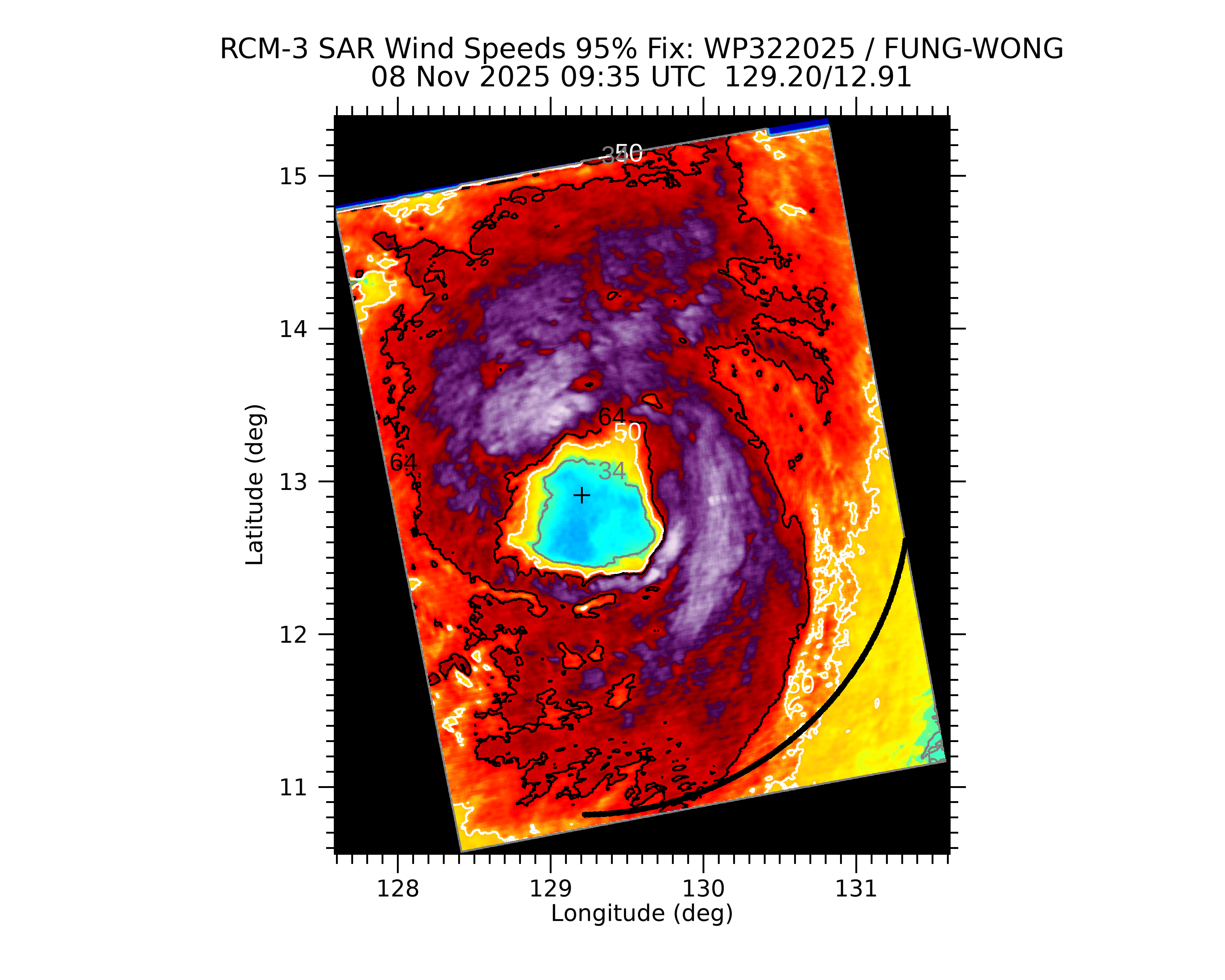
There's mesovortex that can be clearly seen on IR and visible sat imagery.


convection on the northwestern quadrant really failed to take off due to mid level dry air intrusion
convection on the northwestern quadrant really failed to take off due to mid level dry air intrusion
7 likes
The posts in this forum are NOT official forecast and should not be used as such. They are just the opinion of the poster and may or may not be backed by sound meteorological data. They are NOT endorsed by any professional institution or storm2k.org. For official information, please refer to RSMC, NHC and NWS products.
Who is online
Users browsing this forum: No registered users and 6 guests