WPAC: FUNG-WONG - Severe Tropical Storm - Discussion
Moderators: S2k Moderators, WesternPacificWeatherMods
Forum rules

The posts in this forum are NOT official forecast and should not be used as such. They are just the opinion of the poster and may or may not be backed by sound meteorological data. They are NOT endorsed by any professional institution or STORM2K.

Re: WPAC: 90W - Tropical Depression - Discussion
The next name is Fung-wong which means Phoenix, and if it reaches STY it would be the first time the name reaches it.
1 likes
ヤンデレ女が寝取られるているのを見たい!!!
ECMWF ensemble NWPAC plots: https://ecmwfensnwpac.imgbb.com/
Multimodel NWPAC plots: https://multimodelnwpac.imgbb.com/
GFS Ensemble NWPAC plots (16 & 35 day forecast): https://gefsnwpac.imgbb.com/
Plots updated automatically
ECMWF ensemble NWPAC plots: https://ecmwfensnwpac.imgbb.com/
Multimodel NWPAC plots: https://multimodelnwpac.imgbb.com/
GFS Ensemble NWPAC plots (16 & 35 day forecast): https://gefsnwpac.imgbb.com/
Plots updated automatically
Re: WPAC: 90W - Tropical Depression - Discussion
12z UKMET now also being aggressive with the formation of 90W

0 likes
ヤンデレ女が寝取られるているのを見たい!!!
ECMWF ensemble NWPAC plots: https://ecmwfensnwpac.imgbb.com/
Multimodel NWPAC plots: https://multimodelnwpac.imgbb.com/
GFS Ensemble NWPAC plots (16 & 35 day forecast): https://gefsnwpac.imgbb.com/
Plots updated automatically
ECMWF ensemble NWPAC plots: https://ecmwfensnwpac.imgbb.com/
Multimodel NWPAC plots: https://multimodelnwpac.imgbb.com/
GFS Ensemble NWPAC plots (16 & 35 day forecast): https://gefsnwpac.imgbb.com/
Plots updated automatically
Re: WPAC: 90W - Tropical Depression - Discussion
Euro AI 12Z now makes landfall over Northern Luzon
0 likes
ヤンデレ女が寝取られるているのを見たい!!!
ECMWF ensemble NWPAC plots: https://ecmwfensnwpac.imgbb.com/
Multimodel NWPAC plots: https://multimodelnwpac.imgbb.com/
GFS Ensemble NWPAC plots (16 & 35 day forecast): https://gefsnwpac.imgbb.com/
Plots updated automatically
ECMWF ensemble NWPAC plots: https://ecmwfensnwpac.imgbb.com/
Multimodel NWPAC plots: https://multimodelnwpac.imgbb.com/
GFS Ensemble NWPAC plots (16 & 35 day forecast): https://gefsnwpac.imgbb.com/
Plots updated automatically
Re: WPAC: 90W - Tropical Depression - Discussion
First HFSA run, challenging Ragasa and Melissa

3 likes
ヤンデレ女が寝取られるているのを見たい!!!
ECMWF ensemble NWPAC plots: https://ecmwfensnwpac.imgbb.com/
Multimodel NWPAC plots: https://multimodelnwpac.imgbb.com/
GFS Ensemble NWPAC plots (16 & 35 day forecast): https://gefsnwpac.imgbb.com/
Plots updated automatically
ECMWF ensemble NWPAC plots: https://ecmwfensnwpac.imgbb.com/
Multimodel NWPAC plots: https://multimodelnwpac.imgbb.com/
GFS Ensemble NWPAC plots (16 & 35 day forecast): https://gefsnwpac.imgbb.com/
Plots updated automatically
-
cycloneye

- Admin

- Posts: 148416
- Age: 69
- Joined: Thu Oct 10, 2002 10:54 am
- Location: San Juan, Puerto Rico
Re: WPAC: 90W - Tropical Depression - Discussion
These are the 12z runs for intensity from global and hurricane models:
Icon=near 917 mbs - UKMET - 990 mbs - GFS near 917 mbs - CMC near 951 mbs - HAFS-A at 890 mbs but it ends at 126 hours. HWRF at 913 mbs but same as HAFS-A ends at 126 hours Euro - Landfall on northern Luzón near 973 mbs.
Icon=near 917 mbs - UKMET - 990 mbs - GFS near 917 mbs - CMC near 951 mbs - HAFS-A at 890 mbs but it ends at 126 hours. HWRF at 913 mbs but same as HAFS-A ends at 126 hours Euro - Landfall on northern Luzón near 973 mbs.
2 likes
Visit the Caribbean-Central America Weather Thread where you can find at first post web cams,radars
and observations from Caribbean basin members Click Here
and observations from Caribbean basin members Click Here
Re: WPAC: 90W - Tropical Depression - Discussion
12z FNV3 looks like a complete landfall scenario this run

1 likes
ヤンデレ女が寝取られるているのを見たい!!!
ECMWF ensemble NWPAC plots: https://ecmwfensnwpac.imgbb.com/
Multimodel NWPAC plots: https://multimodelnwpac.imgbb.com/
GFS Ensemble NWPAC plots (16 & 35 day forecast): https://gefsnwpac.imgbb.com/
Plots updated automatically
ECMWF ensemble NWPAC plots: https://ecmwfensnwpac.imgbb.com/
Multimodel NWPAC plots: https://multimodelnwpac.imgbb.com/
GFS Ensemble NWPAC plots (16 & 35 day forecast): https://gefsnwpac.imgbb.com/
Plots updated automatically
Re: WPAC: 90W - Tropical Depression - Discussion
TC warning

TD b
Issued at 2025/11/03 19:20 UTC
Analysis at 11/03 18 UTC
Grade TD
Scale -
Intensity -
Center position N8°05′ (8.1°)
E147°50′ (147.8°)
Direction and speed of movement W Slow
Central pressure 1004 hPa
Maximum sustained wind speed near center 15 m/s (30 kt)
Maximum wind gust speed 23 m/s (45 kt)
Forecast for 11/04 18 UTC
Grade TS
Intensity -
Center position of probability circle N9°20′ (9.3°)
E143°55′ (143.9°)
Direction and speed of movement WNW 20 km/h (10 kt)
Central pressure 1000 hPa
Maximum sustained wind speed near center 18 m/s (35 kt)
Maximum wind gust speed 25 m/s (50 kt)
Radius of probability circle 130 km (70 NM)
Forecast for 11/05 18 UTC
Grade TS
Intensity -
Center position of probability circle N10°25′ (10.4°)
E143°00′ (143.0°)
Direction and speed of movement NW Slow
Central pressure 998 hPa
Maximum sustained wind speed near center 20 m/s (40 kt)
Maximum wind gust speed 30 m/s (60 kt)
Radius of probability circle 200 km (110 NM)
Forecast for 11/06 18 UTC
Grade TS
Intensity -
Center position of probability circle N13°05′ (13.1°)
E140°35′ (140.6°)
Direction and speed of movement NW 15 km/h (9 kt)
Central pressure 994 hPa
Maximum sustained wind speed near center 23 m/s (45 kt)
Maximum wind gust speed 35 m/s (65 kt)
Radius of probability circle 260 km (140 NM)
Forecast for 11/07 18 UTC
Grade STS
Intensity -
Center position of probability circle N14°00′ (14.0°)
E137°30′ (137.5°)
Direction and speed of movement WNW 15 km/h (8 kt)
Central pressure 992 hPa
Maximum sustained wind speed near center 25 m/s (50 kt)
Maximum wind gust speed 35 m/s (70 kt)
Radius of probability circle 330 km (180 NM)
Forecast for 11/08 18 UTC
Grade STS
Intensity -
Center position of probability circle N15°35′ (15.6°)
E133°55′ (133.9°)
Direction and speed of movement WNW 20 km/h (10 kt)
Central pressure 990 hPa
Maximum sustained wind speed near center 30 m/s (55 kt)
Maximum wind gust speed 40 m/s (80 kt)
Radius of probability circle 440 km (240 NM)
Radius of storm warning area 480 km (260 NM)
1 likes
ヤンデレ女が寝取られるているのを見たい!!!
ECMWF ensemble NWPAC plots: https://ecmwfensnwpac.imgbb.com/
Multimodel NWPAC plots: https://multimodelnwpac.imgbb.com/
GFS Ensemble NWPAC plots (16 & 35 day forecast): https://gefsnwpac.imgbb.com/
Plots updated automatically
ECMWF ensemble NWPAC plots: https://ecmwfensnwpac.imgbb.com/
Multimodel NWPAC plots: https://multimodelnwpac.imgbb.com/
GFS Ensemble NWPAC plots (16 & 35 day forecast): https://gefsnwpac.imgbb.com/
Plots updated automatically


-
mrbagyo

- Category 5

- Posts: 3922
- Age: 33
- Joined: Thu Apr 12, 2012 9:18 am
- Location: 14.13N 120.98E
- Contact:
Re: WPAC: 90W - Tropical Depression - Discussion

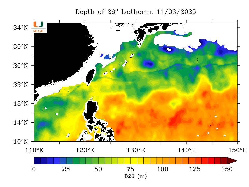
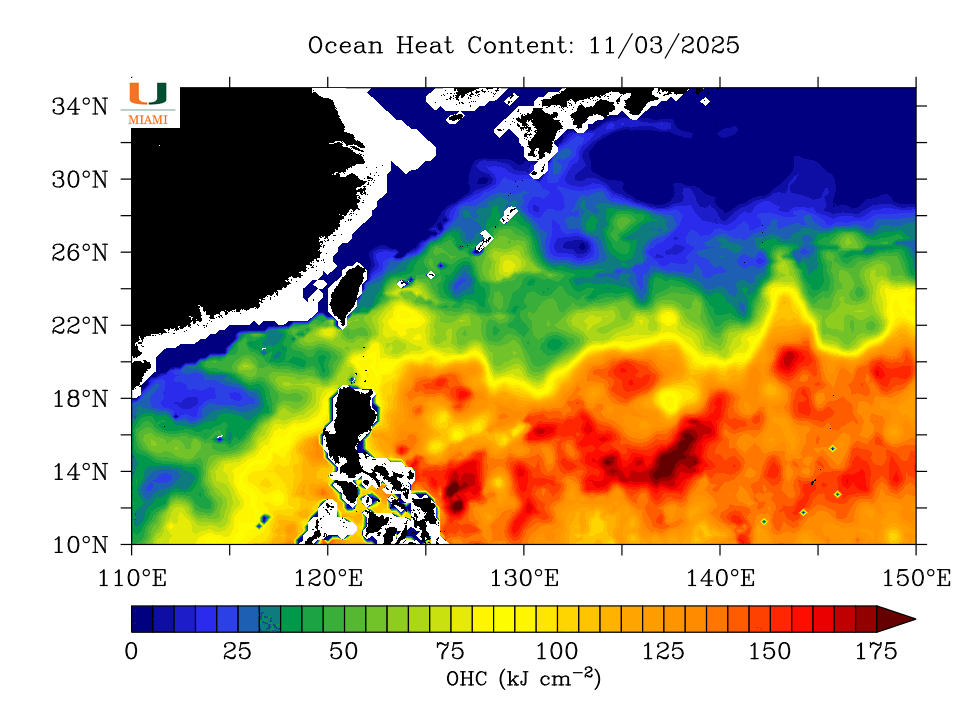
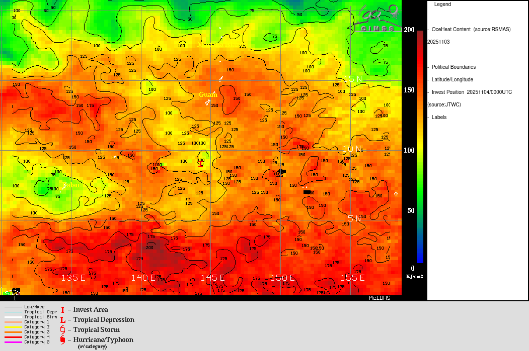
The more south, the more intense it gets, some of the warmest and deepest pocket of warm oceanic water sits just east of Luzon.
0 likes
The posts in this forum are NOT official forecast and should not be used as such. They are just the opinion of the poster and may or may not be backed by sound meteorological data. They are NOT endorsed by any professional institution or storm2k.org. For official information, please refer to RSMC, NHC and NWS products.
-
cycloneye
- Admin
- Posts: 148416
- Age: 69
- Joined: Thu Oct 10, 2002 10:54 am
- Location: San Juan, Puerto Rico
Re: WPAC: 90W - Tropical Depression - Discussion
TCFA Issued

REMARKS: THE AREA OF CONVECTION (INVEST 90W) PREVIOUSLY LOCATED NEAR
9.0N 145.5E IS NOW LOCATED NEAR 9.2N 145.0E, APPROXIMATELY 250 NM SOUTH
OF GUAM. ANIMATED ENHANCED INFRARED SATELLITE IMAGERY AND A 031652Z
AMSR2 89GHZ MICROWAVE IMAGE DEPICTS A CONSOLIDATING LOW-LEVEL
CIRCULATION WITH DISPLACED CELLS OF CONVECTION ALONG THE EASTERN
QUADRANT. A 031127Z ASCAT PASS DEPICTS A BROAD AND ELONGATED CIRCULATION
WITH A SWATH OF 20KT WINDS CURVING ALONG THE EASTERN EDGE OF THE TROUGH.
ENVIRONMENTAL ANALYSIS INDICATES A FAVORABLE ENVIRONMENT FOR DEVELOPMENT
WITH MODERATE EQUATORWARD OUTFLOW, LOW VERTICAL WIND SHEAR (05-10 KTS),
AND WARM SEA SURFACE TEMPERATURES (29-30 C). GLOBAL DETERMINISTIC MODELS
ARE IN AGREEMENT THAT THE AREA WILL STEADILY CONSOLIDATE OVER NEXT 24
HOURS, AS WELL AS TRACK TO THE NORTHWEST. THE EURO MODEL IS SLIGHTLY
DELAYED ON THE DEVELOPMENT TIMELINE WITH CONSOLIDATION TAKING PLACE IN
36 HOURS. MAXIMUM SUSTAINED SURFACE WINDS ARE ESTIMATED AT 18 TO 23
KNOTS. MINIMUM SEA LEVEL PRESSURE IS ESTIMATED TO BE NEAR 1005 MB. THE
POTENTIAL FOR THE DEVELOPMENT OF A SIGNIFICANT TROPICAL CYCLONE
WITHIN THE NEXT 24 HOURS IS HIGH.
0 likes
Visit the Caribbean-Central America Weather Thread where you can find at first post web cams,radars
and observations from Caribbean basin members Click Here
and observations from Caribbean basin members Click Here
-
cycloneye
- Admin
- Posts: 148416
- Age: 69
- Joined: Thu Oct 10, 2002 10:54 am
- Location: San Juan, Puerto Rico
Re: WPAC: 90W - Tropical Depression - Discussion
From the Guam NWS:
Special Weather Statement
National Weather Service Tiyan GU
603 AM ChST Tue Nov 4 2025
GUZ001-MPZ001>003-040815-
Guam-Rota-Tinian-Saipan-
603 AM ChST Tue Nov 4 2025
...DEVELOPING CIRCULATION TO MOVE TOWARDS THE SOUTHERN MARIANAS
WEDNESDAY AFTERNOON THROUGH THURSDAY NIGHT...
...HEAVY SHOWERS, GUSTY WINDS, AND CHOPPY SEAS EXPECTED...
Overview:
A low-level circulation (Invest 90W) is now centered near 9N145E after
slow west-northwestward motion the past 24 hours and is now the
subject of a Tropical Cyclone Formation Alert from the Joint Typhoon
Warning Center. This means the formation of a tropical cyclone is
likely within the next 24 hours. This system is expected to move
northwest before turning west-northwest near or south of the Marianas.
Winds:
Increasingly gusty easterly winds will become southeasterly Wednesday
night into Thursday with sustained winds of 20 to 30 mph, with gusts
to 40 mph possible. Further increases in the wind fields could be
possible if 90W were to track further north closer to the Marianas.
Rainfall:
Periods of heavy rainfall with 4 to 8 inches of accumulation is
possible through Friday. This could lead to an increased risk of
mudslides across steeper terrain.
Seas:
Seas of 5 to 8 feet will increase to 8 to 10 feet Wednesday night
as stronger winds move into the area. Conditions will likely become
hazardous to small craft late Wednesday evening or Wednesday night.
Suggestions:
Secure loose items and stay informed and alert of the latest
information from the National Weather Service in Guam and your
local officials.
0 likes
Visit the Caribbean-Central America Weather Thread where you can find at first post web cams,radars
and observations from Caribbean basin members Click Here
and observations from Caribbean basin members Click Here
-
cycloneye
- Admin
- Posts: 148416
- Age: 69
- Joined: Thu Oct 10, 2002 10:54 am
- Location: San Juan, Puerto Rico
Re: WPAC: 90W - Tropical Depression - Discussion
Naked circulation.

0 likes
Visit the Caribbean-Central America Weather Thread where you can find at first post web cams,radars
and observations from Caribbean basin members Click Here
and observations from Caribbean basin members Click Here
-
1900hurricane

- Category 5
- Posts: 6063
- Age: 34
- Joined: Fri Feb 06, 2015 12:04 pm
- Location: Houston, TX
- Contact:
Re: WPAC: 90W - Tropical Depression - Discussion
I don't think that will be our final circulation. Watch for propagation/reformation southeastwards near where the more robust convection is setting up. I think we're about to have quite the TC on our hands here, perhaps the strongest in the world for the year of 2025.
6 likes
Contract Meteorologist. TAMU & MSST. Fiercely authentic, one of a kind. We are all given free will, so choose a life meant to be lived. We are the Masters of our own Stories.
Opinions expressed are mine alone.
Follow me on Twitter at @1900hurricane : Read blogs at https://1900hurricane.wordpress.com/
Opinions expressed are mine alone.
Follow me on Twitter at @1900hurricane : Read blogs at https://1900hurricane.wordpress.com/
-
cycloneye
- Admin
- Posts: 148416
- Age: 69
- Joined: Thu Oct 10, 2002 10:54 am
- Location: San Juan, Puerto Rico
Re: WPAC: 90W - Tropical Depression - Discussion
1900hurricane wrote:I don't think that will be our final circulation. Watch for propagation/reformation southeastwards near where the more robust convection is setting up. I think we're about to have quite the TC on our hands here, perhaps the strongest in the world for the year of 2025.
Oh boy. Those are strong words.
1 likes
Visit the Caribbean-Central America Weather Thread where you can find at first post web cams,radars
and observations from Caribbean basin members Click Here
and observations from Caribbean basin members Click Here
-
mrbagyo
- Category 5
- Posts: 3922
- Age: 33
- Joined: Thu Apr 12, 2012 9:18 am
- Location: 14.13N 120.98E
- Contact:
Re: WPAC: 90W - Tropical Depression - Discussion
It will likely tap the massive amount of stored energy on the area east of Bicol region - something Bualoi failed to do.
1 likes
The posts in this forum are NOT official forecast and should not be used as such. They are just the opinion of the poster and may or may not be backed by sound meteorological data. They are NOT endorsed by any professional institution or storm2k.org. For official information, please refer to RSMC, NHC and NWS products.
-
mrbagyo
- Category 5
- Posts: 3922
- Age: 33
- Joined: Thu Apr 12, 2012 9:18 am
- Location: 14.13N 120.98E
- Contact:
Re: WPAC: 90W - Tropical Depression - Discussion
1900hurricane wrote:I don't think that will be our final circulation. Watch for propagation/reformation southeastwards near where the more robust convection is setting up. I think we're about to have quite the TC on our hands here, perhaps the strongest in the world for the year of 2025.
The southeastern one indeed looks like it will be the dominant circulation.

5 likes
The posts in this forum are NOT official forecast and should not be used as such. They are just the opinion of the poster and may or may not be backed by sound meteorological data. They are NOT endorsed by any professional institution or storm2k.org. For official information, please refer to RSMC, NHC and NWS products.
Re: WPAC: 90W - Tropical Depression - Discussion
This one is one of the strongest if not the strongest TC intensity forecast from ICON

3 likes
ヤンデレ女が寝取られるているのを見たい!!!
ECMWF ensemble NWPAC plots: https://ecmwfensnwpac.imgbb.com/
Multimodel NWPAC plots: https://multimodelnwpac.imgbb.com/
GFS Ensemble NWPAC plots (16 & 35 day forecast): https://gefsnwpac.imgbb.com/
Plots updated automatically
ECMWF ensemble NWPAC plots: https://ecmwfensnwpac.imgbb.com/
Multimodel NWPAC plots: https://multimodelnwpac.imgbb.com/
GFS Ensemble NWPAC plots (16 & 35 day forecast): https://gefsnwpac.imgbb.com/
Plots updated automatically
Return to “Active Storms - WestPAC/Asia”
Who is online
Users browsing this forum: No registered users and 16 guests