https://x.com/doomhaMwx/status/1987290052855283765
WPAC: FUNG-WONG - Post-Tropical - Discussion
Moderator: S2k Moderators
-
cycloneye

- Admin

- Posts: 149317
- Age: 69
- Joined: Thu Oct 10, 2002 10:54 am
- Location: San Juan, Puerto Rico
Re: WPAC: FUNG-WONG - Typhoon - Discussion
1 likes
Visit the Caribbean-Central America Weather Thread where you can find at first post web cams,radars
and observations from Caribbean basin members Click Here
and observations from Caribbean basin members Click Here
-
dexterlabio
- Category 5

- Posts: 3503
- Joined: Sat Oct 24, 2009 11:50 pm
Re: WPAC: FUNG-WONG - Typhoon - Discussion
Wow is that a mesovortex right in the center of the eye
0 likes
Personal Forecast Disclaimer:
The posts in this forum are NOT official forecast and should not be used as such. They are just the opinion of the poster and may or may not be backed by sound meteorological data. They are NOT endorsed by any professional institution or storm2k.org. For official information, please refer to the NHC and NWS products.
The posts in this forum are NOT official forecast and should not be used as such. They are just the opinion of the poster and may or may not be backed by sound meteorological data. They are NOT endorsed by any professional institution or storm2k.org. For official information, please refer to the NHC and NWS products.

Re: WPAC: FUNG-WONG - Typhoon - Discussion
dexterlabio wrote:Wow is that a mesovortex right in the center of the eye
It does look like one.

1 likes
The above post is not official and should not be used as such. It is the opinion of the poster and may or may not be backed by sound meteorological data. It is not endorsed by any professional institution or storm2k.org. For official information, please refer to the NHC and NWS products.
-
cycloneye
- Admin
- Posts: 149317
- Age: 69
- Joined: Thu Oct 10, 2002 10:54 am
- Location: San Juan, Puerto Rico
Re: WPAC: FUNG-WONG - Typhoon - Discussion
0 likes
Visit the Caribbean-Central America Weather Thread where you can find at first post web cams,radars
and observations from Caribbean basin members Click Here
and observations from Caribbean basin members Click Here
-
cycloneye
- Admin
- Posts: 149317
- Age: 69
- Joined: Thu Oct 10, 2002 10:54 am
- Location: San Juan, Puerto Rico
Re: WPAC: FUNG-WONG - SuperTyphoon - Discussion
0 likes
Visit the Caribbean-Central America Weather Thread where you can find at first post web cams,radars
and observations from Caribbean basin members Click Here
and observations from Caribbean basin members Click Here

Re: WPAC: FUNG-WONG - SuperTyphoon - Discussion
Virac 0100z reporting 968.2 mb mslp
98446 41420 82704 10268 20255 39636 49682 5//// 76566 8452/ 333 56690 84615 88456 =
1 likes
ヤンデレ女が寝取られるているのを見たい!!!
ECMWF ensemble NWPAC plots: https://ecmwfensnwpac.imgbb.com/
Multimodel NWPAC plots: https://multimodelnwpac.imgbb.com/
GFS Ensemble NWPAC plots (16 & 35 day forecast): https://gefsnwpac.imgbb.com/
Plots updated automatically
ECMWF ensemble NWPAC plots: https://ecmwfensnwpac.imgbb.com/
Multimodel NWPAC plots: https://multimodelnwpac.imgbb.com/
GFS Ensemble NWPAC plots (16 & 35 day forecast): https://gefsnwpac.imgbb.com/
Plots updated automatically
-
mrbagyo

- Category 5
- Posts: 3963
- Age: 33
- Joined: Thu Apr 12, 2012 9:18 am
- Location: 14.13N 120.98E
- Contact:
Re: WPAC: FUNG-WONG - SuperTyphoon - Discussion
Hayabusa wrote:Virac 0100z reporting 968.2 mb mslp98446 41420 82704 10268 20255 39636 49682 5//// 76566 8452/ 333 56690 84615 88456 =
only 14 kph wind on that SYNOP as Virac might have been entering the southern portion of the massive eye
1 likes
The posts in this forum are NOT official forecast and should not be used as such. They are just the opinion of the poster and may or may not be backed by sound meteorological data. They are NOT endorsed by any professional institution or storm2k.org. For official information, please refer to RSMC, NHC and NWS products.
Re: WPAC: FUNG-WONG - SuperTyphoon - Discussion
0200z Virac reporting 966.6mb mslp with 42 m/s winds or 81 knots
Edit: the gust is also 48 m/s or 93 knots, not on the synop code but it's in the raw sms data as a remark from what I heard
98446 41420 82742 10266 20250 39620 49666 5//// 76566 8452/ 333 56690 84615 88456 =
Edit: the gust is also 48 m/s or 93 knots, not on the synop code but it's in the raw sms data as a remark from what I heard
Last edited by Hayabusa on Sat Nov 08, 2025 9:36 pm, edited 4 times in total.
0 likes
ヤンデレ女が寝取られるているのを見たい!!!
ECMWF ensemble NWPAC plots: https://ecmwfensnwpac.imgbb.com/
Multimodel NWPAC plots: https://multimodelnwpac.imgbb.com/
GFS Ensemble NWPAC plots (16 & 35 day forecast): https://gefsnwpac.imgbb.com/
Plots updated automatically
ECMWF ensemble NWPAC plots: https://ecmwfensnwpac.imgbb.com/
Multimodel NWPAC plots: https://multimodelnwpac.imgbb.com/
GFS Ensemble NWPAC plots (16 & 35 day forecast): https://gefsnwpac.imgbb.com/
Plots updated automatically
-
vbhoutex

- Storm2k Executive
- Posts: 29146
- Age: 74
- Joined: Wed Oct 09, 2002 11:31 pm
- Location: Cypress, TX
- Contact:
Re: WPAC: FUNG-WONG - Typhoon - Discussion
cycloneye wrote:Josh will stsy in Baler in Aurora Province.
https://x.com/iCyclone/status/1987323021699535006
Josh, Jim Reynolds and Mark Thomas are all in Baler.
0 likes
Skywarn, C.E.R.T.
Please click below to donate to STORM2K to help with the expenses of keeping the site going:

Please click below to donate to STORM2K to help with the expenses of keeping the site going:
-
mrbagyo
- Category 5
- Posts: 3963
- Age: 33
- Joined: Thu Apr 12, 2012 9:18 am
- Location: 14.13N 120.98E
- Contact:
Re: WPAC: FUNG-WONG - SuperTyphoon - Discussion
0 likes
The posts in this forum are NOT official forecast and should not be used as such. They are just the opinion of the poster and may or may not be backed by sound meteorological data. They are NOT endorsed by any professional institution or storm2k.org. For official information, please refer to RSMC, NHC and NWS products.
Re: WPAC: FUNG-WONG - SuperTyphoon - Discussion
Hayabusa wrote:Virac 0100z reporting 968.2 mb mslp98446 41420 82704 10268 20255 39636 49682 5//// 76566 8452/ 333 56690 84615 88456 =
Virac made a correction on 0100z, it's actually 40 m/s winds not 04 m/s
SNPH20 RPMM 090100 CCA
AAXX 09011
98446 41420 82740 10268 20255 39636 49682 5//// 76566
8452/ 333 56690 84615 88456 =
AAXX 09011
98446 41420 82740 10268 20255 39636 49682 5//// 76566
8452/ 333 56690 84615 88456 =
1 likes
ヤンデレ女が寝取られるているのを見たい!!!
ECMWF ensemble NWPAC plots: https://ecmwfensnwpac.imgbb.com/
Multimodel NWPAC plots: https://multimodelnwpac.imgbb.com/
GFS Ensemble NWPAC plots (16 & 35 day forecast): https://gefsnwpac.imgbb.com/
Plots updated automatically
ECMWF ensemble NWPAC plots: https://ecmwfensnwpac.imgbb.com/
Multimodel NWPAC plots: https://multimodelnwpac.imgbb.com/
GFS Ensemble NWPAC plots (16 & 35 day forecast): https://gefsnwpac.imgbb.com/
Plots updated automatically
-
mrbagyo
- Category 5
- Posts: 3963
- Age: 33
- Joined: Thu Apr 12, 2012 9:18 am
- Location: 14.13N 120.98E
- Contact:
Re: WPAC: FUNG-WONG - SuperTyphoon - Discussion
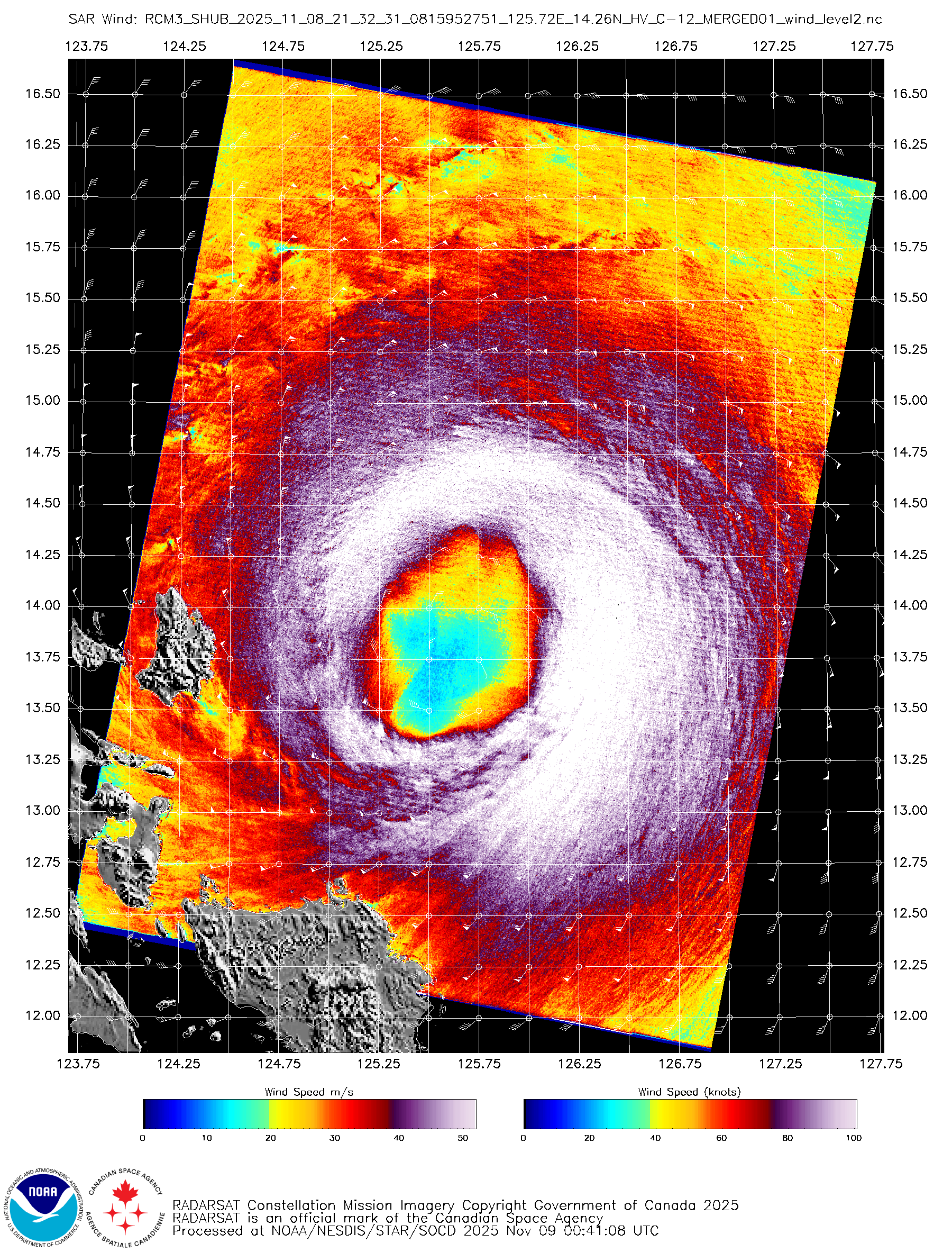
latest pass
0 likes
The posts in this forum are NOT official forecast and should not be used as such. They are just the opinion of the poster and may or may not be backed by sound meteorological data. They are NOT endorsed by any professional institution or storm2k.org. For official information, please refer to RSMC, NHC and NWS products.
-
CrazyC83
- Professional-Met

- Posts: 34315
- Joined: Tue Mar 07, 2006 11:57 pm
- Location: Deep South, for the first time!
Re: WPAC: FUNG-WONG - SuperTyphoon - Discussion
Going with all that data, 105 kt seems a reasonable intensity estimate. The pressure I suspect is quite low given its enormous size though - something like 937 mb.
0 likes
-
mrbagyo
- Category 5
- Posts: 3963
- Age: 33
- Joined: Thu Apr 12, 2012 9:18 am
- Location: 14.13N 120.98E
- Contact:
Re: WPAC: FUNG-WONG - SuperTyphoon - Discussion
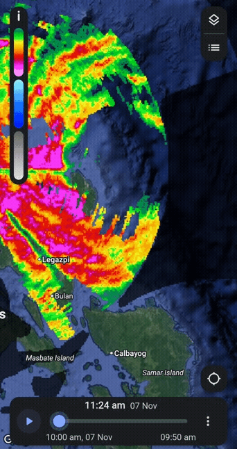
Waves in Dinadiawan are starting to get crazy with the typhoon still very far from it.
Storm surge will be more severe compared to Manyi
https://twitter.com/OreboundImages/status/1987345654533050853
Storm surge will be more severe compared to Manyi
https://twitter.com/OreboundImages/status/1987345654533050853
0 likes
The posts in this forum are NOT official forecast and should not be used as such. They are just the opinion of the poster and may or may not be backed by sound meteorological data. They are NOT endorsed by any professional institution or storm2k.org. For official information, please refer to RSMC, NHC and NWS products.
-
mrbagyo
- Category 5
- Posts: 3963
- Age: 33
- Joined: Thu Apr 12, 2012 9:18 am
- Location: 14.13N 120.98E
- Contact:
Re: WPAC: FUNG-WONG - SuperTyphoon - Discussion
Size comparizon
MAN-YI (2024)

VS
FUNG-WONG (2025)

MAN-YI (2024)
VS
FUNG-WONG (2025)
1 likes
The posts in this forum are NOT official forecast and should not be used as such. They are just the opinion of the poster and may or may not be backed by sound meteorological data. They are NOT endorsed by any professional institution or storm2k.org. For official information, please refer to RSMC, NHC and NWS products.
-
cheezyWXguy

- Category 5
- Posts: 6282
- Joined: Mon Feb 13, 2006 12:29 am
- Location: Dallas, TX
Re: WPAC: FUNG-WONG - SuperTyphoon - Discussion
CrazyC83 wrote:Going with all that data, 105 kt seems a reasonable intensity estimate. The pressure I suspect is quite low given its enormous size though - something like 937 mb.
Am I missing something with the upgrade to “super typhoon”? I thought that label is for 130kt+, but I haven’t seen anything to suggest that
0 likes
-
CrazyC83
- Professional-Met
- Posts: 34315
- Joined: Tue Mar 07, 2006 11:57 pm
- Location: Deep South, for the first time!
Re: WPAC: FUNG-WONG - SuperTyphoon - Discussion
cheezyWXguy wrote:CrazyC83 wrote:Going with all that data, 105 kt seems a reasonable intensity estimate. The pressure I suspect is quite low given its enormous size though - something like 937 mb.
Am I missing something with the upgrade to “super typhoon”? I thought that label is for 130kt+, but I haven’t seen anything to suggest that
PAGASA upgraded it. I don't think JMA or JTWC did.
0 likes
-
mrbagyo
- Category 5
- Posts: 3963
- Age: 33
- Joined: Thu Apr 12, 2012 9:18 am
- Location: 14.13N 120.98E
- Contact:
Re: WPAC: FUNG-WONG - SuperTyphoon - Discussion
0 likes
The posts in this forum are NOT official forecast and should not be used as such. They are just the opinion of the poster and may or may not be backed by sound meteorological data. They are NOT endorsed by any professional institution or storm2k.org. For official information, please refer to RSMC, NHC and NWS products.
-
mrbagyo
- Category 5
- Posts: 3963
- Age: 33
- Joined: Thu Apr 12, 2012 9:18 am
- Location: 14.13N 120.98E
- Contact:
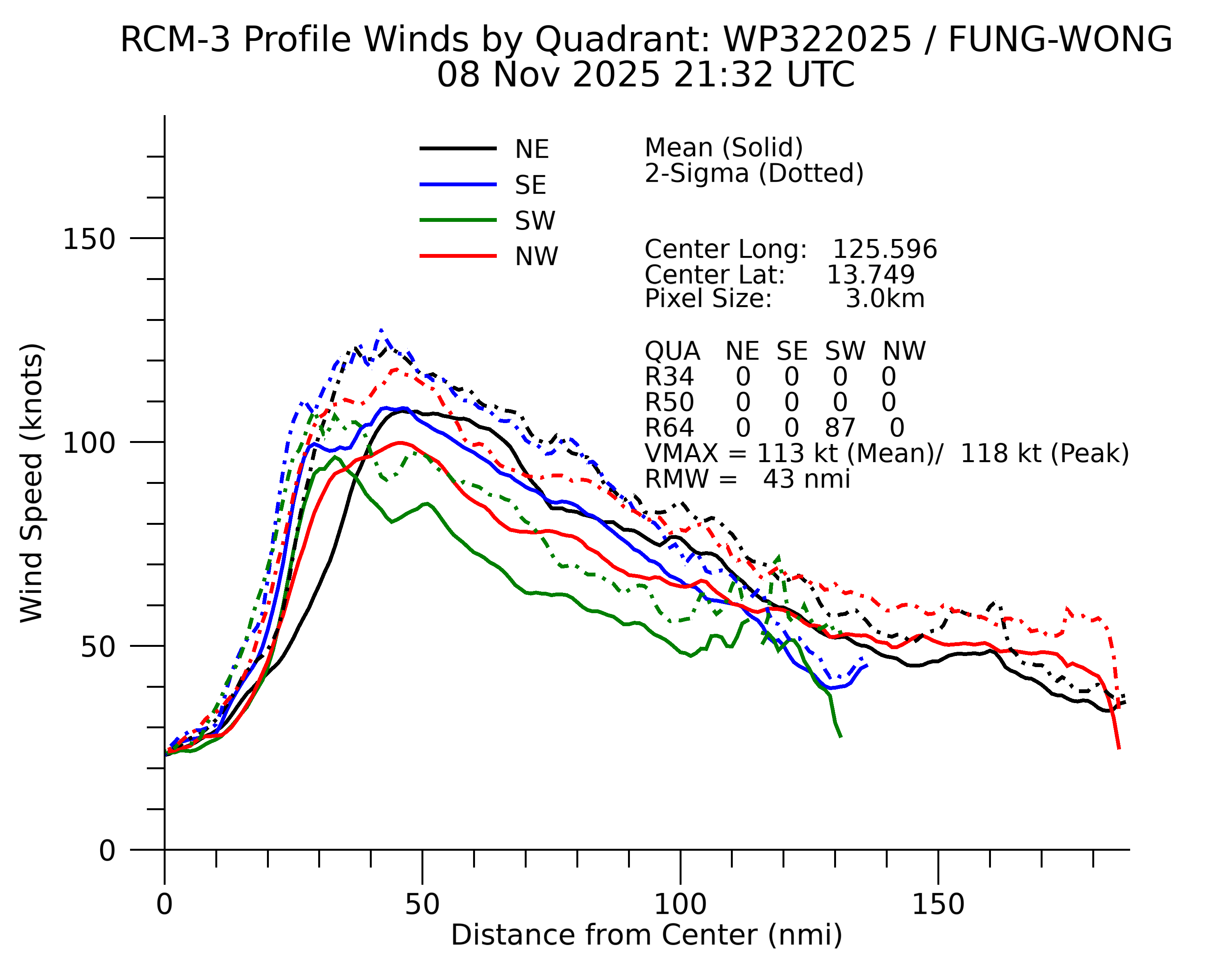
Re: WPAC: FUNG-WONG - SuperTyphoon - Discussion
mrbagyo wrote:latest pass
wind data is now available
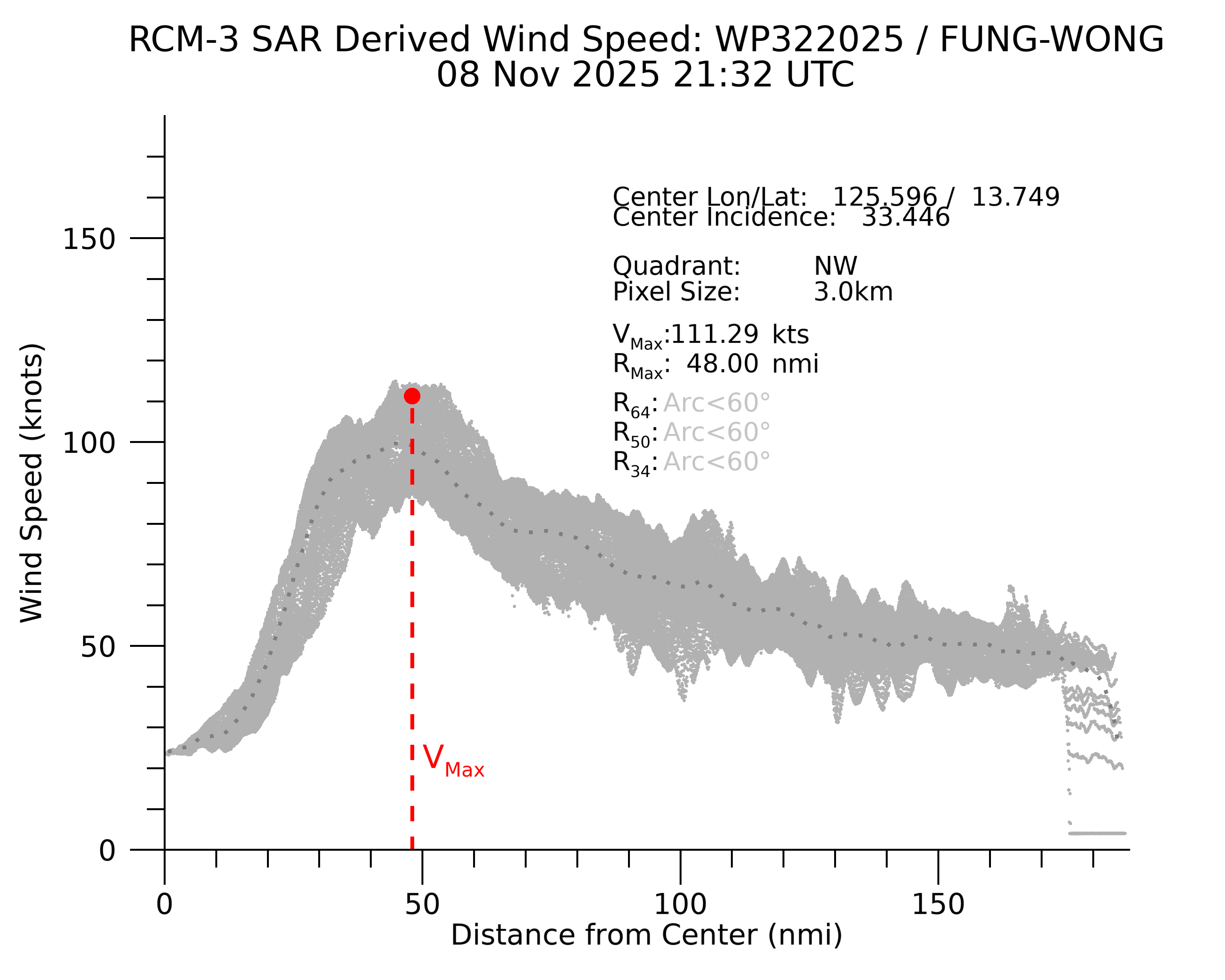
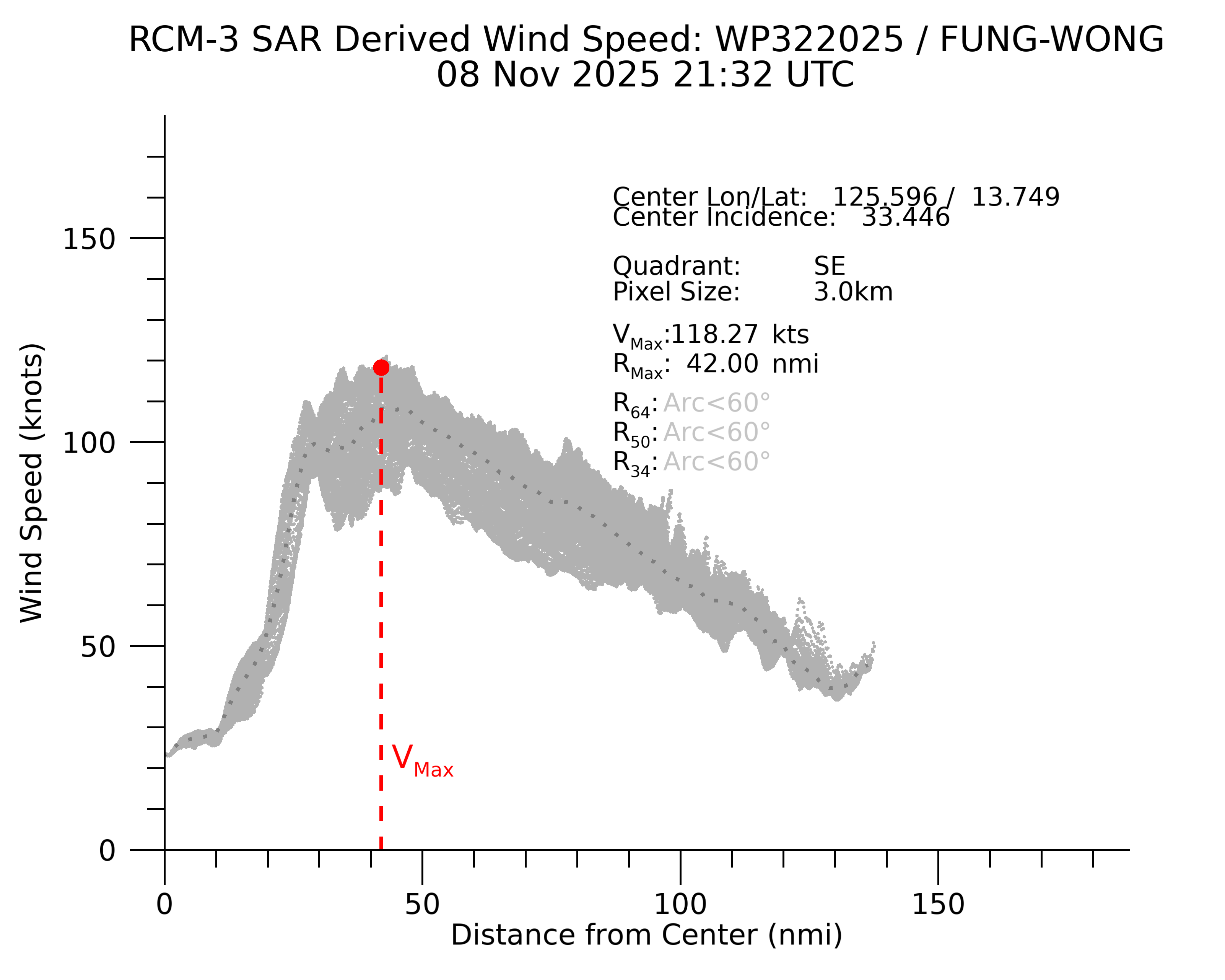
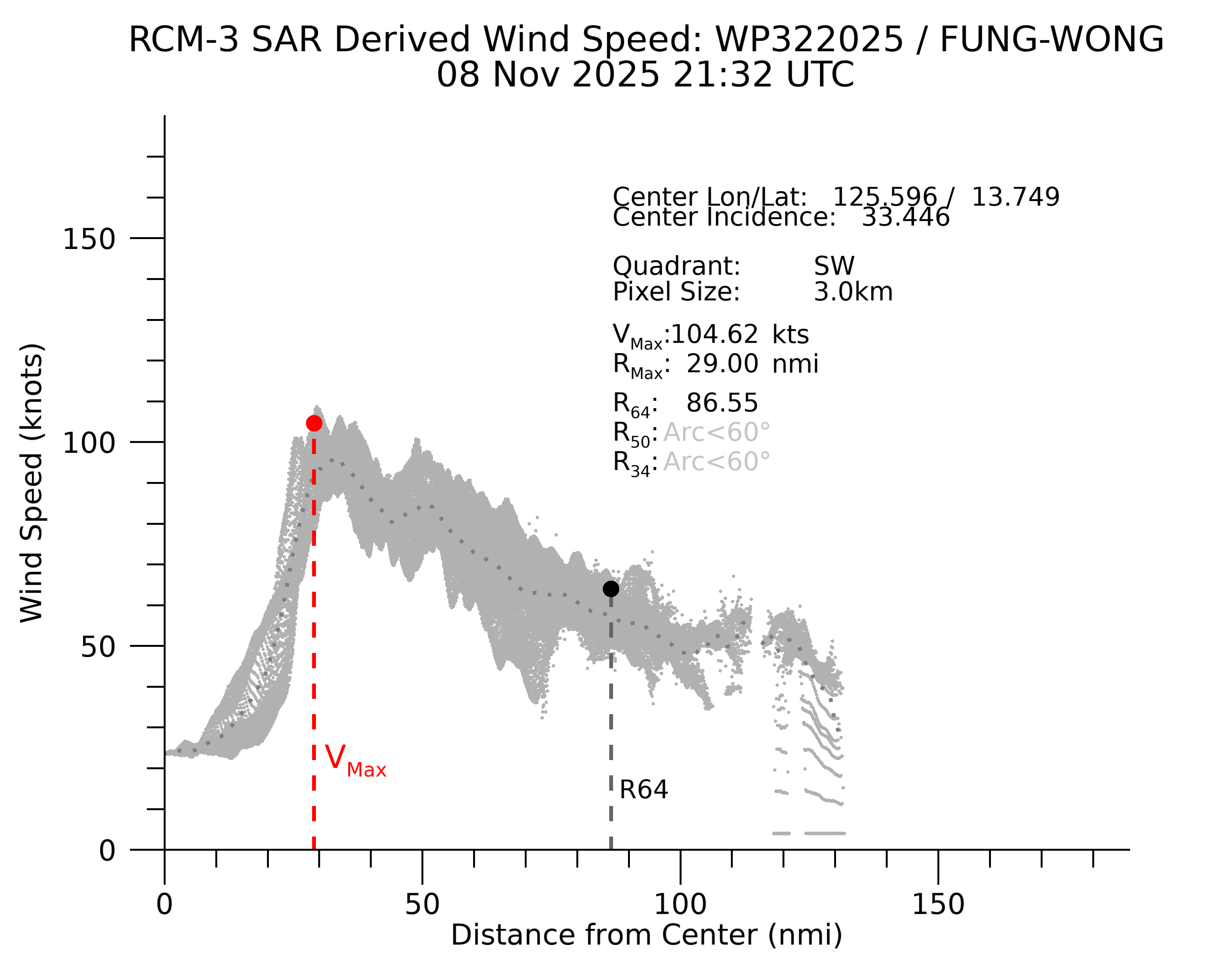
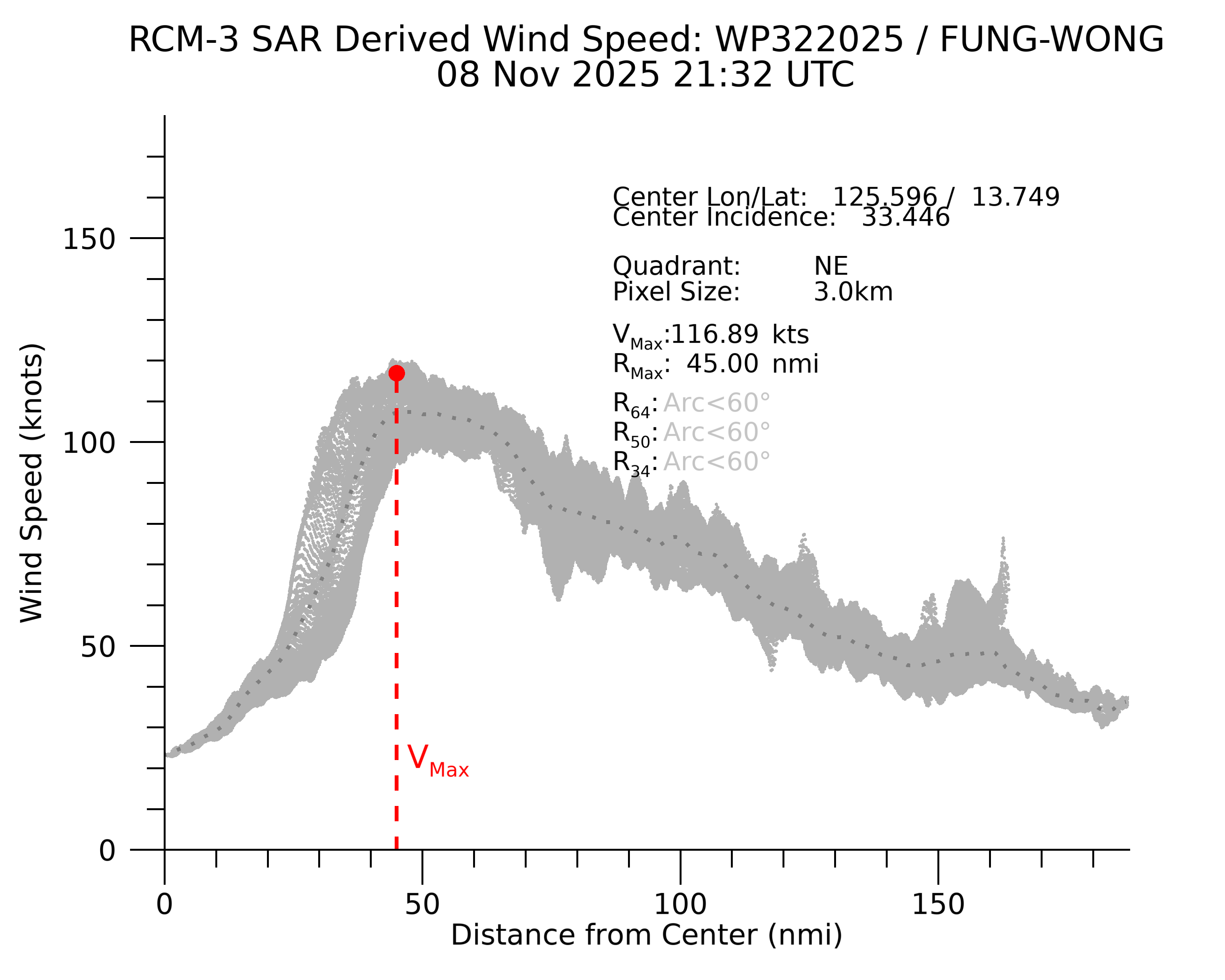

0 likes
The posts in this forum are NOT official forecast and should not be used as such. They are just the opinion of the poster and may or may not be backed by sound meteorological data. They are NOT endorsed by any professional institution or storm2k.org. For official information, please refer to RSMC, NHC and NWS products.
Re: WPAC: FUNG-WONG - SuperTyphoon - Discussion
Up to cat 4

0 likes
ヤンデレ女が寝取られるているのを見たい!!!
ECMWF ensemble NWPAC plots: https://ecmwfensnwpac.imgbb.com/
Multimodel NWPAC plots: https://multimodelnwpac.imgbb.com/
GFS Ensemble NWPAC plots (16 & 35 day forecast): https://gefsnwpac.imgbb.com/
Plots updated automatically
ECMWF ensemble NWPAC plots: https://ecmwfensnwpac.imgbb.com/
Multimodel NWPAC plots: https://multimodelnwpac.imgbb.com/
GFS Ensemble NWPAC plots (16 & 35 day forecast): https://gefsnwpac.imgbb.com/
Plots updated automatically
Who is online
Users browsing this forum: No registered users and 81 guests