WPAC: MAWAR - Post-Tropical

Moderator: S2k Moderators

Message
Author
User avatar
Hayabusa
Category 5
Category 5
Posts: 3738
Joined: Sun Sep 16, 2018 1:05 pm

Re: WPAC: MAWAR - Typhoon

#381 Postby Hayabusa » Fri May 26, 2023 1:43 am

HWRF peaks it at 871.5 mb, while winds at 165 knots :D
Image
Image
0 likes   
ヤンデレ女が寝取られるているのを見たい!!!
ECMWF ensemble NWPAC plots: https://ecmwfensnwpac.imgbb.com/
Multimodel NWPAC plots: https://multimodelnwpac.imgbb.com/
GFS Ensemble NWPAC plots (16 & 35 day forecast): https://gefsnwpac.imgbb.com/
Plots updated automatically

User avatar
Hayabusa
Category 5
Category 5
Posts: 3738
Joined: Sun Sep 16, 2018 1:05 pm

Re: WPAC: MAWAR - Typhoon

#382 Postby Hayabusa » Fri May 26, 2023 1:48 am

Revised 06z
02W MAWAR 230526 0600 15.3N 138.0E WPAC 155 904
0 likes   
ヤンデレ女が寝取られるているのを見たい!!!
ECMWF ensemble NWPAC plots: https://ecmwfensnwpac.imgbb.com/
Multimodel NWPAC plots: https://multimodelnwpac.imgbb.com/
GFS Ensemble NWPAC plots (16 & 35 day forecast): https://gefsnwpac.imgbb.com/
Plots updated automatically

User avatar
ElectricStorm
Category 5
Category 5
Posts: 4526
Age: 23
Joined: Tue Aug 13, 2019 11:23 pm
Location: Skiatook, OK / Norman, OK

Re: WPAC: MAWAR - Typhoon

#383 Postby ElectricStorm » Fri May 26, 2023 1:53 am

155kts is probably a better estimate than 160 but it's not like it matters that much. I still have no idea how they're getting T8.0 though. No way this is an 8.0
1 likes   
I am in no way a professional. Take what I say with a grain of salt as I could be totally wrong. Please refer to the NHC, NWS, or SPC for official information.

Boomer Sooner!

User avatar
Hayabusa
Category 5
Category 5
Posts: 3738
Joined: Sun Sep 16, 2018 1:05 pm

Re: WPAC: MAWAR - Typhoon

#384 Postby Hayabusa » Fri May 26, 2023 2:38 am

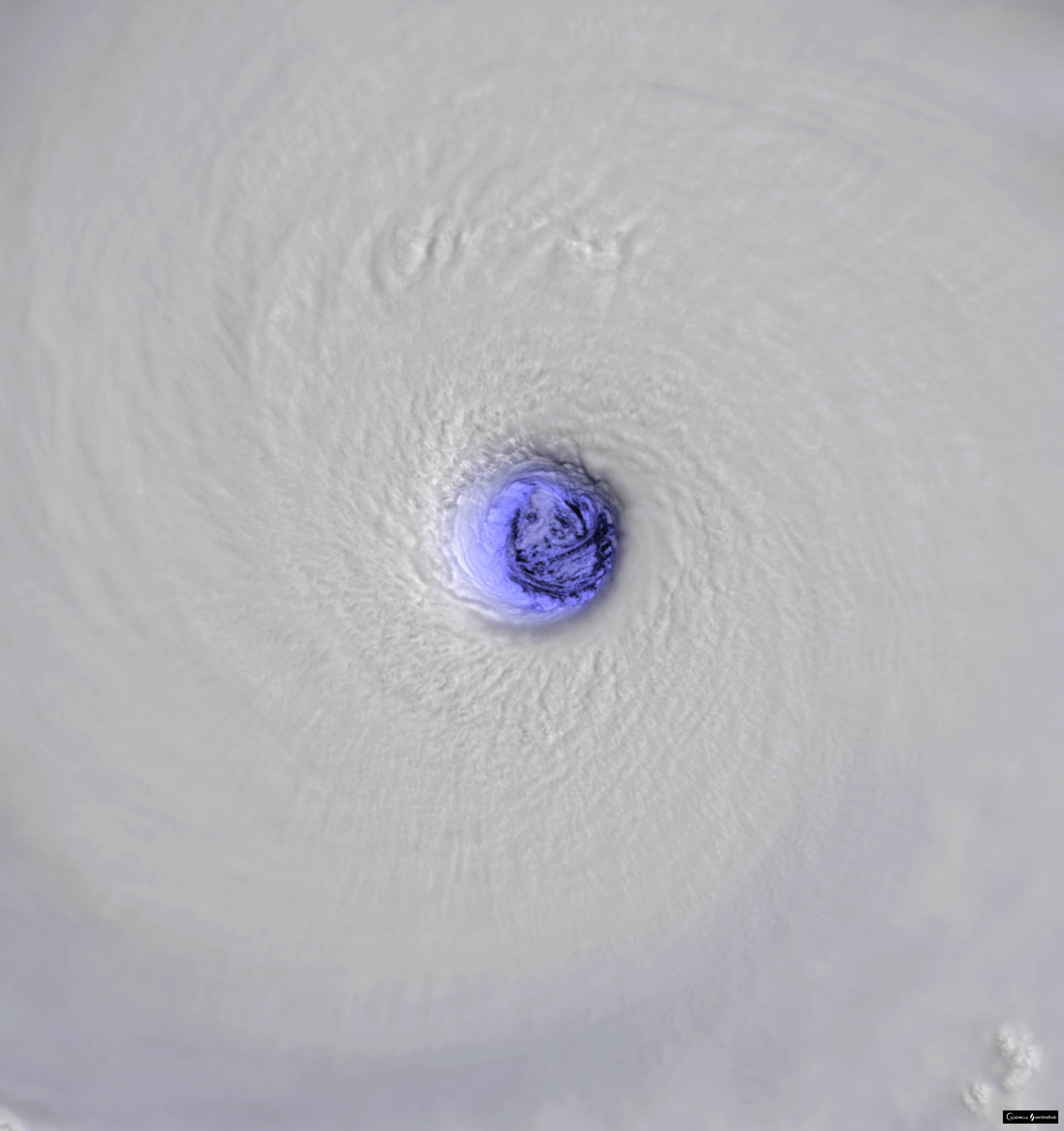
ElectricStorm wrote:155kts is probably a better estimate than 160 but it's not like it matters that much. I still have no idea how they're getting T8.0 though. No way this is an 8.0

JTWC used the visible eye pattern in determining the DT while KNES used the BD/IR eye pattern, so the latter is not getting a T8.0 it must be surrounded by CDG ring.
TXPQ22 KNES 260625
TCSWNP

A. 02W (MAWAR)

B. 26/0530Z

C. 15.3N

D. 138.0E

E. ONE/HIMAWARI-9

F. T7.0/7.5

G. IR/EIR

H. REMARKS...WMG EYE SURROUNDED BY W AND EMBEDDED IN W YIELDS A DT OF
7.0 AFTER A +1.0 EYE ADJUSTMENT. MET IS 7.0 BASED A STEADY TREND OVER
THE LAST 24 HOURS. PT AGREES WITH MET AND DT. THE FT IS BASED ON THE DT.

I. ADDL POSITIONS

NIL


...NGUYEN


As for why JTWC used the visible eye technique instead of the IR technique, I don't know
0 likes   
ヤンデレ女が寝取られるているのを見たい!!!
ECMWF ensemble NWPAC plots: https://ecmwfensnwpac.imgbb.com/
Multimodel NWPAC plots: https://multimodelnwpac.imgbb.com/
GFS Ensemble NWPAC plots (16 & 35 day forecast): https://gefsnwpac.imgbb.com/
Plots updated automatically

User avatar
Hayabusa
Category 5
Category 5
Posts: 3738
Joined: Sun Sep 16, 2018 1:05 pm

Re: WPAC: MAWAR - Typhoon

#385 Postby Hayabusa » Fri May 26, 2023 4:12 am

09Z used IR, so DT is 7.5 but CI is still held at 8.0
TPPN10 PGTW 260902

A. SUPER TYPHOON 02W (MAWAR)

B. 26/0830Z

C. 15.42N

D. 137.31E

E. ONE/GK2A

F. T7.5/8.0/S0.0/24HRS STT: W0.5/03HRS

G. IR/EIR

H. REMARKS: 01A/PBO EYE/ANMTN. WMG EYE SURROUNDED BY W YIELDS AN E#
OF 6.0. ADDED 1.0 EYE ADJUSTMENT FOR W, AND ADDED 0.5 FOR BF, TO
YIELD A DT OF 7.5. MET YIELDS 8.0. PT YIELDS 7.5. DBO DT.

I. ADDITIONAL POSITIONS: NONE


RAE
0 likes   
ヤンデレ女が寝取られるているのを見たい!!!
ECMWF ensemble NWPAC plots: https://ecmwfensnwpac.imgbb.com/
Multimodel NWPAC plots: https://multimodelnwpac.imgbb.com/
GFS Ensemble NWPAC plots (16 & 35 day forecast): https://gefsnwpac.imgbb.com/
Plots updated automatically

Guamphoon
Tropical Low
Tropical Low
Posts: 31
Joined: Wed Jul 04, 2018 11:57 am
Location: Tamuning, Guam

Re: WPAC: MAWAR - Typhoon

#386 Postby Guamphoon » Fri May 26, 2023 4:15 am

sikkar wrote:Top 5 best looking canes. Big relief it's in the middle of no where. Thankfully no deaths in Guam but they have a long road for recovery...


Unfortunately, that is no longer the case as of today. There are some people missing at sea,

2 men went swimming to a reef island, on Wednesday, at around 2 in the afternoon. It was insane weather let me tell you. After a week of authorities telling everyone to stay out of the water. One made it to the island, the other was swept out.

The first ongoing rescue, which began at 10 a.m. Thursday stems from reports that an 18-year-old and another adult male went swimming toward Alupang Island on Wednesday at around 2 p.m. They reportedly got swept out to sea by large waves north of the island by Rick's Reef, Reilly stated in a message to local media.


"According to the man, he tried, but was unable to pull the other swimmer from the rough waters approximately 30 yards from the island. With the weather deteriorating rapidly, the man decided to remain on the island through the duration of Typhoon Mawar," Reilly said.

The 18-year-old wasn't able to return to shore until Thursday to report the incident, and units were dispatched to conduct shoreline and reef line searches today.

At first light Friday, the search continued, Reilly added.


https://www.postguam.com/news/gfd-searc ... 892c5.html

Alupang Island, for reference, where he apparently spent the storm. Wild.

Image

Its an easy swim in normal times, but that is super exposed in stormy weather.
0 likes   

User avatar
Hayabusa
Category 5
Category 5
Posts: 3738
Joined: Sun Sep 16, 2018 1:05 pm

Re: WPAC: MAWAR - Typhoon

#387 Postby Hayabusa » Fri May 26, 2023 4:54 am

GFS 06Z peaks at 871 mb
Image
1 likes   
ヤンデレ女が寝取られるているのを見たい!!!
ECMWF ensemble NWPAC plots: https://ecmwfensnwpac.imgbb.com/
Multimodel NWPAC plots: https://multimodelnwpac.imgbb.com/
GFS Ensemble NWPAC plots (16 & 35 day forecast): https://gefsnwpac.imgbb.com/
Plots updated automatically

User avatar
Hurricane2022
Category 4
Category 4
Posts: 915
Joined: Tue Aug 23, 2022 11:38 pm
Location: Araçatuba, Brazil

Re: WPAC: MAWAR - Typhoon

#388 Postby Hurricane2022 » Fri May 26, 2023 5:19 am

Im posting this at 10:20 UTC
02W MAWAR 230526 1200 15.6N 136.7E WPAC 150 904

Image
0 likes   
Sorry for the bad English sometimes...!
For reliable and detailed information for any meteorological phenomenon, please consult the National Hurricane Center, Joint Typhoon Warning Center , or your local Meteo Center.

--------

Una cvm Christo, pro Christo, et in Christo. Sit nomen Domini benedictvm.

dexterlabio
Category 5
Category 5
Posts: 3406
Joined: Sat Oct 24, 2009 11:50 pm

Re: WPAC: MAWAR - Typhoon

#389 Postby dexterlabio » Fri May 26, 2023 5:38 am

I imagine the current EWRC will be more of an eyewall meld, which usually happens in the upper-echelon tropical cyclones over favorable environment (i.e. Haiyan).
2 likes   
Personal Forecast Disclaimer:
The posts in this forum are NOT official forecast and should not be used as such. They are just the opinion of the poster and may or may not be backed by sound meteorological data. They are NOT endorsed by any professional institution or storm2k.org. For official information, please refer to the NHC and NWS products.

User avatar
mrbagyo
Category 5
Category 5
Posts: 3614
Age: 31
Joined: Thu Apr 12, 2012 9:18 am
Location: 14.13N 120.98E
Contact:

Re: WPAC: MAWAR - Typhoon

#390 Postby mrbagyo » Fri May 26, 2023 6:33 am

dexterlabio wrote:I imagine the current EWRC will be more of an eyewall meld, which usually happens in the upper-echelon tropical cyclones over favorable environment (i.e. Haiyan).


the inner and outer eyewall are so closely spaced that they might just indeed meld together.
2 likes   
The posts in this forum are NOT official forecast and should not be used as such. They are just the opinion of the poster and may or may not be backed by sound meteorological data. They are NOT endorsed by any professional institution or storm2k.org. For official information, please refer to RSMC, NHC and NWS products.

User avatar
Hayabusa
Category 5
Category 5
Posts: 3738
Joined: Sun Sep 16, 2018 1:05 pm

Re: WPAC: MAWAR - Typhoon

#391 Postby Hayabusa » Fri May 26, 2023 7:17 am

02W MAWAR 230526 1200 15.7N 136.6E WPAC 145 904

TPPN10 PGTW 261213

A. SUPER TYPHOON 02W (MAWAR)

B. 26/1150Z

C. 15.69N

D. 136.49E

E. ONE/GK2A

F. T7.5/8.0/S0.0/24HRS STT: S0.0/03HRS

G. IR/EIR

H. REMARKS: 01A/PBO EYE/ANMTN. WMG EYE SURROUNDED BY W YIELDS AN E#
OF 6.0. ADDED 1.0 EYE ADJUSTMENT FOR W, AND ADDED 0.5 FOR BF, TO
YIELD A DT OF 7.5. PT YIELDS 7.5. NO MET DUE TO NEW TREND.

I. ADDITIONAL POSITIONS:
26/0620Z 15.32N 137.82E SSMS
26/0817Z 15.38N 137.38E SSMS
26/0855Z 15.47N 137.35E SSMS


RAE

CCA:
TPPN10 PGTW 261221 COR

A. SUPER TYPHOON 02W (MAWAR)

B. 26/1151Z

C. 15.69N

D. 136.49E

E. ONE/GK2A

F. T7.0/8.0/W0.5/24HRS STT: W0.5/03HRS

G. IR/EIR

H. REMARKS: 01A/PBO EYE/ANMTN. WMG EYE SURROUNDED BY B YIELDS AN E#
OF 5.5. ADDED 1.0 EYE ADJUSTMENT FOR W, AND ADDED 0.5 FOR BF, TO
YIELD A DT OF 7.0. PT YIELDS 7.5. NO MET DUE TO NEW TREND.

I. ADDITIONAL POSITIONS:
26/0817Z 15.38N 137.38E SSMS
26/0855Z 15.47N 137.35E SSMS


RAE
0 likes   
ヤンデレ女が寝取られるているのを見たい!!!
ECMWF ensemble NWPAC plots: https://ecmwfensnwpac.imgbb.com/
Multimodel NWPAC plots: https://multimodelnwpac.imgbb.com/
GFS Ensemble NWPAC plots (16 & 35 day forecast): https://gefsnwpac.imgbb.com/
Plots updated automatically

User avatar
doomhaMwx
Category 5
Category 5
Posts: 2398
Age: 25
Joined: Tue Apr 18, 2017 4:01 am
Location: Baguio/Benguet, Philippines
Contact:

Re: WPAC: MAWAR - Typhoon

#392 Postby doomhaMwx » Fri May 26, 2023 7:53 am

6 likes   
Like my content? Consider giving a tip.

User avatar
InfernoFlameCat
Category 5
Category 5
Posts: 1966
Age: 21
Joined: Mon Dec 14, 2020 10:52 am
Location: Buford, GA

Re: WPAC: MAWAR - Typhoon

#393 Postby InfernoFlameCat » Fri May 26, 2023 8:27 am

I think the JTWC is doing good with this storm. They get hate often but never love for when they are doing a good job. Hats off to the JTWC on this one.
0 likes   
I am by no means a professional. DO NOT look at my forecasts for official information or make decisions based on what I post.

Goal: to become a registered expert over tropical and subtropical cyclones.

User avatar
Hayabusa
Category 5
Category 5
Posts: 3738
Joined: Sun Sep 16, 2018 1:05 pm

Re: WPAC: MAWAR - Typhoon

#394 Postby Hayabusa » Fri May 26, 2023 8:37 am

It's the NAVGEM but if it comes true, bad news for the Babuyan/Batanes islands, it makes Mawar stationary directly over it for almost 2 days
Image
0 likes   
ヤンデレ女が寝取られるているのを見たい!!!
ECMWF ensemble NWPAC plots: https://ecmwfensnwpac.imgbb.com/
Multimodel NWPAC plots: https://multimodelnwpac.imgbb.com/
GFS Ensemble NWPAC plots (16 & 35 day forecast): https://gefsnwpac.imgbb.com/
Plots updated automatically

User avatar
aspen
Category 5
Category 5
Posts: 8057
Joined: Sat Oct 12, 2019 7:10 pm
Location: Connecticut, USA

Re: WPAC: MAWAR - Typhoon

#395 Postby aspen » Fri May 26, 2023 9:25 am

Hayabusa wrote:HWRF peaks it at 871.5 mb, while winds at 165 knots :D
https://i.imgur.com/lLaTl7m.png
https://i.imgur.com/sIwpCvR.png

It took long enough to get a storm to break the new HWRF lol. I’m doubtful Mawar ever restrengthens with an ongoing EWRC/meld and unfavorable conditions looming on the horizon. It could level out as a 130-140 kt super before entering a more pronounced weakening phase later this weekend.
0 likes   
Irene '11 Sandy '12 Hermine '16 5/15/2018 Derecho Fay '20 Isaias '20 Elsa '21 Henri '21 Ida '21

I am only a meteorology enthusiast who knows a decent amount about tropical cyclones. Look to the professional mets, the NHC, or your local weather office for the best information.

User avatar
canebeard
Tropical Depression
Tropical Depression
Posts: 74
Joined: Sun Jul 05, 2009 4:06 pm
Contact:

Re: WPAC: MAWAR - Typhoon

#396 Postby canebeard » Fri May 26, 2023 9:42 am

0 likes   
List of 79 tropical cyclones intercepted by Richard Horodner:
http://www.canebeard.com/page/page/572246.htm
former storm2k screenname Beoumont 2009+

User avatar
canebeard
Tropical Depression
Tropical Depression
Posts: 74
Joined: Sun Jul 05, 2009 4:06 pm
Contact:

Re: WPAC: MAWAR - Typhoon

#397 Postby canebeard » Fri May 26, 2023 10:11 am

1 likes   
List of 79 tropical cyclones intercepted by Richard Horodner:
http://www.canebeard.com/page/page/572246.htm
former storm2k screenname Beoumont 2009+

dexterlabio
Category 5
Category 5
Posts: 3406
Joined: Sat Oct 24, 2009 11:50 pm

Re: WPAC: MAWAR - Typhoon

#398 Postby dexterlabio » Fri May 26, 2023 10:15 am

aspen wrote:
Hayabusa wrote:HWRF peaks it at 871.5 mb, while winds at 165 knots :D
https://i.imgur.com/lLaTl7m.png
https://i.imgur.com/sIwpCvR.png

It took long enough to get a storm to break the new HWRF lol. I’m doubtful Mawar ever restrengthens with an ongoing EWRC/meld and unfavorable conditions looming on the horizon. It could level out as a 130-140 kt super before entering a more pronounced weakening phase later this weekend.


But it is only about to enter the area of highest OHC. Atmospheric conditions, however, will be marginal past 130E longitude as it tracks further westward. Conditions will be very unfavorable once it tracks more poleward/approaches 19N-20N latitude.

With the aid of DMax and conducive environment, I believe Mawar will have another successful EWRC in the next few hours and regain its peak strength, or maybe even set a new peak.
0 likes   
Personal Forecast Disclaimer:
The posts in this forum are NOT official forecast and should not be used as such. They are just the opinion of the poster and may or may not be backed by sound meteorological data. They are NOT endorsed by any professional institution or storm2k.org. For official information, please refer to the NHC and NWS products.

User avatar
Yellow Evan
Professional-Met
Professional-Met
Posts: 15951
Age: 25
Joined: Fri Jul 15, 2011 12:48 pm
Location: Henderson, Nevada/Honolulu, HI
Contact:

Re: WPAC: MAWAR - Typhoon

#399 Postby Yellow Evan » Fri May 26, 2023 10:41 am

Given the nuclear eye temperatures on IR and WV, which isn’t something IR Dvorak and ADT take into account, I actually don’t think 170 knots is too far off. We’ve seen these techniques massively underperform with upper elechon storms outside high tropopause environments before and other techniques don’t really have any reputable history with storm’s of this magnitude.
3 likes   

Sciencerocks
Category 5
Category 5
Posts: 7284
Age: 38
Joined: Thu Jul 06, 2017 1:51 am

Re: WPAC: MAWAR - Typhoon

#400 Postby Sciencerocks » Fri May 26, 2023 11:21 am

Image
1 likes   


Return to “2023”

Who is online

Users browsing this forum: No registered users and 6 guests