SIO: CHIDO - Post-Tropical
Moderator: S2k Moderators
-
Hurricane2022

- Category 5

- Posts: 1538
- Joined: Tue Aug 23, 2022 11:38 pm
- Location: Araçatuba, Brazil
Re: SIO: CHIDO - Intense Tropical Cyclone
Holy cowww


3 likes
Sorry for the bad English sometimes...!
For reliable and detailed information for any meteorological phenomenon, please consult the National Hurricane Center, Joint Typhoon Warning Center , or your local Meteo Center.
--------
Una cvm Christo, pro Christo, et in Christo. Sit nomen Domini benedictvm.
For reliable and detailed information for any meteorological phenomenon, please consult the National Hurricane Center, Joint Typhoon Warning Center , or your local Meteo Center.
--------
Una cvm Christo, pro Christo, et in Christo. Sit nomen Domini benedictvm.
-
Hurricane2022
- Category 5
- Posts: 1538
- Joined: Tue Aug 23, 2022 11:38 pm
- Location: Araçatuba, Brazil
Re: SIO: CHIDO - Intense Tropical Cyclone
From MFR's latest discussion.
WHEN CHIDO PASSED OVER AGALEGA AT 1830UTC, THE PRESSURE RECORDED WAS
950.8HPA ACCORDING TO THE MAURITIUS METEOROLOGICAL SERVICE.
950.8HPA ACCORDING TO THE MAURITIUS METEOROLOGICAL SERVICE.
0 likes
Sorry for the bad English sometimes...!
For reliable and detailed information for any meteorological phenomenon, please consult the National Hurricane Center, Joint Typhoon Warning Center , or your local Meteo Center.
--------
Una cvm Christo, pro Christo, et in Christo. Sit nomen Domini benedictvm.
For reliable and detailed information for any meteorological phenomenon, please consult the National Hurricane Center, Joint Typhoon Warning Center , or your local Meteo Center.
--------
Una cvm Christo, pro Christo, et in Christo. Sit nomen Domini benedictvm.
Re: SIO: CHIDO - Intense Tropical Cyclone
TPXS11 PGTW 120601
A. TROPICAL CYCLONE 04S (CHIDO)
B. 12/0530Z
C. 10.53S
D. 54.53E
E. ONE/MET9
F. T7.0/7.0/D2.5/24HRS STT: D0.5/03HRS
G. IR/EIR/VIS/MSI
H. REMARKS: 07A/PBO IRREG EYE/ANMTN. WMG EYE SURROUNDED BY W YIELDS
AN E# OF 6.0. ADDED 1.0 EYE ADJUSTMENT FOR W, TO YIELD A DT OF 7.0.
MET YIELDS 6.0. PT YIELDS 6.5. DBO DT.
I. ADDITIONAL POSITIONS: NONE
EL-NAZLY
0 likes

-
MarioProtVI
- Category 4

- Posts: 935
- Age: 24
- Joined: Sun Sep 29, 2019 7:33 pm
- Location: New Jersey
Re: SIO: CHIDO - Intense Tropical Cyclone
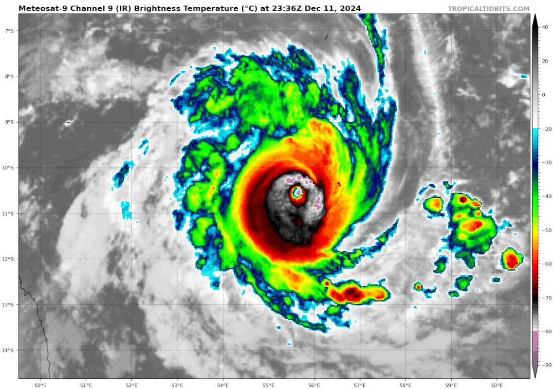
I was only briefly aware of this storm yesterday and it was only expected to peak ~75-80 kt. Got sidetracked by college for a bit and basically wrote it off as another C1/2 from the SWIO, and now 24h it’s on the doorstep of, if arguably already is by now a Cat 5 (likely is with that eye temperature right now). What the actual hell. It’s also not totally coincidental that just 5 years ago in 2019 around this time give or take a few days we had Ambali which also underwent EI in December to a Cat 5. Crazy stuff
3 likes

Re: SIO: CHIDO - Intense Tropical Cyclone
I think that at this point this is more than just a PTC  .
.

3 likes
-
WaveBreaking

- Category 2

- Posts: 578
- Joined: Sun Jun 30, 2024 11:33 am
- Location: US
Re: SIO: CHIDO - Intense Tropical Cyclone
About to clip the N tip of Madagascar


Last edited by WaveBreaking on Thu Dec 12, 2024 8:26 am, edited 1 time in total.
1 likes
I am NOT a professional meteorologist, so take all of my posts with a grain of salt. My opinions are mine and mine alone.
-
WaveBreaking
- Category 2
- Posts: 578
- Joined: Sun Jun 30, 2024 11:33 am
- Location: US
Re: SIO: CHIDO - Intense Tropical Cyclone
Is it too early for me to call the infamous A-word for Chido? It’s certainly getting there.

1 likes
I am NOT a professional meteorologist, so take all of my posts with a grain of salt. My opinions are mine and mine alone.


Re: SIO: CHIDO - Intense Tropical Cyclone
Some wild SAR passes, 13 hours apart. You can see the outer wind maximum developing as the ERC progresses:
 |  |
 |  |
2 likes
-
Hurricane2022
- Category 5
- Posts: 1538
- Joined: Tue Aug 23, 2022 11:38 pm
- Location: Araçatuba, Brazil
Re: SIO: CHIDO - Intense Tropical Cyclone
https://x.com/zeb199818/status/1867171384197358027
https://x.com/zeb199818/status/1867176981856768147
https://x.com/zeb199818/status/1867185217569763645
We likely had Category 5 VITC Chido this afternoon.
https://x.com/zeb199818/status/1867176981856768147
https://x.com/zeb199818/status/1867185217569763645
We likely had Category 5 VITC Chido this afternoon.
0 likes
Sorry for the bad English sometimes...!
For reliable and detailed information for any meteorological phenomenon, please consult the National Hurricane Center, Joint Typhoon Warning Center , or your local Meteo Center.
--------
Una cvm Christo, pro Christo, et in Christo. Sit nomen Domini benedictvm.
For reliable and detailed information for any meteorological phenomenon, please consult the National Hurricane Center, Joint Typhoon Warning Center , or your local Meteo Center.
--------
Una cvm Christo, pro Christo, et in Christo. Sit nomen Domini benedictvm.
-
Hurricane2022
- Category 5
- Posts: 1538
- Joined: Tue Aug 23, 2022 11:38 pm
- Location: Araçatuba, Brazil
Re: SIO: CHIDO - Intense Tropical Cyclone
0 likes
Sorry for the bad English sometimes...!
For reliable and detailed information for any meteorological phenomenon, please consult the National Hurricane Center, Joint Typhoon Warning Center , or your local Meteo Center.
--------
Una cvm Christo, pro Christo, et in Christo. Sit nomen Domini benedictvm.
For reliable and detailed information for any meteorological phenomenon, please consult the National Hurricane Center, Joint Typhoon Warning Center , or your local Meteo Center.
--------
Una cvm Christo, pro Christo, et in Christo. Sit nomen Domini benedictvm.

-
WaveBreaking
- Category 2
- Posts: 578
- Joined: Sun Jun 30, 2024 11:33 am
- Location: US
Re: SIO: CHIDO - Intense Tropical Cyclone


0 likes
I am NOT a professional meteorologist, so take all of my posts with a grain of salt. My opinions are mine and mine alone.
-
Hurricane2022
- Category 5
- Posts: 1538
- Joined: Tue Aug 23, 2022 11:38 pm
- Location: Araçatuba, Brazil
Re: SIO: CHIDO - Intense Tropical Cyclone
ALTHOUGH RAPID INTENSIFICATION (RI) GUIDANCE DID NOT TRIGGER ON THE LATEST RUN, THERE ARE ANOTHER 12 HOURS TO GO BEFORE THE RI THREAT CAN BE ELIMINATED AND WE CAN BE CONFIDENT THAT THE GHOST OF FREDDY WILL NOT RISE AGAIN.
*from jtwc
1 likes
Sorry for the bad English sometimes...!
For reliable and detailed information for any meteorological phenomenon, please consult the National Hurricane Center, Joint Typhoon Warning Center , or your local Meteo Center.
--------
Una cvm Christo, pro Christo, et in Christo. Sit nomen Domini benedictvm.
For reliable and detailed information for any meteorological phenomenon, please consult the National Hurricane Center, Joint Typhoon Warning Center , or your local Meteo Center.
--------
Una cvm Christo, pro Christo, et in Christo. Sit nomen Domini benedictvm.
-
cycloneye

- Admin

- Posts: 145223
- Age: 68
- Joined: Thu Oct 10, 2002 10:54 am
- Location: San Juan, Puerto Rico
Re: SIO: CHIDO - Intense Tropical Cyclone
INTENSE TROPICAL CYCLONE number 4
(CHIDO)
Maximum winds (averaged over 10 minutes) estimated at sea: 175 km/h.
Estimated maximum gusts at sea: 250 km/h.
Estimated central pressure: 957 hPa.
Position on December 14 at 1 p.m. local time: 12.8 South / 44.8 East.
Distance from the Reunion coast: 1435 km to the sector: NORTH-WEST
Distance from Mayotte: 40 km to sector: WEST
Movement: WEST-SOUTH-WEST, at 28 km/h.
System Information:
- Intense tropical cyclone CHIDO is hitting Mayotte. The eye of the cyclone passed over the north and northwest of Grande-Terre late this morning. Extreme cyclonic conditions associated with the cyclone's eye wall will continue for a few more hours early this afternoon. The observed gusts reached at least 226 km/h at Pamandzi airport. These devastating wind conditions are exceptional and exceed the intensity of Kamisy (1984) and can be comparable to historical cyclones such as that of 1934. The eye is starting to move away to the west of Mayotte. Heavy rains generating flooding as well as dangerous sea conditions with coastal submersions also accompany the meteor. A fairly rapid improvement in weather conditions is expected from the end of the afternoon as the cyclone moves away to the west.
- CHIDO will remain a particularly dangerous intense tropical cyclone over the next 24 hours as it crosses the northern Mozambique Channel. In addition to Mayotte, it passes south of the Comoros this Saturday and tonight and is expected to land early Sunday morning in northern Mozambique.
- For the Comoros, CHIDO will pass close to the south of the islands of Anjouan and Moheli. The wind deterioration will be less violent than for Mayotte but should generate strong or even destructive winds. Heavy rains that could cause flooding are likely and marine submersion is possible. Residents are invited to follow the evolution of the forecasts through their national meteorological service. A gradual improvement is expected on Sunday.
- For Mozambique, CHIDO is expected to land in the south of Cabo Delgado province near the border with Nampula province, close to the south of Pemba. Damaging winds and dangerous seas are expected on the coast from Saturday night to Sunday and all morning on Sunday. Heavy rains will also affect the coastal provinces, gradually progressing into the interior provinces (Niassa, Tete and Zambezia).
- The remnants of CHIDO are also expected to affect southern Malawi from Sunday night into Monday and during the day on Monday, bringing heavy rain and strong wind gusts to the terrain. The system is expected to gradually dissipate on Tuesday in the southern African interior near Zimbabwe.
0 likes
Visit the Caribbean-Central America Weather Thread where you can find at first post web cams,radars
and observations from Caribbean basin members Click Here
and observations from Caribbean basin members Click Here
-
cycloneye
- Admin
- Posts: 145223
- Age: 68
- Joined: Thu Oct 10, 2002 10:54 am
- Location: San Juan, Puerto Rico
Re: SIO: CHIDO - Intense Tropical Cyclone
0 likes
Visit the Caribbean-Central America Weather Thread where you can find at first post web cams,radars
and observations from Caribbean basin members Click Here
and observations from Caribbean basin members Click Here
-
mrbagyo

- Category 5
- Posts: 3715
- Age: 33
- Joined: Thu Apr 12, 2012 9:18 am
- Location: 14.13N 120.98E
- Contact:
Re: SIO: CHIDO - Intense Tropical Cyclone
0 likes
The posts in this forum are NOT official forecast and should not be used as such. They are just the opinion of the poster and may or may not be backed by sound meteorological data. They are NOT endorsed by any professional institution or storm2k.org. For official information, please refer to RSMC, NHC and NWS products.
-
cycloneye
- Admin
- Posts: 145223
- Age: 68
- Joined: Thu Oct 10, 2002 10:54 am
- Location: San Juan, Puerto Rico
Re: SIO: CHIDO - Intense Tropical Cyclone
0 likes
Visit the Caribbean-Central America Weather Thread where you can find at first post web cams,radars
and observations from Caribbean basin members Click Here
and observations from Caribbean basin members Click Here
-
StormWeather

- Tropical Storm

- Posts: 120
- Joined: Wed Jun 05, 2024 2:34 pm
Re: SIO: CHIDO - Intense Tropical Cyclone
Hurricane2022 wrote:ALTHOUGH RAPID INTENSIFICATION (RI) GUIDANCE DID NOT TRIGGER ON THE LATEST RUN, THERE ARE ANOTHER 12 HOURS TO GO BEFORE THE RI THREAT CAN BE ELIMINATED AND WE CAN BE CONFIDENT THAT THE GHOST OF FREDDY WILL NOT RISE AGAIN.
*from jtwc
The ghost of Freddy??!?? Huh? Where did that come from?
0 likes
Just your average cyclone tracker
Cyclones experienced;
Debby 24’
Cyclones experienced;
Debby 24’

Re: SIO: CHIDO - Intense Tropical Cyclone
https://x.com/gegeYT976/status/1867905173542314397
Pretty sure this person was the original source FYI, this particular link is a longer video
0 likes
Who is online
Users browsing this forum: No registered users and 4 guests