
91S INVEST 251207 0000 5.3S 92.6E SHEM 15 1010
SIO: BAKUNG - Tropical Cyclone
Moderators: hurricanetrack, S2k Moderators
Forum rules

The posts in this forum are NOT official forecast and should not be used as such. They are just the opinion of the poster and may or may not be backed by sound meteorological data. They are NOT endorsed by any professional institution or STORM2K.
SIO: BAKUNG - Tropical Cyclone
Last edited by Subtrop on Fri Dec 12, 2025 7:12 am, edited 1 time in total.
0 likes
Re: SIO: BAKUNG - Tropical Cyclone
Tropical Cyclone Bakung began to form 91 S on December 6, 2025 at 07:00 WIB in the Indian Ocean, southwest of Lampung.
0 likes

Re: SIO: BAKUNG - Tropical Cyclone
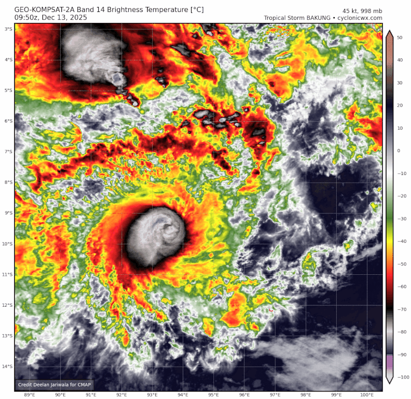
This is officially a 45 kt TS.
0 likes
TC naming lists: retirements and intensity
Most aggressive Advisory #1's in North Atlantic (cr. kevin for starting the list)
Most aggressive Advisory #1's in North Atlantic (cr. kevin for starting the list)
-
StormWeather

- Category 1

- Posts: 473
- Joined: Wed Jun 05, 2024 2:34 pm
Re: SIO: BAKUNG - Tropical Cyclone
I would think that this is at least 65-75 kts.
0 likes
Just an average cyclone tracker
The posts in this forum are NOT official forecasts and should not be used as such. They are just the opinion of the poster and may or may not be backed by sound meteorological data. They are NOT endorsed by any professional institution or storm2k.org. For official information, please refer to the NHC and NWS products
The posts in this forum are NOT official forecasts and should not be used as such. They are just the opinion of the poster and may or may not be backed by sound meteorological data. They are NOT endorsed by any professional institution or storm2k.org. For official information, please refer to the NHC and NWS products
-
Hurricane2022

- Category 5

- Posts: 1953
- Joined: Tue Aug 23, 2022 11:38 pm
- Location: Araçatuba, Brazil
Re: SIO: BAKUNG - Tropical Cyclone
Bro thinks he's Batsirai '22

Last edited by Hurricane2022 on Sat Dec 13, 2025 1:28 pm, edited 1 time in total.
0 likes
Sorry for the bad English sometimes...!
For reliable and detailed information for any meteorological phenomenon, please consult the National Hurricane Center, Joint Typhoon Warning Center , or your local Meteo Center.
--------
ECCE OMNIA NOVA FACIAM (Ap 21,5).
For reliable and detailed information for any meteorological phenomenon, please consult the National Hurricane Center, Joint Typhoon Warning Center , or your local Meteo Center.
--------
ECCE OMNIA NOVA FACIAM (Ap 21,5).
-
Hurricane2022
- Category 5
- Posts: 1953
- Joined: Tue Aug 23, 2022 11:38 pm
- Location: Araçatuba, Brazil
Re: SIO: BAKUNG - Tropical Cyclone
The Joint Typhoon Warning Center (JTWC) has executed a planned transfer of service (ToS) from 130000ZDEC25 – 140000Z DEC25. For the duration of this ToS, Fleet Weather Center Norfolk will assume responsibility for issuing tropical warnings, which will be based on repackaged products from civilian Regional Specialized Meteorological Centers (RSMC). Warning products may be degraded depending on RSMC data.
JTWC is simply doing the famous "Ctrl + C & Ctrl + V" with the warnings from TCWC Jakarta, which has been terrible so far with Bakung. Something similar happened with Cyclone Herman in 2023, with JTWC "analysing" winds of only 110 kt, like BOM. Then, in their "Worldwide TCR", Herman was upgraded to Category 4, peaking at 130 kt.
0 likes
Sorry for the bad English sometimes...!
For reliable and detailed information for any meteorological phenomenon, please consult the National Hurricane Center, Joint Typhoon Warning Center , or your local Meteo Center.
--------
ECCE OMNIA NOVA FACIAM (Ap 21,5).
For reliable and detailed information for any meteorological phenomenon, please consult the National Hurricane Center, Joint Typhoon Warning Center , or your local Meteo Center.
--------
ECCE OMNIA NOVA FACIAM (Ap 21,5).
-
Hurricane2022
- Category 5
- Posts: 1953
- Joined: Tue Aug 23, 2022 11:38 pm
- Location: Araçatuba, Brazil
Re: SIO: BAKUNG - Tropical Cyclone
0 likes
Sorry for the bad English sometimes...!
For reliable and detailed information for any meteorological phenomenon, please consult the National Hurricane Center, Joint Typhoon Warning Center , or your local Meteo Center.
--------
ECCE OMNIA NOVA FACIAM (Ap 21,5).
For reliable and detailed information for any meteorological phenomenon, please consult the National Hurricane Center, Joint Typhoon Warning Center , or your local Meteo Center.
--------
ECCE OMNIA NOVA FACIAM (Ap 21,5).

Re: SIO: BAKUNG - Tropical Cyclone
EIR imagery from 1830z shows an eye pattern with B in the center, embedded in W with an unbroken CMG ring. That's a T5.5. If we apply constraints we can't go higher than T5.0, as this was a T3.0 18 hours ago.
CZK for 102 kt yields ~959 hPa if we use the forecast gale radii at 12.13/18z from the JTWC's most recent advisory and place the center around 10°S. In my opinion as an amateur, 100 kt and 961 hPa would be a reasonable estimate. If we want to be as conservative as possible, 90 kt / 969 hPa.
Anyways, there'll be a new satellite bulletin from JTWC in about 5 hours, so we won't have to wait too long for a professional satellite estimate. Still, it's a shame we're not getting better advisories on a cyclone that's given such an impressive performance. The forecast peak was just 60 kt.
1 likes
-
cycloneye

- Admin

- Posts: 148560
- Age: 69
- Joined: Thu Oct 10, 2002 10:54 am
- Location: San Juan, Puerto Rico
Re: SIO: BAKUNG - Tropical Cyclone

2 likes
Visit the Caribbean-Central America Weather Thread where you can find at first post web cams,radars
and observations from Caribbean basin members Click Here
and observations from Caribbean basin members Click Here
-
Hurricane2022
- Category 5
- Posts: 1953
- Joined: Tue Aug 23, 2022 11:38 pm
- Location: Araçatuba, Brazil
Re: SIO: BAKUNG - Tropical Cyclone
1 likes
Sorry for the bad English sometimes...!
For reliable and detailed information for any meteorological phenomenon, please consult the National Hurricane Center, Joint Typhoon Warning Center , or your local Meteo Center.
--------
ECCE OMNIA NOVA FACIAM (Ap 21,5).
For reliable and detailed information for any meteorological phenomenon, please consult the National Hurricane Center, Joint Typhoon Warning Center , or your local Meteo Center.
--------
ECCE OMNIA NOVA FACIAM (Ap 21,5).
Re: SIO: BAKUNG - Tropical Cyclone
The eye lost some definition just in time for the JTWC's satellite bulletin:
...so no eye. My guess is they go 65 kts at 0z, if that, because the Jakarta BMKG stayed at 60 kt / 984 hPa at 18z, when it looked about as good as it does now on EIR (and there are no recon/surface observations). This was a likely a missed "major" TC, or at least a SSHWS Category 2, imo - compare TC Fina just a few weeks ago, which ultimately was operationally upgraded to SSHWS Cat 3 and then 4 by the JTWC. Recon is crucial for small, rapidly intensifying systems like this, but missing 24 hours of satellite observations on top of that is going to lead to a huge margin of error. The "D1.0" in the remarks suggests that they don't consider the storm to have rapidly intensified, and 60 kts is in line with their last forecast; if the JTWC team says there isn't an eye, than 60 kts is appropriate. CKZ yields 986~989 hPa for Vmax=60~65.
F. T4.0/4.0/D1.0/24HRS STT: S0.0/03HRS
G. IR/EIR
H. REMARKS: 13A/PBO TIGHTLY CURVED BNDG/ANMTN. LLCC EMBEDDED IN LG
YIELDS A DT OF 4.5. MET YIELDS 4.0. PT YIELDS 4.0. DBO PT.
I. ADDITIONAL POSITIONS: NONE
G. IR/EIR
H. REMARKS: 13A/PBO TIGHTLY CURVED BNDG/ANMTN. LLCC EMBEDDED IN LG
YIELDS A DT OF 4.5. MET YIELDS 4.0. PT YIELDS 4.0. DBO PT.
I. ADDITIONAL POSITIONS: NONE
...so no eye. My guess is they go 65 kts at 0z, if that, because the Jakarta BMKG stayed at 60 kt / 984 hPa at 18z, when it looked about as good as it does now on EIR (and there are no recon/surface observations). This was a likely a missed "major" TC, or at least a SSHWS Category 2, imo - compare TC Fina just a few weeks ago, which ultimately was operationally upgraded to SSHWS Cat 3 and then 4 by the JTWC. Recon is crucial for small, rapidly intensifying systems like this, but missing 24 hours of satellite observations on top of that is going to lead to a huge margin of error. The "D1.0" in the remarks suggests that they don't consider the storm to have rapidly intensified, and 60 kts is in line with their last forecast; if the JTWC team says there isn't an eye, than 60 kts is appropriate. CKZ yields 986~989 hPa for Vmax=60~65.
1 likes
-
Hurricane2022
- Category 5
- Posts: 1953
- Joined: Tue Aug 23, 2022 11:38 pm
- Location: Araçatuba, Brazil
Re: SIO: BAKUNG - Tropical Cyclone
0 likes
Sorry for the bad English sometimes...!
For reliable and detailed information for any meteorological phenomenon, please consult the National Hurricane Center, Joint Typhoon Warning Center , or your local Meteo Center.
--------
ECCE OMNIA NOVA FACIAM (Ap 21,5).
For reliable and detailed information for any meteorological phenomenon, please consult the National Hurricane Center, Joint Typhoon Warning Center , or your local Meteo Center.
--------
ECCE OMNIA NOVA FACIAM (Ap 21,5).
Return to “Active Storms - SE Indian Ocean, Arabian Sea/Bay of Bengal, SouthPAC”
Who is online
Users browsing this forum: No registered users and 34 guests