ATL: ERNESTO - Post-Tropical

Moderator: S2k Moderators

Message
Author
ozonepete
Professional-Met
Professional-Met
Posts: 4743
Joined: Mon Sep 07, 2009 3:23 pm
Location: From Ozone Park, NYC / Now in Brooklyn, NY

Re: ATL: ERNESTO - Tropical Storm

#1221 Postby ozonepete » Thu Aug 02, 2012 8:27 pm

Yes, convection is bursting impressively. I have seen this type of blow-up of convection many times in developing Tropical Storms that ramped up quickly: a rapid blowup that curves westward and over the center of circulation.

Image

Image
0 likes   

ozonepete
Professional-Met
Professional-Met
Posts: 4743
Joined: Mon Sep 07, 2009 3:23 pm
Location: From Ozone Park, NYC / Now in Brooklyn, NY

Re: ATL: ERNESTO - Tropical Storm

#1222 Postby ozonepete » Thu Aug 02, 2012 8:31 pm

Jevo wrote:I'm just happy to have another GFS vs Euro match
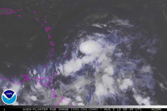
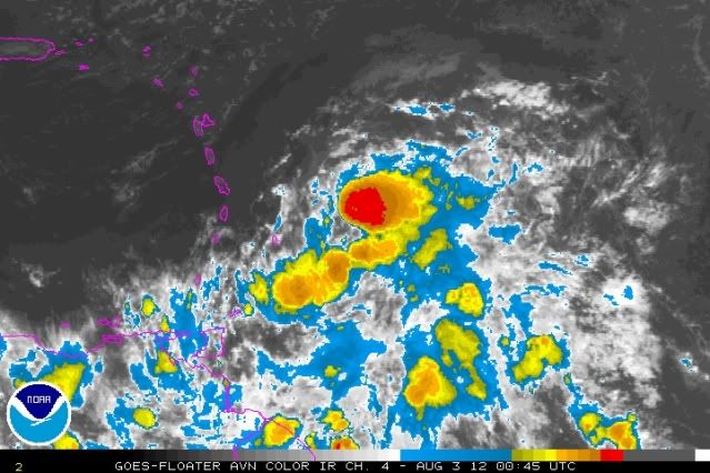
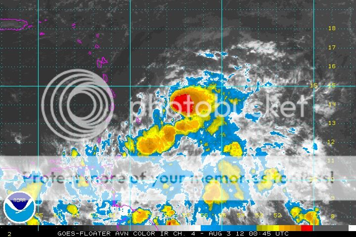
OK it's about time I'll give Ernesto the stamp


LOL, Jevo! Yeah, I think this one is going to be another knock-down drag-out fight between the two. GFS had a super tune-up over the winter and so far it's whumpin' A. Well ok, it got one right. :oops:
0 likes   

User avatar
ROCK
Category 5
Category 5
Posts: 9484
Age: 54
Joined: Tue Aug 17, 2004 7:30 am
Location: Kemah, Texas

Re: ATL: ERNESTO - Models

#1223 Postby ROCK » Thu Aug 02, 2012 8:31 pm

noticed on the 00Z CMC it has shifted south again to almost under the TVCN blend plot.....the 00Z GFS and tonights EURO might clear somethings up...doubt it though... :lol:
0 likes   

floridasun78
Category 5
Category 5
Posts: 3755
Joined: Sun May 17, 2009 10:16 pm
Location: miami fl

Re: ATL: ERNESTO - Models

#1224 Postby floridasun78 » Thu Aug 02, 2012 8:33 pm

SFLcane wrote:00z plots...

Image

yes look like more shift to left
0 likes   

User avatar
gatorcane
S2K Supporter
S2K Supporter
Posts: 23691
Age: 47
Joined: Sun Mar 13, 2005 3:54 pm
Location: Boca Raton, FL

#1225 Postby gatorcane » Thu Aug 02, 2012 8:34 pm

12Z FIM model at 144 hours has a deep system in the Western Caribbean. It goes on to send the system into the BOC and Mexico:

Image
0 likes   

User avatar
Hurricane Alexis
Category 2
Category 2
Posts: 683
Age: 29
Joined: Thu Jun 14, 2012 7:59 pm
Location: Miami,Florida

Re: ATL: ERNESTO - Models

#1226 Postby Hurricane Alexis » Thu Aug 02, 2012 8:37 pm

ronjon wrote:18z NOGAPS - headed for central La. LOL, it also develops our Bahamas wave into a major storm - gotta love the navy model.

https://www.fnmoc.navy.mil/wxmap_cgi/cgi-bin/wxmap_loop.cgi?&area=ngp_troplant&prod=z85&dtg=2012080218&set=Tropical


I find the NOGAPS entertaining.
0 likes   
Personal Forecast Disclaimer:
The posts in this forum are NOT official forecast and should not be used as such. They are just the opinion of the poster and may or may not be backed by sound meteorological data. They are NOT endorsed by any professional institution or storm2k.org. For official information, please refer to the NHC and NWS products.

User avatar
LSU2001
S2K Supporter
S2K Supporter
Posts: 1711
Age: 57
Joined: Sat Sep 11, 2004 11:01 pm
Location: Cut Off, Louisiana

Re: ATL: ERNESTO - Tropical Storm

#1227 Postby LSU2001 » Thu Aug 02, 2012 8:39 pm

I think ole Ernie is starting to get that look. You know the one where it looks like it could really take off at any time. :lol: Now he could die down again in a few hours but I really think he continues to consolidate and when conditions improve a bit it will get real interesting real fast.
Tim

Image


Personal Forecast Disclaimer:
The posts in this forum are NOT official forecast and should not be used as such. They are just the opinion of the poster and may or may not be backed by sound meteorological data. They are NOT endorsed by any professional institution or storm2k.org. For official information, please refer to the NHC and NWS products.
Follow us on
Twitter
0 likes   
Personal Forecast Disclaimer:
The posts in this forum are NOT official forecast and should not be used as such. They are NOT endorsed by any professional institution or storm2k.org. For official information, please refer to the NHC and NWS products.

floridasun78
Category 5
Category 5
Posts: 3755
Joined: Sun May 17, 2009 10:16 pm
Location: miami fl

#1228 Postby floridasun78 » Thu Aug 02, 2012 8:44 pm

0 likes   

User avatar
Hurricane Alexis
Category 2
Category 2
Posts: 683
Age: 29
Joined: Thu Jun 14, 2012 7:59 pm
Location: Miami,Florida

Re:

#1229 Postby Hurricane Alexis » Thu Aug 02, 2012 8:46 pm

floridasun78 wrote:http://raleighwx.americanwx.com/models/atcf/12zatcflateinvest1.gif and here is http://raleighwx.americanwx.com/models/ ... t1best.gif their more stift to left


And in the long run they forecast a more northward shift.
0 likes   
Personal Forecast Disclaimer:
The posts in this forum are NOT official forecast and should not be used as such. They are just the opinion of the poster and may or may not be backed by sound meteorological data. They are NOT endorsed by any professional institution or storm2k.org. For official information, please refer to the NHC and NWS products.

ozonepete
Professional-Met
Professional-Met
Posts: 4743
Joined: Mon Sep 07, 2009 3:23 pm
Location: From Ozone Park, NYC / Now in Brooklyn, NY

Re: ATL: ERNESTO - Tropical Storm

#1230 Postby ozonepete » Thu Aug 02, 2012 8:46 pm

Wow, there is the potential here for really impressive rainfall over the central islands. Take care, guys.
0 likes   

hurricanes1234
Category 5
Category 5
Posts: 2907
Joined: Sat Jul 28, 2012 6:19 pm
Location: Trinidad and Tobago

Re: ATL: ERNESTO - Tropical Storm

#1231 Postby hurricanes1234 » Thu Aug 02, 2012 8:48 pm

At this point, I would really hope that the countries under TS warnings, particularly Barbados, are well-prepared. If not, well, you should start doing so by stocking up on goods (water, oil, batteries, canned foods, matches, candles, etc.), boarding your homes with durable, waterproof wood and by bringing in all plants and pets. You should also try your best to stay as calm as possible.
0 likes   
PLEASE NOTE: With the exception of information from weather agencies that I may copy and paste here, my posts will NEVER be official, since I am NOT a meteorologist. They are solely my amateur opinion, and may or may not be accurate. Therefore, please DO NOT use them as official details, particularly when making important decisions. Thank you.

floridasun78
Category 5
Category 5
Posts: 3755
Joined: Sun May 17, 2009 10:16 pm
Location: miami fl

Re: Re:

#1232 Postby floridasun78 » Thu Aug 02, 2012 8:49 pm

Hurricane Alexis wrote:
floridasun78 wrote:http://raleighwx.americanwx.com/models/atcf/12zatcflateinvest1.gif and here is http://raleighwx.americanwx.com/models/ ... t1best.gif their more stift to left


And in the long run they forecast a more northward shift.

more toward western tip cuba
0 likes   

floridasun78
Category 5
Category 5
Posts: 3755
Joined: Sun May 17, 2009 10:16 pm
Location: miami fl

Re: ATL: ERNESTO - Tropical Storm

#1233 Postby floridasun78 » Thu Aug 02, 2012 8:59 pm

any reports from islands?
0 likes   

User avatar
SouthDadeFish
Professional-Met
Professional-Met
Posts: 2835
Joined: Thu Sep 23, 2010 2:54 pm
Location: Miami, FL
Contact:

#1234 Postby SouthDadeFish » Thu Aug 02, 2012 9:01 pm

Not quite over the center yet:

Image
0 likes   

floridasun78
Category 5
Category 5
Posts: 3755
Joined: Sun May 17, 2009 10:16 pm
Location: miami fl

#1235 Postby floridasun78 » Thu Aug 02, 2012 9:03 pm

i mean to right not left stift of models
0 likes   

User avatar
cycloneye
Admin
Admin
Posts: 145455
Age: 68
Joined: Thu Oct 10, 2002 10:54 am
Location: San Juan, Puerto Rico

Re: ATL: ERNESTO - Tropical Storm

#1236 Postby cycloneye » Thu Aug 02, 2012 9:05 pm

Barbados radar.

Image

http://www.brohavwx.com/
0 likes   
Visit the Caribbean-Central America Weather Thread where you can find at first post web cams,radars
and observations from Caribbean basin members Click Here

User avatar
sunnyday
Category 5
Category 5
Posts: 1590
Joined: Thu Sep 04, 2003 8:16 pm

Re: ATL: ERNESTO - Models

#1237 Postby sunnyday » Thu Aug 02, 2012 9:05 pm

I hope everyone in its path is safe. Local mets and newspapers say no threat to Fl. Is it a bit early to say for sure? 8-) 8-)
0 likes   

User avatar
SeminoleWind
Category 1
Category 1
Posts: 359
Age: 50
Joined: Wed Jun 02, 2010 8:37 pm
Location: Lake County Florida

#1238 Postby SeminoleWind » Thu Aug 02, 2012 9:06 pm

wouldnt be surprised to see more of them bend up toward Cuba later, JMO
0 likes   
This post is NOT an official forecast and should not be used as such. It is just the opinion of the poster and may or may not be backed by sound meteorological data. It is NOT endorsed by any professional institution including storm2k.org For Official Information please refer to the NHC and NWS products.

floridasun78
Category 5
Category 5
Posts: 3755
Joined: Sun May 17, 2009 10:16 pm
Location: miami fl

Re: ATL: ERNESTO - Models

#1239 Postby floridasun78 » Thu Aug 02, 2012 9:06 pm

sunnyday wrote:I hope everyone in its path is safe. Local mets and newspapers say no threat to Fl. Is it a bit early to say for sure? 8-) 8-)

new run models are more to right let see cone at 11pm
0 likes   

User avatar
ROCK
Category 5
Category 5
Posts: 9484
Age: 54
Joined: Tue Aug 17, 2004 7:30 am
Location: Kemah, Texas

Re:

#1240 Postby ROCK » Thu Aug 02, 2012 9:09 pm

SeminoleWind wrote:wouldnt be surprised to see more of them bend up toward Cuba later, JMO


all depends on the ridge and placement. Too far out right now to take any stock after 5 days....
0 likes   


Return to “2012”

Who is online

Users browsing this forum: No registered users and 5 guests