ATL: ERNESTO - Post-Tropical

Moderator: S2k Moderators

Message
Author
Florida1118

Re: ATL: ERNESTO - Tropical Storm

#1301 Postby Florida1118 » Thu Aug 02, 2012 11:34 pm

bwjnj wrote:just wondering what is everyone's odds of this hitting south texas, i'm on vacation from work and wondering if they may call me back

We can't possibly know this far out. You must just bear with us and watch him :) Welcome to S2k.
0 likes   

User avatar
boca
Category 5
Category 5
Posts: 6367
Age: 60
Joined: Mon Dec 15, 2003 8:49 am
Location: Boca Raton,FL

Re: ATL: ERNESTO - Models

#1302 Postby boca » Thu Aug 02, 2012 11:35 pm

Weatherfreak000 what if the weakness occurs along the Northern GOM thats means you will be under the gun but hopefully the southern plains high will keep it south of you as well as the US all together
0 likes   

bwjnj
Tropical Wave
Tropical Wave
Posts: 6
Age: 50
Joined: Thu Sep 01, 2011 12:43 pm
Location: Rio Grande Valley (Deep S. Tex)

Re: ATL: ERNESTO - Tropical Storm

#1303 Postby bwjnj » Thu Aug 02, 2012 11:36 pm

looks like it is starting to ramp up around the center from what i can see on the most current sat images
0 likes   

JamesCaneTracker
Tropical Storm
Tropical Storm
Posts: 207
Joined: Fri Jun 22, 2012 1:33 pm
Location: Portland, Maine

Re: ATL: ERNESTO - Tropical Storm

#1304 Postby JamesCaneTracker » Thu Aug 02, 2012 11:38 pm

bwjnj wrote:looks like it is starting to ramp up around the center from what i can see on the most current sat images


Well on Radar you can see a ring of convection starting to organize just with in the past half hour or so.
0 likes   

JamesCaneTracker
Tropical Storm
Tropical Storm
Posts: 207
Joined: Fri Jun 22, 2012 1:33 pm
Location: Portland, Maine

Re: ATL: ERNESTO - Recon

#1305 Postby JamesCaneTracker » Thu Aug 02, 2012 11:38 pm

000
URNT15 KNHC 030434
AF302 0205A ERNESTO HDOB 03 20120803
042600 1642N 06329W 4101 07399 0391 -145 -155 054009 010 002 001 00
042630 1641N 06327W 4098 07403 0391 -150 -161 049011 011 003 000 00
042700 1639N 06325W 4101 07400 0391 -145 -165 049010 011 004 001 00
042730 1637N 06323W 4099 07403 0392 -145 -170 051010 011 002 001 00
042800 1636N 06321W 4098 07404 0391 -148 -173 055012 013 006 000 00
042830 1634N 06319W 4099 07400 0390 -150 -176 052013 014 006 000 00
042900 1632N 06317W 4097 07404 0389 -150 -179 044014 014 003 001 00
042930 1631N 06316W 4101 07393 0388 -150 -181 049014 015 006 000 00
043000 1629N 06314W 4098 07399 0387 -150 -183 047015 015 004 000 00
043030 1628N 06312W 4098 07400 0388 -149 -185 044014 015 003 000 00
043100 1626N 06310W 4098 07398 0387 -149 -187 044014 014 001 001 00
043130 1624N 06308W 4099 07398 0388 -150 -188 040014 014 000 001 00
043200 1623N 06306W 4097 07401 0387 -147 -189 038013 014 001 000 00
043230 1621N 06304W 4098 07398 0387 -148 -190 041014 015 003 000 00
043300 1619N 06302W 4099 07395 0386 -150 -192 041016 016 003 000 00
043330 1618N 06300W 4097 07400 0386 -149 -192 037016 016 003 000 00
043400 1616N 06258W 4101 07394 0386 -145 -193 036015 016 003 000 00
043430 1614N 06256W 4097 07402 0388 -145 -194 039014 014 003 000 00
043500 1613N 06254W 4098 07398 0387 -145 -195 044013 014 002 000 00
043530 1611N 06252W 4099 07399 0388 -143 -196 052012 012 005 000 00
$$
;
0 likes   

Weatherfreak000

Re: ATL: ERNESTO - Models

#1306 Postby Weatherfreak000 » Thu Aug 02, 2012 11:40 pm

boca wrote:Weatherfreak000 what if the weakness occurs along the Northern GOM thats means you will be under the gun but hopefully the southern plains high will keep it south of you as well as the US all together


Weakness could extend anywhere from Central LA to probably FL Panhandle. I suppose the Peninsula still can see Ernesto, but IMO it would depend solely on whether Ernesto will RI, RI potentials are about 1/4. 25% isn't exactly ideal odds, but it's still a possibility.

Can't really give forecast ideas yet, way too far away.
0 likes   

SunnyThoughts
Category 5
Category 5
Posts: 2263
Joined: Wed Jul 09, 2003 12:42 pm
Location: Pensacola, Florida

Re: ATL: ERNESTO - Tropical Storm

#1307 Postby SunnyThoughts » Thu Aug 02, 2012 11:41 pm

JamesCaneTracker wrote:
bwjnj wrote:looks like it is starting to ramp up around the center from what i can see on the most current sat images


Well on Radar you can see a ring of convection starting to organize just with in the past half hour or so.


Yeah, recon is headed out at a most opportune time. We will know if the winds are coming up in the not too distant future.
0 likes   

User avatar
wkwally
Category 1
Category 1
Posts: 279
Joined: Sun Jun 27, 2010 9:18 pm
Location: Humble, Texas

Re: ATL: ERNESTO - Tropical Storm

#1308 Postby wkwally » Thu Aug 02, 2012 11:44 pm

bwjnj wrote:just wondering what is everyone's odds of this hitting south texas, i'm on vacation from work and wondering if they may call me back

Keep an eye out and just be ready. From what I am seeing if it does come here it would be around the 11th. I am going over my plans and also we are preping our high profile clients just to be a little on the boy scout side. if it misses than we were ready if it hits we will be ready. right now it is too far out to know for sure where it will make landfall but seeing the models better be ready than not
0 likes   

User avatar
Rgv20
S2K Supporter
S2K Supporter
Posts: 2466
Age: 39
Joined: Wed Jan 05, 2011 5:42 pm
Location: Edinburg/McAllen Tx

#1309 Postby Rgv20 » Thu Aug 02, 2012 11:46 pm

Well it looks like TS Ernesto is going to feel the weakness in the NW Caribbean, the question is for how long?? As the GFS and ECMWF restrengthen the Ridge in the Southern Plains by day 7 and beyond. By next Saturday Evening the 0zGFS has Ernesto making landfall in the Central Mexican Coast.

0zGFS forecast for Friday Morning
Image

0zGFS forecast for Friday Evening.
Image
0 likes   
The following post is NOT an official forecast and should not be used as such. It is just the opinion of the poster and may or may not be backed by sound meteorological data. It is NOT endorsed by any professional institution including storm2k.org For Official Information please refer to the NHC and NWS products.

JamesCaneTracker
Tropical Storm
Tropical Storm
Posts: 207
Joined: Fri Jun 22, 2012 1:33 pm
Location: Portland, Maine

#1310 Postby JamesCaneTracker » Thu Aug 02, 2012 11:48 pm

000
URNT15 KNHC 030444
AF302 0205A ERNESTO HDOB 04 20120803
043600 1609N 06250W 4098 07400 0388 -145 -196 056013 013 005 000 00
043630 1608N 06248W 4097 07402 0387 -144 -196 048012 013 005 000 00
043700 1606N 06246W 4099 07395 0387 -144 -197 051011 012 005 001 00
043730 1604N 06244W 4098 07400 0388 -145 -197 055012 013 006 000 00
043800 1603N 06242W 4099 07396 0387 -145 -198 051012 013 007 000 00
043830 1601N 06240W 4098 07400 0386 -145 -198 049012 012 005 000 00
043900 1559N 06239W 4100 07395 0386 -143 -198 046011 012 006 000 00
043930 1558N 06237W 4097 07402 0386 -142 -198 045011 012 001 000 00
044000 1556N 06235W 4098 07400 0387 -141 -199 045011 011 000 001 00
044030 1554N 06233W 4101 07395 0388 -142 -199 048013 013 000 001 00
044100 1553N 06231W 4098 07399 0387 -143 -199 045013 014 000 001 00
044130 1551N 06229W 4099 07396 0387 -144 -199 051014 014 000 000 00
044200 1550N 06227W 4096 07401 0386 -140 -200 040013 014 000 001 00
044230 1548N 06225W 4101 07390 0384 -140 -200 038013 014 000 000 00
044300 1546N 06223W 4097 07396 0383 -140 -200 041013 014 000 000 00
044330 1545N 06221W 4101 07391 0384 -141 -200 043014 015 000 000 00
044400 1543N 06219W 4095 07402 0385 -140 -200 040012 013 001 001 00
044430 1541N 06217W 4099 07396 0386 -141 -200 043013 013 008 000 00
044500 1540N 06215W 4098 07401 0388 -140 -200 044013 013 009 000 00
044530 1538N 06213W 4101 07395 0387 -144 -201 060012 013 009 000 00
$$
;

If some one could post the Google Earth images that would be great. I'm not setup tonight to be able to do that.
0 likes   

MiamiensisWx

Re: ATL: ERNESTO - Tropical Storm

#1311 Postby MiamiensisWx » Thu Aug 02, 2012 11:55 pm

Personal Forecast Disclaimer:
The posts in this forum are NOT official forecast and should not be used as such. They are just the opinion of the poster and may or may not be backed by sound meteorological data. They are NOT endorsed by any professional institution or storm2k.org. For official information, please refer to the NHC and NWS products.


The 12Z GFS errs in its initialization of the upper-level environment...it shows westerly winds of 15 mph impinging upon Ernesto, whereas the CIMSS satellite analysis at 250 mb shows a well-defined anticyclone with strong divergence in and around the center. I think that the GFS fails to take into account recent trends after 00Z and also is too slow...it shows the center passing south of Barbados in six hours even as radar indicates the center is already NNW of Barbados as of 0400Z. Clearly, the fact that it weakens Ernesto is not to be discarded.

GFS solution at 0600Z:

http://img600.imageshack.us/img600/9844/gfsatlantic00610mwndpre.gif

GFS initialization at 250 mb:

http://img442.imageshack.us/img442/8382/gfsatlantic000250wndht0.gif

CIMSS analysis as of 0000Z:

http://img232.imageshack.us/img232/9475/wg8wvir10000zaug3.gif

Later satellite-derived vectors at 0300Z:

http://img441.imageshack.us/img441/2664/wg8wvir0300zaug3.gif
Last edited by MiamiensisWx on Fri Aug 03, 2012 12:05 am, edited 1 time in total.
0 likes   

User avatar
Gustywind
Category 5
Category 5
Posts: 12334
Joined: Mon Sep 03, 2007 7:29 am
Location: Baie-Mahault, GUADELOUPE

#1312 Postby Gustywind » Thu Aug 02, 2012 11:56 pm

02/2345 UTC 13.7N 57.0W T2.0/2.0 ERNESTO
:rarrow: http://www.ssd.noaa.gov/PS/TROP/tdpositions.html
0 likes   

Stormlover2012
Category 1
Category 1
Posts: 262
Joined: Sat Jun 23, 2012 11:03 am

Re: ATL: ERNESTO - Models

#1313 Postby Stormlover2012 » Thu Aug 02, 2012 11:57 pm

still have a long way to go fellas, this run didnt intialize that well
0 likes   

JamesCaneTracker
Tropical Storm
Tropical Storm
Posts: 207
Joined: Fri Jun 22, 2012 1:33 pm
Location: Portland, Maine

#1314 Postby JamesCaneTracker » Thu Aug 02, 2012 11:57 pm

000
URNT15 KNHC 030454
AF302 0205A ERNESTO HDOB 05 20120803
044600 1536N 06211W 4098 07401 0388 -144 -201 060012 012 001 000 00
044630 1535N 06209W 4095 07403 0387 -145 -201 064012 012 006 000 00
044700 1534N 06207W 4099 07396 0388 -141 -202 057012 012 009 000 00
044730 1533N 06205W 4099 07399 0387 -140 -202 045011 011 010 000 00
044800 1532N 06202W 4099 07397 0388 -142 -203 053012 012 011 001 00
044830 1531N 06200W 4095 07406 0390 -142 -203 046011 012 011 000 00
044900 1529N 06158W 4102 07395 0390 -145 -204 054014 015 007 000 00
044930 1528N 06156W 4097 07405 0389 -145 -204 041012 012 008 000 00
045000 1527N 06153W 4099 07397 0388 -141 -205 035012 012 012 000 00
045030 1526N 06151W 4098 07401 0388 -140 -205 037012 013 012 000 00
045100 1525N 06149W 4099 07400 0389 -140 -205 042014 014 011 001 00
045130 1524N 06146W 4098 07399 0388 -140 -206 046014 015 010 000 00
045200 1523N 06144W 4098 07395 0385 -140 -206 050015 015 008 000 00
045230 1521N 06142W 4098 07400 0386 -139 -207 036012 013 005 000 00
045300 1520N 06140W 4097 07400 0386 -137 -207 032012 014 001 000 00
045330 1519N 06137W 4100 07394 0385 -142 -207 052014 015 003 000 00
045400 1518N 06135W 4094 07407 0387 -138 -207 037011 014 004 000 00
045430 1517N 06133W 4168 07284 0390 -131 -207 053014 017 006 000 00
045500 1515N 06131W 4368 06931 0374 -111 -208 059013 014 003 000 00
045530 1514N 06128W 4551 06618 0357 -099 -207 081012 017 001 000 00
$$
;

The are now going down to Operational Flight Level!
0 likes   

JamesCaneTracker
Tropical Storm
Tropical Storm
Posts: 207
Joined: Fri Jun 22, 2012 1:33 pm
Location: Portland, Maine

#1315 Postby JamesCaneTracker » Fri Aug 03, 2012 12:00 am

I believe Recon will be doing a NorthWest to SouthEast pass to start this mission!
0 likes   

User avatar
ROCK
Category 5
Category 5
Posts: 9484
Age: 54
Joined: Tue Aug 17, 2004 7:30 am
Location: Kemah, Texas

Re: ATL: ERNESTO - Models

#1316 Postby ROCK » Fri Aug 03, 2012 12:00 am

00Z NOGAPS finally in line with all the rest of the reliable globals....

https://www.fnmoc.navy.mil/wxmap_cgi/cg ... t=Tropical
0 likes   

floridasun78
Category 5
Category 5
Posts: 3755
Joined: Sun May 17, 2009 10:16 pm
Location: miami fl

Re: ATL: ERNESTO - Recon

#1317 Postby floridasun78 » Fri Aug 03, 2012 12:04 am

Image

Uploaded with ImageShack.us
0 likes   

User avatar
Kingarabian
S2K Supporter
S2K Supporter
Posts: 16006
Joined: Sat Aug 08, 2009 3:06 am
Location: Honolulu, Hawaii

Re: ATL: ERNESTO - Models

#1318 Postby Kingarabian » Fri Aug 03, 2012 12:05 am

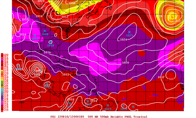
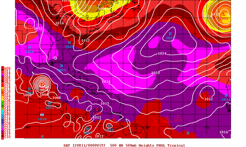
ROCK wrote:00Z NOGAPS finally in line with all the rest of the reliable globals....

https://www.fnmoc.navy.mil/wxmap_cgi/cg ... t=Tropical

For now.
0 likes   
RIP Kobe Bryant

JamesCaneTracker
Tropical Storm
Tropical Storm
Posts: 207
Joined: Fri Jun 22, 2012 1:33 pm
Location: Portland, Maine

#1319 Postby JamesCaneTracker » Fri Aug 03, 2012 12:08 am

000
URNT15 KNHC 030504
AF302 0205A ERNESTO HDOB 06 20120803
045600 1513N 06126W 4724 06321 0333 -080 -204 086022 028 012 000 00
045630 1512N 06124W 4898 06043 0317 -072 -199 098025 027 018 000 00
045700 1511N 06122W 5106 05724 0306 -068 -193 086013 016 017 000 00
045730 1510N 06120W 5324 05399 0290 -042 -187 047007 008 014 000 00
045800 1509N 06118W 5553 05063 0113 -009 -180 070007 010 014 000 00
045830 1508N 06116W 5760 04769 0109 +011 -171 081016 017 011 000 00
045900 1507N 06114W 5968 04486 0121 +025 -161 070018 022 013 000 00
045930 1506N 06112W 6188 04198 0148 +031 -148 069025 026 013 000 00
050000 1505N 06110W 6420 03899 0158 +044 -136 068029 031 014 000 00
050030 1504N 06108W 6654 03609 0160 +059 -121 069030 030 012 000 00
050100 1503N 06107W 6903 03296 0152 +080 -106 065031 032 010 000 00
050130 1502N 06105W 7158 02996 0151 +098 -091 066034 036 013 000 00
050200 1501N 06103W 7403 02711 0149 +116 -073 069036 036 012 000 00
050230 1500N 06101W 7652 02434 0146 +133 -055 068035 036 012 000 00
050300 1500N 06100W 7911 02151 0148 +146 -039 070036 037 012 000 00
050330 1459N 06058W 8164 01882 0152 +155 -021 073036 038 015 000 00
050400 1458N 06057W 8391 01642 0150 +160 -003 073034 035 012 000 00
050430 1457N 06055W 8423 01603 0143 +161 +012 075035 036 016 000 00
050500 1457N 06054W 8410 01617 0145 +155 +024 071033 034 017 000 00
050530 1456N 06053W 8416 01611 0143 +155 +034 068034 036 016 000 00
$$
;
0 likes   

User avatar
ROCK
Category 5
Category 5
Posts: 9484
Age: 54
Joined: Tue Aug 17, 2004 7:30 am
Location: Kemah, Texas

Re: ATL: ERNESTO - Models

#1320 Postby ROCK » Fri Aug 03, 2012 12:08 am

Well considering it was the furthest right outlier this is quite a change....I would say even a dramatic change....
0 likes   


Return to “2012”

Who is online

Users browsing this forum: No registered users and 3 guests