ATL: ERNESTO - Post-Tropical
Moderator: S2k Moderators
-
floridasun78
- Category 5

- Posts: 3755
- Joined: Sun May 17, 2009 10:16 pm
- Location: miami fl
-
JamesCaneTracker
- Tropical Storm

- Posts: 207
- Joined: Fri Jun 22, 2012 1:33 pm
- Location: Portland, Maine
Re: ATL: ERNESTO - Recon
I prob. won't be here for the whole mission. After the first pass I may go to bed.
0 likes
-
JamesCaneTracker
- Tropical Storm
- Posts: 207
- Joined: Fri Jun 22, 2012 1:33 pm
- Location: Portland, Maine
000
URNT15 KNHC 030515
AF302 0205A ERNESTO HDOB 07 20120803
050600 1455N 06051W 8415 01609 0136 +162 +042 068035 036 017 000 00
050630 1454N 06050W 8429 01597 0132 +169 +048 067035 036 018 000 00
050700 1454N 06048W 8406 01614 0126 +171 +054 067036 037 017 000 00
050730 1453N 06047W 8417 01606 0128 +169 +060 065035 036 018 000 00
050800 1453N 06047W 8417 01606 0129 +162 +067 066032 034 018 001 00
050830 1452N 06044W 8425 01601 0137 +161 +073 068034 037 018 001 00
050900 1451N 06043W 8396 01624 0127 +167 +076 074039 040 018 000 00
050930 1450N 06042W 8417 01601 0124 +169 +078 074040 041 014 001 00
051000 1450N 06041W 8414 01604 0125 +165 +081 073041 041 016 000 00
051030 1449N 06039W 8415 01603 0126 +164 +084 073040 040 017 000 00
051100 1448N 06038W 8417 01602 0127 +161 +086 072039 039 018 000 00
051130 1447N 06037W 8414 01604 0127 +162 +088 073037 038 020 000 00
051200 1446N 06036W 8413 01604 0125 +162 +090 074037 038 018 001 00
051230 1445N 06035W 8420 01596 0124 +164 +091 074039 040 017 000 00
051300 1444N 06034W 8416 01601 0129 +155 +093 075042 043 018 000 00
051330 1443N 06033W 8415 01602 0129 +155 +094 072041 043 019 000 00
051400 1442N 06032W 8418 01598 0127 +159 +094 072040 041 020 001 00
051430 1441N 06031W 8417 01597 0123 +162 +093 072038 038 020 000 00
051500 1440N 06030W 8419 01597 0124 +163 +093 070036 037 017 000 00
051530 1439N 06029W 8412 01603 0122 +163 +094 069039 039 018 000 00
$$
;
0 likes

I've been watching the Barbados radar for a few hours and I'm having a difficult time seeing if the center is closed or not
0 likes
The above post is not official and should not be used as such. It is the opinion of the poster and may or may not be backed by sound meteorological data. It is not endorsed by any professional institution or storm2k.org. For official information, please refer to the NHC and NWS products.

-
JamesCaneTracker
- Tropical Storm
- Posts: 207
- Joined: Fri Jun 22, 2012 1:33 pm
- Location: Portland, Maine
Re: ATL: ERNESTO - Tropical Storm
You wouldn't be able to tell on Radar if the center is closed... When they check to see if the center is closed it's based on winds not precip. or cloud cover which is what Radar shows...
0 likes

Ernesto wants to become Ernasty
CrazyC83 wrote:Another possible analog I can think of might be Charley, depending on if a trough can come in.
Since its inception, several analogs come to mind including Hurricane Charley, Dennis, Ernesto, in some ways Gustav (2008), and maybe TS Emily from last year which had a similar date (1 year ago today in a similar position). Its very eerie how close this is turning out like the last Ernesto but the outcome will be very different...maybe doing what the last Ernesto failed to accomplish...take the ultimate trek in the Caribbean and round up through the gap in the Yucatan to enter the GOM. The factors that prevented the last Ernesto and some other similar setup systems is gone for this one...the slow speed and reforming centers that screwed the track.
Zeno8 wrote:What an ugly cone!
Coneheads are worse
cycloneye wrote:Still waiting for discussion. CHeck the advisory thread as soon is posted.
That would be in the top 2 latest discussions I've seen if that was true. The gears are really turning over at the NHC on this one.
MiamiensisWx wrote:*Awesome Discussion on Thu Aug 02, 2012 11:53 pm*
MiamiensisWx, you have just posted the best post I've have seen on S2K this year, that was fantastic! What a turnaround from your other one but not only that, it sounded like it came from a meteorologists' blog that fit together in terms of the concepts highlighted. Well done
JamesCaneTracker wrote:We now have the center CLEARLY visible on the Barbados radar:
http://www.barbadosweather.org/barbados ... -radar.php
The convection is behaving like a organizing TS so it wouldn't surprise me.
0 likes
-
Hurricane Alexis

- Category 2

- Posts: 683
- Age: 29
- Joined: Thu Jun 14, 2012 7:59 pm
- Location: Miami,Florida
Re: ATL: ERNESTO - Models
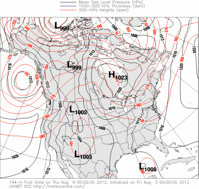
0z CMC has it crossing the yucatan channel and the entering the southern GOM.
http://moe.met.fsu.edu/cgi-bin/cmctc2.c ... =Animation
http://moe.met.fsu.edu/cgi-bin/cmctc2.c ... =Animation
0 likes
Personal Forecast Disclaimer:
The posts in this forum are NOT official forecast and should not be used as such. They are just the opinion of the poster and may or may not be backed by sound meteorological data. They are NOT endorsed by any professional institution or storm2k.org. For official information, please refer to the NHC and NWS products.
The posts in this forum are NOT official forecast and should not be used as such. They are just the opinion of the poster and may or may not be backed by sound meteorological data. They are NOT endorsed by any professional institution or storm2k.org. For official information, please refer to the NHC and NWS products.
-
Rgv20

- S2K Supporter

- Posts: 2466
- Age: 39
- Joined: Wed Jan 05, 2011 5:42 pm
- Location: Edinburg/McAllen Tx
0 likes
The following post is NOT an official forecast and should not be used as such. It is just the opinion of the poster and may or may not be backed by sound meteorological data. It is NOT endorsed by any professional institution including storm2k.org For Official Information please refer to the NHC and NWS products.
-
JamesCaneTracker
- Tropical Storm
- Posts: 207
- Joined: Fri Jun 22, 2012 1:33 pm
- Location: Portland, Maine
-
Weatherfreak000
Re: ATL: ERNESTO - Models
ROCK wrote:Well considering it was the furthest right outlier this is quite a change....I would say even a dramatic change....
I'd say if it goes south of Jamaica we have a general idea where he may go...if it goes North then where? The weakness I observed with GFDL earlier seemed to suggest the weakness should be there, as does the CMC. Recent UKMET run shows weakness in North GOM. What gives? Make anything of that ROCK?
Last edited by Weatherfreak000 on Fri Aug 03, 2012 12:34 am, edited 1 time in total.
0 likes
-
Rgv20
- S2K Supporter
- Posts: 2466
- Age: 39
- Joined: Wed Jan 05, 2011 5:42 pm
- Location: Edinburg/McAllen Tx
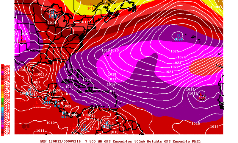
0zGFS Ensemble Means has Ernesto to the South Texas Coast by next Saturday while the operational has Ernesto into the Central Mexican Coast.
0 likes
The following post is NOT an official forecast and should not be used as such. It is just the opinion of the poster and may or may not be backed by sound meteorological data. It is NOT endorsed by any professional institution including storm2k.org For Official Information please refer to the NHC and NWS products.

Re: ATL: ERNESTO - Models
Weatherfreak000 wrote:ROCK wrote:Well considering it was the furthest right outlier this is quite a change....I would say even a dramatic change....
I'd say if it goes south of Jamaica we have a general idea where he may go...if it goes North then where? The weakness I observed with GFDL either seemed to suggest the weakness should be there, as does the CMC. Recent UKMET run shows weakness in North GOM. What gives? Make anything of that ROCK?
IMO, oh I think it will stay south then feel the weakness and make a run at it only to be turned back once in the GOM.....now how fast does the ridge build back in , how far NW does E get and how strong it is IDK.....beyond 5 days its really a toss up.....FL Panhandle to Brownsville...somewhere in between is my guess right now...
0 likes
Re:
[quote="Rgv20"]0zGFS Ensemble Means has Ernesto to the South Texas Coast by next Saturday while the operational has Ernesto into the Central Mexican Coast.
http://i61.photobucket.com/albums/h62/c ... 6.gifquote]
thats a big hole up along the TX coast and to SWLA.....GFS ensembles usually point the way for the next GFS run 06Z....
http://i61.photobucket.com/albums/h62/c ... 6.gifquote]
thats a big hole up along the TX coast and to SWLA.....GFS ensembles usually point the way for the next GFS run 06Z....
0 likes
-
JamesCaneTracker
- Tropical Storm
- Posts: 207
- Joined: Fri Jun 22, 2012 1:33 pm
- Location: Portland, Maine
-
JamesCaneTracker
- Tropical Storm
- Posts: 207
- Joined: Fri Jun 22, 2012 1:33 pm
- Location: Portland, Maine
000
URNT15 KNHC 030544
AF302 0205A ERNESTO HDOB 10 20120803
053600 1349N 05951W 8412 01570 0073 +178 +125 053042 042 024 000 00
053630 1348N 05950W 8420 01555 0068 +175 +127 051040 042 025 001 00
053700 1346N 05949W 8413 01562 0064 +177 +128 046039 040 028 000 00
053730 1345N 05948W 8413 01557 0065 +169 +129 039035 035 028 001 03
053800 1344N 05947W 8416 01553 0065 +167 +128 032033 034 027 003 00
053830 1342N 05946W 8418 01550 0066 +164 +127 028029 030 027 002 03
053900 1341N 05945W 8414 01553 0060 +172 +124 017021 024 025 003 03
053930 1341N 05943W 8418 01547 0055 +175 +123 003015 018 023 003 03
054000 1340N 05941W 8412 01552 0055 +173 +123 338009 012 023 000 00
054030 1340N 05940W 8420 01544 0050 +183 +123 257005 007 016 000 00
054100 1340N 05938W 8416 01547 0051 +181 +123 215009 013 014 001 00
054130 1340N 05936W 8412 01552 0053 +178 +125 195017 019 010 001 00
054200 1339N 05934W 8416 01546 0052 +178 +127 185023 025 007 001 03
054230 1338N 05933W 8418 01548 0053 +181 +129 173023 024 009 001 00
054300 1337N 05932W 8409 01561 0065 +164 +131 175021 022 016 006 03
054330 1336N 05931W 8417 01555 0069 +167 +130 168020 021 017 004 00
054400 1335N 05930W 8416 01559 0068 +174 +128 162021 021 005 002 00
054430 1334N 05929W 8414 01564 0070 +175 +127 167021 021 004 001 00
054500 1333N 05928W 8415 01564 0072 +174 +127 165019 020 001 001 00
054530 1332N 05927W 8413 01567 0073 +175 +128 156021 022 000 000 00
$$
;
Looks like they just went through the center and 1005mb was the lowest pressure.
0 likes
Re: ATL: ERNESTO - Models
I am shocked no one is staying up for the EURO..... 
initialized it at 1010MB though...
http://raleighwx.americanwx.com/models/ ... SLP000.gif
initialized it at 1010MB though...
http://raleighwx.americanwx.com/models/ ... SLP000.gif
0 likes
-
Stormlover2012
- Category 1

- Posts: 262
- Joined: Sat Jun 23, 2012 11:03 am
-
Hurricane Alexis
- Category 2
- Posts: 683
- Age: 29
- Joined: Thu Jun 14, 2012 7:59 pm
- Location: Miami,Florida
Re: ATL: ERNESTO - Tropical Storm
2 am advisory
000
WTNT35 KNHC 030554
TCPAT5
BULLETIN
TROPICAL STORM ERNESTO INTERMEDIATE ADVISORY NUMBER 6A
NWS NATIONAL HURRICANE CENTER MIAMI FL AL052012
200 AM AST FRI AUG 03 2012
...CENTER OF ERNESTO PASSING NORTH OF BARBADOS...EXPECTED TO MOVE
ACROSS THE NORTHERN WINDWARD ISLANDS DURING THE NEXT FEW HOURS...
SUMMARY OF 200 AM AST...0600 UTC...INFORMATION
----------------------------------------------
LOCATION...13.6N 59.7W
ABOUT 35 MI...55 KM NNW OF BARBADOS
ABOUT 90 MI...145 KM E OF ST. LUCIA
MAXIMUM SUSTAINED WINDS...50 MPH...85 KM/H
PRESENT MOVEMENT...W OR 275 DEGREES AT 23 MPH...37 KM/H
MINIMUM CENTRAL PRESSURE...1005 MB...29.68 INCHES
0 likes
Personal Forecast Disclaimer:
The posts in this forum are NOT official forecast and should not be used as such. They are just the opinion of the poster and may or may not be backed by sound meteorological data. They are NOT endorsed by any professional institution or storm2k.org. For official information, please refer to the NHC and NWS products.
The posts in this forum are NOT official forecast and should not be used as such. They are just the opinion of the poster and may or may not be backed by sound meteorological data. They are NOT endorsed by any professional institution or storm2k.org. For official information, please refer to the NHC and NWS products.
Re: ATL: ERNESTO - Models
Stormlover2012 wrote:im up babyy!!! lol yeah seems like this could be a descent run
good I could use the company....
0 likes
Who is online
Users browsing this forum: No registered users and 14 guests