

ATL: ISAAC - Post-Tropical - Discussion
Moderator: S2k Moderators
Re: ATL: ISAAC - Tropical Storm - Discussion
It's almost 'nowcast' time for Anguilla. First bits of rain and heavy, heavy rumbling to the east.
0 likes
-
jlauderdal
- S2K Supporter

- Posts: 7240
- Joined: Wed May 19, 2004 5:46 am
- Location: NE Fort Lauderdale
- Contact:
Re: ATL: ISAAC - Tropical Storm - Discussion
ObsessedMiami wrote:Weird discussion of Issac on NBC6 Miami is morning. Met Ryan Phillips said "there are too many variables to predict what impact Issac will have on Florida yet" but then said "we are in the center of the cone and will be there for some time."
whats weird about that, both statements are absolutely correct....however, since you are in south florida then you really need to beware of factually incorrect statements from our local media, even some of the weather staff...you will hear things in the next few days that will make you go HUH
0 likes
-
Weatherboy1

- Category 5

- Posts: 1190
- Age: 50
- Joined: Mon Jul 05, 2004 1:50 pm
- Location: Jupiter/Sarasota, FL
Very interesting setup this morning to say the least. And definitely watching closely here in South FL! As another poster noted, we're seeing the windshield wiper effect between runs -slightly more east on one, slightly more west on the other. But all in all, FL does appear to be under the gun here. Just a question of whether it's South Fl or the Panhandle at this time. My opinion, as an amateur, as always!
0 likes
-
Gustywind

- Category 5
- Posts: 12334
- Joined: Mon Sep 03, 2007 7:29 am
- Location: Baie-Mahault, GUADELOUPE
Re: ATL: ISAAC - Tropical Storm - Discussion
Jimsot wrote:It's almost 'nowcast' time for Anguilla. First bits of rain and heavy, heavy rumbling to the east.
Thanks for your report. Be safe and dry Jimsot
0 likes
-
Dean4Storms
- S2K Supporter
- Posts: 6358
- Age: 62
- Joined: Sun Aug 31, 2003 1:01 pm
- Location: Miramar Bch. FL
-
jlauderdal
- S2K Supporter
- Posts: 7240
- Joined: Wed May 19, 2004 5:46 am
- Location: NE Fort Lauderdale
- Contact:
Re:
JPmia wrote:I will be glued to Max Mayfield on Channel 10.. We haven't seen this much model consistency since Wilma.. for a south Florida storm at least
yep, channel 10 has the best with mayfield and trent aric, channel 4 is second, channel 5 is third and then the hype machine is last
0 likes
-
jusforsean

- Category 1

- Posts: 395
- Joined: Wed Nov 09, 2005 8:22 am
- Location: South Florida
Re: ATL: ISAAC - Tropical Storm - Discussion
Yes, Erie Wilma like reminder we were the target. Either way looks like we will be on the dirty side of the storm. 
0 likes


-
DESTRUCTION5

- Category 5
- Posts: 4430
- Age: 44
- Joined: Wed Sep 03, 2003 11:25 am
- Location: Stuart, FL
Re: ATL: ISAAC - Tropical Storm - Discussion
The official forecast track for Isaac this morning looks almost identical to Irene's first forecast track last year.
http://www.nhc.noaa.gov/archive/2011/gr ... p_5W.shtml
http://www.nhc.noaa.gov/archive/2011/gr ... p_5W.shtml
0 likes

Re: ATL: ISAAC - Tropical Storm - Discussion
VIS showing two large hot-towers
Can see the one at 16.1N 56.8W, 0945Z rotate CCW.
http://www.ssd.noaa.gov/PS/TROP/floater ... -long.html
The other is seen clearly at 15.4N 58.5W, 1045Z
NexSat is still showing rain-rate maxed out at 1045Z
http://www.nrlmry.navy.mil/nexdat/CONUS ... bean.0.jpg
Can see the one at 16.1N 56.8W, 0945Z rotate CCW.
http://www.ssd.noaa.gov/PS/TROP/floater ... -long.html
The other is seen clearly at 15.4N 58.5W, 1045Z
NexSat is still showing rain-rate maxed out at 1045Z
http://www.nrlmry.navy.mil/nexdat/CONUS ... bean.0.jpg
0 likes
-
tolakram
- Admin

- Posts: 20176
- Age: 62
- Joined: Sun Aug 27, 2006 8:23 pm
- Location: Florence, KY (name is Mark)
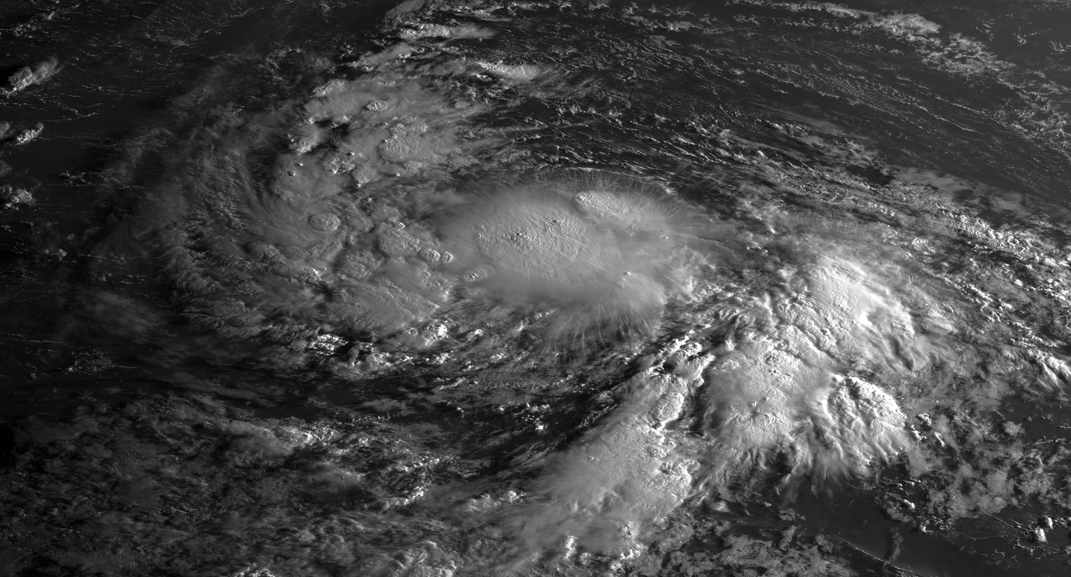
Re: ATL: ISAAC - Tropical Storm - Discussion
Morning HiRes Visible
0 likes
M a r k
- - - - -
Join us in chat: Storm2K Chatroom Invite. Android and IOS apps also available.
The posts in this forum are NOT official forecasts and should not be used as such. Posts are NOT endorsed by any professional institution or STORM2K.org. For official information and forecasts, please refer to NHC and NWS products.
-
Gustywind
- Category 5
- Posts: 12334
- Joined: Mon Sep 03, 2007 7:29 am
- Location: Baie-Mahault, GUADELOUPE
Hurricane Season
Tropical Storm Isaac heading toward Caribbean
Stu Ostro, Senior Meteorologist, The Weather Channel
Aug 22, 2012 2:59 am ET
 http://www.weather.com/newscenter/tropical/
TROPICAL STORM ISAAC
- Isaac is starting to get a little better organized, but latest aircraft reconnaissance which has been investigating has not found signs of significant/rapid strengthening.
- The first land area to be affected is the Lesser Antilles today (Wednesday) into tomorrow with bands of heavy rain and very gusty winds.
- Next, the system will head across the northern Caribbean late this week and this weekend, near the Greater Antilles (Puerto Rico, Hispaniola, Jamaica, Cuba). Its intensity during and immediately after this trek will be determined in part by the extent to which the core of the storm spends tracks over land; regardless of how much the system cranks up wind-wise, it will be capable of producing heavy rainfall and life-threatening flash flooding and mudslides.
- In the longer range, i.e. next week, critical track and timing uncertainties increase (along with the inherent intensity uncertainty which is notorious with tropical cyclones). In fact, our two main "global" models in their latest runs diverge wildly in their track forecasts, the GFS model racing the storm into South Florida on Monday, and the ECMWF ("European") keeping the ridge of high pressure to the north stronger, blocking the storm and swerving it west to just north of the Yucatan during the first part of the week and then pulling it up to Louisiana late in the week. The last time there was such a Clash of the Titans, with Debby, it was an Epic FAIL for the ECMWF; we'll see which model is better this time.
- Regardless, there's a high probability of the United States being affected, so residents and visitors in the Southeast, Gulf Coast, and East Coast as well as the Yucatan should be vigilant and stay abreast of the latest forecast trends.
Tropical Storm Isaac heading toward Caribbean
Stu Ostro, Senior Meteorologist, The Weather Channel
Aug 22, 2012 2:59 am ET
TROPICAL STORM ISAAC
- Isaac is starting to get a little better organized, but latest aircraft reconnaissance which has been investigating has not found signs of significant/rapid strengthening.
- The first land area to be affected is the Lesser Antilles today (Wednesday) into tomorrow with bands of heavy rain and very gusty winds.
- Next, the system will head across the northern Caribbean late this week and this weekend, near the Greater Antilles (Puerto Rico, Hispaniola, Jamaica, Cuba). Its intensity during and immediately after this trek will be determined in part by the extent to which the core of the storm spends tracks over land; regardless of how much the system cranks up wind-wise, it will be capable of producing heavy rainfall and life-threatening flash flooding and mudslides.
- In the longer range, i.e. next week, critical track and timing uncertainties increase (along with the inherent intensity uncertainty which is notorious with tropical cyclones). In fact, our two main "global" models in their latest runs diverge wildly in their track forecasts, the GFS model racing the storm into South Florida on Monday, and the ECMWF ("European") keeping the ridge of high pressure to the north stronger, blocking the storm and swerving it west to just north of the Yucatan during the first part of the week and then pulling it up to Louisiana late in the week. The last time there was such a Clash of the Titans, with Debby, it was an Epic FAIL for the ECMWF; we'll see which model is better this time.
- Regardless, there's a high probability of the United States being affected, so residents and visitors in the Southeast, Gulf Coast, and East Coast as well as the Yucatan should be vigilant and stay abreast of the latest forecast trends.
0 likes
-
cycloneye

- Admin
- Posts: 149202
- Age: 69
- Joined: Thu Oct 10, 2002 10:54 am
- Location: San Juan, Puerto Rico
Re: ATL: ISAAC - Tropical Storm - Discussion
ISAAC NEARING THE LESSER ANTILLES...HURRICANE WATCH ISSUED FOR
THE BRITISH VIRGIN ISLANDS...
SUMMARY OF 800 AM AST...1200 UTC...INFORMATION
----------------------------------------------
LOCATION...15.7N 58.4W
ABOUT 210 MI...340 KM E OF GUADELOUPE
MAXIMUM SUSTAINED WINDS...45 MPH...75 KM/H
PRESENT MOVEMENT...W OR 270 DEGREES AT 19 MPH...31 KM/H
MINIMUM CENTRAL PRESSURE...1004 MB...29.65 INCHES
0 likes
Visit the Caribbean-Central America Weather Thread where you can find at first post web cams,radars
and observations from Caribbean basin members Click Here
and observations from Caribbean basin members Click Here
Re: ATL: ISAAC - Tropical Storm - Discussion
FC1 15.8N/58.1W actual 15.7/58.4 not to shabby on the part of the NHC next forcast pt is for 7pm 16.2N/61.2W
0 likes
Re: ATL: ISAAC - Tropical Storm - Discussion
Hot tower has finished firing
Duration: ~2.5 hrs
http://www.nrlmry.navy.mil/htdocs_dyn_p ... bean.0.jpg
Duration: ~2.5 hrs
http://www.nrlmry.navy.mil/htdocs_dyn_p ... bean.0.jpg
0 likes
Re: ATL: ISAAC - Tropical Storm - Discussion
Animated Microwave showing strong core intensification now
http://tropic.ssec.wisc.edu/real-time/m ... layIR.html
http://tropic.ssec.wisc.edu/real-time/m ... layIR.html
0 likes

Re: ATL: ISAAC - Tropical Storm - Discussion
JB's latest track via twitter
@BigJoeBastardi
have not changed forecast but not going write off highest scoring model in fork in road pattern pic.twitter.com/gurZXxlj

Uploaded with ImageShack.us
@BigJoeBastardi
have not changed forecast but not going write off highest scoring model in fork in road pattern pic.twitter.com/gurZXxlj

Uploaded with ImageShack.us
0 likes
Just like Jon Snow..."I know nothing" except what I know, and most of what I know is gathered by the fine people of the NHC
Who is online
Users browsing this forum: No registered users and 9 guests