ATL: SANDY - Remnants - Discussion

Moderator: S2k Moderators

Message
Author
User avatar
AdamFirst
S2K Supporter
S2K Supporter
Posts: 2491
Age: 36
Joined: Thu Aug 14, 2008 10:54 am
Location: Port Saint Lucie, FL

Re: ATL: SANDY - Hurricane - Discussion

#1701 Postby AdamFirst » Sat Oct 27, 2012 12:39 am

ozonepete wrote:
AdamFirst wrote:Jim Cantore was interviewing a guy on Singer Island scouring the beach with a metal detector on The Weather Channel

It was riveting


Is that a pun? :lol:


Oh yes, I was bolted to the television. :roll:

Cantore did a good job deflecting Sandy from South Florida - he'll be in New York tomorrow. His powers didn't work last year when he was in Battery Park for Irene - nonetheless, superstition and silliness aside, I'm hoping for the best for the entire mid-Atlantic.
0 likes   
Dolphins Marlins Canes Golden Panthers HEAT
Andrew 1992 - Irene 1999 - Frances 2004 - Jeanne 2004 - Wilma 2005 - Fay 2008 - Isaac 2012 - Matthew 2016 - Irma 2017 - Dorian 2019 - Ian 2022 - Nicole 2022 - Milton 2024

User avatar
ROCK
Category 5
Category 5
Posts: 9484
Age: 54
Joined: Tue Aug 17, 2004 7:30 am
Location: Kemah, Texas

Re: ATL: SANDY - Hurricane - Discussion

#1702 Postby ROCK » Sat Oct 27, 2012 12:39 am

Yahoo news is whats going to happen to the election in the battle ground stated because of this storm... :roll: what about all the people who are without power for weeks....a total shut down of NYC...sheesh..are these guys seeing what we are seeing..I dont get it...
0 likes   

User avatar
JtSmarts
S2K Supporter
S2K Supporter
Posts: 1437
Age: 39
Joined: Thu Jul 10, 2003 1:29 pm
Location: Columbia, South Carolina

Re: ATL: SANDY - Hurricane - Discussion

#1703 Postby JtSmarts » Sat Oct 27, 2012 12:49 am

TROPICAL STORM FORCE WINDS EXTEND OUTWARD UP TO
435 MILES


Wow, and we still expect her to grow even bigger. :eek:
0 likes   

User avatar
ROCK
Category 5
Category 5
Posts: 9484
Age: 54
Joined: Tue Aug 17, 2004 7:30 am
Location: Kemah, Texas

Re: ATL: SANDY - Hurricane - Discussion

#1704 Postby ROCK » Sat Oct 27, 2012 12:56 am

JtSmarts wrote:
TROPICAL STORM FORCE WINDS EXTEND OUTWARD UP TO
435 MILES


Wow, and we still expect her to grow even bigger. :eek:


she hasnt even merged with the front yet which will expand her even more and ramp up the winds as it deepens....
0 likes   

User avatar
Sean in New Orleans
Category 5
Category 5
Posts: 1794
Joined: Thu Aug 28, 2003 7:26 pm
Location: New Orleans, LA 30.0N 90.0W
Contact:

#1705 Postby Sean in New Orleans » Sat Oct 27, 2012 1:01 am

It's been awhile for NE folks...just prepare for the no power issue...and then it's going to get cold and the power won't be back. Be patient...learned it (and remembered) with Isaac. Please don't burn candles. Use flashlights......I put my light up on top of the refrigerator that I use on my grill when the sun sets...it lit up the entire kitchen and dining area great (considering). If you have a generator, be smart...be close to your car...you're going to need it for cell phone recharging.
0 likes   

User avatar
AdamFirst
S2K Supporter
S2K Supporter
Posts: 2491
Age: 36
Joined: Thu Aug 14, 2008 10:54 am
Location: Port Saint Lucie, FL

Re: ATL: SANDY - Hurricane - Discussion

#1706 Postby AdamFirst » Sat Oct 27, 2012 1:06 am

ROCK wrote:Yahoo news is whats going to happen to the election in the battle ground stated because of this storm... :roll: what about all the people who are without power for weeks....a total shut down of NYC...sheesh..are these guys seeing what we are seeing..I dont get it...


The Weather Channel did the same thing earlier in the day. What are the candidates going to say, "IF YOU VOTE FOR ME, I'LL USE MY WIZARDRY TO SEND THE STORM OUT TO SEA!"?

Silliness, muck-raking. It doesn't belong in this discussion right now. We can worry about re-establishing early voting (and voting on election day) in the impacted areas when the need arises.

It's pretty hard to prevent a person that wants to vote from voting - that's a great thing about our democracy.

Anyways, back to Sandy...
0 likes   
Dolphins Marlins Canes Golden Panthers HEAT
Andrew 1992 - Irene 1999 - Frances 2004 - Jeanne 2004 - Wilma 2005 - Fay 2008 - Isaac 2012 - Matthew 2016 - Irma 2017 - Dorian 2019 - Ian 2022 - Nicole 2022 - Milton 2024

User avatar
Cyclenall
Category 5
Category 5
Posts: 6666
Joined: Thu Jun 08, 2006 10:01 pm
Location: Ontario, Canada

Its Starting Children

#1707 Postby Cyclenall » Sat Oct 27, 2012 1:58 am

Now The Weather Network in Canada is in full hype mode as they should be. They are calling it a "Perfect Storm" and historic and most of their news is about Sandy. Special segments with my fav met Chris Scott are ongoing. It appears CNN has joined them as well.

capepoint wrote:man it's quiet in here....you wouldn't know that there is a monster of a storm about to rack-up Billions of dollars in damage and probably take several more lives...... :roll:

Fixed. Agreed about the lack of activity on here, very strange and disheartening. People all over the world who even have the slightest bit of interest in weather should be glued to their computers and TV in the coming days. I also expect to see all storm chasers converge near NYC.

JtSmarts wrote:
TROPICAL STORM FORCE WINDS EXTEND OUTWARD UP TO
435 MILES


Wow, and we still expect her to grow even bigger. :eek:

Woah, now that is crazy! 435 miles outwards already!?
0 likes   

ozonepete
Professional-Met
Professional-Met
Posts: 4743
Joined: Mon Sep 07, 2009 3:23 pm
Location: From Ozone Park, NYC / Now in Brooklyn, NY

Re: ATL: SANDY - Hurricane - Discussion

#1708 Postby ozonepete » Sat Oct 27, 2012 1:59 am

ROCK wrote:good map Ozone and I agree to use the cat 2 scenario in this case.....that would completely cover Long Island though....


Yes, unfortunately it would really kill the south shore of Long Island. I'll try to show a chart for them and Jersey tomorrow.
0 likes   

ozonepete
Professional-Met
Professional-Met
Posts: 4743
Joined: Mon Sep 07, 2009 3:23 pm
Location: From Ozone Park, NYC / Now in Brooklyn, NY

Re: ATL: SANDY - Hurricane - Discussion

#1709 Postby ozonepete » Sat Oct 27, 2012 2:08 am

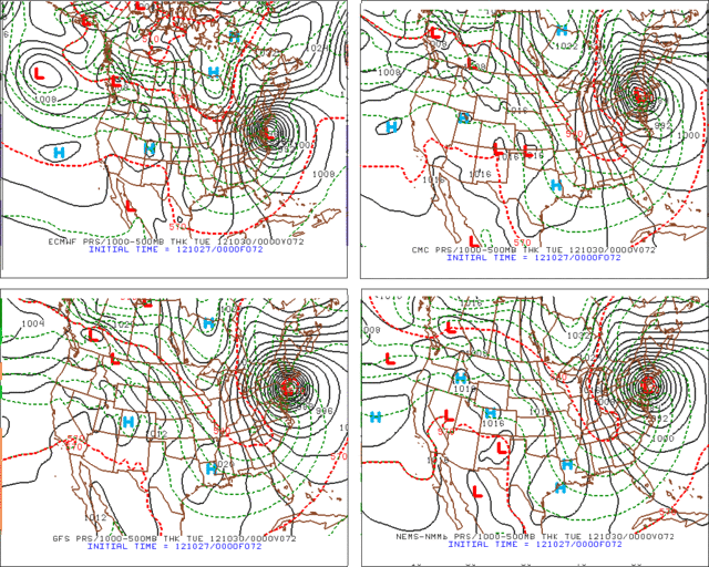
The 00Z (8PM EDT) runs of the major global models have really consolidated not only on a target area but on a target time. Up until now they were pretty divergent on landfall time. Now all of them have somewhere just south of New York City near 8PM on Monday evening (2012-10-30 00z). That is the worst possible outcome for the Jersey shore, NYC and Long Island as far as coastal surge damage is concerned, especially due to the long period of onshore winds and rising water that will occur before Sandy gets onshore. Just terrible if this plays out.
P.S. I threw in the NAM just because I could, lol. No, actually I added it in because although we serious tropical meteorologists never use it, when it agrees with the global models that is dotting the i and crossing the t.

Image
0 likes   

User avatar
Listeri69
Tropical Low
Tropical Low
Posts: 24
Age: 47
Joined: Wed Sep 01, 2010 3:08 pm
Location: Meriden CT

Re: ATL: SANDY - Hurricane - Discussion

#1710 Postby Listeri69 » Sat Oct 27, 2012 3:53 am

What I would like to know is will we be getting tropical storm winds where I am in central Connecticut. I think the reason a lot of people are shrugging at this (I'm not one of them) is we went through Irene and last years halloween nor'easter with little damage. I have prepared and got everything I need from flashlights, water to more gas for the outside grill just in case we loose power again. but I can't help thinking most people here have never been in a situation in fact a lot of my friends from around here are using the phrase bring it on.... Were not florida or the gulf we don't see these very oftern and usually they are pretty weak by the time they get here so people are just expecting heavy rain and for it to be a bit windier than usual, the only ones who I can see who have any concern are the ones who live on the immediate coast and can see the ocean from their windows....
0 likes   
Scotland the only place where you can get a suntan and trench foot on the same day :)

GoneBabyGone
Tropical Storm
Tropical Storm
Posts: 101
Joined: Sat Aug 30, 2008 4:28 pm

Re: ATL: SANDY - Hurricane - Discussion

#1711 Postby GoneBabyGone » Sat Oct 27, 2012 4:30 am

The fact that media outlets are running Sandy being downgraded from a Hurricane to a TS as a "breaking news" alert is troubling.
0 likes   

WeatherGuesser
Category 5
Category 5
Posts: 2672
Joined: Tue Jun 29, 2010 6:46 am

Re: ATL: SANDY - Hurricane - Discussion

#1712 Postby WeatherGuesser » Sat Oct 27, 2012 4:31 am

Listeri69 wrote:What I would like to know is will we be getting tropical storm winds where I am in central Connecticut.


Be prepared for the possibility of no power for a week. Be prepared for fallen trees and limbs.
0 likes   

Chris_in_Tampa
Category 5
Category 5
Posts: 5075
Age: 41
Joined: Thu Jun 21, 2007 11:06 pm
Location: Tampa, Florida, USA
Contact:

Re: ATL: SANDY - Hurricane - Discussion

#1713 Postby Chris_in_Tampa » Sat Oct 27, 2012 4:46 am

GoneBabyGone wrote:The fact that media outlets are running Sandy being downgraded from a Hurricane to a TS as a "breaking news" alert is troubling.

If only the 63 knot SFMR reading (10 second average surface wind estimate) had occurred a little earlier than 4:54am EDT, and transmitted at 4:57am EDT, they could have had at least a little something to justify keeping it a hurricane.
0 likes   

User avatar
GCANE
S2K Supporter
S2K Supporter
Posts: 11500
Joined: Mon Oct 22, 2007 8:03 am

Re: ATL: SANDY - Tropical Storm - Discussion

#1714 Postby GCANE » Sat Oct 27, 2012 6:19 am

Starting to entrain the UL PV.

http://tropic.ssec.wisc.edu/real-time/a ... g8vor1.GIF


Dr Maue:
PV filament/trough that's going to absorb Sandy & dominate whole E. USA sends bone-dry air to Miami & record cold

http://twitter.com/RyanMaue/status/2620 ... to/1/large


Coherent 500 mb (midlevel) warm-core to pinwheel Fujiwhara style in clutches of PV arm/filament.

http://twitter.com/RyanMaue/status/2620 ... to/1/large
0 likes   

User avatar
GCANE
S2K Supporter
S2K Supporter
Posts: 11500
Joined: Mon Oct 22, 2007 8:03 am

Re: ATL: SANDY - Tropical Storm - Discussion

#1715 Postby GCANE » Sat Oct 27, 2012 6:37 am

Starting to see more Ozone entering the system indicating a lowering of the tropopause and transition to a nor'easter type system.

http://cimss.ssec.wisc.edu/goes/rt/imag ... 1.1000.gif
0 likes   

User avatar
Cyclenall
Category 5
Category 5
Posts: 6666
Joined: Thu Jun 08, 2006 10:01 pm
Location: Ontario, Canada

Re: ATL: SANDY - Tropical Storm - Discussion

#1716 Postby Cyclenall » Sat Oct 27, 2012 7:00 am

H. 961 mb
I. 9 C / 3657 m
J. 12 C / 3622 m
K. 10 C / NA
L. SPIRAL BANDING
M. NA
N. 12345 / NA
O. 1 / 1
P. NOAA2 1418A SANDY OB 13
MAX FL WIND 53 KT NW QUAD 10:18:12Z
SST 27.2 IN CENTER FROM AXBT
SONDE SPLASH WITH 6 KTS WIND

:eek: Its starting children, its starting. That is an incredible drop in pressure in such a short time if this is valid.

I also notice its appearance is starting to change in a different way than just a typical ET transition. Some good rotation at the center.

TWN in Canada is also calling this a "Storm of the Century."
0 likes   

xironman
S2K Supporter
S2K Supporter
Posts: 2522
Joined: Sun Jun 10, 2007 4:53 pm
Location: NoVA

Re: ATL: SANDY - Tropical Storm - Discussion

#1717 Postby xironman » Sat Oct 27, 2012 7:06 am

ozonepete wrote:P.S. I threw in the NAM just because I could, lol. No, actually I added it in because although we serious tropical meteorologists never use it, when it agrees with the global models that is dotting the i and crossing the t.

By then it is basically extra-tropical in the mid-latitudes within 72hrs, I have no problem with the NAM in that setup and timeframe
0 likes   

User avatar
x-y-no
Category 5
Category 5
Posts: 8359
Age: 65
Joined: Wed Aug 11, 2004 12:14 pm
Location: Fort Lauderdale, FL

Re: ATL: SANDY - Tropical Storm - Discussion

#1718 Postby x-y-no » Sat Oct 27, 2012 7:07 am

Cyclenall wrote:H. 961 mb
I. 9 C / 3657 m
J. 12 C / 3622 m
K. 10 C / NA
L. SPIRAL BANDING
M. NA
N. 12345 / NA
O. 1 / 1
P. NOAA2 1418A SANDY OB 13
MAX FL WIND 53 KT NW QUAD 10:18:12Z
SST 27.2 IN CENTER FROM AXBT
SONDE SPLASH WITH 6 KTS WIND

:eek: Its starting children, its starting. That is an incredible drop in pressure in such a short time if this is valid.

I also notice its appearance is starting to change in a different way than just a typical ET transition. Some good rotation at the center.

TWN in Canada is also calling this a "Storm of the Century."


That pressure was returned by a dropsonde, so yes it's definitely valid.
0 likes   

User avatar
wxman57
Moderator-Pro Met
Moderator-Pro Met
Posts: 22980
Age: 67
Joined: Sat Jun 21, 2003 8:06 pm
Location: Houston, TX (southwest)

Re: ATL: SANDY - Hurricane - Discussion

#1719 Postby wxman57 » Sat Oct 27, 2012 7:08 am

Back to hurricane strength as per recon reports NW of center.

As for central Connecticut, expect winds in the 40-50 mph range for an extended period on Monday night/Tuesday morning. No structural damage to homes/businesses but widespread power outages that will last for quite a while.
0 likes   

User avatar
TheEuropean
Professional-Met
Professional-Met
Posts: 1796
Age: 59
Joined: Tue Sep 20, 2005 3:17 pm
Location: Voerde, Germany
Contact:

#1720 Postby TheEuropean » Sat Oct 27, 2012 7:09 am

Hurricane again:

BULLETIN
HURRICANE SANDY INTERMEDIATE ADVISORY NUMBER 20A
NWS NATIONAL HURRICANE CENTER MIAMI FL AL182012
800 AM EDT SAT OCT 27 2012

...AIR FORCE AIRCRAFT FINDS HURRICANE-FORCE WINDS AGAIN...

SUMMARY OF 800 AM EDT...1200 UTC...INFORMATION
----------------------------------------------
LOCATION...28.8N 76.8W
ABOUT 165 MI...270 KM N OF GREAT ABACO ISLAND
ABOUT 335 MI...540 KM SE OF CHARLESTON SOUTH CAROLINA
MAXIMUM SUSTAINED WINDS...75 MPH...120 KM/H
PRESENT MOVEMENT...NNE OR 20 DEGREES AT 10 MPH...17 KM/H
MINIMUM CENTRAL PRESSURE...960 MB...28.35 INCHES
0 likes   


Return to “2012”

Who is online

Users browsing this forum: No registered users and 5 guests