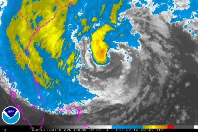
ATL: SANDY - Remnants - Discussion

Moderator: S2k Moderators

Message
Author
ozonepete
Professional-Met
Professional-Met
Posts: 4743
Joined: Mon Sep 07, 2009 3:23 pm
Location: From Ozone Park, NYC / Now in Brooklyn, NY

Re: ATL: SANDY - Hurricane - Discussion

#1921 Postby ozonepete » Sat Oct 27, 2012 6:12 pm

CrazyC83 wrote:
ozonepete wrote:
MiamiensisWx wrote:All these trends just go to show that you really need a major hurricane accelerating from the Bahamas, rather than a late-season nor’easter-type hybrid, and a major hurricane that phases directly (à la 1938, a hybrid that really phased completely due to its location in the jet entrance), to really deliver the full punch of high winds and large surge to the Mid-Atlantic and the Northeast.


Just for you: http://en.wikipedia.org/wiki/Ash_Wednes ... rm_of_1962
:)


If Irene had this setup, how would it have been different?


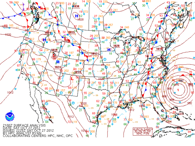
It really doesn't matter whether the storm is tropical in origin or not or where it's coming from. It's the amount of time that high water is present while onshore winds are unusually strong and occurring at high tide. Also, it is very important whether the storm is intensifying or weakening. Irene moved fairly quickly and was a cat 1 weakening to a TS as it approached NYC. Thus there was only a few hours of high water before the center passed and winds shifted to offshore. With Sandy there will be 10 feet or so of high water for many many hours before the center approaches and it won't be weakening. As it mocves onto the Jersey coast it will push a storm surge into NY harbor and then winds will shift southeast to south and stay that way until Sandy turns north and passes east of us again. Thus we could have flooding for many many hours.
Last edited by ozonepete on Sat Oct 27, 2012 6:13 pm, edited 1 time in total.
0 likes   

KBBOCA
S2K Supporter
S2K Supporter
Posts: 1559
Joined: Fri Sep 05, 2003 5:27 am
Location: Formerly Boca Raton, often West Africa. Currently Charlotte NC

#1922 Postby KBBOCA » Sat Oct 27, 2012 6:12 pm

For those praying, I've been posting prayers related to Sandy (along with links and information to help people pray) at a blog I contribute to occasionally.

The Hurricane Sandy posts and prayers are here:
http://anglicanprayer.wordpress.com/tag ... ane-sandy/
0 likes   

User avatar
Macrocane
Category 5
Category 5
Posts: 4218
Age: 36
Joined: Sun May 24, 2009 5:35 pm
Location: El Salvador

Re: ATL: SANDY - Hurricane - Discussion

#1923 Postby Macrocane » Sat Oct 27, 2012 6:14 pm

Look at that huuuge circulation, it the same size of the entire US East Coast.

Image
0 likes   

ozonepete
Professional-Met
Professional-Met
Posts: 4743
Joined: Mon Sep 07, 2009 3:23 pm
Location: From Ozone Park, NYC / Now in Brooklyn, NY

Re: ATL: SANDY - Hurricane - Discussion

#1924 Postby ozonepete » Sat Oct 27, 2012 6:24 pm

:uarrow: Yup macro, massive circulation.

Convection building over the center again.

Image
Last edited by ozonepete on Sat Oct 27, 2012 6:25 pm, edited 1 time in total.
0 likes   

KBBOCA
S2K Supporter
S2K Supporter
Posts: 1559
Joined: Fri Sep 05, 2003 5:27 am
Location: Formerly Boca Raton, often West Africa. Currently Charlotte NC

#1925 Postby KBBOCA » Sat Oct 27, 2012 6:24 pm

I just found this very helpful blog entry with links to the CERA (Coastal Emergency Risks Assessment) storm surge maps for the NYC Metro area:

http://originalweatherblog.blogspot.com ... storm.html

Image

Image


IF I understand correctly [BIG IF - I could be WRONG!] those two maps shown are specifically tied to the projected landfall of Sandy, NOT generalized SLOSH maps. And of course the model would change if the landfall point changes...

Here again is the NYC Evacuation Zone map.
http://www.nyc.gov/html/oem/downloads/p ... nglish.pdf

Zone A and Zone B look to be at considerable risk.

I'M JUST AN AMATEUR!!! LISTEN TO THE EXPERTS!!!
0 likes   

monicaei
Tropical Storm
Tropical Storm
Posts: 114
Joined: Mon Aug 25, 2008 4:58 pm

#1926 Postby monicaei » Sat Oct 27, 2012 6:26 pm

What will be the defining characteristics of the trasnition from tropical to hybrid/extra tropical?
0 likes   

ozonepete
Professional-Met
Professional-Met
Posts: 4743
Joined: Mon Sep 07, 2009 3:23 pm
Location: From Ozone Park, NYC / Now in Brooklyn, NY

Re:

#1927 Postby ozonepete » Sat Oct 27, 2012 6:26 pm

KBBOCA wrote:I just found this very helpful blog entry with links to the CERA (Coastal Emergency Risks Assessment) storm surge maps for the NYC Metro area:
IF I understand correctly [BIG IF - I could be WRONG!] those two maps shown are specifically tied to the projected landfall of Sandy, NOT generalized SLOSH maps. And of course the model would change if the landfall point changes...


You are correct. :)
0 likes   

ozonepete
Professional-Met
Professional-Met
Posts: 4743
Joined: Mon Sep 07, 2009 3:23 pm
Location: From Ozone Park, NYC / Now in Brooklyn, NY

Re:

#1928 Postby ozonepete » Sat Oct 27, 2012 6:33 pm

monicaei wrote:What will be the defining characteristics of the trasnition from tropical to hybrid/extra tropical?


You will start to see a cold front trailing from the center of sandy down to the southeast and south. When the upper trough reaches Sandy and they start to merge, you will see the cold front easily on the satellite image and it will be drawn in on the surface maps from the HPC. Here is a very good example from the Halloween noreaster from last year (though this was never tropical), these images are what you'll be looking for in Sandy as it changes over.

You can follow the satellite here: http://www.ssd.noaa.gov/goes/east/eaus/flash-rgb.html
And the surface charts here: http://www.hpc.ncep.noaa.gov/sfc/namussfcwbg.gif

Image

Image
0 likes   

KBBOCA
S2K Supporter
S2K Supporter
Posts: 1559
Joined: Fri Sep 05, 2003 5:27 am
Location: Formerly Boca Raton, often West Africa. Currently Charlotte NC

#1929 Postby KBBOCA » Sat Oct 27, 2012 6:35 pm

The blogger at "The original weather blog" linked in my previous post (http://originalweatherblog.blogspot.com/) has created some graphics to suggest areas likely to be most affected by winds, power outages, and snow.

DISCLAIMER: the first two graphics below are created by a blogger about whom I don't know much, so treat them with caution. I don't know how reliable they are. It's just one person's analysis of the data.

Image

Image

both of those graphics from here:
originalweatherblog.blogspot.com/2012/10/major-impacts-expected-from-sandy-from.html?

Here's the snow graphic - the GFS model forecast:

Image

from here: http://originalweatherblog.blogspot.com ... at-as.html
0 likes   

User avatar
brunota2003
S2K Supporter
S2K Supporter
Posts: 9476
Age: 34
Joined: Sat Jul 30, 2005 9:56 pm
Location: Stanton, KY...formerly Havelock, NC
Contact:

#1930 Postby brunota2003 » Sat Oct 27, 2012 6:38 pm

Wow! All of Staten Island is under water in that image. That is mind boggling. How many homes would be flooded?
0 likes   
Just a small town southern boy helping other humans.

ozonepete
Professional-Met
Professional-Met
Posts: 4743
Joined: Mon Sep 07, 2009 3:23 pm
Location: From Ozone Park, NYC / Now in Brooklyn, NY

Re: ATL: SANDY - Hurricane - Discussion

#1931 Postby ozonepete » Sat Oct 27, 2012 6:41 pm

Btw, monicaei (and everyone else), here is a recent satellite image and latest surface map from HPC. You can Sandy is still mostly tropical and there are no fronts attached. That won't happen til Monday.

Image

Image
0 likes   

monicaei
Tropical Storm
Tropical Storm
Posts: 114
Joined: Mon Aug 25, 2008 4:58 pm

Re: Re:

#1932 Postby monicaei » Sat Oct 27, 2012 6:45 pm

ozonepete wrote:
monicaei wrote:What will be the defining characteristics of the trasnition from tropical to hybrid/extra tropical?


You will start to see a cold front trailing from the center of sandy down to the southeast and south. When the upper trough reaches Sandy and they start to merge, you will see the cold front easily on the satellite image and it will be drawn in on the surface maps from the HPC. Here is a very good example from the Halloween noreaster from last year (though this was never tropical), these images are what you'll be looking for in Sandy as it changes over.

You can follow the satellite here: http://www.ssd.noaa.gov/goes/east/eaus/flash-rgb.html
And the surface charts here: http://www.hpc.ncep.noaa.gov/sfc/namussfcw
ms/z174/philnyc_2007/sfchpc2011-10-292100.gif[/img]


Thanks. Sandy looks like an inverted version of that image at this point. What happens to the massive wind/moisture field to the N when the front comes in and trails to the south?
Last edited by monicaei on Sat Oct 27, 2012 6:48 pm, edited 2 times in total.
0 likes   

ozonepete
Professional-Met
Professional-Met
Posts: 4743
Joined: Mon Sep 07, 2009 3:23 pm
Location: From Ozone Park, NYC / Now in Brooklyn, NY

Re:

#1933 Postby ozonepete » Sat Oct 27, 2012 6:46 pm

brunota2003 wrote:Wow! All of Staten Island is under water in that image. That is mind boggling. How many homes would be flooded?


Most of Staten Island is well over 10 feet above sea level because it is very hilly island so most of the island won't go under water. It even has a few spots that have the highest land on the northeast coast. But still, they will have severe flooding at their coastline where many homes are only a few feet above sea level. It will be pretty awful if this pans out.
0 likes   

ozonepete
Professional-Met
Professional-Met
Posts: 4743
Joined: Mon Sep 07, 2009 3:23 pm
Location: From Ozone Park, NYC / Now in Brooklyn, NY

Re: Re:

#1934 Postby ozonepete » Sat Oct 27, 2012 6:49 pm

monicaei wrote:Thanks. It looks like you inverted that image at this point. What happens to the massive wind/moisture field to the N when the front comes in and trails to the south?


The moisture/heaviest precip will be concentrated near the west and center of the low while offshore and then concentrate on the north and eastern side of the low after it makes landfall. Winds will be highest anywhere to the right of the direction of motion.
0 likes   

User avatar
GCANE
S2K Supporter
S2K Supporter
Posts: 11500
Joined: Mon Oct 22, 2007 8:03 am

Re: ATL: SANDY - Hurricane - Discussion

#1935 Postby GCANE » Sat Oct 27, 2012 6:52 pm

Ozone column is showing it is still detached from the front.

http://cimss.ssec.wisc.edu/goes/rt/imag ... 1.2300.gif

Extra-trop should kick in when strong yellows & greens entrain around Sandy indicating UL PV working into the core.
0 likes   

monicaei
Tropical Storm
Tropical Storm
Posts: 114
Joined: Mon Aug 25, 2008 4:58 pm

Re: Re:

#1936 Postby monicaei » Sat Oct 27, 2012 6:53 pm

ozonepete wrote:
monicaei wrote:Thanks. It looks like you inverted that image at this point. What happens to the massive wind/moisture field to the N when the front comes in and trails to the south?


The moisture/heaviest precip will be concentrated near the west and center of the low while offshore and then concentrate on the north and eastern side of the low after it makes landfall. Winds will be highest anywhere to the right of the direction of motion.


So it will still keep the "right front quad" dynamic typical of a tropical system?

This is truly fascinating stuff, I don't know much about weather but I have been watching the tropics for years. This is new to me! Eating a cold front and hard left turn into the eastern seaboard. That's crazy
Last edited by monicaei on Sat Oct 27, 2012 6:54 pm, edited 1 time in total.
0 likes   

User avatar
ROCK
Category 5
Category 5
Posts: 9484
Age: 54
Joined: Tue Aug 17, 2004 7:30 am
Location: Kemah, Texas

Re: ATL: SANDY - Hurricane - Discussion

#1937 Postby ROCK » Sat Oct 27, 2012 6:53 pm

why is it I go to a NEWS website and this is not front page? we are talking the largest city in NA that will be impacted...
0 likes   

KBBOCA
S2K Supporter
S2K Supporter
Posts: 1559
Joined: Fri Sep 05, 2003 5:27 am
Location: Formerly Boca Raton, often West Africa. Currently Charlotte NC

#1938 Postby KBBOCA » Sat Oct 27, 2012 6:54 pm

Thanks Ozone Pete. You beat me to it. I was about to go looking for elevation maps for Staten Island. I seemed to remember it being pretty hilly (not counting of course perhaps the biggest hill of them all - the freshkills landfill?!)
0 likes   

User avatar
cycloneye
Admin
Admin
Posts: 145555
Age: 68
Joined: Thu Oct 10, 2002 10:54 am
Location: San Juan, Puerto Rico

Re: ATL: SANDY - Hurricane - Discussion

#1939 Postby cycloneye » Sat Oct 27, 2012 6:57 pm

BULLETIN
HURRICANE SANDY INTERMEDIATE ADVISORY NUMBER 22A
NWS NATIONAL HURRICANE CENTER MIAMI FL AL182012
800 PM EDT SAT OCT 27 2012

...SANDY CONTINUING NORTHEASTWARD WHILE HIGH WIND WATCHES AND
WARNINGS REMAIN IN EFFECT FOR THE MID-ATLANTIC STATES AND SOUTHERN
NEW ENGLAND...
...SIGNIFICANT STORM SURGE IS ALSO EXPECTED...


SUMMARY OF 800 PM EDT...0000 UTC...INFORMATION
----------------------------------------------
LOCATION...30.5N 74.7W
ABOUT 355 MI...570 KM ESE OF CHARLESTON SOUTH CAROLINA
ABOUT 330 MI...530 KM S OF CAPE HATTERAS NORTH CAROLINA
MAXIMUM SUSTAINED WINDS...75 MPH...120 KM/H
PRESENT MOVEMENT...NE OR 35 DEGREES AT 13 MPH...20 KM/H
MINIMUM CENTRAL PRESSURE...961 MB...28.38 INCHES
0 likes   
Visit the Caribbean-Central America Weather Thread where you can find at first post web cams,radars
and observations from Caribbean basin members Click Here

User avatar
brunota2003
S2K Supporter
S2K Supporter
Posts: 9476
Age: 34
Joined: Sat Jul 30, 2005 9:56 pm
Location: Stanton, KY...formerly Havelock, NC
Contact:

Re: Re:

#1940 Postby brunota2003 » Sat Oct 27, 2012 6:58 pm

ozonepete wrote:
brunota2003 wrote:Wow! All of Staten Island is under water in that image. That is mind boggling. How many homes would be flooded?


Most of Staten Island is well over 10 feet above sea level because it is very hilly island so most of the island won't go under water. It even has a few spots that have the highest land on the northeast coast. But still, they will have severe flooding at their coastline where many homes are only a few feet above sea level. It will be pretty awful if this pans out.

Ah. I don't know the topography of the area, other than there are hills, and there used to be a LOT of trees...once upon a time.
0 likes   
Just a small town southern boy helping other humans.


Return to “2012”

Who is online

Users browsing this forum: No registered users and 3 guests