3. ADDTIONAL DAY OUTLOOK: POSSIBLE LOW LEVEL INVEST
AT 11/1800Z NEAR 13N 56W.
ATL: HELENE - Post-Tropical
Moderator: S2k Moderators
-
floridasun78
- Category 5

- Posts: 3755
- Joined: Sun May 17, 2009 10:16 pm
- Location: miami fl
Re: ATL: INVEST 92L
0 likes

Re: ATL: INVEST 92L - Models
That is a strong trof for August so I have my doubts...
00Z NOGAPS.....sending 92L towards the main islands...might slip over them...
https://www.fnmoc.navy.mil/wxmap_cgi/cg ... t=Tropical
00Z NOGAPS.....sending 92L towards the main islands...might slip over them...
https://www.fnmoc.navy.mil/wxmap_cgi/cg ... t=Tropical
0 likes
Re: ATL: INVEST 92L
looks like 92L took a dive to the SW some.....not at all surprised with the big high above it....
0 likes
-
Weatherfreak000
Re: ATL: INVEST 92L
Definitely does appear to be moving south of west now....interesting for sure. I wonder how this will translate to future track? I can see this guy still making it to the Caribbean IMO.
0 likes
-
ConvergenceZone
.gif)
- Category 5
- Posts: 5241
- Joined: Fri Jul 29, 2005 1:40 am
- Location: Northern California
Re: ATL: INVEST 92L
ROCK wrote:looks like 92L took a dive to the SW some.....not at all surprised with the big high above it....
Hmm, in my opinion that just increases the chance of it going into the carib as opposed to recurving...I mean, sure it's north of where Ernesto was, but Ernesto ended up going into Mexico because it was so far south. Thus I would think that 92L(if it develops) has a greater chance of going into the carib into the central or eastern gulf..
0 likes


Re: ATL: INVEST 92L
cycloneye wrote:Up to 70%
Special Tropical Weather Outlook
THE CIRCULATION ASSOCIATED WITH A SMALL LOW PRESSURE SYSTEM LOCATED
ABOUT 950 MILES WEST OF THE SOUTHERN CAPE VERDE ISLANDS HAS
CONTINUED TO BECOME BETTER DEFINED OVER THE PAST SEVERAL HOURS.
THUNDERSTORM ACTIVITY IS ORGANIZING AROUND THE SURFACE CENTER...AND
UPPER-LEVEL WINDS ARE EXPECTED TO BE CONDUCIVE FOR THE DEVELOPMENT
OF A TROPICAL DEPRESSION OVER THE NEXT COUPLE OF DAYS. THIS SYSTEM
HAS A HIGH CHANCE...70 PERCENT...OF BECOMING A TROPICAL CYCLONE
DURING THE NEXT 48 HOURS AS IT MOVES WESTWARD AT ABOUT 15 MPH.
I'm kind of curious as to why a "Special Tropical Weather Outlook" would be issued.
The % only went from 50 to 70 and it could have been taken care of in the regularly scheduled 2:00 AM outlook.
I would think that a STWO would be issued if they were announcing that advisories were about to be issued, not to just increase the % chance of a tropical cyclone developing in the next 48 hours.
Just curious......
0 likes
-
Weatherfreak000
Re: ATL: INVEST 92L
Continues to organize, TD tomorrow a real possibility. Still getting pushed south of west he's under 15 N now...looking interesting
0 likes

Re: ATL: INVEST 92L
Is anyone still awake? Is that an eye i see in last loop on nhc water vapor image. Seems to bee spinning really fast on last two frames
0 likes
Personal Forecast Disclaimer:
The posts in this forum are NOT official forecast and should not be used as such. They are just the opinion of the poster and may or may not be backed by sound meteorological data. They are NOT endorsed by any professional institution or storm2k.org. For official information, please refer to the NHC and NWS products.
The posts in this forum are NOT official forecast and should not be used as such. They are just the opinion of the poster and may or may not be backed by sound meteorological data. They are NOT endorsed by any professional institution or storm2k.org. For official information, please refer to the NHC and NWS products.
Re: ATL: INVEST 92L
stephen23 wrote:Is anyone still awake? Is that an eye i see in last loop on nhc water vapor image. Seems to bee spinning really fast on last two frames
no thats not an eye....its got a long way to go before that happens...
0 likes

Re: ATL: INVEST 92L
stephen23 wrote:Is anyone still awake? Is that an eye i see in last loop on nhc water vapor image. Seems to bee spinning really fast on last two frames
No. Eyes generally only form on intense tropical cyclones, such as hurricanes -- as of now, we do not even have a tropical depression, simply a tropical low. Also, the 'eye' does not appear to have intense thunderstorms surrounding it in an "eye wall" like fashion. What you are seeing is just an area of slightly weaker thunderstorms. I would suggest reading the "Eye (Cyclone)" Page on wikipedia if you want more info on them.
Hope it helped~
0 likes
I'm no expert, everything I say should be taken with a large amount of salt. I could easily be very, very wrong.
~Zanthe Go Coyotes~
~Zanthe Go Coyotes~

Re: ATL: INVEST 92L
Personal Forecast Disclaimer:
The posts in this forum are NOT official forecast and should not be used as such. They are just the opinion of the poster and may or may not be backed by sound meteorological data. They are NOT endorsed by any professional institution or storm2k.org. For official information, please refer to the NHC and NWS products.
My thoughts/forecast
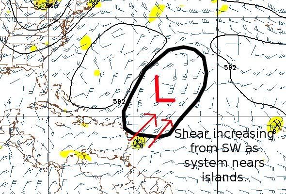
I think 92L will become a tropical cyclone sometime on Friday (although I wouldn't rule out later today). I think it will slowly intensify over the next 2 to 3 days becoming a 40 to 50kt tropical storm. It will start to feel SW shear from the TUTT thats developing near Bermuda thats forecated to move south. It will cross the middle islands (near Martinique or St Lucia) as a weakening tropical storm/tropical depression.
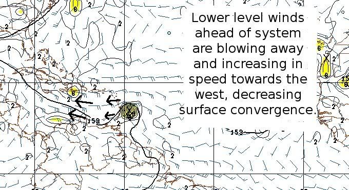
After that it will have the same problems that Ernesto did over the Eastern Caribbean. The LL flow will be too strong causing a lack of surface convergence and preventing the system from stacking.

The posts in this forum are NOT official forecast and should not be used as such. They are just the opinion of the poster and may or may not be backed by sound meteorological data. They are NOT endorsed by any professional institution or storm2k.org. For official information, please refer to the NHC and NWS products.
My thoughts/forecast
I think 92L will become a tropical cyclone sometime on Friday (although I wouldn't rule out later today). I think it will slowly intensify over the next 2 to 3 days becoming a 40 to 50kt tropical storm. It will start to feel SW shear from the TUTT thats developing near Bermuda thats forecated to move south. It will cross the middle islands (near Martinique or St Lucia) as a weakening tropical storm/tropical depression.
After that it will have the same problems that Ernesto did over the Eastern Caribbean. The LL flow will be too strong causing a lack of surface convergence and preventing the system from stacking.
0 likes
-
somethingfunny

- ChatStaff

- Posts: 3926
- Age: 37
- Joined: Thu May 31, 2007 10:30 pm
- Location: McKinney, Texas
Great post, RL3AO!
My own opinion is even less bullish than that. I want to see 92L sustain convection for more than just one D-Max period. It looks great right now, but it's small, it was absolutely terrible looking just 18 hours ago, and the global models have only recently come on board with any development at all. It could make a run at development and a short-lived tropical storm (Flash Gordon?) could occur... but I'd personally set the odds at 50% development, 49% no development, and 1% hurricane.
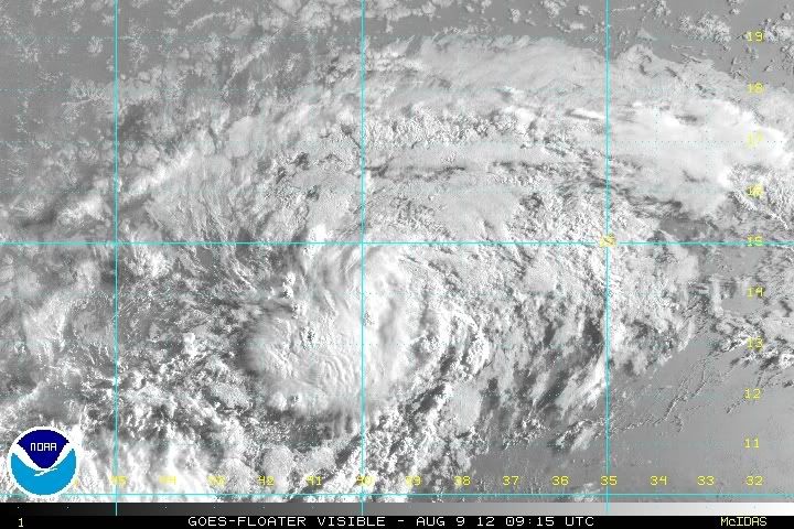
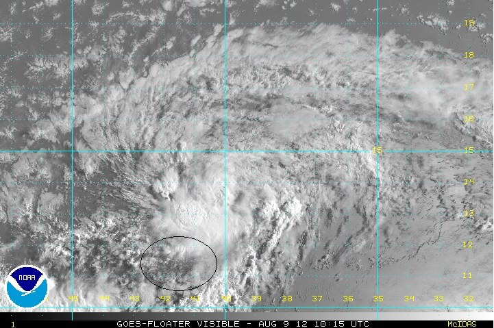
It's definitely got some spin, but is it a tropical cyclone? If there is a LLC, you can see it at the beginning of this loop at the eastern side of the convection, and the convection totally sinks to the south of the LLC (which, while we can't see it, should have continued moving to the west) by the end of the loop. I think visible imagery will show a naked vortex to the north of a dying convective mass. Whether or not the NHC decides to classify that, or if the hypothetical LLC regenerates convection, are two very good questions.

My own opinion is even less bullish than that. I want to see 92L sustain convection for more than just one D-Max period. It looks great right now, but it's small, it was absolutely terrible looking just 18 hours ago, and the global models have only recently come on board with any development at all. It could make a run at development and a short-lived tropical storm (Flash Gordon?) could occur... but I'd personally set the odds at 50% development, 49% no development, and 1% hurricane.
It's definitely got some spin, but is it a tropical cyclone? If there is a LLC, you can see it at the beginning of this loop at the eastern side of the convection, and the convection totally sinks to the south of the LLC (which, while we can't see it, should have continued moving to the west) by the end of the loop. I think visible imagery will show a naked vortex to the north of a dying convective mass. Whether or not the NHC decides to classify that, or if the hypothetical LLC regenerates convection, are two very good questions.
0 likes
I am not a meteorologist, and any posts made by me are not official forecasts or to be interpreted as being intelligent. These posts are just my opinions and are probably silly opinions.
-
ts_kakolina

- Tropical Depression

- Posts: 58
- Joined: Wed Jul 13, 2005 8:27 am
- Location: Carolina, Puerto Rico


Convection has dropped way southwards, almost too far southerly. I'm wondering whether uncle shear may be visiting a little ealrier than expected, that convective dip reminds me alot ofwhat happened to Chris a few years back.
Then again it could just as easily be the system has indeed dived further south and if thats the case then another Ernesto looks likely IMO in terms of track, straight west into CA.
Then again it could just as easily be the system has indeed dived further south and if thats the case then another Ernesto looks likely IMO in terms of track, straight west into CA.
0 likes
Personal Forecast Disclaimer:
The posts in this forum are NOT official forecast and should not be used as such. They are just the opinion of the poster and may or may not be backed by sound meteorological data. They are NOT endorsed by any professional institution or storm2k.org. For official information, please refer to the NHC and NWS products
The posts in this forum are NOT official forecast and should not be used as such. They are just the opinion of the poster and may or may not be backed by sound meteorological data. They are NOT endorsed by any professional institution or storm2k.org. For official information, please refer to the NHC and NWS products
-
Gustywind

- Category 5
- Posts: 12334
- Joined: Mon Sep 03, 2007 7:29 am
- Location: Baie-Mahault, GUADELOUPE
2 AM TWO
Stays at 70%
000
ABNT20 KNHC 090548
TWOAT
TROPICAL WEATHER OUTLOOK
NWS NATIONAL HURRICANE CENTER MIAMI FL
200 AM EDT THU AUG 9 2012
FOR THE NORTH ATLANTIC...CARIBBEAN SEA AND THE GULF OF MEXICO...
SHOWERS AND THUNDERSTORMS ASSOCIATED WITH A LOW PRESSURE SYSTEM
LOCATED ABOUT 1000 MILES WEST OF THE SOUTHERN CAPE VERDE ISLANDS
HAVE CHANGE LITTLE IN ORGANIZATION. UPPER-LEVEL WINDS APPEAR
CONDUCIVE FOR FURTHER DEVELOPMENT AND A TROPICAL DEPRESSION COULD
FORM OVER THE NEXT COUPLE OF DAYS. THIS SYSTEM HAS A HIGH
CHANCE...70 PERCENT...OF BECOMING A TROPICAL CYCLONE DURING THE
NEXT 48 HOURS AS IT MOVES WESTWARD AT ABOUT 15 MPH.
0 likes
-
Gustywind
- Category 5
- Posts: 12334
- Joined: Mon Sep 03, 2007 7:29 am
- Location: Baie-Mahault, GUADELOUPE
000
AXNT20 KNHC 090558
TWDAT
TROPICAL WEATHER DISCUSSION
NWS NATIONAL HURRICANE CENTER MIAMI FL
205 AM EDT THU AUG 09 2012
TROPICAL WEATHER DISCUSSION FOR NORTH AMERICA...CENTRAL
AMERICA...GULF OF MEXICO...CARIBBEAN SEA...NORTHERN SECTIONS OF
SOUTH AMERICA...AND ATLANTIC OCEAN TO THE AFRICAN COAST FROM THE
EQUATOR TO 32N. THE FOLLOWING INFORMATION IS BASED ON SATELLITE
IMAGERY...WEATHER OBSERVATIONS...RADAR...AND METEOROLOGICAL
ANALYSIS.
BASED ON 0000 UTC SURFACE ANALYSIS AND SATELLITE IMAGERY THROUGH
0515 UTC.
...SPECIAL FEATURES...
TROPICAL WAVE EXTENDS FROM 12N39W TO 15N39W TO 19N37W MOVING W
AT 15 KT. A 1010 MB LOW IS CENTERED ALONG THE WAVE AXIS NEAR
14N39W. A MAXIMUM IN TOTAL PRECIPITABLE WATER IMAGERY IS ALSO
OBSERVED BETWEEN 33W-41W WITH SCATTERED MODERATE CONVECTION
OCCURRING NEAR THE LOW CENTER FROM 13N-15N BETWEEN 38W-40W.
0 likes
-
ouragans

- Category 2

- Posts: 501
- Age: 54
- Joined: Sun Jun 12, 2011 12:09 pm
- Location: Abymes, Guadeloupe F.W.I
- Contact:
Re: ATL: INVEST 92L
Here's Crown Weather post this morning
Source: http://www.crownweather.com/?p=7058
Invest 92L:
I am closely monitoring an area of disturbed weather, designated Invest 92L by the National Hurricane Center, located over the eastern Atlantic this morning. It seems very likely that this system will become our next named storm either as early as late today or more likely during the day on Friday.
Satellite loops over the past several hours indicate that 92L is now tracking west-southwestward rather than westward. This west-southwestward motion is caused by a small ridge of high pressure that is positioned northeast to southwest over the central Atlantic. Environmental conditions are favorable over 92L and are expected to remain favorable for the next couple of days or so. Even with the favorable conditions, I expect slow development and intensification as it tracks westward over the next several days.
Now, what does the future hold for Invest 92L? Well, as I mentioned I do think that it will become our next named storm (Gordon) as early as late today or more likely on Friday. From there, I suspect we will see slow, but steady strengthening with this system potentially impacting the Lesser Antilles, most likely between the islands of Guadeloupe and St. Lucia on Saturday afternoon as a 45 to 55 mph tropical storm. Once 92L/Gordon reaches the Caribbean, it may end up staying as a steady-state tropical storm or weaken due to unfavorable environmental conditions; but, as we saw with Ernesto, it did not dissipate and this could very well become the case with this system late this weekend into next week as it tracks westward across the Caribbean; in fact, it would not surprise me at all to see 92L/Gordon follow an extremely similar path that Ernesto has taken due to that the fact that the upper-level pattern remains the same as it did with Ernesto.
Those of you in the Lesser Antilles, especially between the islands of Guadeloupe and St. Lucia, as well as on the island of Barbados, you should be aware that tropical storm conditions seem likely during the day Saturday and possibly continuing into Saturday evening. Expect tropical storm force winds with gusts to 60 mph, very heavy rainfall with the risk for flash flooding and very rough seas.
Source: http://www.crownweather.com/?p=7058
0 likes
Personal forecast disclaimer
This post is a personal point of view, not an information. Please refer to official statements for life-threatening decisions.
David '79, Frederic '79, Hugo '89, Iris, Luis & Marilyn '95, Georges '98, Lenny '99, Dean '07, Irma '17, Maria '17, Fiona '22, Philippe '23, Tammy '23
16°13'33.3,"6N -61°36'39.5"W
Who is online
Users browsing this forum: No registered users and 57 guests