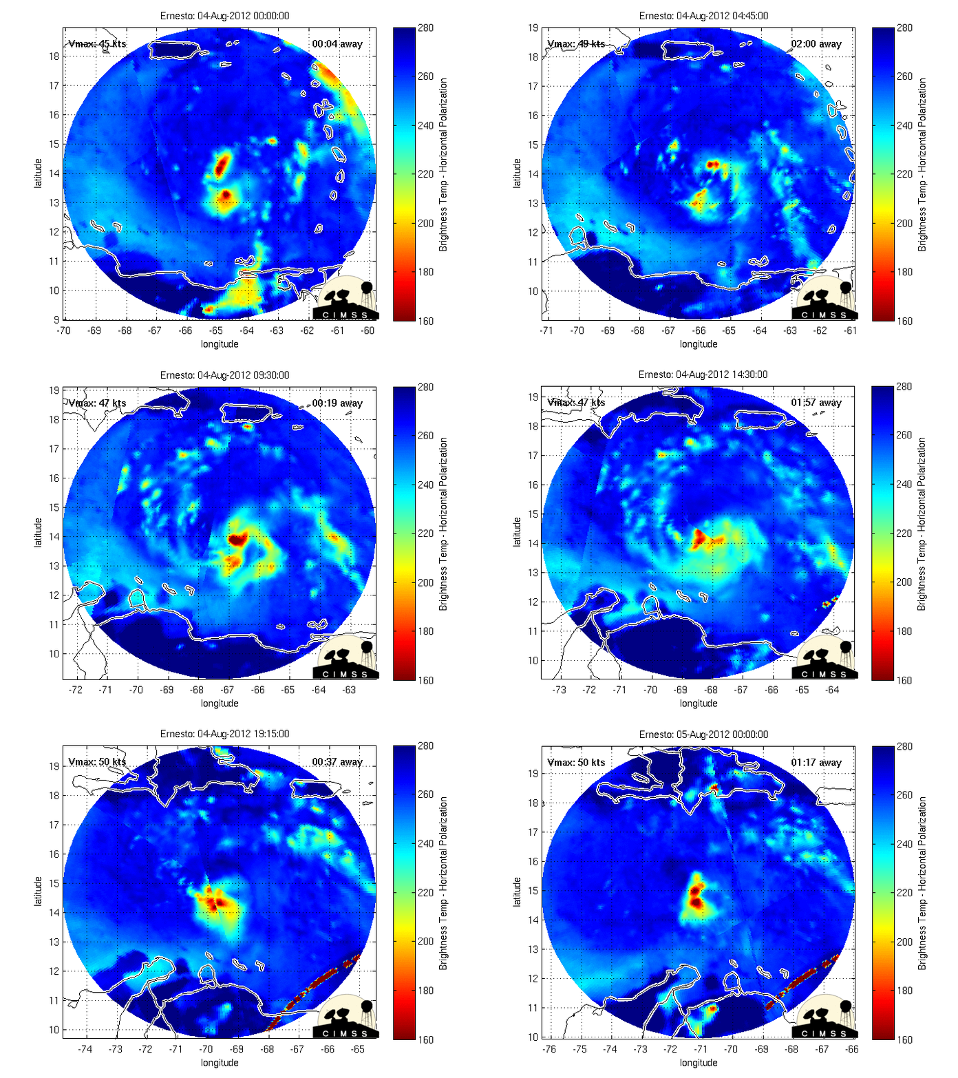
ATL: ERNESTO - Post-Tropical

Moderator: S2k Moderators

Message
Author
User avatar
brunota2003
S2K Supporter
S2K Supporter
Posts: 9476
Age: 34
Joined: Sat Jul 30, 2005 9:56 pm
Location: Stanton, KY...formerly Havelock, NC
Contact:

Re: ATL: ERNESTO - Tropical Storm

#2341 Postby brunota2003 » Sat Aug 04, 2012 12:06 pm

HurricaneAndrew92 wrote:
brunota2003 wrote:
HurricaneAndrew92 wrote:I'd say the Nhc will wait till 5 to upgrade. But what do you guys think 2pm may hold?

Upgrade to what? Definitely not hurricane...recon never found anything to support winds higher than 45 knots...so the current intensity of 45 knots looks good still.

Bad wording

No problem...that is why I included the second tidbit in there.
0 likes   
Just a small town southern boy helping other humans.

User avatar
Rgv20
S2K Supporter
S2K Supporter
Posts: 2466
Age: 39
Joined: Wed Jan 05, 2011 5:42 pm
Location: Edinburg/McAllen Tx

#2342 Postby Rgv20 » Sat Aug 04, 2012 12:08 pm

Thru 108hrs the operational GFS has very good support from the Ensemble Means.

Image


12zUKMET thru 144hrs (Friday Morning) has Ernesto in the SW GOM/BOC.

Image
0 likes   
The following post is NOT an official forecast and should not be used as such. It is just the opinion of the poster and may or may not be backed by sound meteorological data. It is NOT endorsed by any professional institution including storm2k.org For Official Information please refer to the NHC and NWS products.

User avatar
cheezyWXguy
Category 5
Category 5
Posts: 6108
Joined: Mon Feb 13, 2006 12:29 am
Location: Dallas, TX

Re: ATL: ERNESTO - Tropical Storm

#2343 Postby cheezyWXguy » Sat Aug 04, 2012 12:08 pm

HurricaneAndrew92 wrote:
RL3AO wrote:
HurricaneAndrew92 wrote:I'd say the Nhc will wait till 5 to upgrade. But what do you guys think 2pm may hold?


Upgrade to what?

Sorry, increase wind speeds if this storm continues intensifying.

They will, but there hasnt yet been any proof of intensification. pressure has dropped a few millibars but there isnt sufficient data to say that this is higher than 45 kts yet. There may well be, and if there isn't now there likely will be later if it continues the trend, but we havent found it yet. Satellite presentation takes a backseat to real time aircraft data.
0 likes   

User avatar
Rgv20
S2K Supporter
S2K Supporter
Posts: 2466
Age: 39
Joined: Wed Jan 05, 2011 5:42 pm
Location: Edinburg/McAllen Tx

Re:

#2344 Postby Rgv20 » Sat Aug 04, 2012 12:11 pm

gatorcane wrote:
The posts in this forum are NOT official forecast and should not be used as such. They are just the opinion of the poster and may or may not be backed by sound meteorological data. They are NOT endorsed by any professional institution or storm2k.org. For official information, please refer to the NHC and NWS products


When were both the GFS and ECMWF both wrong? It's very difficult to go against the grain with those two reliable models. To me this is looking more and more like a BOC/Mexico threat and less a Gulf Coast United States threat


Very true and as of right now odds are that Ernesto will make 2 landfalls in Mexico. To add to your post its not only the GFS and ECMWF but also the UKMET and NOGAPS..
0 likes   
The following post is NOT an official forecast and should not be used as such. It is just the opinion of the poster and may or may not be backed by sound meteorological data. It is NOT endorsed by any professional institution including storm2k.org For Official Information please refer to the NHC and NWS products.

User avatar
Ivanhater
Storm2k Moderator
Storm2k Moderator
Posts: 11162
Age: 38
Joined: Fri Jul 01, 2005 8:25 am
Location: Pensacola

Re: ATL: ERNESTO - Models

#2345 Postby Ivanhater » Sat Aug 04, 2012 12:13 pm

Still today, the models are showing a clear weakness over the central Gulf. It will have to stay weak not to turn into the weakness. Very important to see what Ernie does over the weekend.
0 likes   
Michael

Nederlander
S2K Supporter
S2K Supporter
Posts: 1251
Joined: Sat Jul 19, 2008 4:28 pm
Location: Conroe, TX

Re: ATL: ERNESTO - Tropical Storm

#2346 Postby Nederlander » Sat Aug 04, 2012 12:16 pm

SouthDadeFish wrote:
cheezyWXguy wrote:
Blinhart wrote:
You should never be so confident about RI, you never know about RI, that is why everyone likes to speculate when it might happen.

Im pretty confident. If you'd like to wager that this will be at 974 mb by midnight tonight I'll glad you take you up on it.


Besides your wager, what factors make you so confident about this? Ernesto doesn't even have an impressive circulation right now according to recon data. Almost all the winds in the SE quadrant were out of the S instead of SW. Also the winds on the SW side are very weak. Yes satellite presentation is impressive, but that is not everything. Recon did report anything about Ernesto forming an eyewall yet, and that would probably have to happen first before he can hit 974mb. Building an eyewall takes time.

Tell that to Humberto from 2007. That being said, I believe it is less likely that Ernesto undergoes RI based on what we've seen today. It's amazing how much things change in a matter of hours. I think tomorrow is the day. Let's see if it's core can start to look as beautiful as its sat imagery.

Personal Forecast Disclaimer: The posts in this forum are NOT official forecast and should not be used as such. They are just the opinion of the poster and may or may not be backed by sound meteorological data. They are NOT endorsed by any professional institution or storm2k.org. For official information, please refer to the NHC and NWS products.
0 likes   

User avatar
Dave
Retired Staff
Retired Staff
Posts: 13442
Age: 74
Joined: Tue Aug 01, 2006 3:57 pm
Location: Milan Indiana
Contact:

#2347 Postby Dave » Sat Aug 04, 2012 12:16 pm

Perfect timing....just got home about 15 mins ago and saw the cancelled mission. Guess I'll work on the house this afternoon and IF we don't get the severe weather that's called for our area late this afternoon I'll be ready for the evening mission. If we do get it then I'll be on here late.
0 likes   

User avatar
brunota2003
S2K Supporter
S2K Supporter
Posts: 9476
Age: 34
Joined: Sat Jul 30, 2005 9:56 pm
Location: Stanton, KY...formerly Havelock, NC
Contact:

#2348 Postby brunota2003 » Sat Aug 04, 2012 12:16 pm

Considering no new HDOBs:

NHC, TEAL 70, over.
TEAL 70, NHC, go ahead, over.
NHC, TEAL 70. Mission complete, over.
TEAL 70, NHC. Roger, have a safe flight home, over.
NHC, TEAL 70 Roger that. TEAL 70 out.
0 likes   
Just a small town southern boy helping other humans.

User avatar
Hurricane Andrew
S2K Supporter
S2K Supporter
Posts: 1891
Age: 26
Joined: Sun May 23, 2010 2:53 pm
Location: KS

#2349 Postby Hurricane Andrew » Sat Aug 04, 2012 12:18 pm

Now we enter a 'semi-dark-window', where we have no recon,but we do have vis sat.
0 likes   

The Enthusiast
NREMT-AEMT, WX nerd

Irene '11, Sandy '12, Irma '17 (SAR)

"Hard to think we were born to live this way..." -Wage War

User avatar
SouthDadeFish
Professional-Met
Professional-Met
Posts: 2835
Joined: Thu Sep 23, 2010 2:54 pm
Location: Miami, FL
Contact:

#2350 Postby SouthDadeFish » Sat Aug 04, 2012 12:19 pm

Check out CIMSS ADT:


UW - CIMSS
ADVANCED DVORAK TECHNIQUE
ADT-Version 8.1.3
Tropical Cyclone Intensity Algorithm

----- Current Analysis -----
Date : 04 AUG 2012 Time : 161500 UTC
Lat : 14:27:54 N Lon : 69:02:25 W


CI# /Pressure/ Vmax
4.0 / 989.4mb/ 65.0kt


Final T# Adj T# Raw T#
3.6 3.9 3.9

Center Temp : -71.5C Cloud Region Temp : -70.3C

Scene Type : UNIFORM CDO CLOUD REGION
0 likes   

Shuriken

#2351 Postby Shuriken » Sat Aug 04, 2012 12:19 pm

Unofficial prediction: Ernesto will not markedly intensify until passing the Caribbean pinch-point at 72W; it will be consolidating during this time, however; and there will be a slight northward kink in the track as the LLC tucks under the convective core (which appears be heading toward the center of the pinch-point gap). RI will onset Sunday, and Ernesto will quickly become a large, major hurricane south of (and uncomfortably close to) Jamaica thereafter.


Personal Forecast Disclaimer:
The posts in this forum are NOT official forecast and should not be used as such. They are just the opinion of the poster and may or may not be backed by sound meteorological data. They are NOT endorsed by any professional institution or storm2k.org. For official information, please refer to the NHC and NWS products.
Last edited by RL3AO on Sat Aug 04, 2012 12:33 pm, edited 2 times in total.
Reason: Added disclaimer
0 likes   

User avatar
brunota2003
S2K Supporter
S2K Supporter
Posts: 9476
Age: 34
Joined: Sat Jul 30, 2005 9:56 pm
Location: Stanton, KY...formerly Havelock, NC
Contact:

#2352 Postby brunota2003 » Sat Aug 04, 2012 12:21 pm

CIMSS ADT has been saying at or just under 4.0 (65 knots) for a good portion of today. I stated earlier, it just goes to show that even sat estimates can be way off from time to time.
0 likes   
Just a small town southern boy helping other humans.

User avatar
ROCK
Category 5
Category 5
Posts: 9485
Age: 54
Joined: Tue Aug 17, 2004 7:30 am
Location: Kemah, Texas

Re: ATL: ERNESTO - Tropical Storm

#2353 Postby ROCK » Sat Aug 04, 2012 12:23 pm

I am at a loss why we have 4 t numbers and estimated pressure of 989mb
And recon is telling us different....
0 likes   

pcolaman
Category 1
Category 1
Posts: 380
Age: 61
Joined: Sun Aug 29, 2010 9:33 am
Location: Pensacola Fla

#2354 Postby pcolaman » Sat Aug 04, 2012 12:24 pm

0 likes   

User avatar
Ivanhater
Storm2k Moderator
Storm2k Moderator
Posts: 11162
Age: 38
Joined: Fri Jul 01, 2005 8:25 am
Location: Pensacola

Re: ATL: ERNESTO - Tropical Storm

#2355 Postby Ivanhater » Sat Aug 04, 2012 12:24 pm

Image
0 likes   
Michael

SunnyThoughts
Category 5
Category 5
Posts: 2263
Joined: Wed Jul 09, 2003 12:42 pm
Location: Pensacola, Florida

#2356 Postby SunnyThoughts » Sat Aug 04, 2012 12:27 pm

I think everyone's predictions of Earnie becoming a hurricane will come true as he passes close to Jamaica. From there on out who knows how strong he will become, I just hope landfall happens on a very lightly populated area. Just my opinion, please follow the NHC for official news concerning Earnesto.
0 likes   

User avatar
Dave
Retired Staff
Retired Staff
Posts: 13442
Age: 74
Joined: Tue Aug 01, 2006 3:57 pm
Location: Milan Indiana
Contact:

#2357 Postby Dave » Sat Aug 04, 2012 12:28 pm

From Cycloneye...Next mission departs at 6:00 PM EDT.

FLIGHT TWO -TEAL 71-
A. 05/0000Z, 0600Z
B. AFXXX 0505A ERNESTO
C. 04/2200Z
D. 15.0N 71.2W
E. 04/2330Z TO 05/0600Z
F. SFC TO 10,000 FT

viewtopic.php?f=59&t=113200&st=0&sk=t&sd=a&start=100
0 likes   

SunnyThoughts
Category 5
Category 5
Posts: 2263
Joined: Wed Jul 09, 2003 12:42 pm
Location: Pensacola, Florida

Re: ATL: ERNESTO - Tropical Storm

#2358 Postby SunnyThoughts » Sat Aug 04, 2012 12:29 pm

ROCK wrote:I am at a loss why we have 4 t numbers and estimated pressure of 989mb
And recon is telling us different....


Rock, well we know that they had equipment problems yesterday with readings being off and returned to base. Is this the same plane I wonder? Maybe having the same problems? Only thing I can think of, other than the fact that looks can be deceiving sometimes I guess.
0 likes   

Weatherfreak000

#2359 Postby Weatherfreak000 » Sat Aug 04, 2012 12:29 pm

Ivan's graphic clearly shows how recent trend has been Ernesto jogging more NW than WNW. These jogs I believe will continue, as Ernesto should gradually strengthen and stair step towards the northern end of the forecast cone.
0 likes   

User avatar
LSU2001
S2K Supporter
S2K Supporter
Posts: 1711
Age: 57
Joined: Sat Sep 11, 2004 11:01 pm
Location: Cut Off, Louisiana

Re: ATL: ERNESTO - Tropical Storm

#2360 Postby LSU2001 » Sat Aug 04, 2012 12:30 pm

Shuriken, please post the disclaimer to your above forecast.
Tim
0 likes   
Personal Forecast Disclaimer:
The posts in this forum are NOT official forecast and should not be used as such. They are NOT endorsed by any professional institution or storm2k.org. For official information, please refer to the NHC and NWS products.


Return to “2012”

Who is online

Users browsing this forum: No registered users and 5 guests