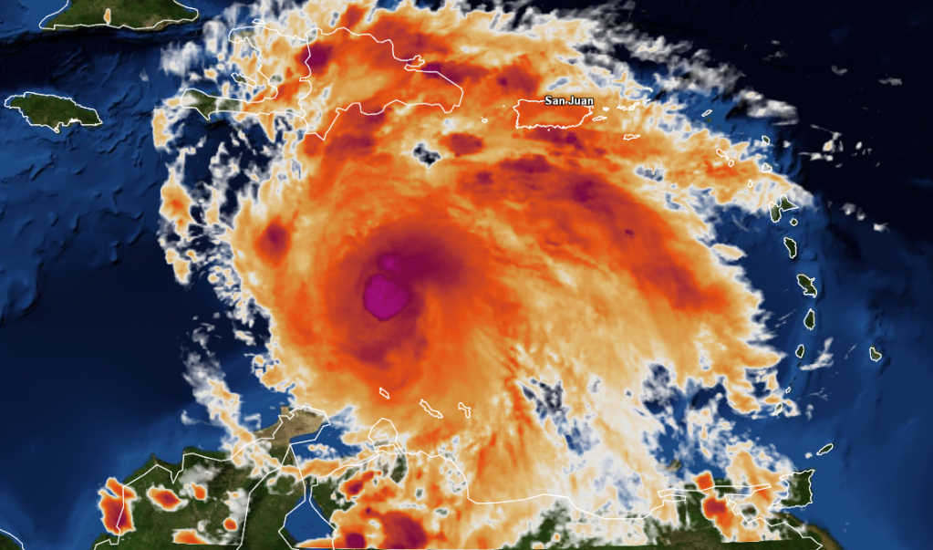
ATL: ERNESTO - Post-Tropical

Moderator: S2k Moderators

Message
Author
User avatar
KWT
Category 5
Category 5
Posts: 31415
Joined: Tue Aug 17, 2004 11:02 am
Location: UK!!!

Re: Re:

#2501 Postby KWT » Sat Aug 04, 2012 3:51 pm

Javlin wrote:
I do not know about that KWT?JB tweeted last night if my time frame is right it might die here for awhile and a few here were thinking the same but he sure has "kicked it up a notch" today.He seems to have his own envelope like he is a big boy making his own enviroment.


When I say in check, I mean it should be enough to stop it from bombing away, which I think is actually quite likely by the time it reaches the W.Caribbean (I think a 3-4 Yucatan landfall is very possible)

The NHC seem pretty sure that this system is going to be stronger come the next set of recon obs.
0 likes   
Personal Forecast Disclaimer:
The posts in this forum are NOT official forecast and should not be used as such. They are just the opinion of the poster and may or may not be backed by sound meteorological data. They are NOT endorsed by any professional institution or storm2k.org. For official information, please refer to the NHC and NWS products

User avatar
mcheer23
Professional-Met
Professional-Met
Posts: 437
Age: 32
Joined: Sun Jun 24, 2012 8:24 pm
Location: Sugar Land, Texas

#2502 Postby mcheer23 » Sat Aug 04, 2012 3:52 pm

If recon finds this storm near hurricane strength as the discussion indicates ..I would think that would change the track...
0 likes   

User avatar
Hurricane Alexis
Category 2
Category 2
Posts: 683
Age: 29
Joined: Thu Jun 14, 2012 7:59 pm
Location: Miami,Florida

Re:

#2503 Postby Hurricane Alexis » Sat Aug 04, 2012 3:53 pm

mcheer23 wrote:If recon finds this storm near hurricane strength as the discussion indicates ..I would think that would change the track...


Probably leaning more towards the GFDL and HWRF solutions if that verifies.
0 likes   
Personal Forecast Disclaimer:
The posts in this forum are NOT official forecast and should not be used as such. They are just the opinion of the poster and may or may not be backed by sound meteorological data. They are NOT endorsed by any professional institution or storm2k.org. For official information, please refer to the NHC and NWS products.

Shuriken

#2504 Postby Shuriken » Sat Aug 04, 2012 3:54 pm

Toss-up for the crowd (and tag your disclaimers):

Q. Assuming hurricane tomorrow, why in your opinion would or would not Ernesto become a major hurricane prior to the Yucatan?

The NHC as of 11am was forecasting Ernesto to become a hurricane sometime Sunday (i.e., 75mph in 36hrs), yet inexplicably increase only another 15mph (to 90mph) while thereafter traveling WNW across the breadth of the northwestern Caribbean (where the statistical track-record of already established systems "bombing" is quite high). They're basically keeping it a cat-1.

If Ernesto is a hurricane tomorrow and the models still aren't generating some numbers, the next met shifts are going to be in the uncomfortable position of having to disregard more and more of them for that real seat-of-the-pants flying sensation. :ggreen:
1100 AM AST SAT AUG 04 2012
<snip recon/current analysis>

AS INDICATED IN THE PREVIOUS ADVISORY...I DO NOT HAVE ANY REASONS TO
FORECAST WEAKENING AS SOME OF THE DYNAMICAL MODELS PREDICT...
INCLUDING THE HWRF AND THE GFDL. THE SHEAR IS LOW AHEAD OF THE
CYCLONE AND ERNESTO WILL MOVE OVER AN OCEAN WITH HIGHER HEAT
CONTENT. GIVEN SUCH CONDITIONS...THE OFFICIAL FORECAST CALLS FOR
ERNESTO TO BECOME A HURRICANE IN THE WESTERN CARIBBEAN AS SUGGESTED
BY THE SHIPS AND LGEM MODELS.

ERNESTO CONTINUES TO MOVE TOWARD THE WEST OR 280 DEGREES AT 16
KNOTS...EMBEDDED IN THE FLOW SOUTH OF THE SUBTROPICAL RIDGE. THIS
GENERAL TRACK IS EXPECTED TO CONTINUE FOR THE NEXT 24 TO 48 HOURS.
AFTER THAT...THE SUBTROPICAL HIGH IS FORECAST TO WEAKEN...RESULTING
IN ERNESTO TURNING MORE TOWARD THE WEST-NORTHWEST WITH A DECREASE
IN FORWARD SPEED. THE OFFICIAL FORECAST IS VERY CLOSE TO THE
SOLUTION OF MOST THE GLOBAL MODELS...BRINGING ERNESTO OVER THE
NORTHWESTERN CARIBBEAN AND ACROSS THE YUCATAN PENINSULA. AT THIS
TIME...THE NHC FORECAST DISREGARDS THE NORTHWARD TURN INDICATED BY
THE GFDL/HWRF MODEL PAIR.

FORECAST POSITIONS AND MAX WINDS

INIT 04/1500Z 14.4N 68.7W 45 KT 50 MPH
12H 05/0000Z 14.8N 71.2W 45 KT 50 MPH
24H 05/1200Z 15.5N 74.5W 50 KT 60 MPH
36H 06/0000Z 15.7N 77.5W 65 KT 75 MPH
48H 06/1200Z 16.5N 80.5W 70 KT 80 MPH
72H 07/1200Z 18.0N 84.0W 80 KT 90 MPH
96H 08/1200Z 19.5N 87.0W 70 KT 80 MPH
120H 09/1200Z 22.0N 90.5W 60 KT 70 MPH

FORECASTER AVILA

- - - - -

Image
Last edited by Shuriken on Sat Aug 04, 2012 4:01 pm, edited 3 times in total.
0 likes   

User avatar
Annie Oakley
Category 5
Category 5
Posts: 1103
Joined: Tue Jul 31, 2007 12:54 pm
Location: Texas

Re: ATL: ERNESTO - Tropical Storm

#2505 Postby Annie Oakley » Sat Aug 04, 2012 3:55 pm

Gusty.....thanks for that awesome graphic............
0 likes   

User avatar
KWT
Category 5
Category 5
Posts: 31415
Joined: Tue Aug 17, 2004 11:02 am
Location: UK!!!

Re: Re:

#2506 Postby KWT » Sat Aug 04, 2012 3:57 pm

Hurricane Alexis wrote:
mcheer23 wrote:If recon finds this storm near hurricane strength as the discussion indicates ..I would think that would change the track...


Probably leaning more towards the GFDL and HWRF solutions if that verifies.


It shouldn't make much of a difference in the near future but obviously a stronger system is more likely to latch onto any weakness that may open up. Whether or not the weakness is enough to scoop Ernesto up is another matter.
0 likes   
Personal Forecast Disclaimer:
The posts in this forum are NOT official forecast and should not be used as such. They are just the opinion of the poster and may or may not be backed by sound meteorological data. They are NOT endorsed by any professional institution or storm2k.org. For official information, please refer to the NHC and NWS products

User avatar
KWT
Category 5
Category 5
Posts: 31415
Joined: Tue Aug 17, 2004 11:02 am
Location: UK!!!

#2507 Postby KWT » Sat Aug 04, 2012 3:59 pm

Will recon increase if and when Ernesto becomes a hurricane?
0 likes   
Personal Forecast Disclaimer:
The posts in this forum are NOT official forecast and should not be used as such. They are just the opinion of the poster and may or may not be backed by sound meteorological data. They are NOT endorsed by any professional institution or storm2k.org. For official information, please refer to the NHC and NWS products

Shuriken

Re: ATL: ERNESTO - Tropical Storm

#2508 Postby Shuriken » Sat Aug 04, 2012 3:59 pm

Annie, if you liked that, take a peek at this: http://www.atmos.washington.edu/~ovens/ ... nhanced+24
0 likes   

User avatar
TwisterFanatic
Category 5
Category 5
Posts: 1041
Joined: Mon Jun 28, 2010 12:43 pm
Location: Sallisaw, Oklahoma

#2509 Postby TwisterFanatic » Sat Aug 04, 2012 4:04 pm

Agree with the NHC that 60MPH might very well be conservative. IMO we have a higher end Tropical Storm. Wouldn't be shocked to see RECON find minimum Hurricane force winds, but I wouldn't bet on it. Personally, I think this is a 70MPH TS.

Personal Forecast Disclaimer:
The posts in this forum are NOT official forecast and should not be used as such. They are just the opinion of the poster and may or may not be backed by sound meteorological data. They are NOT endorsed by any professional institution or storm2k.org. For official information, please refer to the NHC and NWS products.
0 likes   
Personal Forecast Disclaimer:
The posts in this forum are NOT official forecast and should not be used as such. They are just the opinion of the poster and may or may not be backed by sound meteorological data. They are NOT endorsed by any professional institution or storm2k.org. For official information, please refer to the NHC and NWS products.

User avatar
Portastorm
Storm2k Moderator
Storm2k Moderator
Posts: 9914
Age: 63
Joined: Fri Jul 11, 2003 9:16 am
Location: Round Rock, TX
Contact:

Re: ATL: ERNESTO - Tropical Storm

#2510 Postby Portastorm » Sat Aug 04, 2012 4:04 pm

Everyone PLEASE READ

I sent out this "friendly reminder" earlier and it seems I have to do it again:

During busy times like now, let's keep the several word posts to a minimum, shall we? We all don't need to know if you agree with another post. And we don't need to see multiple posts asking the same question. Ask yourself "is what about I'm to post of value to everyone?" If you have an honest question, great. Ask it.

We mods don't want to squash dialogue and posts and encourage open dialogue ... but let's be a little more intelligent and efficient when we have busy times like this, ok? A lot of people are here as members and even more as guests reading every post. You'd be surprised who is reading in this thread. Folks need information and don't always have a lot of time.

Thanks everyone for being mindful of this.
0 likes   
Any forecasts under my name are to be taken with a grain of salt. Get your best forecasts from the National Weather Service and National Hurricane Center.

User avatar
KWT
Category 5
Category 5
Posts: 31415
Joined: Tue Aug 17, 2004 11:02 am
Location: UK!!!

#2511 Postby KWT » Sat Aug 04, 2012 4:05 pm

If the NHC track was to come off then it'd certainly be an interesting end to next week for N.Mexico and S.Texas. Been abit of a hotspot over the last few years for systems.
0 likes   
Personal Forecast Disclaimer:
The posts in this forum are NOT official forecast and should not be used as such. They are just the opinion of the poster and may or may not be backed by sound meteorological data. They are NOT endorsed by any professional institution or storm2k.org. For official information, please refer to the NHC and NWS products

HurricaneAndrew92

Re: ATL: ERNESTO - Tropical Storm

#2512 Postby HurricaneAndrew92 » Sat Aug 04, 2012 4:06 pm

I'm betting on Ernie being a 70mph storm with recon.


Edit: From satellite appearance, Ernie may well be a hurricane now, but you can't judge a book by its cover.


*edited by sg to consolidate back to back posts a couple of minutes apart
0 likes   

User avatar
KWT
Category 5
Category 5
Posts: 31415
Joined: Tue Aug 17, 2004 11:02 am
Location: UK!!!

#2513 Postby KWT » Sat Aug 04, 2012 4:11 pm

Whilst I never like to pre-guess what recon will eventually show but I do think that recon will indeed show a strong storm. Convection isn't quite as deep as it has been but thats to be expected with D-min happening right now, and the fact that it is firing hot towers is suggestive of a strengthening system.
0 likes   
Personal Forecast Disclaimer:
The posts in this forum are NOT official forecast and should not be used as such. They are just the opinion of the poster and may or may not be backed by sound meteorological data. They are NOT endorsed by any professional institution or storm2k.org. For official information, please refer to the NHC and NWS products

RL3AO
Moderator-Pro Met
Moderator-Pro Met
Posts: 16308
Joined: Thu Jun 14, 2007 10:03 pm
Location: NC

Re: ATL: ERNESTO - Tropical Storm

#2514 Postby RL3AO » Sat Aug 04, 2012 4:15 pm

I think it will continue to slowly intensify and reach hurricane intensity in the next 24-36 hours. I do think the dry air and lack of convergence are going to hurt it some. I think it approach the Yucatan and make landfall near or south of Cancun as a strong cat 1/ weak cat 2. After that I'm not going to hazard a guess.

Also, I'm going to take a guess that recon finds a much weaker storm then some of you think. I bet they struggle to verify that 50kt intensity.


Personal Forecast Disclaimer:
The posts in this forum are NOT official forecast and should not be used as such. They are just the opinion of the poster and may or may not be backed by sound meteorological data. They are NOT endorsed by any professional institution or storm2k.org. For official information, please refer to the NHC and NWS products.
0 likes   

User avatar
Hammy
Category 5
Category 5
Posts: 5849
Age: 42
Joined: Fri May 25, 2012 5:25 pm
Contact:

#2515 Postby Hammy » Sat Aug 04, 2012 4:16 pm

I'm doubting its strengthened much, maybe 65mph or still at 60mph--the inflow still seems a bit weak on the southern end
0 likes   
The above post is not official and should not be used as such. It is the opinion of the poster and may or may not be backed by sound meteorological data. It is not endorsed by any professional institution or storm2k.org. For official information, please refer to the NHC and NWS products.

User avatar
Gustywind
Category 5
Category 5
Posts: 12334
Joined: Mon Sep 03, 2007 7:29 am
Location: Baie-Mahault, GUADELOUPE

#2516 Postby Gustywind » Sat Aug 04, 2012 4:16 pm

For those who are interrested, here is a complete and full summary of Ernesto (who has spared Martinica :!). In terms of rainfall, Guadeloupe received much more water due to some outers bands reaching the butterfly island, while Martinica experienced strong winds and gustywinds. Very minors damages have occured and that's the good news. Will the storms continue to spared us in the Lesser Antilles? :all the season? is another story :oops: :roll: . Let's wait and see enjoying each day with joy, happiness and... :sun:

Regards

Gustywind

WEATHER

Ernesto spared Martinique


C.R.-V. France-Antilles Martinique 04.08.2012

:rarrow: http://www.microsofttranslator.com/bv.a ... 168618.php

The storm tropical Ernesto, who had pushed Weather France Martinica in orange vigilance, went more South than expected. Result: threat lifted, only light injuries and very little damage.
The forecast announced 100 to 150 mm of precipitation in some places. Yesterday afternoon, accumulations of rain remained low: between 10 and 30 mm, locally 40 mm on the terrain of the North. The wind would blow up to 150 km/h. The average was around 70 kph yesterday afternoon, with gusts to 110 km/h on the mornes of the northern side of the island. The sea would be very rough, reaching major heights. Maximum hollow reached 5 meters in Atlantic and channels, not more than one metre of the side Caribbean.
All these data have enabled weather France to lift the orange vigilance from 16 pm yesterday afternoon, leaving her in yellow because of the heavy rains which were expected last night. In the aftermath, the prefecture lifted its orange alert, also repositioning the cursor to yellow, "stay alert", because the same rainfall. This morning, Ernesto must be that a (bad) memory for the island. Fortunately for us, its trajectory has changed, more to the South, and has moved away in the Caribbean Sea. Weather France had planned it back but the winds were not strong enough to ensure that these forecasts are realized. Today, weather will improve throughout the day. Will as often after a hurricane, the sun will shine in the afternoon, after very limited showers in early morning rain. Prefecture nevertheless asked to remain vigilant, as long as the phenomenon is not finally ended.


DEPRECATED SWIMMING

These weather conditions did not bring major damage. The most important is a lightweight wounded at le Lorrain, electrified after attempting to manipulate electrical wires hidden under a tree fell on the pavement. In total, the prefecture has identified 20 interventions, whose many falls of trees, especially in the morning and essentially due to the wind. It is the Atlantic part of the island who has been the most concerned.

Finally, it is noted that the regional health agency (ARS) discourages swimming at sea and in the rivers, to the return to usual transparency of water whose quality could be affected by Ernesto.

-A thousand of persons deprived of electricity

Yesterday trees falls have achieved several electrical cables. Consequence: a thousand of customers private power, the vast majority (approximately 800) to the François and le Lorrain, the rest to le Morne-Vert. Should the current return early evening to the François and le Lorrain, it seemed a little longer for the people in le Morne-Vert, because the cable repair is located in a ravine. To cut dragged despite many officers mobilized, generators were planned.

Finally, the direction of EDF, and the prefecture, said that it is forbidden to approach and touch electrical cables to the ground. The only thing to do is to call EDF.


-Express of the Islands: the rotation resumed this morning

Ticketing on the Express of the Islands was not stormed yesterday, it is rather by phone that the cancellations were managed with passengers

It was not the crowd yesterday morning at the pier on the Express of the Islands. And for cause, the tropical storm would render impossible the departure for Saint Lucia. This is what happened, and for all sailings planned yesterday. Among the people who had moved, in the hope to go still, some expressed their discontent, more by desperation.

In these cases, the Express of the Islands is to allow passengers wishing a place for a later departure, subject to availability. Those who want to be refunded may, but with a penalty because the cancellation is not the responsibility of the company. Yesterday late in the day, customer service addressed to put its passengers remained in dock.

If the weather does not deteriorated last night, which was expected, rotations go well resume this morning, with additional hours.

To take knowledge, visit internet company (http://www.express-des-iles.com), updated in real time.
0 likes   

User avatar
AJC3
Admin
Admin
Posts: 4004
Age: 61
Joined: Tue Aug 31, 2004 7:04 pm
Location: Ballston Spa, New York
Contact:

Re: ATL: ERNESTO - Tropical Storm

#2517 Postby AJC3 » Sat Aug 04, 2012 4:20 pm

HurricaneAndrew92 wrote:From satellite appearance, Ernie may well be a hurricane now, but you can't judge a book by its cover.


None of the satellite intensity estimates suggest this is the case. Neither does the microwave presentation.
0 likes   

User avatar
brunota2003
S2K Supporter
S2K Supporter
Posts: 9476
Age: 34
Joined: Sat Jul 30, 2005 9:56 pm
Location: Stanton, KY...formerly Havelock, NC
Contact:

#2518 Postby brunota2003 » Sat Aug 04, 2012 4:25 pm

If you have a guess as to what Recon will find during their trip through Ernesto...then vote here:
viewtopic.php?f=25&t=113247

NOTE: This is the max wind speed that recon will find *at FLIGHT level* the entire mission! Not the first pass!

Post your guesses over there, so that we don't have 10 pages filled up on this thread of what you think they'll find :lol:

Mods: Can you set the poll to end at 7 pm? It only gave me a day option.
Last edited by brunota2003 on Sat Aug 04, 2012 4:27 pm, edited 1 time in total.
0 likes   
Just a small town southern boy helping other humans.

User avatar
Dave
Retired Staff
Retired Staff
Posts: 13442
Age: 74
Joined: Tue Aug 01, 2006 3:57 pm
Location: Milan Indiana
Contact:

Re:

#2519 Postby Dave » Sat Aug 04, 2012 4:25 pm

KWT wrote:Will recon increase if and when Ernesto becomes a hurricane?


I'm sure it will KWT. Because of that low off of Florida yesterday the schedules really got mixed up. Should be a better tcpod out tomorrow.
0 likes   

User avatar
cycloneye
Admin
Admin
Posts: 145862
Age: 69
Joined: Thu Oct 10, 2002 10:54 am
Location: San Juan, Puerto Rico

Re: ATL: ERNESTO - Tropical Storm

#2520 Postby cycloneye » Sat Aug 04, 2012 4:27 pm

The outflow is turning very good.

Image
0 likes   
Visit the Caribbean-Central America Weather Thread where you can find at first post web cams,radars
and observations from Caribbean basin members Click Here


Return to “2012”

Who is online

Users browsing this forum: No registered users and 4 guests