Euro vs. GFS ... still to be decided. The wait continues. It will be interesting to see what the NHC does with the cone at 5 am. Probably a nudge to the west. Big question will be what happens with NOLA ... is it in or out of the cone?
A big thank you to all who posted the model runs.
ATL: ISAAC - Models
Moderator: S2k Moderators
-
StormClouds63
- Category 2

- Posts: 583
- Age: 62
- Joined: Tue May 13, 2008 11:56 am
- Location: Southwest Louisiana
Re: ATL: ISAAC - Models
0 likes
-
timmeister

- Tropical Storm

- Posts: 191
- Age: 63
- Joined: Thu Jan 06, 2011 11:17 am
- Location: Hattiesburg, MS
Re: ATL: ISAAC - Models

0 likes
Personal Forecast Disclaimer:
The posts in this forum are NOT official forecast and should not be used as such. They are just the opinion of the poster and may or may not be backed by sound meteorological data. They are NOT endorsed by any professional institution or storm2k.org. For official information, please refer to the NHC and NWS products.
The posts in this forum are NOT official forecast and should not be used as such. They are just the opinion of the poster and may or may not be backed by sound meteorological data. They are NOT endorsed by any professional institution or storm2k.org. For official information, please refer to the NHC and NWS products.
-
StormClouds63
- Category 2
- Posts: 583
- Age: 62
- Joined: Tue May 13, 2008 11:56 am
- Location: Southwest Louisiana
Re: ATL: ISAAC - Models
Euro vs. GFS ... still to be decided. The wait continues. It will be interesting to see what the NHC does with the cone at 5 am. Probably a nudge to the west. Big question will be what happens with NOLA ... is it in or out of the cone?
A big thank you to all who posted the model runs.
A big thank you to all who posted the model runs.
0 likes
-
SunnyThoughts
- Category 5

- Posts: 2263
- Joined: Wed Jul 09, 2003 12:42 pm
- Location: Pensacola, Florida
Re: Re:
smw1981 wrote:SunnyThoughts wrote:So it hasn't really moved between hour 72 and hour 84? sitting right there on the Ala/Fla coast?
That could be REALLY bad for both of us Sunny.. At least 12 hours of water piling up in y'alls bays.. no good.
yeah smw, just sitting there and continuing to pump water up into mobile bay, as well as our bay here. Surely if it sits like that for longer than 8 hours or so...whatever intensity it happens to be will surely start to diminish. I would think/ and hope...but that won't help the fact that the water will be piling up.
0 likes
-
timmeister
- Tropical Storm
- Posts: 191
- Age: 63
- Joined: Thu Jan 06, 2011 11:17 am
- Location: Hattiesburg, MS
Re: ATL: ISAAC - Models

0 likes
Personal Forecast Disclaimer:
The posts in this forum are NOT official forecast and should not be used as such. They are just the opinion of the poster and may or may not be backed by sound meteorological data. They are NOT endorsed by any professional institution or storm2k.org. For official information, please refer to the NHC and NWS products.
The posts in this forum are NOT official forecast and should not be used as such. They are just the opinion of the poster and may or may not be backed by sound meteorological data. They are NOT endorsed by any professional institution or storm2k.org. For official information, please refer to the NHC and NWS products.
-
TwisterFanatic

- Category 5
- Posts: 1041
- Joined: Mon Jun 28, 2010 12:43 pm
- Location: Sallisaw, Oklahoma
Re: ATL: ISAAC - Models
StormClouds63 wrote:Euro vs. GFS ... still to be decided. The wait continues. It will be interesting to see what the NHC does with the cone at 5 am. Probably a nudge to the west. Big question will be what happens with NOLA ... is it in or out of the cone?
A big thank you to all who posted the model runs.
NOLA definitely in the cone, IMO
0 likes
Personal Forecast Disclaimer:
The posts in this forum are NOT official forecast and should not be used as such. They are just the opinion of the poster and may or may not be backed by sound meteorological data. They are NOT endorsed by any professional institution or storm2k.org. For official information, please refer to the NHC and NWS products.
The posts in this forum are NOT official forecast and should not be used as such. They are just the opinion of the poster and may or may not be backed by sound meteorological data. They are NOT endorsed by any professional institution or storm2k.org. For official information, please refer to the NHC and NWS products.


-
Hyperstorm

- Category 5
- Posts: 1500
- Joined: Sun Sep 07, 2003 3:48 am
- Location: Ocala, FL
Re: ATL: ISAAC - Models
The following is NOT an official forecast. Refer to the NHC for official information.
I see a BIG shift in the forecast track AND cone at 5 am. Should be in the middle of the GFS and EURO....That would be a point in Mississippi and Alabama.
I see a BIG shift in the forecast track AND cone at 5 am. Should be in the middle of the GFS and EURO....That would be a point in Mississippi and Alabama.
0 likes
-
SunnyThoughts
- Category 5
- Posts: 2263
- Joined: Wed Jul 09, 2003 12:42 pm
- Location: Pensacola, Florida
-
Hurricane Alexis

- Category 2
- Posts: 683
- Age: 29
- Joined: Thu Jun 14, 2012 7:59 pm
- Location: Miami,Florida
Re: ATL: ISAAC - Models
SFLcane wrote:00z GFDL into southeastern florida in this run.
The GFDL has been going back and forth in intensity and track.
0 likes
Personal Forecast Disclaimer:
The posts in this forum are NOT official forecast and should not be used as such. They are just the opinion of the poster and may or may not be backed by sound meteorological data. They are NOT endorsed by any professional institution or storm2k.org. For official information, please refer to the NHC and NWS products.
The posts in this forum are NOT official forecast and should not be used as such. They are just the opinion of the poster and may or may not be backed by sound meteorological data. They are NOT endorsed by any professional institution or storm2k.org. For official information, please refer to the NHC and NWS products.
-
Kingarabian

- S2K Supporter

- Posts: 16351
- Joined: Sat Aug 08, 2009 3:06 am
- Location: Honolulu, Hawaii


Re: ATL: ISAAC - Models
BigB0882 wrote:bella_may wrote:Euro done a much better job with this run than the gfs did IMO. And i'm a fan of the gfs
Would you share why you think that? I am trying to learn all I can.
It initialized much better and it done a good job with the ridge over colorado. again, jmo though
0 likes

Re: ATL: ISAAC - Models
So 96 Kt wind would be what? 110-115 mph?
0 likes
Personal Forecast Disclaimer:
The posts in this forum are NOT official forecast and should not be used as such. They are just the opinion of the poster and may or may not be backed by sound meteorological data. They are NOT endorsed by any professional institution or storm2k.org. For official information, please refer to the NHC and NWS products.
The posts in this forum are NOT official forecast and should not be used as such. They are just the opinion of the poster and may or may not be backed by sound meteorological data. They are NOT endorsed by any professional institution or storm2k.org. For official information, please refer to the NHC and NWS products.
-
TwisterFanatic
- Category 5
- Posts: 1041
- Joined: Mon Jun 28, 2010 12:43 pm
- Location: Sallisaw, Oklahoma
While we didn't get a consensus tonight, I think tonight's EURO could've start the trend towards one. Again, Just my opinion.
0 likes
Personal Forecast Disclaimer:
The posts in this forum are NOT official forecast and should not be used as such. They are just the opinion of the poster and may or may not be backed by sound meteorological data. They are NOT endorsed by any professional institution or storm2k.org. For official information, please refer to the NHC and NWS products.
The posts in this forum are NOT official forecast and should not be used as such. They are just the opinion of the poster and may or may not be backed by sound meteorological data. They are NOT endorsed by any professional institution or storm2k.org. For official information, please refer to the NHC and NWS products.

Re: ATL: ISAAC - Models
Late night round up then bed:
east to west...
0z UKmet panama city
0z gfdl destin
0z euro gulf shores
0z gfs/hwrf new orleans via Buras/Houma
0z Canadian Houma to baton rouge
east to west...
0z UKmet panama city
0z gfdl destin
0z euro gulf shores
0z gfs/hwrf new orleans via Buras/Houma
0z Canadian Houma to baton rouge
0 likes
-
brunota2003

- S2K Supporter
- Posts: 9476
- Age: 35
- Joined: Sat Jul 30, 2005 9:56 pm
- Location: Stanton, KY...formerly Havelock, NC
- Contact:
-
Kingarabian
- S2K Supporter
- Posts: 16351
- Joined: Sat Aug 08, 2009 3:06 am
- Location: Honolulu, Hawaii
Re: ATL: ISAAC - Models
What is the GFDI?
0 likes
Personal Forecast Disclaimer:
The posts in this forum are NOT official forecast and should not be used as such. They are just the opinion of the poster and may or may not be backed by sound meteorological data. They are NOT endorsed by any professional institution or storm2k.org. For official information, please refer to the NHC and NWS products.
The posts in this forum are NOT official forecast and should not be used as such. They are just the opinion of the poster and may or may not be backed by sound meteorological data. They are NOT endorsed by any professional institution or storm2k.org. For official information, please refer to the NHC and NWS products.
-
Rgv20

- S2K Supporter
- Posts: 2466
- Age: 39
- Joined: Wed Jan 05, 2011 5:42 pm
- Location: Edinburg/McAllen Tx
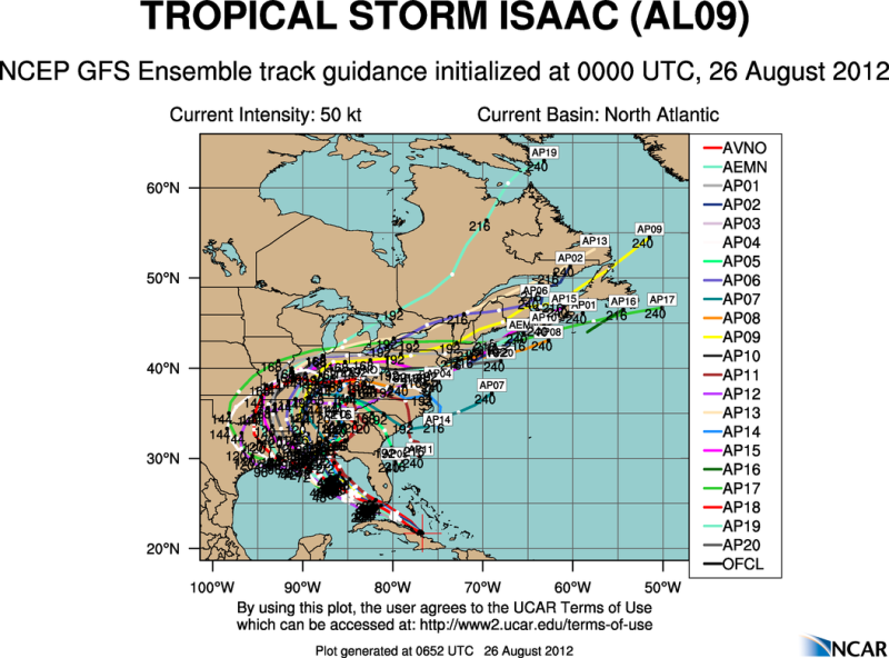
0zGFS Ensemble Tracks..
0 likes
The following post is NOT an official forecast and should not be used as such. It is just the opinion of the poster and may or may not be backed by sound meteorological data. It is NOT endorsed by any professional institution including storm2k.org For Official Information please refer to the NHC and NWS products.
-
timmeister
- Tropical Storm
- Posts: 191
- Age: 63
- Joined: Thu Jan 06, 2011 11:17 am
- Location: Hattiesburg, MS
Re: ATL: ISAAC - Models
Blinhart wrote:What is the GFDI?
GFDL is a computer model
A model developed specifically for tropical systems, this model is nested as part of the GFS global model, with a focus on the Atlantic and Pacific basins. The GFDL has become the most reliable model in recent years, with its average error the least of all models. It additionally has performed well with individual storms, often as either the most accurate or second-most accurate model with individual storms.
0 likes
Personal Forecast Disclaimer:
The posts in this forum are NOT official forecast and should not be used as such. They are just the opinion of the poster and may or may not be backed by sound meteorological data. They are NOT endorsed by any professional institution or storm2k.org. For official information, please refer to the NHC and NWS products.
The posts in this forum are NOT official forecast and should not be used as such. They are just the opinion of the poster and may or may not be backed by sound meteorological data. They are NOT endorsed by any professional institution or storm2k.org. For official information, please refer to the NHC and NWS products.
Who is online
Users browsing this forum: No registered users and 31 guests