ATL: ISAAC - Models
Moderator: S2k Moderators

Re: ATL: ISAAC - Models
But the TWC didn't have GFDL they had GFDI.
0 likes
Personal Forecast Disclaimer:
The posts in this forum are NOT official forecast and should not be used as such. They are just the opinion of the poster and may or may not be backed by sound meteorological data. They are NOT endorsed by any professional institution or storm2k.org. For official information, please refer to the NHC and NWS products.
The posts in this forum are NOT official forecast and should not be used as such. They are just the opinion of the poster and may or may not be backed by sound meteorological data. They are NOT endorsed by any professional institution or storm2k.org. For official information, please refer to the NHC and NWS products.
-
Kingarabian

- S2K Supporter

- Posts: 16351
- Joined: Sat Aug 08, 2009 3:06 am
- Location: Honolulu, Hawaii
Re: ATL: ISAAC - Models
Blinhart wrote:But the TWC didn't have GFDL they had GFDI.
Same thang.
0 likes
RIP Kobe Bryant
-
TwisterFanatic

- Category 5

- Posts: 1041
- Joined: Mon Jun 28, 2010 12:43 pm
- Location: Sallisaw, Oklahoma
Re:
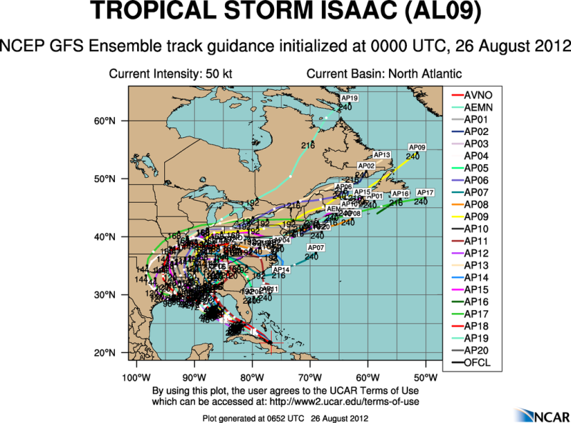
Rgv20 wrote:0zGFS Ensemble Tracks..
http://i61.photobucket.com/albums/h62/c ... ck_gfs.png
Looks to be very tightly clustered.
0 likes
Personal Forecast Disclaimer:
The posts in this forum are NOT official forecast and should not be used as such. They are just the opinion of the poster and may or may not be backed by sound meteorological data. They are NOT endorsed by any professional institution or storm2k.org. For official information, please refer to the NHC and NWS products.
The posts in this forum are NOT official forecast and should not be used as such. They are just the opinion of the poster and may or may not be backed by sound meteorological data. They are NOT endorsed by any professional institution or storm2k.org. For official information, please refer to the NHC and NWS products.
-
Rgv20

- S2K Supporter
- Posts: 2466
- Age: 39
- Joined: Wed Jan 05, 2011 5:42 pm
- Location: Edinburg/McAllen Tx
Re: ATL: ISAAC - Models
Blinhart wrote:What is the GFDI?
"Previous cycle GFDL, adjusted"
Here is a link for the description of the various models the NHC uses...http://www.nhc.noaa.gov/modelsummary.shtml
0 likes
The following post is NOT an official forecast and should not be used as such. It is just the opinion of the poster and may or may not be backed by sound meteorological data. It is NOT endorsed by any professional institution including storm2k.org For Official Information please refer to the NHC and NWS products.
Re: ATL: ISAAC - Models
Yeah looks very tightly clustered all over Louisiana. Can hardly see any of Louisiana with all those marks. But I think I saw a couple actually go near Beaumont.
0 likes
Personal Forecast Disclaimer:
The posts in this forum are NOT official forecast and should not be used as such. They are just the opinion of the poster and may or may not be backed by sound meteorological data. They are NOT endorsed by any professional institution or storm2k.org. For official information, please refer to the NHC and NWS products.
The posts in this forum are NOT official forecast and should not be used as such. They are just the opinion of the poster and may or may not be backed by sound meteorological data. They are NOT endorsed by any professional institution or storm2k.org. For official information, please refer to the NHC and NWS products.
-
OzCycloneChaserTrav

- Tropical Low

- Posts: 30
- Age: 34
- Joined: Thu Aug 23, 2012 2:35 am
- Location: Townsville, Queensland Australia
- Contact:
Re:
brunota2003 wrote:95 knots is 110 mph, right on the threshold.
Sustained I'm guessing? That's 178kmhr ....
0 likes
Oz Cyclone Chasers ( Australian Cyclone Chasers )
Tropical Cyclone Ului Category 3 2010
Tropical Cyclone Anthony Category 2 2011
Tropical Cyclone Yasi Category 5 2011
Tropical Cyclone Lua Category 4 2012
Tropical Cyclone Dylan Category 2 2014
Tropical Cyclone Ita Category 5 2014
Tropical Cyclone Ului Category 3 2010
Tropical Cyclone Anthony Category 2 2011
Tropical Cyclone Yasi Category 5 2011
Tropical Cyclone Lua Category 4 2012
Tropical Cyclone Dylan Category 2 2014
Tropical Cyclone Ita Category 5 2014
-
HouTXmetro

- Category 5
- Posts: 3949
- Joined: Sun Jun 13, 2004 6:00 pm
- Location: District of Columbia, USA
Re: ATL: ISAAC - Models
WTH is going on? I leave the board virtually all day and log on tonight and see the GFS with a dramatic shift west to Louisiana. Not to mention several GFS ensembles headed into SE Texas? What changed throughout the last 18 or so hours. I just new the FL panhandle/AL/MS coast was a done deal.
0 likes
[Disclaimer: My Amateur Opinion, please defer to your local authorities or the NHC for Guidance.]
-
brunota2003

- S2K Supporter
- Posts: 9476
- Age: 35
- Joined: Sat Jul 30, 2005 9:56 pm
- Location: Stanton, KY...formerly Havelock, NC
- Contact:
Re: Re:
OzCycloneChaserTrav wrote:brunota2003 wrote:95 knots is 110 mph, right on the threshold.
Sustained I'm guessing? That's 178kmhr ....
Yep, that would be sustained.
0 likes
Just a small town southern boy helping other humans.
-
Hurricane Cheese

- Category 1

- Posts: 365
- Joined: Thu Aug 12, 2004 12:40 am
- Location: Green Bay, WI (UWGB Earth Science Alum)
Re: ATL: ISAAC - Models
The $64,000 question I have tonight is what are the emergency managers in NOLA going to do? The ensembles place them squarely in the cone, and it takes 72 hours to induce a mandatory evacuation of NOLA. If they don't do it and this does indeed become a major hurricane approaching from SE...then....
0 likes
"If we are afraid to be different...how can we make a difference in the world?"
- Rev. John I. Jenkins C.S.C, President, University of Notre Dame
- Rev. John I. Jenkins C.S.C, President, University of Notre Dame

Re: ATL: ISAAC - Models
Oh, I have been telling you guys for days now....but noooo....I get publicly flogged, dis-embowled and quartered..... 
west is the only way....it will not miss right...god speed to those who are in Isass'a path....
JMO....add 2K disclamier.....I just got back from having 9 vodak and cranberries...
west is the only way....it will not miss right...god speed to those who are in Isass'a path....
JMO....add 2K disclamier.....I just got back from having 9 vodak and cranberries...
0 likes

Wow some of the models really are bullish, quite a few are very close to major status now!
0 likes
Personal Forecast Disclaimer:
The posts in this forum are NOT official forecast and should not be used as such. They are just the opinion of the poster and may or may not be backed by sound meteorological data. They are NOT endorsed by any professional institution or storm2k.org. For official information, please refer to the NHC and NWS products
The posts in this forum are NOT official forecast and should not be used as such. They are just the opinion of the poster and may or may not be backed by sound meteorological data. They are NOT endorsed by any professional institution or storm2k.org. For official information, please refer to the NHC and NWS products
-
Katrina New Orleans
- Tropical Wave

- Posts: 1
- Joined: Thu May 26, 2011 4:37 pm
Re: ATL: ISAAC - Models
Hurricane Cheese wrote:The $64,000 question I have tonight is what are the emergency managers in NOLA going to do? The ensembles place them squarely in the cone, and it takes 72 hours to induce a mandatory evacuation of NOLA. If they don't do it and this does indeed become a major hurricane approaching from SE...then....
Well I live on the westbank of New Orleans so I can answer that one for you. What will we do evacuate evacuate evacuate!!!!!!! I believe we will get started in the morning no one wants to be responsible for lives after what happen with Katrina!
0 likes
Re: ATL: ISAAC - Models
I imagine emergency officials go off of the NHC official forecast and not the Isaacs Model thread here...let's see how the experts interpret all the varying data. Evacuations are based off of official NHC forecasts and guidance/discussion. No doubt there is heightened concern when New Orleans is involved based on the time to evacuate, but let's see what the 5am forecast says
Katrina New Orleans wrote:Hurricane Cheese wrote:The $64,000 question I have tonight is what are the emergency managers in NOLA going to do? The ensembles place them squarely in the cone, and it takes 72 hours to induce a mandatory evacuation of NOLA. If they don't do it and this does indeed become a major hurricane approaching from SE...then....
Well I live on the westbank of New Orleans so I can answer that one for you. What will we do evacuate evacuate evacuate!!!!!!! I believe we will get started in the morning no one wants to be responsible for lives after what happen with Katrina!
0 likes

-
HurryKane

- Category 5
- Posts: 1941
- Joined: Sun Sep 12, 2004 8:08 pm
- Location: Diamondhead, Mississippi
Re: ATL: ISAAC - Models
jinftl wrote:I imagine emergency officials go off of the NHC official forecast and not the Isaacs Model thread here...let's see how the experts interpret all the varying data. Evacuations are based off of official NHC forecasts and guidance/discussion. No doubt there is heightened concern when New Orleans is involved based on the time to evacuate, but let's see what the 5am forecast saysKatrina New Orleans wrote:Hurricane Cheese wrote:The $64,000 question I have tonight is what are the emergency managers in NOLA going to do? The ensembles place them squarely in the cone, and it takes 72 hours to induce a mandatory evacuation of NOLA. If they don't do it and this does indeed become a major hurricane approaching from SE...then....
Well I live on the westbank of New Orleans so I can answer that one for you. What will we do evacuate evacuate evacuate!!!!!!! I believe we will get started in the morning no one wants to be responsible for lives after what happen with Katrina!
Now that the 5 AM is out:
WWLTV and WDSU (NOLA) are running paid advertisements, no info.
wwltv.com is sounding the alarm about the new NHC path.Wdsu.com says Jefferson/Plaquemines parishes are in high alert.
nola.com has an article buried somewhere other than the front page, filed at 11 pm last night.
WLOX (Biloxi) and the Mobile station are running paid programming with small bugs showing the hurricane watch.
I fear that with it being a Sunday, many will be caught off guard with large forecast shifts occurring on a weekend as happened with Katrina.
(as of 0500 CDT WDSU now has a big red ticker at the top of the screen about Isaac/watches)
Last edited by HurryKane on Sun Aug 26, 2012 5:04 am, edited 3 times in total.
0 likes
-
stormreader
Re: ATL: ISAAC - Models
Looking real hard at the latest GFS. Yesterday afternoon with GFS landfall projected near New Orleans and extreme SE La, I thought that we might expect Isaac to come ashore even a little west of that near Grand Isle in SE La. Have to think now that latest GFS is even more telling, with a complete miss by the trough to the north. Anywhere now along central La coast seems more probable with a slower storm as we approach landfall. Somewhere near Atchafalaya Bay and Morgan City looks good. Do think it will have enough N component to move solidly inland near there and not furthe west near Cameron.
The following post is NOT an official forecast and should not be used as such. It is just the opinion of the poster and may or may not be backed by sound meteorological data. It is NOT endorsed by any professional institution including storm2k.org. For Official Information please refer to the NHC and NWS products.
0 likes

Re: ATL: ISAAC - Models
Looking at GFS 42hrs, a strong ULL will be anchored NE of Hispaniola.
This should create a good outflow channel across the north and east quads of Isaac.
http://moe.met.fsu.edu/cgi-bin/gfstc2.c ... =Animation
Anti-cyclone still forecast to be over Isaac which aids stretching his vorticity column vertically and helping him to spin up.
http://moe.met.fsu.edu/cgi-bin/gfstc2.c ... =Animation
Looks like he may have to contend with a pocket of bounday-layer dry air to his west though.
http://moe.met.fsu.edu/cgi-bin/gfstc2.c ... =Animation
Any shift west in his track at that time brings him closer to the Loop-Current Eddy at 26N 89W
http://rammb.cira.colostate.edu/product ... 260000.GIF
NAM is forecasting CAPE = 2000 at that time with no CIN.
http://www.twisterdata.com/index.php?pr ... hive=false
http://www.twisterdata.com/index.php?pr ... ding.y=542
0 likes

Re: ATL: ISAAC - Models
You are exactly right HurryKane. Saw on FB a guy post he was headed out fishing. WTH. MODELS SHIFTING WEST STILL WILL PUT US IN A BAD SPOT !! 
0 likes
-
CYCLONE MIKE
- Category 5
- Posts: 2183
- Joined: Tue Aug 31, 2004 6:04 pm
- Location: Gonzales, LA
Re: ATL: ISAAC - Models
Guys posted this in other thread but will put in here as well. The reason N.O. is not starting evacs is because they are not under watch. As soon as watch is issued it sets things motion. Forecast is too low right now. We have all seen how fast models can change.
0 likes
Who is online
Users browsing this forum: No registered users and 13 guests