
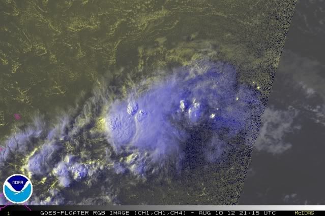
The area 7 is passing through now has that dry stable air cloud pattern look and the circulation looks more elongated to me than it did yesterday. If I didn't know better I could mistake it for a fast moving high amplitude wave..
Shear coming off South America is the norm in the eastern and central Caribbean and that often keeps weak systems from spinning up.
ATL: HELENE - Post-Tropical
Moderator: S2k Moderators
Re: ATL: SEVEN - Tropical Depression
This has west Caribbean written all over it. Suspended animation through the east Caribbean hostile zone, then development.
A developed LLC is the hard part over convection. TD7 obviously has that.
The posts in this forum are NOT official forecast and should not be used as such. They are just the opinion of the poster and may or may not be backed by sound meteorological data. They are NOT endorsed by any professional institution or storm2k.org. For official information, please refer to the NHC and NWS products.
0 likes
-
Extratropical94

- Professional-Met

- Posts: 3545
- Age: 31
- Joined: Wed Oct 20, 2010 6:36 am
- Location: Hamburg, Germany
- Contact:
18Z BT update:
AL, 07, 2012081018, , BEST, 0, 137N, 509W, 30, 1009, TD
AL, 07, 2012081018, , BEST, 0, 137N, 509W, 30, 1009, TD
0 likes
54° 11' 59'' N, 9° 9' 20'' E
Boomer Sooner!
Go Broncos! Go Cards!
Clinching counties, one at a time: https://mob-rule.com/user-gifs/USA/xtrp94.gif
- Daniel
Boomer Sooner!
Go Broncos! Go Cards!
Clinching counties, one at a time: https://mob-rule.com/user-gifs/USA/xtrp94.gif
- Daniel
-
cheezyWXguy

- Category 5

- Posts: 6282
- Joined: Mon Feb 13, 2006 12:29 am
- Location: Dallas, TX
Re: ATL: SEVEN - Tropical Depression
Sanibel wrote:This has west Caribbean written all over it. Suspended animation through the east Caribbean hostile zone, then development.
A developed LLC is the hard part over convection. TD7 obviously has that.
The posts in this forum are NOT official forecast and should not be used as such. They are just the opinion of the poster and may or may not be backed by sound meteorological data. They are NOT endorsed by any professional institution or storm2k.org. For official information, please refer to the NHC and NWS products.
yes thats true, but sustaining such a well established LLC isn't likely without persistent convection. Im still not sure what to think on this one, but I do believe that if it can survive through the eastern caribbean, or at least maintain some sort of low level surface feature, then it may have better chances of strengthening or regeneration in the western caribbean. The idea of middle US ridge breaking down next week does put a big question mark in how this gulf ridge may evolve over the next week, and we may be looking at an entirely different pattern at that time than we currently believe.
0 likes
-
Weatherfreak000
Re: ATL: SEVEN - Tropical Depression
Moving really quickly may be fairly helpful for TD 7 it looks like it might just go ahead and outrace the negative environment. ROCK is right can never count a storm out, models seem keen to kill off alot of storms this season, and seeing as how they re-develop later near the GOM it may get very interesting if TD 7 makes it.
0 likes
-
cycloneye

- Admin

- Posts: 149493
- Age: 69
- Joined: Thu Oct 10, 2002 10:54 am
- Location: San Juan, Puerto Rico
Re: ATL: SEVEN - Advisories
TROPICAL DEPRESSION SEVEN ADVISORY NUMBER 5
NWS NATIONAL HURRICANE CENTER MIAMI FL AL072012
500 PM AST FRI AUG 10 2012
...TROPICAL STORM WATCHES ISSUED FOR PORTIONS OF THE LESSER
ANTILLES...
SUMMARY OF 500 PM AST...2100 UTC...INFORMATION
----------------------------------------------
LOCATION...13.7N 51.9W
ABOUT 510 MI...825 KM E OF BARBADOS
MAXIMUM SUSTAINED WINDS...35 MPH...55 KM/H
PRESENT MOVEMENT...W OR 270 DEGREES AT 24 MPH...39 KM/H
MINIMUM CENTRAL PRESSURE...1009 MB...29.80 INCHES
WATCHES AND WARNINGS
--------------------
CHANGES WITH THIS ADVISORY...
THE GOVERNMENT OF FRANCE HAS ISSUED A TROPICAL STORM WATCH FOR
GUADELOUPE AND MARTINIQUE.
THE GOVERNMENT OF BARBADOS HAS ISSUED A TROPICAL STORM WATCH FOR
BARBADOS...ST. VINCENT AND THE GRENADINES...AND DOMINICA.
THE GOVERNMENT OF ST. LUCIA HAS ISSUED A TROPICAL STORM WATCH FOR
ST. LUCIA.
SUMMARY OF WATCHES AND WARNINGS IN EFFECT...
A TROPICAL STORM WATCH IS IN EFFECT FOR...
* GUADELOUPE AND MARTINIQUE
* DOMINICA
* ST. LUCIA
* BARBADOS
* ST. VINCENT AND THE GRENADINES
A TROPICAL STORM WATCH MEANS THAT TROPICAL STORM CONDITIONS ARE
POSSIBLE WITHIN THE WATCH AREA...IN THIS CASE IN 24 TO 48 HOURS.
FOR STORM INFORMATION SPECIFIC TO YOUR AREA...PLEASE MONITOR
PRODUCTS ISSUED BY YOUR NATIONAL METEOROLOGICAL SERVICE.
DISCUSSION AND 48-HOUR OUTLOOK
------------------------------
AT 500 PM AST...2100 UTC...THE CENTER OF TROPICAL DEPRESSION SEVEN
WAS LOCATED NEAR LATITUDE 13.7 NORTH...LONGITUDE 51.9 WEST. THE
DEPRESSION IS MOVING TOWARD THE WEST NEAR 24 MPH...39 KM/H...AND
THIS GENERAL MOTION IS EXPECTED TO CONTINUE THROUGH SUNDAY. ON THE
FORECAST TRACK...THE CENTER OF THE CYCLONE WILL BE NEAR THE CENTRAL
LESSER ANTILLES ON SATURDAY.
MAXIMUM SUSTAINED WINDS REMAIN NEAR 35 MPH...55 KM/H...WITH HIGHER
GUSTS. SOME STRENGTHENING IS POSSIBLE OVER THE NEXT DAY OR SO...AND
THE DEPRESSION COULD BECOME A TROPICAL STORM BEFORE REACHING THE
LESSER ANTILLES.
ESTIMATED MINIMUM CENTRAL PRESSURE IS 1009 MB...29.80 INCHES.
HAZARDS AFFECTING LAND
----------------------
WIND...TROPICAL STORM CONDITIONS ARE POSSIBLE WITHIN THE WATCH AREA
SATURDAY AND SATURDAY NIGHT.
RAINFALL...TOTAL RAINFALL ACCUMULATIONS OF 1 TO 2 INCHES WITH
ISOLATED MAXIMUM AMOUNTS OF 3 INCHES ARE EXPECTED ACROSS PORTIONS
OF THE LESSER ANTILLES THROUGH SATURDAY.
NEXT ADVISORY
-------------
NEXT INTERMEDIATE ADVISORY...800 PM AST.
NEXT COMPLETE ADVISORY...1100 PM AST.
$$
FORECASTER BERG/BRENNAN
WTNT42 KNHC 102033
TCDAT2
TROPICAL DEPRESSION SEVEN DISCUSSION NUMBER 5
NWS NATIONAL HURRICANE CENTER MIAMI FL AL072012
500 PM AST FRI AUG 10 2012
DEEP CONVECTION HAS INCREASED SINCE THIS MORNING...BUT THE OVERALL
STRUCTURE HAS NOT IMPROVED. IN FACT...THE LOW-LEVEL CIRCULATION
MAY BE ELONGATING...AND IT IS HARD TO TELL IF THE CENTER IS
EVEN CLOSED ANYMORE. THE CYCLONE IS BEING KEPT AS A 30-KT
DEPRESSION BASED ON DVORAK ESTIMATES OF T1.5 FROM TAFB AND SAB.
THE EVIDENCE APPEARS TO BE MOUNTING THAT SIGNIFICANT
INTENSIFICATION WILL NOT TAKE PLACE. THE DEPRESSION WILL BE MOVING
INTO A HIGHER-SHEAR ENVIRONMENT SOON...AND THE LGEM AND SHIPS
MODELS SHOW VERY LITTLE CHANGE IN STRENGTH FOR THE FIRST 48 HOURS
OR SO. THE GFS AND ECMWF HAVE ALSO BEEN IN CONSISTENT AGREEMENT
THAT THE CYCLONE WILL DEGENERATE INTO AN OPEN WAVE IN 2 TO 3 DAYS
OVER THE EASTERN CARIBBEAN SEA. GIVEN THE CURRENT FRAGILE STATE OF
THE DEPRESSION...AND THE UNFAVORABLE CONDITIONS THAT LIE AHEAD...
THE NEW NHC FORECAST BRINGS THE CYCLONE TO A 35-KT TROPICAL STORM
BEFORE IT REACHES THE LESSER ANTILLES AND THEN SHOWS DISSIPATION
INTO A TROUGH OVER THE CARIBBEAN SEA BY DAY 3.
THE DEPRESSION CONTINUES TO MOVE RAPIDLY TO THE WEST...NOW WITH AN
ESTIMATED MOTION OF 270/21 KT. A FAST WESTWARD MOTION IS EXPECTED
TO CONTINUE OVER THE NEXT FEW DAYS WHILE THE SYSTEM LIES TO THE
SOUTH OF THE SUBTROPICAL RIDGE. THE GFS AND ECMWF SOLUTIONS ARE IN
BETTER AGREEMENT THAN THEY HAD BEEN...AND THE NHC TRACK FORECAST IS
NEAR A CONSENSUS OF THOSE TWO MODELS UNTIL DISSIPATION IN 72 HOURS.
THERE IS STILL A LOT OF UNCERTAINTY REGARDING WHETHER OR NOT THE
DEPRESSION WILL EVEN BECOME A TROPICAL STORM. THE VARIOUS
GOVERNMENTS IN THE LESSER ANTILLES HAVE THEREFORE DECIDED TO ISSUE
TROPICAL STORM WATCHES FOR THEIR RESPECTIVE ISLANDS...EVEN THOUGH
TROPICAL STORM CONDITIONS WOULD REACH THOSE LOCATIONS WITHIN THE
NEXT 36 HOURS.
FORECAST POSITIONS AND MAX WINDS
INIT 10/2100Z 13.7N 51.9W 30 KT 35 MPH
12H 11/0600Z 13.9N 54.8W 30 KT 35 MPH
24H 11/1800Z 14.2N 58.5W 35 KT 40 MPH
36H 12/0600Z 14.5N 62.3W 35 KT 40 MPH
48H 12/1800Z 14.7N 66.3W 35 KT 40 MPH
72H 13/1800Z...DISSIPATED
$$
FORECASTER BERG/BRENNAN
NWS NATIONAL HURRICANE CENTER MIAMI FL AL072012
500 PM AST FRI AUG 10 2012
...TROPICAL STORM WATCHES ISSUED FOR PORTIONS OF THE LESSER
ANTILLES...
SUMMARY OF 500 PM AST...2100 UTC...INFORMATION
----------------------------------------------
LOCATION...13.7N 51.9W
ABOUT 510 MI...825 KM E OF BARBADOS
MAXIMUM SUSTAINED WINDS...35 MPH...55 KM/H
PRESENT MOVEMENT...W OR 270 DEGREES AT 24 MPH...39 KM/H
MINIMUM CENTRAL PRESSURE...1009 MB...29.80 INCHES
WATCHES AND WARNINGS
--------------------
CHANGES WITH THIS ADVISORY...
THE GOVERNMENT OF FRANCE HAS ISSUED A TROPICAL STORM WATCH FOR
GUADELOUPE AND MARTINIQUE.
THE GOVERNMENT OF BARBADOS HAS ISSUED A TROPICAL STORM WATCH FOR
BARBADOS...ST. VINCENT AND THE GRENADINES...AND DOMINICA.
THE GOVERNMENT OF ST. LUCIA HAS ISSUED A TROPICAL STORM WATCH FOR
ST. LUCIA.
SUMMARY OF WATCHES AND WARNINGS IN EFFECT...
A TROPICAL STORM WATCH IS IN EFFECT FOR...
* GUADELOUPE AND MARTINIQUE
* DOMINICA
* ST. LUCIA
* BARBADOS
* ST. VINCENT AND THE GRENADINES
A TROPICAL STORM WATCH MEANS THAT TROPICAL STORM CONDITIONS ARE
POSSIBLE WITHIN THE WATCH AREA...IN THIS CASE IN 24 TO 48 HOURS.
FOR STORM INFORMATION SPECIFIC TO YOUR AREA...PLEASE MONITOR
PRODUCTS ISSUED BY YOUR NATIONAL METEOROLOGICAL SERVICE.
DISCUSSION AND 48-HOUR OUTLOOK
------------------------------
AT 500 PM AST...2100 UTC...THE CENTER OF TROPICAL DEPRESSION SEVEN
WAS LOCATED NEAR LATITUDE 13.7 NORTH...LONGITUDE 51.9 WEST. THE
DEPRESSION IS MOVING TOWARD THE WEST NEAR 24 MPH...39 KM/H...AND
THIS GENERAL MOTION IS EXPECTED TO CONTINUE THROUGH SUNDAY. ON THE
FORECAST TRACK...THE CENTER OF THE CYCLONE WILL BE NEAR THE CENTRAL
LESSER ANTILLES ON SATURDAY.
MAXIMUM SUSTAINED WINDS REMAIN NEAR 35 MPH...55 KM/H...WITH HIGHER
GUSTS. SOME STRENGTHENING IS POSSIBLE OVER THE NEXT DAY OR SO...AND
THE DEPRESSION COULD BECOME A TROPICAL STORM BEFORE REACHING THE
LESSER ANTILLES.
ESTIMATED MINIMUM CENTRAL PRESSURE IS 1009 MB...29.80 INCHES.
HAZARDS AFFECTING LAND
----------------------
WIND...TROPICAL STORM CONDITIONS ARE POSSIBLE WITHIN THE WATCH AREA
SATURDAY AND SATURDAY NIGHT.
RAINFALL...TOTAL RAINFALL ACCUMULATIONS OF 1 TO 2 INCHES WITH
ISOLATED MAXIMUM AMOUNTS OF 3 INCHES ARE EXPECTED ACROSS PORTIONS
OF THE LESSER ANTILLES THROUGH SATURDAY.
NEXT ADVISORY
-------------
NEXT INTERMEDIATE ADVISORY...800 PM AST.
NEXT COMPLETE ADVISORY...1100 PM AST.
$$
FORECASTER BERG/BRENNAN
WTNT42 KNHC 102033
TCDAT2
TROPICAL DEPRESSION SEVEN DISCUSSION NUMBER 5
NWS NATIONAL HURRICANE CENTER MIAMI FL AL072012
500 PM AST FRI AUG 10 2012
DEEP CONVECTION HAS INCREASED SINCE THIS MORNING...BUT THE OVERALL
STRUCTURE HAS NOT IMPROVED. IN FACT...THE LOW-LEVEL CIRCULATION
MAY BE ELONGATING...AND IT IS HARD TO TELL IF THE CENTER IS
EVEN CLOSED ANYMORE. THE CYCLONE IS BEING KEPT AS A 30-KT
DEPRESSION BASED ON DVORAK ESTIMATES OF T1.5 FROM TAFB AND SAB.
THE EVIDENCE APPEARS TO BE MOUNTING THAT SIGNIFICANT
INTENSIFICATION WILL NOT TAKE PLACE. THE DEPRESSION WILL BE MOVING
INTO A HIGHER-SHEAR ENVIRONMENT SOON...AND THE LGEM AND SHIPS
MODELS SHOW VERY LITTLE CHANGE IN STRENGTH FOR THE FIRST 48 HOURS
OR SO. THE GFS AND ECMWF HAVE ALSO BEEN IN CONSISTENT AGREEMENT
THAT THE CYCLONE WILL DEGENERATE INTO AN OPEN WAVE IN 2 TO 3 DAYS
OVER THE EASTERN CARIBBEAN SEA. GIVEN THE CURRENT FRAGILE STATE OF
THE DEPRESSION...AND THE UNFAVORABLE CONDITIONS THAT LIE AHEAD...
THE NEW NHC FORECAST BRINGS THE CYCLONE TO A 35-KT TROPICAL STORM
BEFORE IT REACHES THE LESSER ANTILLES AND THEN SHOWS DISSIPATION
INTO A TROUGH OVER THE CARIBBEAN SEA BY DAY 3.
THE DEPRESSION CONTINUES TO MOVE RAPIDLY TO THE WEST...NOW WITH AN
ESTIMATED MOTION OF 270/21 KT. A FAST WESTWARD MOTION IS EXPECTED
TO CONTINUE OVER THE NEXT FEW DAYS WHILE THE SYSTEM LIES TO THE
SOUTH OF THE SUBTROPICAL RIDGE. THE GFS AND ECMWF SOLUTIONS ARE IN
BETTER AGREEMENT THAN THEY HAD BEEN...AND THE NHC TRACK FORECAST IS
NEAR A CONSENSUS OF THOSE TWO MODELS UNTIL DISSIPATION IN 72 HOURS.
THERE IS STILL A LOT OF UNCERTAINTY REGARDING WHETHER OR NOT THE
DEPRESSION WILL EVEN BECOME A TROPICAL STORM. THE VARIOUS
GOVERNMENTS IN THE LESSER ANTILLES HAVE THEREFORE DECIDED TO ISSUE
TROPICAL STORM WATCHES FOR THEIR RESPECTIVE ISLANDS...EVEN THOUGH
TROPICAL STORM CONDITIONS WOULD REACH THOSE LOCATIONS WITHIN THE
NEXT 36 HOURS.
FORECAST POSITIONS AND MAX WINDS
INIT 10/2100Z 13.7N 51.9W 30 KT 35 MPH
12H 11/0600Z 13.9N 54.8W 30 KT 35 MPH
24H 11/1800Z 14.2N 58.5W 35 KT 40 MPH
36H 12/0600Z 14.5N 62.3W 35 KT 40 MPH
48H 12/1800Z 14.7N 66.3W 35 KT 40 MPH
72H 13/1800Z...DISSIPATED
$$
FORECASTER BERG/BRENNAN
0 likes
Visit the Caribbean-Central America Weather Thread where you can find at first post web cams,radars
and observations from Caribbean basin members Click Here
and observations from Caribbean basin members Click Here
-
Gustywind

- Category 5
- Posts: 12334
- Joined: Mon Sep 03, 2007 7:29 am
- Location: Baie-Mahault, GUADELOUPE
WEATHER. Guadeloupe
Yellow vigilance cyclone (watches) for depression N ° 7
franceantilles.fr 10.08.2012

http://www.microsofttranslator.com/bv.a ... 182192.php
If weather remains dry and foggy today and Saturday during the day, weather conditions will deteriorate in the night from Saturday to Sunday with the arrival of no. 7 depression.
Depression tropical N ° 7, which can evolve into a tropical storm through the Caribbean arc at the level of Martinique Sunday during the day. Weather on our archipelago will thus degrade end of the night from Saturday to Sunday and remain poor in Sunday and a good part of the day on Monday. Stormy high-intensity rainfall are expected - especially between Sunday evening and Monday morning - and a significant strengthening of the winds that can reach speeds of 85 km/h in average wind and 100 km/h in gusts. The sea will be also high on the Atlantic facade with average waves of 3 m to 3 m 50. The improvement will probably be Monday evening.
Yellow vigilance cyclone (watches) for depression N ° 7
franceantilles.fr 10.08.2012
http://www.microsofttranslator.com/bv.a ... 182192.php
If weather remains dry and foggy today and Saturday during the day, weather conditions will deteriorate in the night from Saturday to Sunday with the arrival of no. 7 depression.
Depression tropical N ° 7, which can evolve into a tropical storm through the Caribbean arc at the level of Martinique Sunday during the day. Weather on our archipelago will thus degrade end of the night from Saturday to Sunday and remain poor in Sunday and a good part of the day on Monday. Stormy high-intensity rainfall are expected - especially between Sunday evening and Monday morning - and a significant strengthening of the winds that can reach speeds of 85 km/h in average wind and 100 km/h in gusts. The sea will be also high on the Atlantic facade with average waves of 3 m to 3 m 50. The improvement will probably be Monday evening.
0 likes

Re: ATL: SEVEN - Tropical Depression
http://www.ssd.noaa.gov/goes/east/carb/flash-wv.html
outracing the TUTT dropping on top of it....also notice all the instability in the carib as that ULL near FL is dropping down. Dry air / SAL is slowly coming to a end as it near the edge of the BH....
outracing the TUTT dropping on top of it....also notice all the instability in the carib as that ULL near FL is dropping down. Dry air / SAL is slowly coming to a end as it near the edge of the BH....
0 likes
-
wxman57

- Moderator-Pro Met

- Posts: 23175
- Age: 68
- Joined: Sat Jun 21, 2003 8:06 pm
- Location: Houston, TX (southwest)
Re: ATL: SEVEN - Tropical Depression
No, it's not a TS now. It's a weakening depression - IF that. Even the new NHC forecast has it dissipating within 72 hrs, and that may be generous.
0 likes
-
Aric Dunn
- Category 5
- Posts: 21238
- Age: 43
- Joined: Sun Sep 19, 2004 9:58 pm
- Location: Ready for the Chase.
- Contact:
0 likes
Note: If I make a post that is brief. Please refer back to previous posts for the analysis or reasoning. I do not re-write/qoute what my initial post said each time.
If there is nothing before... then just ask
Space & Atmospheric Physicist, Embry-Riddle Aeronautical University,
I believe the sky is falling...
If there is nothing before... then just ask
Space & Atmospheric Physicist, Embry-Riddle Aeronautical University,
I believe the sky is falling...
-
christchurchguy
- Tropical Low

- Posts: 43
- Joined: Sat Sep 19, 2009 10:31 am
Re: ATL: SEVEN - Tropical Depression
wxman57 wrote:No, it's not a TS now. It's a weakening depression - IF that. Even the new NHC forecast has it dissipating within 72 hrs, and that may be generous.
I aint giving up on it until I see bones....
0 likes


Re: ATL: SEVEN - Tropical Depression
TD 7 is getting close to Buoy 41040:
Sustained Winds: 25kts
Gust:27kts
Pressure: 1011.5 mb
Sustained Winds: 25kts
Gust:27kts
Pressure: 1011.5 mb
0 likes
-
christchurchguy
- Tropical Low
- Posts: 43
- Joined: Sat Sep 19, 2009 10:31 am

-
ozonepete
- Professional-Met
- Posts: 4743
- Joined: Mon Sep 07, 2009 3:23 pm
- Location: From Ozone Park, NYC / Now in Brooklyn, NY
Re: ATL: SEVEN - Tropical Depression
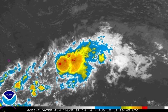
Ok, well I guess we've settled whether it should have ever been called a depression, lol. Now that it's behaving very much like Ernesto, in a very similar situation, I guess we'll see a lot of back-and-forth about whether it's a tropical storm.
Let me be the first to say it sure looks better than a lot of TSs we've seen on here, and if that convective blow-up maintains over the center I won't be surprised at all if we get TS winds in the islands tomorrow. I think this gets named by 11PM or overnight if that convection doesn't drop off. Surely it's already getting late to get warnings up.
Personal Forecast Disclaimer:
The posts in this forum are NOT official forecast and should not be used as such. They are just the opinion of the poster and may or may not be backed by sound meteorological data. They are NOT endorsed by any professional institution or storm2k.org. For official information, please refer to the NHC and NWS products.
0 likes
Re: ATL: SEVEN - Tropical Depression
See if that convection grows near the islands. Otherwise if NHC dissipates it it is probably wise to back off it.
0 likes
-
Shuriken
Re: ATL: SEVEN - Tropical Depression
Actually they have it slowly strengthening to a 40mph TS by 48hrs out, then suddenly croaking within 24hrs after that....which is one of the stranger forecasts I've seen.wxman57 wrote:No, it's not a TS now. It's a weakening depression - IF that. Even the new NHC forecast has it dissipating within 72 hrs, and that may be generous.
It is quite difficult to actually kill a TS-strength circulation in the eastern Caribbean via shear unless it hits land -- witness Iris.
Tonight will be important: For any intensification to occur, I would expect to see CB towers finally penetrate and begin exhausting at 200mb as the storm crosses the 29c isotherm.
0 likes
-
wxman57
- Moderator-Pro Met
- Posts: 23175
- Age: 68
- Joined: Sat Jun 21, 2003 8:06 pm
- Location: Houston, TX (southwest)
Re: ATL: SEVEN - Tropical Depression
ROCK wrote:wxman57 wrote:No, it's not a TS now. It's a weakening depression - IF that. Even the new NHC forecast has it dissipating within 72 hrs, and that may be generous.
I aint giving up on it until I see bones....so just stick him in your pocket for now!
Bones is laughing at this "depression"...
0 likes
-
wxman57
- Moderator-Pro Met
- Posts: 23175
- Age: 68
- Joined: Sat Jun 21, 2003 8:06 pm
- Location: Houston, TX (southwest)
Re: ATL: SEVEN - Tropical Depression
Shuriken wrote:Actually they have it slowly strengthening to a 40mph TS by 48hrs out, then suddenly croaking within 24hrs after that....which is one of the stranger forecasts I've seen.wxman57 wrote:No, it's not a TS now. It's a weakening depression - IF that. Even the new NHC forecast has it dissipating within 72 hrs, and that may be generous.
It is quite difficult to actually kill a TS-strength circulation in the eastern Caribbean via shear unless it hits land -- witness Iris.
Tonight will be important: For any intensification to occur, I would expect to see CB towers finally penetrate and begin exhausting at 200mb as the storm crosses the 29c isotherm.
That's bogus, there's nothing to indicate conditions will suddenly allow it to strengthen then cause it to dissipate. They are just being cautious in case it does produce any TS wind in the islands (which even a tropical wave can).
0 likes
-
ozonepete
- Professional-Met
- Posts: 4743
- Joined: Mon Sep 07, 2009 3:23 pm
- Location: From Ozone Park, NYC / Now in Brooklyn, NY
Re: ATL: SEVEN - Tropical Depression
It is also rounding the bottom of the southward protrusion of the Atlantic High now so that it is changing motion from a little WSW at times today to due West so it will slow a little bit. And the little bit of southward dip it did will take it a little more underneath the coming shear. Although I do think the flare-up of convection right now is partly due to the SW shear initially enhancing the convection by providing exhaust in the upper levels. Let's see what happens as the shear changes to west.
Personal Forecast Disclaimer:
The posts in this forum are NOT official forecast and should not be used as such. They are just the opinion of the poster and may or may not be backed by sound meteorological data. They are NOT endorsed by any professional institution or storm2k.org. For official information, please refer to the NHC and NWS
0 likes
Who is online
Users browsing this forum: No registered users and 57 guests