ATL: DEBBY - Post-Tropical

Moderator: S2k Moderators

Message
Author
Air Force Met
Military Met
Military Met
Posts: 4372
Age: 56
Joined: Tue Jul 08, 2003 9:30 am
Location: Roan Mountain, TN

Re:

#621 Postby Air Force Met » Fri Jun 22, 2012 11:16 am

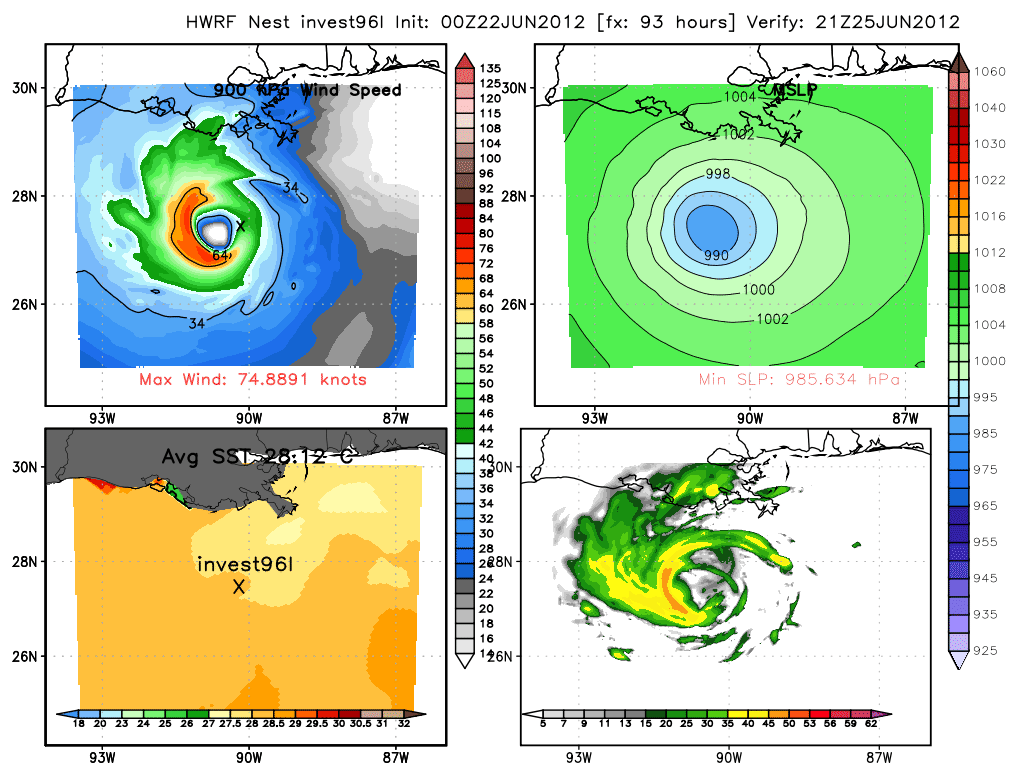
TropicalAnalystwx13 wrote:The GFS Ensemble Mean/ECMWF shows that wind shear will not be a problem for 96L. There is an anticyclone located in the Gulf that should eventually become stacked with the system and provide a low shear environment for the next several days. If 96L goes east, I could see it being a problem close to landfall, but if it goes west, it shouldn't be a problem.


Really not sure what you are looking at. The 72H 250 MB GFS ensembles show an upper low off the S TX coast (25/12z)...as does the operational model. This places 20 kts of southerly shear over the central Gulf.

By 120 hrs+ a high does build over the Gulf but it is over the SOUTHERN Gulf. This places 10-20 kts of westerly shear across the northern Gulf...which is where Debby/96L will be (north of 25N...which is what I was saying).

There is NO anticyclone over the Gulf now...only shear...and the northern Gulf will remain hostile according to the GFS ensembles AND the GFS operational model.
0 likes   

User avatar
Rgv20
S2K Supporter
S2K Supporter
Posts: 2466
Age: 38
Joined: Wed Jan 05, 2011 5:42 pm
Location: Edinburg/McAllen Tx

#622 Postby Rgv20 » Fri Jun 22, 2012 11:17 am

12zGFS sticking with the eastern solution....Of all the Global Models GFS is alone with that idea as of right now.
0 likes   
The following post is NOT an official forecast and should not be used as such. It is just the opinion of the poster and may or may not be backed by sound meteorological data. It is NOT endorsed by any professional institution including storm2k.org For Official Information please refer to the NHC and NWS products.

Dean4Storms
S2K Supporter
S2K Supporter
Posts: 6358
Age: 62
Joined: Sun Aug 31, 2003 1:01 pm
Location: Miramar Bch. FL

#623 Postby Dean4Storms » Fri Jun 22, 2012 11:18 am

12z GFS really backdoors the trough down the eastern CONUS Seaboard backing down the plains ridge capturing Debby and dragging it across Florida.

Really strong trough for this time of year, but if it occurs it would likely pull whatever is in the eastern half of the Gulf eastward.........


http://raleighwx.americanwx.com/models/ ... SLoop.html
0 likes   

User avatar
Hurricane Andrew
S2K Supporter
S2K Supporter
Posts: 1891
Age: 26
Joined: Sun May 23, 2010 2:53 pm
Location: KS

Re: ATL: INVEST 96L - Models

#624 Postby Hurricane Andrew » Fri Jun 22, 2012 11:18 am

Stratosphere747 wrote:0z HWRF at 93 and 126 hrs -

Image

Image

Where do you get those?
0 likes   

The Enthusiast
NREMT-AEMT, WX nerd

Irene '11, Sandy '12, Irma '17 (SAR)

"Hard to think we were born to live this way..." -Wage War

Dean4Storms
S2K Supporter
S2K Supporter
Posts: 6358
Age: 62
Joined: Sun Aug 31, 2003 1:01 pm
Location: Miramar Bch. FL

#625 Postby Dean4Storms » Fri Jun 22, 2012 11:20 am

That sure would put the squeeze play in over the Panhandle gradient and wind wise!! :idea:
0 likes   

User avatar
hurricanefloyd5
Category 5
Category 5
Posts: 1659
Age: 44
Joined: Sun May 02, 2004 10:53 am
Location: Spartanburg
Contact:

Re: ATL: INVEST 96L - Models

#626 Postby hurricanefloyd5 » Fri Jun 22, 2012 11:21 am

0 likes   

User avatar
ROCK
Category 5
Category 5
Posts: 9484
Age: 54
Joined: Tue Aug 17, 2004 7:30 am
Location: Kemah, Texas

Re: ATL: INVEST 96L - Models

#627 Postby ROCK » Fri Jun 22, 2012 11:23 am

the 12Z GFS is the same as the 06Z so not much change. I think its over doing the trof but we shall see...the CMC and EURO come out in a few....I doubt they will clear anything up though.... :lol:
0 likes   

User avatar
PTrackerLA
Category 5
Category 5
Posts: 5277
Age: 41
Joined: Thu Oct 10, 2002 8:40 pm
Location: Lafayette, LA

#628 Postby PTrackerLA » Fri Jun 22, 2012 11:23 am

Amazing the GFS continues to move this east into Florida while the overnight Euro sent it even further south and west into southern TX. Can't remember the last time the globals were holding their ground on such divergent solutions for about two days now.
0 likes   

User avatar
Hurricane Andrew
S2K Supporter
S2K Supporter
Posts: 1891
Age: 26
Joined: Sun May 23, 2010 2:53 pm
Location: KS

#629 Postby Hurricane Andrew » Fri Jun 22, 2012 11:23 am

0 likes   

The Enthusiast
NREMT-AEMT, WX nerd

Irene '11, Sandy '12, Irma '17 (SAR)

"Hard to think we were born to live this way..." -Wage War

User avatar
SoupBone
Category 5
Category 5
Posts: 3111
Joined: Tue Sep 20, 2005 5:24 pm

Re: ATL: INVEST 96L - Discussion

#630 Postby SoupBone » Fri Jun 22, 2012 11:26 am

Air Force Met wrote:
robbielyn wrote:
Jeff masters said there is dry air hampering development in the central gulf. He also said moderate shear will allow for slow development through Saturday night then shear will increase again. So this has alot going against it becoming too strong


And I agree. This thing will never be free of the shear once it moves north of 25. When I sent out my update yesterday to the State I mentioned this very reason for not buying into the Euro/CMC solution on strength. It always looks to me like it will be battling 10-20 kts of shear. Nothing that will kill it...but enough to keep a lid on it.


I believe that a few Louisiana NWS offices agree with this line of thinking as well. While the shear has lessened and may allow for minimal strengthening, 10-20 kts will take most of the punch out of it. For us (in Louisiana), we need to be worried about a slower moving system giving us large amounts of rain, and considering we're already drenched, we have flash flood potentials. Also, we have to worry about the possibility of increased tides and wave action for our coastal parishes.

Personal Forecast Disclaimer:The posts in this forum are NOT official forecast and should not be used as such. They are just the opinion of the poster and may or may not be backed by sound meteorological data. They are NOT endorsed by any professional institution or storm2k.org. For official information, please refer to the NHC and NWS products.
Last edited by SoupBone on Fri Jun 22, 2012 11:29 am, edited 1 time in total.
0 likes   

Dean4Storms
S2K Supporter
S2K Supporter
Posts: 6358
Age: 62
Joined: Sun Aug 31, 2003 1:01 pm
Location: Miramar Bch. FL

#631 Postby Dean4Storms » Fri Jun 22, 2012 11:27 am

I think the differences are two fold between the GFS and ECMWF. The GFS has the Low further north and east and backs the ridging down more. Whereas the ECMWF has the Low closer to 90W and not as far north missing the trough and build the ridge back in much faster.

If the Low forms closer to the NE Tip of the Yucatan I think you have to give the GFS solution more plausibility. All will depend on exactly where the Low develops and with the deeper convection all on the eastern periphery I tend to side with the GFS for now.
0 likes   

tgenius
S2K Supporter
S2K Supporter
Posts: 1160
Joined: Mon May 15, 2006 5:31 pm
Location: Miami, FL

Re: ATL: INVEST 96L - Discussion

#632 Postby tgenius » Fri Jun 22, 2012 11:28 am

pretty safe to say this is going to make for a rainy weekend this weekend in Miami.. maybe that's why they pushed the parade to Monday. :D
0 likes   

Dean4Storms
S2K Supporter
S2K Supporter
Posts: 6358
Age: 62
Joined: Sun Aug 31, 2003 1:01 pm
Location: Miramar Bch. FL

#633 Postby Dean4Storms » Fri Jun 22, 2012 11:29 am

Unless convection gets around to the western periphery I think the GFS is more plausible with this staying east of 90W. Thus getting pulled by the trough.
0 likes   

N2Storms
Category 1
Category 1
Posts: 324
Joined: Thu Sep 04, 2003 1:37 pm
Location: Panama City, Florida

Re:

#634 Postby N2Storms » Fri Jun 22, 2012 11:38 am

[quote="Dean4Storms"]That sure would put the squeeze play in over the Panhandle gradient and wind wise!! :idea:[/quote]


I would love to see us get some good soaking rains but for some reason, Bay County (Panama City) just seems to have some kind of "rain shield" around it and when folks to our West and to our East are picking up fair amounts of Precip, we seem to be left high and dry.
0 likes   

User avatar
wxman57
Moderator-Pro Met
Moderator-Pro Met
Posts: 22979
Age: 67
Joined: Sat Jun 21, 2003 8:06 pm
Location: Houston, TX (southwest)

Re: ATL: INVEST 96L - Models

#635 Postby wxman57 » Fri Jun 22, 2012 11:39 am

I'm fixing some old links on my models page and have another one that changed. I had the link to the current HWRF/GFDL output in text form as being:

ftp://ftp.ncep.noaa.gov/pub/data/nccf/com/hur/prod/

Now that data on the website above is zipped into a grib file and I can't view it. Used to be links there to display the HWRF and GFDL as a table of lat/lon, pressure, max winds. What did that link change to?
0 likes   

User avatar
SouthDadeFish
Professional-Met
Professional-Met
Posts: 2835
Joined: Thu Sep 23, 2010 2:54 pm
Location: Miami, FL
Contact:

#636 Postby SouthDadeFish » Fri Jun 22, 2012 11:39 am

This is the 72 hour 12Z GFS forecast, which illustrates what AFM is talking about with the ULL:

Image

That ULL is producing 20-30 knots of wind in the upper-levels which will most likely lead to our typical sheared June Gulf system. Nothing new here.

Disclaimer: Not a professional forecast, just my opinion.
0 likes   

User avatar
Rgv20
S2K Supporter
S2K Supporter
Posts: 2466
Age: 38
Joined: Wed Jan 05, 2011 5:42 pm
Location: Edinburg/McAllen Tx

#637 Postby Rgv20 » Fri Jun 22, 2012 11:40 am

I'm kind of lost if the following discussion belongs in the model thread......I'm going to put it here because it breakdowns the 6zGFS.

MONSOON DEPRESSION IN THE GULF OF MEXICO...
PREFERENCE: SOUTHEAST-SHIFTED 00Z CANADIAN/00Z ECMWF COMPROMISE
CONFIDENCE: ABOVE AVERAGE FOR TRACK SHAPE/BELOW AVERAGE FOR
PROGRESSION/SPEED

THE 06Z GFS CONTINUES TO DRAG THIS CYCLONE TOWARDS TAMPA...USING A
PAIR OF CONVECTIVE FEEDBACK BULL'S EYES/QPF BOMBS TO LURE ITS
CENTER NORTHEASTWARD...IMPLYING SOUTHWESTERLY VERTICAL WIND SHEAR.
IT HAS BEEN PERSISTENT IN SHOWING THIS TYPE OF SOLUTION FOR THREE
DAYS NOW. THE GENERAL FLOW PATTERN FEATURES A BUILDING WARM CORE
RIDGE ACROSS CENTRAL PLAINS WITH A SECOND WEAKER RIDGE NORTH OF
THE GREATER ANTILLES...AND A NEGATIVELY TILTED UPPER TROUGH
EXTENDING FROM THE EAST COAST INTO THE WESTERN ATLANTIC WITH A
SLIGHT BREAK AT 500/700 HPA ACROSS THE SOUTHEAST. THE GUIDANCE
CONTINUES TO INDICATE THAT THE COL POINT IN THE STEERING PATTERN
IS NEAR NORTHERN FLORIDA/SOUTHERN GEORGIA...WHICH WOULD FORCE A
SYSTEM IN THE GULF TO STEER NORTH AND ULTIMATELY WEST UNDER THE
PLAINS RIDGE DURING THE LATE SHORT RANGE/MEDIUM RANGE PERIOD.
THERE IS ABOVE AVERAGE CONFIDENCE IN THIS IDEA.


HOWEVER...ONCE THE RIDGE BUILDS...THE LOW COULD EASILY ACCELERATE
WEST/WEST-SOUTHWEST SIMILAR TO CLAUDETTE IN 2003. THE ONLY OTHER
ANALOGS TO THIS TYPE OF TROPICAL CYCLONE-TYPE TRACK ARE OCTOBER
1938 AND JUNE 1913.
THE GLOBAL ENSEMBLE SPREAD CONTINUES TO WAVER
EACH DAY...WITH ABOVE AVERAGE SPREAD SEEN TODAY AND WEDNESDAY
WHILE LOWER THAN NORMAL SPREAD WAS SEEN TUESDAY AND THURSDAY.
WHEN THE ENSEMBLE GUIDANCE SHOWS SUCH VARIABILITY...IT IS UNCLEAR
HOW/WHEN TO START ITS WESTWARD PROGRESSION. THE HURRICANE
GUIDANCE BASED ON THE GFS MIRRORS THE GFS...WHICH INCREASES THE
APPARENT MODEL SPREAD WITH THIS SYSTEM. THE PREFERENCE IS FOR A
SOUTHEAST-SHIFTED 00Z CANADIAN/00Z ECMWF COMPROMISE TO SPLIT THE
DIFFERENCE IN THE LARGE SPREAD WITH BELOW AVERAGE CONFIDENCE IN
ITS ULTIMATE WESTWARD PROGRESSION/SPEED. THIS KEEPS GOOD
CONTINUITY WITH MEDIUM RANGE. CONSULT THE LATEST TROPICAL WEATHER
OUTLOOK FROM THE NATIONAL HURRICANE CENTER /NHC/ FOR ITS CURRENT
STATUS.
0 likes   
The following post is NOT an official forecast and should not be used as such. It is just the opinion of the poster and may or may not be backed by sound meteorological data. It is NOT endorsed by any professional institution including storm2k.org For Official Information please refer to the NHC and NWS products.

tolakram
Admin
Admin
Posts: 20009
Age: 62
Joined: Sun Aug 27, 2006 8:23 pm
Location: Florence, KY (name is Mark)

Re: ATL: INVEST 96L - Discussion

#638 Postby tolakram » Fri Jun 22, 2012 11:45 am

I see clouds moving SW near the NE YP, just left of some persistent convection. Perhaps this is the start of something.

Image

Loop: http://wwwghcc.msfc.nasa.gov/cgi-bin/ge ... mframes=10
0 likes   
M a r k
- - - - -
Join us in chat: Storm2K Chatroom Invite. Android and IOS apps also available.

The posts in this forum are NOT official forecasts and should not be used as such. Posts are NOT endorsed by any professional institution or STORM2K.org. For official information and forecasts, please refer to NHC and NWS products.

FutureEM
Tropical Storm
Tropical Storm
Posts: 139
Joined: Sat May 19, 2012 8:16 am

Re: ATL: INVEST 96L - Models

#639 Postby FutureEM » Fri Jun 22, 2012 11:46 am

0 likes   

bella_may
Category 4
Category 4
Posts: 908
Joined: Wed Dec 22, 2010 2:13 pm
Location: SE Mississippi coast

Re: ATL: INVEST 96L - Discussion

#640 Postby bella_may » Fri Jun 22, 2012 11:56 am

I'm just wondering here. Is it possible the TC misses the ridge and the trough and heads due north?
0 likes   


Return to “2012”

Who is online

Users browsing this forum: No registered users and 4 guests