ATL: HELENE - Post-Tropical
Moderator: S2k Moderators
-
Aric Dunn
- Category 5

- Posts: 21238
- Age: 43
- Joined: Sun Sep 19, 2004 9:58 pm
- Location: Ready for the Chase.
- Contact:
Dont over play the shear. the convection has increased as its approaching the the islands and the main shear axis. the tutt that is dropping south is not expected to remain. the aided upper divergence should allow for some more convection tonight and tomorrow. Its not over yet.
0 likes
Note: If I make a post that is brief. Please refer back to previous posts for the analysis or reasoning. I do not re-write/qoute what my initial post said each time.
If there is nothing before... then just ask
Space & Atmospheric Physicist, Embry-Riddle Aeronautical University,
I believe the sky is falling...
If there is nothing before... then just ask
Space & Atmospheric Physicist, Embry-Riddle Aeronautical University,
I believe the sky is falling...
-
SouthDadeFish

- Professional-Met

- Posts: 2835
- Joined: Thu Sep 23, 2010 2:54 pm
- Location: Miami, FL
- Contact:
Re: ATL: SEVEN - Tropical Depression
AMSU made a pass at 00:47Z. Here is the 85 GHz Horiztonal:

Here is the 85 GHz Color composite:

The resolution isn't the best, but you can see the LLC looks to be just north of the deepest convection.
Here is the 85 GHz Color composite:
The resolution isn't the best, but you can see the LLC looks to be just north of the deepest convection.
0 likes
-
Weatherfreak000
Re: ATL: SEVEN - Tropical Depression
If anything, today was a positive trend for TD7 IMO. Aric is right, the depression did not dissipate as predicted. Maybe it wasn't such a bad idea to call it "future Gordon" after all 
Dry air is also going down, it's going to outrun the TUTT which is good. Shear appears an issue, but I think it can make it. It doesn't matter if the circulation opens up at times or not, just as long as it can survive until the western Caribbean it has a chance.
Dry air is also going down, it's going to outrun the TUTT which is good. Shear appears an issue, but I think it can make it. It doesn't matter if the circulation opens up at times or not, just as long as it can survive until the western Caribbean it has a chance.
0 likes
-
ozonepete
- Professional-Met
- Posts: 4743
- Joined: Mon Sep 07, 2009 3:23 pm
- Location: From Ozone Park, NYC / Now in Brooklyn, NY
Re: ATL: SEVEN - Tropical Depression
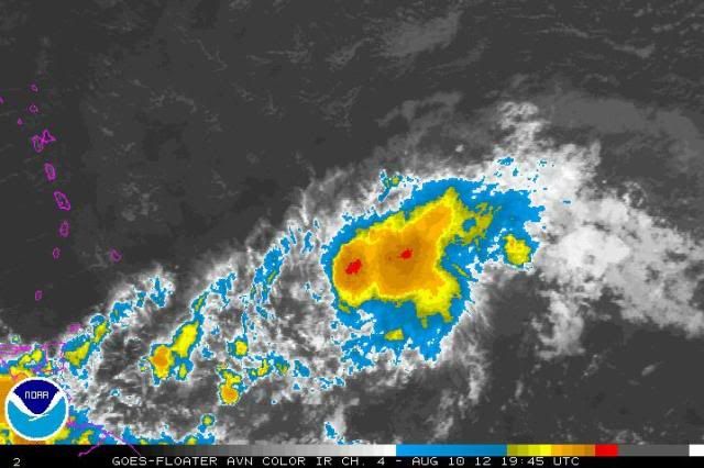
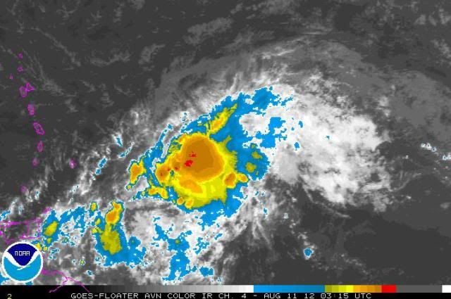
Images from 3:45PM and 11:15M. Which looks more organized?
0 likes
-
ozonepete
- Professional-Met
- Posts: 4743
- Joined: Mon Sep 07, 2009 3:23 pm
- Location: From Ozone Park, NYC / Now in Brooklyn, NY
Re:
psyclone wrote:the second one looks better but it's tough not to improve on the first. both require a good pair of atmospheric beer goggles.
got 'em on!
But in all seriousness, note the much more circular shape in the second one. The better, more circular symmetry aids in getting very moist air in towards the middle of the thunderstorm clusters over the LLC where it can be forced upwards into thunderstorms that ring the center.
0 likes
Re: Re:
ozonepete wrote:psyclone wrote:the second one looks better but it's tough not to improve on the first. both require a good pair of atmospheric beer goggles.
got 'em on!
But in all seriousness, note the much more circular shape in the second one. The better, more circular symmetry aids in getting very moist air in towards the middle of the thunderstorm clusters over the LLC where it can be forced upwards into thunderstorms that ring the center.
it is but it's small, frail and remains embedded in a an environment that is far from ideal. i'm just hungry for a real storm, enough with the appetizers, although the "D" storm did dump a solid 14" on me so those can be exciting.
0 likes
-
ozonepete
- Professional-Met
- Posts: 4743
- Joined: Mon Sep 07, 2009 3:23 pm
- Location: From Ozone Park, NYC / Now in Brooklyn, NY
Re: Re:
psyclone wrote:ozonepete wrote:psyclone wrote:the second one looks better but it's tough not to improve on the first. both require a good pair of atmospheric beer goggles.
got 'em on!
But in all seriousness, note the much more circular shape in the second one. The better, more circular symmetry aids in getting very moist air in towards the middle of the thunderstorm clusters over the LLC where it can be forced upwards into thunderstorms that ring the center.
it is but it's small, frail and remains embedded in a an environment that is far from ideal. i'm just hungry for a real storm, enough with the appetizers, although the "D" storm did dump a solid 14" on me so those can be exciting.
Be careful what you wish for...
0 likes
-
ozonepete
- Professional-Met
- Posts: 4743
- Joined: Mon Sep 07, 2009 3:23 pm
- Location: From Ozone Park, NYC / Now in Brooklyn, NY
Re: ATL: SEVEN - Tropical Depression
Still waitin' on that weakening. Looks pretty impressive.
0 likes
-
Weatherfreak000
Re: ATL: SEVEN - Tropical Depression
It is not here you have to worry about it weakening i'm afraid, it's the environment ahead of it. Shear and dry air are abundant, but any amount of organization TD 7 can maintain is crucial as far as determining what it will do. Seasons routinely seem to have TD's go un-named. I am still on the fence as to guess which path TD 7 will take.
0 likes
-
ozonepete
- Professional-Met
- Posts: 4743
- Joined: Mon Sep 07, 2009 3:23 pm
- Location: From Ozone Park, NYC / Now in Brooklyn, NY
Re: ATL: SEVEN - Tropical Depression
Weatherfreak000 wrote:It is not here you have to worry about it weakening i'm afraid, it's the environment ahead of it. Shear and dry air are abundant, but any amount of organization TD 7 can maintain is crucial as far as determining what it will do. Seasons routinely seem to have TD's go un-named. I am still on the fence as to guess which path TD 7 will take.
That's really well said. I'm not on the fence though. NHC has indicated all along that they are going towards a TS as it goes though the Windward Islands and then dissipates a day or two later. I'm going with them. Especially given how this looks right now and that it won't hit these adverse conditions for at least another 24-48 hours.
Personal Forecast Disclaimer:
The posts in this forum are NOT official forecast and should not be used as such. They are just the opinion of the poster and may or may not be backed by sound meteorological data. They are NOT endorsed by any professional institution or storm2k.org. For official information, please refer to the NHC and NWS products.
0 likes
-
AJC3

- Admin

- Posts: 4155
- Age: 62
- Joined: Tue Aug 31, 2004 7:04 pm
- Location: Ballston Spa, New York
- Contact:
000
WTNT32 KNHC 110545
TCPAT2
BULLETIN
TROPICAL DEPRESSION SEVEN INTERMEDIATE ADVISORY NUMBER 6A
NWS NATIONAL HURRICANE CENTER MIAMI FL AL072012
200 AM AST SAT AUG 11 2012
...TROPICAL DEPRESSION MOVING QUICKLY WESTWARD TOWARD THE WINDWARD
ISLANDS...
SUMMARY OF 200 AM AST...0600 UTC...INFORMATION
----------------------------------------------
LOCATION...13.9N 55.2W
ABOUT 295 MI...475 KM E OF BARBADOS
ABOUT 390 MI...630 KM E OF MARTINIQUE
MAXIMUM SUSTAINED WINDS...35 MPH...55 KM/H
PRESENT MOVEMENT...W OR 275 DEGREES AT 24 MPH...39 KM/H
MINIMUM CENTRAL PRESSURE...1009 MB...29.80 INCHES
WATCHES AND WARNINGS
--------------------
CHANGES WITH THIS ADVISORY...
NONE.
SUMMARY OF WATCHES AND WARNINGS IN EFFECT...
A TROPICAL STORM WATCH IS IN EFFECT FOR...
* GUADELOUPE AND MARTINIQUE
* DOMINICA
* ST. LUCIA
* BARBADOS
* ST. VINCENT AND THE GRENADINES
A TROPICAL STORM WATCH MEANS THAT TROPICAL STORM CONDITIONS ARE
POSSIBLE WITHIN THE WATCH AREA...IN THIS CASE IN 24 TO 36 HOURS.
FOR STORM INFORMATION SPECIFIC TO YOUR AREA...PLEASE MONITOR
PRODUCTS ISSUED BY YOUR NATIONAL METEOROLOGICAL SERVICE.
DISCUSSION AND 48-HOUR OUTLOOK
------------------------------
AT 200 AM AST...0600 UTC...THE CENTER OF TROPICAL DEPRESSION SEVEN
WAS LOCATED NEAR LATITUDE 13.9 NORTH...LONGITUDE 55.2 WEST. THE
DEPRESSION IS MOVING TOWARD THE WEST NEAR 24 MPH...39 KM/H...AND
THIS GENERAL MOTION IS EXPECTED TO CONTINUE THROUGH SUNDAY. ON THE
FORECAST TRACK THE DEPRESSION IS EXPECTED TO APPROACH THE WINDWARD
ISLANDS LATER TODAY.
MAXIMUM SUSTAINED WINDS ARE NEAR 35 MPH...55 KM/H...WITH HIGHER
GUSTS. SOME STRENGTHENING IS POSSIBLE OVER THE NEXT DAY OR SO...AND
THE DEPRESSION COULD BECOME A TROPICAL STORM BEFORE REACHING THE
WINDWARD ISLANDS.
THE ESTIMATED MINIMUM CENTRAL PRESSURE IS 1009 MB...29.80 INCHES.
HAZARDS AFFECTING LAND
----------------------
WIND...TROPICAL STORM CONDITIONS ARE POSSIBLE WITHIN THE WATCH AREA
LATER TODAY AND TONIGHT.
RAINFALL...TOTAL RAINFALL ACCUMULATIONS OF 1 TO 2 INCHES WITH
ISOLATED MAXIMUM AMOUNTS OF 3 INCHES ARE EXPECTED ACROSS PORTIONS
OF THE LESSER ANTILLES THROUGH SATURDAY.
NEXT ADVISORY
-------------
NEXT COMPLETE ADVISORY...500 AM AST.
$$
FORECASTER BEVEN
0 likes
-
Shuriken
Re:
Agreed. To start with, whatever conditions exist at balloon-toss in Guadalupe, et al, will not be identical when the storm arrives, so it's pointless to split hairs over relative differences in wind vectors at various heights -- unless you expect them to be the same when the storm does pass through.Aric Dunn wrote:Dont over play the shear.
(All that said, our TD is looking rather crappy at 2:30am EST...though I don't think shear has much to do with it, as I believe the LLC is still co-located with what convection there is, or at least not too far away.)
0 likes
-
meriland23

- Category 5
- Posts: 1239
- Age: 38
- Joined: Mon Aug 29, 2011 9:29 pm
So what is with NHC, why did they cut the track down? They positive about this dissipation or something?
0 likes
The posts in this forum are NOT official forecast and should not be used as such. They are just the opinion of the poster and may or may not be backed by sound meteorological data. They are NOT endorsed by any professional institution or storm2k.org. For official information, please refer to the NHC and NWS products.
-
Shuriken
Re: Re:
IIRC, it's now been 22 years since the last storm to strike the east coast north of Florida at cat-4 intensity (Hugo, 1989).ozonepete wrote:Be careful what you wish for...psyclone wrote:i'm just hungry for a real storm, enough with the appetizers, although the "D" storm did dump a solid 14" on me so those can be exciting.
0 likes
-
ozonepete
- Professional-Met
- Posts: 4743
- Joined: Mon Sep 07, 2009 3:23 pm
- Location: From Ozone Park, NYC / Now in Brooklyn, NY
Re: ATL: SEVEN - Tropical Depression
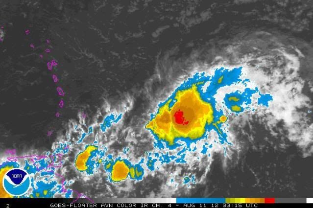
More comparisons: From 8:15PM to 03:15AM. Does it look like it's weakening? Is the circulation around the core more or less symmetric? Does it look like it's more embedded in the ITCZ or less so?

0 likes
-
Caribwxgirl
- S2K Supporter

- Posts: 287
- Joined: Mon Aug 15, 2011 7:25 pm
- Location: Budapest, Hungary (from Kingston, Jamaica)
It looks mighty fine in the 3am pic to my untrained eye
0 likes
Personal Forecast Disclaimer:
The posts in this forum are NOT official forecast. They are just the opinion of the poster and may or may not be backed by sound meteorological data. They are NOT endorsed by any professional institutions or storm2k.org. For official information refer to the NHC and NWS products.
The posts in this forum are NOT official forecast. They are just the opinion of the poster and may or may not be backed by sound meteorological data. They are NOT endorsed by any professional institutions or storm2k.org. For official information refer to the NHC and NWS products.

If there is a 60% chance that TD 7 will become an open wave in the Caribbean then the official forecast is bound by that to avoid confusion. There are still plenty of different scenarios that have 1%,5% and 10% chances of occurring. The models pick up some of those and the pro mets obviously see others.
Here on storm2k we can speculate on outcomes like rail birds at the horse races. When the long shots like Katrina win, we pay a terrible price in lost lives and damage.
Until there is a decrease in forward speed TD 7 might as well be an open wave for modeling purposes. I'm still using Merida on the Yucatan as my benchmark as a weak depression or wave should pass south of there headed for Mexico.
0 likes
-
Gustywind

- Category 5
- Posts: 12334
- Joined: Mon Sep 03, 2007 7:29 am
- Location: Baie-Mahault, GUADELOUPE
000
WTNT32 KNHC 110833
TCPAT2
BULLETIN
TROPICAL DEPRESSION SEVEN ADVISORY NUMBER 7
NWS NATIONAL HURRICANE CENTER MIAMI FL AL072012
500 AM AST SAT AUG 11 2012
...TROPICAL DEPRESSION CONTINUES MOVING RAPIDLY WESTWARD...HURRICANE
HUNTER AIRCRAFT TO INVESTIGATE LATER THIS MORNING...
SUMMARY OF 500 AM AST...0900 UTC...INFORMATION
----------------------------------------------
LOCATION...14.0N 56.1W
ABOUT 235 MI...380 KM ENE OF BARBADOS
ABOUT 330 MI...535 KM E OF MARTINIQUE
MAXIMUM SUSTAINED WINDS...35 MPH...55 KM/H
PRESENT MOVEMENT...W OR 275 DEGREES AT 24 MPH...39 KM/H
MINIMUM CENTRAL PRESSURE...1009 MB...29.80 INCHES
WATCHES AND WARNINGS
--------------------
CHANGES WITH THIS ADVISORY...
NONE.
SUMMARY OF WATCHES AND WARNINGS IN EFFECT...
A TROPICAL STORM WATCH IS IN EFFECT FOR...
* GUADELOUPE AND MARTINIQUE
* DOMINICA
* ST. LUCIA
* BARBADOS
* ST. VINCENT AND THE GRENADINES
A TROPICAL STORM WATCH MEANS THAT TROPICAL STORM CONDITIONS ARE
POSSIBLE WITHIN THE WATCH AREA...IN THIS CASE IN 12 TO 24 HOURS.
FOR STORM INFORMATION SPECIFIC TO YOUR AREA...PLEASE MONITOR
PRODUCTS ISSUED BY YOUR NATIONAL METEOROLOGICAL SERVICE.
DISCUSSION AND 48-HOUR OUTLOOK
------------------------------
AT 500 AM AST...0900 UTC...THE CENTER OF TROPICAL DEPRESSION SEVEN
WAS LOCATED NEAR LATITUDE 14.0 NORTH...LONGITUDE 56.1 WEST. THE
DEPRESSION IS MOVING TOWARD THE WEST NEAR 24 MPH...39 KM/H...AND
THIS GENERAL MOTION IS EXPECTED TO CONTINUE THROUGH SUNDAY. ON THE
FORECAST TRACK...THE DEPRESSION IS EXPECTED TO MOVE THROUGH THE
WINDWARD ISLANDS LATER THIS AFTERNOON OR TONIGHT.
MAXIMUM SUSTAINED WINDS ARE NEAR 35 MPH...55 KM/H...WITH HIGHER
GUSTS. SOME STRENGTHENING IS POSSIBLE OVER THE NEXT DAY OR SO...AND
THE DEPRESSION COULD BECOME A TROPICAL STORM BEFORE REACHING THE
WINDWARD ISLANDS. AFTER PASSING THE WINDWARD ISLANDS...THE SYSTEM
IS FORECAST TO DISSIPATE SUNDAY NIGHT OR MONDAY AS IT ENCOUNTERS
UNFAVORABLE UPPER-LEVEL WINDS.
ESTIMATED MINIMUM CENTRAL PRESSURE IS 1009 MB...29.80 INCHES.
HAZARDS AFFECTING LAND
----------------------
WIND...TROPICAL STORM CONDITIONS ARE POSSIBLE WITHIN THE WATCH AREA
LATER TODAY AND TONIGHT.
RAINFALL...TOTAL RAINFALL ACCUMULATIONS OF 1 TO 2 INCHES WITH
ISOLATED MAXIMUM AMOUNTS OF 3 INCHES ARE EXPECTED ACROSS PORTIONS
OF THE LESSER ANTILLES TODAY.
NEXT ADVISORY
-------------
NEXT INTERMEDIATE ADVISORY...800 AM AST.
NEXT COMPLETE ADVISORY...1100 AM AST.
$$
FORECASTER BEVEN
0 likes
Who is online
Users browsing this forum: No registered users and 55 guests