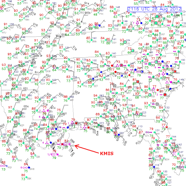
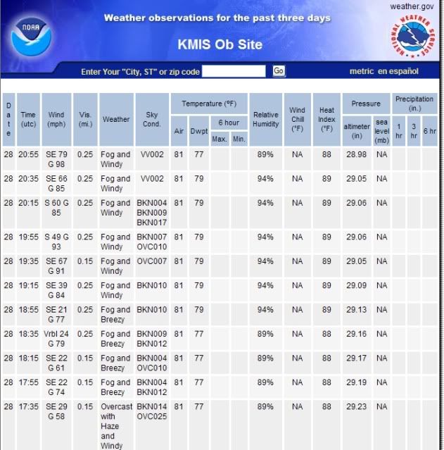
ATL: ISAAC - Post-Tropical - Discussion

Moderator: S2k Moderators

Message
Author
User avatar
EBrads146
Tropical Low
Tropical Low
Posts: 18
Joined: Sat May 12, 2012 10:21 am

Re: ATL: ISAAC - Hurricane - Discussion

#7481 Postby EBrads146 » Tue Aug 28, 2012 4:10 pm

Comparison between today and roughly this time yesterday...

Yesterday:
Image

Today:
Image

It's really quite incredible. Many (including myself) started to write this one off, and BAM. It goes roughly as the NHC has been predicting. Props to them for proving once again why they're the best.

To everyone in Isaac's path: stay safe.
0 likes   

User avatar
gboudx
S2K Supporter
S2K Supporter
Posts: 4080
Joined: Thu Sep 04, 2003 1:39 pm
Location: Rockwall, Tx but from Harvey, La

Re:

#7482 Postby gboudx » Tue Aug 28, 2012 4:10 pm

monicaei wrote::lol: I'm new here, but I think it's cuz it's not hitting texas... YET!

Was lafitte under an evac?


All of JP outside the hurricane protection system. Includes Lafitte, Barataria, Grand Isle and Crown Point.
0 likes   

Aric Dunn
Category 5
Category 5
Posts: 21238
Age: 42
Joined: Sun Sep 19, 2004 9:58 pm
Location: Ready for the Chase.
Contact:

#7483 Postby Aric Dunn » Tue Aug 28, 2012 4:16 pm

appears to have stalled... have to wait for recon to confirm...
0 likes   
Note: If I make a post that is brief. Please refer back to previous posts for the analysis or reasoning. I do not re-write/qoute what my initial post said each time.
If there is nothing before... then just ask :)

Space & Atmospheric Physicist, Embry-Riddle Aeronautical University,
I believe the sky is falling...

Puddinhead
Tropical Low
Tropical Low
Posts: 40
Joined: Fri Aug 17, 2007 11:12 pm
Location: Gentilly Terrace, New Orleans, LA

Re: ATL: ISAAC - Hurricane - Discussion

#7484 Postby Puddinhead » Tue Aug 28, 2012 4:18 pm

Gusts and bands are coming more frequently here in my section of NOLA now. Looking for a break to run a bag of trash out to the garage...LOL.

Local news coverage was showing live footage of the NOLA Lakefront a moment ago (I'm about two miles max south of the Lakefront) and it appeared that Lake Pontchartrain is now over the seawall and covering the recreation area between the Lake and the hurricane protection levee. Camera didn't face the levee, so I couldn't tell how high up the levee the water is so far.

Heaviest wind gusts so far just now...roaring through the pecan tree in the backyard. Which is my biggest worry this time...brittle pecan tree snapping and crushing part of house or, less drastically, the garage on the other side of the tree.
0 likes   

thatwhichisnt
Tropical Depression
Tropical Depression
Posts: 85
Joined: Sat Aug 25, 2012 7:12 pm

Re:

#7485 Postby thatwhichisnt » Tue Aug 28, 2012 4:23 pm

Aric Dunn wrote:appears to have stalled... have to wait for recon to confirm...


It seems to be moving some:
http://tropic.ssec.wisc.edu/real-time/m ... hr_08.html
0 likes   

User avatar
SoupBone
Category 5
Category 5
Posts: 3111
Joined: Tue Sep 20, 2005 5:24 pm

Re: Re:

#7486 Postby SoupBone » Tue Aug 28, 2012 4:25 pm

thatwhichisnt wrote:
Aric Dunn wrote:appears to have stalled... have to wait for recon to confirm...


It seems to be moving some:
http://tropic.ssec.wisc.edu/real-time/m ... hr_08.html


Maybe mine is just stuck, but that image at 15:45 has been there for hours.
0 likes   

Aric Dunn
Category 5
Category 5
Posts: 21238
Age: 42
Joined: Sun Sep 19, 2004 9:58 pm
Location: Ready for the Chase.
Contact:

#7487 Postby Aric Dunn » Tue Aug 28, 2012 4:25 pm

biloxi was very uneventful fairly light winds. heading to NOLA to catch that band about to come through.
0 likes   
Note: If I make a post that is brief. Please refer back to previous posts for the analysis or reasoning. I do not re-write/qoute what my initial post said each time.
If there is nothing before... then just ask :)

Space & Atmospheric Physicist, Embry-Riddle Aeronautical University,
I believe the sky is falling...

hsvwx
Professional-Met
Professional-Met
Posts: 56
Joined: Fri Jun 09, 2006 9:32 pm
Location: Huntsville, AL

Re: Re:

#7488 Postby hsvwx » Tue Aug 28, 2012 4:26 pm

thatwhichisnt wrote:
Aric Dunn wrote:appears to have stalled... have to wait for recon to confirm...


It seems to be moving some:
http://tropic.ssec.wisc.edu/real-time/m ... hr_08.html


The latest imagery on that site is at 1545 UTC or 10:45 AM CDT. It's slowed its progression since that time.
0 likes   

nashrobertsx
Tropical Depression
Tropical Depression
Posts: 85
Joined: Fri Aug 15, 2008 3:55 pm

Re:

#7489 Postby nashrobertsx » Tue Aug 28, 2012 4:26 pm

funster wrote:Isaac does not appear to be making much progress:
http://www.wfaa.com/weather/radar?radar ... img=13&c=y

That's a 40 minute loop, you won't see much in 40 minutes.
0 likes   

tolakram
Admin
Admin
Posts: 20011
Age: 62
Joined: Sun Aug 27, 2006 8:23 pm
Location: Florence, KY (name is Mark)

Re: Re:

#7490 Postby tolakram » Tue Aug 28, 2012 4:28 pm

SoupBone wrote:
thatwhichisnt wrote:
Aric Dunn wrote:appears to have stalled... have to wait for recon to confirm...


It seems to be moving some:
http://tropic.ssec.wisc.edu/real-time/m ... hr_08.html


Maybe mine is just stuck, but that image at 15:45 has been there for hours.


That is a derived product and not a good way to predict movement. Local New Orleans radar is going to be telling us what the storm is doing.

http://radar.weather.gov/radar.php?rid= ... 11&loop=no
0 likes   
M a r k
- - - - -
Join us in chat: Storm2K Chatroom Invite. Android and IOS apps also available.

The posts in this forum are NOT official forecasts and should not be used as such. Posts are NOT endorsed by any professional institution or STORM2K.org. For official information and forecasts, please refer to NHC and NWS products.

Anthysteg00
Tropical Low
Tropical Low
Posts: 38
Joined: Mon Aug 27, 2012 5:50 pm

#7491 Postby Anthysteg00 » Tue Aug 28, 2012 4:28 pm

Thus far I have viewed MIMIC, Radar loops and satellite loops and although I agree it has slowed down, appears to be moving right along the forecast point and perhaps even a touch east of the forecast points. No reason IMHO to believe this thing will indeed stall at all until it is already 30-100 miles inland in SELA. The NHC didn't budge the track because the storm is this close and at this pivotal juncture there appears to be no reason to buy into inaccurate or perhaps off model runs and my evidence to that claim is just about any satellite imagery that you can use to view Isaac. I have absolutely little doubt that RECON will confirm motion dead on or about a touch east of the NHC track.

Personal Forecast Disclaimer:
The posts in this forum are NOT official forecast and should not be used as such. They are just the opinion of the poster and may or may not be backed by sound meteorological data. They are NOT endorsed by any professional institution or storm2k.org. For official information, please refer to the NHC and NWS products.
0 likes   

Aric Dunn
Category 5
Category 5
Posts: 21238
Age: 42
Joined: Sun Sep 19, 2004 9:58 pm
Location: Ready for the Chase.
Contact:

#7492 Postby Aric Dunn » Tue Aug 28, 2012 4:29 pm

radar is showing what appears to be a outer eyewall looking feature developing. almost has convection convection in all quads for the first. lol
0 likes   
Note: If I make a post that is brief. Please refer back to previous posts for the analysis or reasoning. I do not re-write/qoute what my initial post said each time.
If there is nothing before... then just ask :)

Space & Atmospheric Physicist, Embry-Riddle Aeronautical University,
I believe the sky is falling...

User avatar
wkwally
Category 1
Category 1
Posts: 279
Joined: Sun Jun 27, 2010 9:18 pm
Location: Humble, Texas

#7493 Postby wkwally » Tue Aug 28, 2012 4:31 pm

not good if it is stalling as it will give it more chance to be stronger
0 likes   

superstareporter
Tropical Low
Tropical Low
Posts: 31
Joined: Mon Aug 27, 2012 12:06 pm

Re:

#7494 Postby superstareporter » Tue Aug 28, 2012 4:31 pm

Aric Dunn wrote:biloxi was very uneventful fairly light winds. heading to NOLA to catch that band about to come through.


You should have come to Pensacola first them moved to NOLA later, as the waves and wind are pretty impressive out on the beach.
0 likes   

ozonepete
Professional-Met
Professional-Met
Posts: 4743
Joined: Mon Sep 07, 2009 3:23 pm
Location: From Ozone Park, NYC / Now in Brooklyn, NY

Re: ATL: ISAAC - Hurricane - Discussion

#7495 Postby ozonepete » Tue Aug 28, 2012 4:31 pm

Wow, check out these readings. This surface obs from RAP shows station KMIS with SE winds of 70 knots gusting to 85 knots at 2116. The NWS ASOS surface obs from 2055 shows SE at 79 mph gusting to 98mph. Whoa!

Image

Image
0 likes   

jlauderdal
S2K Supporter
S2K Supporter
Posts: 7183
Joined: Wed May 19, 2004 5:46 am
Location: NE Fort Lauderdale
Contact:

Re: ATL: ISAAC - Hurricane - Discussion

#7496 Postby jlauderdal » Tue Aug 28, 2012 4:33 pm

windnrain wrote:Pretty symetrical looking now.


nice radar presentation

Image

Uploaded with ImageShack.us
0 likes   

Aric Dunn
Category 5
Category 5
Posts: 21238
Age: 42
Joined: Sun Sep 19, 2004 9:58 pm
Location: Ready for the Chase.
Contact:

Re: Re:

#7497 Postby Aric Dunn » Tue Aug 28, 2012 4:33 pm

superstareporter wrote:
Aric Dunn wrote:biloxi was very uneventful fairly light winds. heading to NOLA to catch that band about to come through.


You should have come to Pensacola first them moved to NOLA later, as the waves and wind are pretty impressive out on the beach.


I did :) stopped at navrro beach and took video of the surge flooding there.
0 likes   
Note: If I make a post that is brief. Please refer back to previous posts for the analysis or reasoning. I do not re-write/qoute what my initial post said each time.
If there is nothing before... then just ask :)

Space & Atmospheric Physicist, Embry-Riddle Aeronautical University,
I believe the sky is falling...

User avatar
Blinhart
Category 5
Category 5
Posts: 2081
Age: 48
Joined: Thu Sep 08, 2011 3:13 pm
Location: Crowley, La.

Re: ATL: ISAAC - Hurricane - Discussion

#7498 Postby Blinhart » Tue Aug 28, 2012 4:34 pm

TWC just stated they are witnessing something they have never seen before, an inner eye trying to former inside an outer eye. They have no idea what to make of that.
0 likes   
Personal Forecast Disclaimer:
The posts in this forum are NOT official forecast and should not be used as such. They are just the opinion of the poster and may or may not be backed by sound meteorological data. They are NOT endorsed by any professional institution or storm2k.org. For official information, please refer to the NHC and NWS products.

User avatar
wkwally
Category 1
Category 1
Posts: 279
Joined: Sun Jun 27, 2010 9:18 pm
Location: Humble, Texas

#7499 Postby wkwally » Tue Aug 28, 2012 4:34 pm

can sure tell this is getting close to landfall with all of those in here
0 likes   

tolakram
Admin
Admin
Posts: 20011
Age: 62
Joined: Sun Aug 27, 2006 8:23 pm
Location: Florence, KY (name is Mark)

Re: ATL: ISAAC - Hurricane - Discussion

#7500 Postby tolakram » Tue Aug 28, 2012 4:35 pm

0 likes   
M a r k
- - - - -
Join us in chat: Storm2K Chatroom Invite. Android and IOS apps also available.

The posts in this forum are NOT official forecasts and should not be used as such. Posts are NOT endorsed by any professional institution or STORM2K.org. For official information and forecasts, please refer to NHC and NWS products.


Return to “2012”

Who is online

Users browsing this forum: No registered users and 8 guests