ATL: ISAAC - Post-Tropical - Discussion
Moderator: S2k Moderators

Re: ATL: ISAAC - Hurricane - Discussion
He said he's never seen an eye wall form inside the larger eye wall. It's always been the other way around.
0 likes
Personal Forecast Disclaimer:
The posts in this forum are NOT official forecast and should not be used as such. They are just the opinion of the poster and may or may not be backed by sound meteorological data. They are NOT endorsed by any professional institution or storm2k.org. For official information, please refer to the NHC and NWS products.
The posts in this forum are NOT official forecast and should not be used as such. They are just the opinion of the poster and may or may not be backed by sound meteorological data. They are NOT endorsed by any professional institution or storm2k.org. For official information, please refer to the NHC and NWS products.
-
fasterdisaster
- Category 5

- Posts: 1868
- Joined: Mon Sep 19, 2005 4:41 pm
- Location: Miami, Florida

Re: ATL: ISAAC - Hurricane - Discussion
I'd place the center of the eye ~20 miles off shore right now. Landfall will occur soon, just as the radar presentation of the hurricane is improving. We expected this storm to be intensifying on landfall, and it looks like it's doing just that.
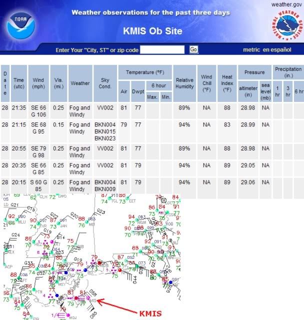
For what it's worth, the KMSI observation is 68 mph sustained gusting to 96 mph as of 2115 UTC. Note that this is an oil platform elevated well above standard measurement height. On land, KBVE is reporting winds of 41 mph sustained gusting to 71 mph as of 2125 UTC. This is very close to the eye, so I'm surprised to see sustained winds of only weak tropical storm strength. It looks like KBVE is located away from the water, though, and we know that the strongest winds will only be experienced at the coast and inland a few miles. However, the winds above the surface are very strong for a weak Cat 1 hurricane, so the tall buildings in New Orleans may experience strong Cat 2 winds with wind gusts above that if it gets into the front-right quadrant of Isaac. Right now, I'm not sure it'll get into that front right quad.
Maybe my eyes are playing tricks on me, but it looks like, from nearby radar observations, that the general motion the past hour or two has been to the right of northwestward.
Last edited by WxGuy1 on Tue Aug 28, 2012 4:54 pm, edited 2 times in total.
0 likes
-
Puddinhead
- Tropical Low

- Posts: 40
- Joined: Fri Aug 17, 2007 11:12 pm
- Location: Gentilly Terrace, New Orleans, LA
Re:
wkwally wrote:still a few hours out
How are things in your area puddin?
The gusts are coming more frequently and are stronger now...Just stood out on the back deck for a few moments between rain showers and with the way some of those gusts roared through the pecan tree I'm not too sure the tree survives too long a period of sustained high-end winds. Neither my wife or I plan on sleeping upstairs in our bedroom tonight...LOL.
0 likes

I have to say, it does appear to strengthening with respect to its eye wall, certainly land interactino could be causing some of this. I also think the worst weather appears as if it will be to the east of New Orleans in Mississippi and St. bernard Parish if this doesnt tighten up more. Although the whole area stands to take a wallop. Could easily be worse wind damage for nola than with katrina, although in the areas immediately east it probably will be less wind damage than K(not that was much left to judge by)
Usually these things are weakening already when they hit. Its not super common to have storm strengthening as it pulls inland in the Northern Gulf, although if it happens, its usually TS's and Cat 1's. I know its relatively common in Texas and Florida though.
Usually these things are weakening already when they hit. Its not super common to have storm strengthening as it pulls inland in the Northern Gulf, although if it happens, its usually TS's and Cat 1's. I know its relatively common in Texas and Florida though.
0 likes

Re: ATL: ISAAC - Hurricane - Discussion
Who on TWC is saying that? Although it's more common in stronger systems, it is part of an Eyewall Replacement Cycle and is not uncommon at all. There are many varities of it.[/quote]
Dr. Rick Knabb i believe[/quote]
I would have to hear it in context. Dr. Knabb is very knowledgeable. Has to be more to what he said.[/quote]
Yes, he and Norcross were saying that the large clear area on radar is an outer eyewall and the small eye is an inner eyewall. but then norcross said that the outer wall would keep inflow from reaching the inner eyewall and would keep the storm from strengthening.
yeah, I was shaking my head too....
0 likes
Ginger-(eye),Dennis,Diana,Kate,Gloria,Charley-(eye),Allison,Arthur,Bertha,Fran,Josephine,Bonnie,Earl,Dennis-(twice),Floyd, Isabel-(eye),Charley,Ophelia-(eyewall),Ernesto,Barry,Hanna,Irene-(eye),Arthur-(eye), Florence, Dorian, and countless depressions, storms, and nor'easters.
-
Aric Dunn
- Category 5
- Posts: 21238
- Age: 43
- Joined: Sun Sep 19, 2004 9:58 pm
- Location: Ready for the Chase.
- Contact:
finally looks like an eyewall is forming ( not that outer eyewall thing)
0 likes
Note: If I make a post that is brief. Please refer back to previous posts for the analysis or reasoning. I do not re-write/qoute what my initial post said each time.
If there is nothing before... then just ask
Space & Atmospheric Physicist, Embry-Riddle Aeronautical University,
I believe the sky is falling...
If there is nothing before... then just ask
Space & Atmospheric Physicist, Embry-Riddle Aeronautical University,
I believe the sky is falling...
-
WeatherGuesser
- Category 5
- Posts: 2672
- Joined: Tue Jun 29, 2010 6:46 am
Re: ATL: ISAAC - Hurricane - Discussion
WxGuy1 wrote:Maybe my eyes are playing tricks on me, but it looks like, from nearby radar observations, that the general motion the past hour or two has been to the right of northwestward.
Yeah, I'm seeing something like NNNW. Definitely nothing even close to West.
0 likes
-
tolakram
- Admin

- Posts: 20167
- Age: 62
- Joined: Sun Aug 27, 2006 8:23 pm
- Location: Florence, KY (name is Mark)
Re: ATL: ISAAC - Hurricane - Discussion
saved loop

0 likes
M a r k
- - - - -
Join us in chat: Storm2K Chatroom Invite. Android and IOS apps also available.
The posts in this forum are NOT official forecasts and should not be used as such. Posts are NOT endorsed by any professional institution or STORM2K.org. For official information and forecasts, please refer to NHC and NWS products.
One more comment -- I think the precip now developing more solidly in the "inner" eye is actually the true eye now finally consolidating. The lack of a robust eyewall is partially what's prevented more significant intensification the past two days. If we had gotten solid convection in this small "inner ring" 12-24 hours ago, I think we would have seen more appreciable strengthening. Fortunately for those on the coast, Isaac is running out of time to strengthen.
For what it's worth, the outer ring of convection is 60-80 miles in diameter. That's not the eye. It just kind of looks like it because Isaac has had such a disorganized inner core until now.
For what it's worth, the outer ring of convection is 60-80 miles in diameter. That's not the eye. It just kind of looks like it because Isaac has had such a disorganized inner core until now.
0 likes
Re:
Aric Dunn wrote:finally looks like an eyewall is forming ( not that outer eyewall thing)
I am not a pro by any means...but that whole outer eyewall thing looks to me to be nothing more than some dry area rotating around the center, or even maybe just where the radar is not seeing the precip. I highly doubt that a high-end TS/low-end hurricane has double eyewalls.
Personal Forecast Disclaimer:
The posts in this forum are NOT official forecast and should not be used as such. They are just the opinion of the poster and may or may not be backed by sound meteorological data. They are NOT endorsed by any professional institution or storm2k.org. For official information, please refer to the NHC and NWS products.
Follow us on
0 likes
Ginger-(eye),Dennis,Diana,Kate,Gloria,Charley-(eye),Allison,Arthur,Bertha,Fran,Josephine,Bonnie,Earl,Dennis-(twice),Floyd, Isabel-(eye),Charley,Ophelia-(eyewall),Ernesto,Barry,Hanna,Irene-(eye),Arthur-(eye), Florence, Dorian, and countless depressions, storms, and nor'easters.
-
Weather Watcher

- Tropical Storm

- Posts: 171
- Joined: Tue Aug 30, 2005 7:03 pm
- Location: Wisconsin
- Contact:
Re: ATL: ISAAC - Hurricane - Discussion
lopl1 is reporting wave height at 33 ft and wind speed at 92mph 80kts
YIKES
YIKES
0 likes
-
Puddinhead
- Tropical Low
- Posts: 40
- Joined: Fri Aug 17, 2007 11:12 pm
- Location: Gentilly Terrace, New Orleans, LA
Re:
fasterdisaster wrote:Interesting how it seems like stronger storms (Katrina, Dennis, Opal) weaken significantly right before landfall on the Gulf Coast, while weaker ones (Isaac, Humberto) seem to tighten up at the last minute.
Interesting current blog post over at Weather Underground by Dr. Jeff Masters about a study that points to the significant part air pollution particles seem to play in weakening storms as they approach the northern Gulf coast under "Intensity Forecast for Isaac":
http://www.wunderground.com/blog/JeffMa ... rynum=2210
0 likes
-
tolakram
- Admin
- Posts: 20167
- Age: 62
- Joined: Sun Aug 27, 2006 8:23 pm
- Location: Florence, KY (name is Mark)
Re: ATL: ISAAC - Hurricane - Discussion
Look at that very small ring, near where that wind gust was reported. Good grief.
0 likes
M a r k
- - - - -
Join us in chat: Storm2K Chatroom Invite. Android and IOS apps also available.
The posts in this forum are NOT official forecasts and should not be used as such. Posts are NOT endorsed by any professional institution or STORM2K.org. For official information and forecasts, please refer to NHC and NWS products.
- - - - -
Join us in chat: Storm2K Chatroom Invite. Android and IOS apps also available.
The posts in this forum are NOT official forecasts and should not be used as such. Posts are NOT endorsed by any professional institution or STORM2K.org. For official information and forecasts, please refer to NHC and NWS products.
-
hurricanes1234
- Category 5
- Posts: 2908
- Joined: Sat Jul 28, 2012 6:19 pm
- Location: Trinidad and Tobago
Re: ATL: ISAAC - Hurricane - Discussion
Making landfall now?
0 likes
PLEASE NOTE: With the exception of information from weather agencies that I may copy and paste here, my posts will NEVER be official, since I am NOT a meteorologist. They are solely my amateur opinion, and may or may not be accurate. Therefore, please DO NOT use them as official details, particularly when making important decisions. Thank you.

Re:
WxGuy1 wrote:One more comment -- I think the precip now developing more solidly in the "inner" eye is actually the true eye now finally consolidating. The lack of a robust eyewall is partially what's prevented more significant intensification the past two days. If we had gotten solid convection in this small "inner ring" 12-24 hours ago, I think we would have seen more appreciable strengthening. Fortunately for those on the coast, Isaac is running out of time to strengthen.
For what it's worth, the outer ring of convection is 60-80 miles in diameter. That's not the eye. It just kind of looks like it because Isaac has had such a disorganized inner core until now.
How far outside the center is the wind swath? I haven't seen anything recently reflecting those figures.
0 likes
-
ozonepete
- Professional-Met

- Posts: 4743
- Joined: Mon Sep 07, 2009 3:23 pm
- Location: From Ozone Park, NYC / Now in Brooklyn, NY
Re: ATL: ISAAC - Hurricane - Discussion
WxGuy1 wrote:I'd place the center of the eye ~20 miles off shore right now. Landfall will occur soon, just as the radar presentation of the hurricane is improving. We expected this storm to be intensifying on landfall, and it looks like it's doing just that.
For what it's worth, the KMSI observation is 68 mph sustained gusting to 96 mph as of 2115 UTC. Note that this is an oil platform elevated well above standard measurement height. On land, KBVE is reporting winds of 41 mph sustained gusting to 71 mph as of 2125 UTC. This is very close to the eye, so I'm surprised to see sustained winds of only weak tropical storm strength. It looks like KBVE is located away from the water, though, and we know that the strongest winds will only be experienced at the coast and inland a few miles. However, the winds above the surface are very strong for a weak Cat 1 hurricane, so the tall buildings in New Orleans may experience strong Cat 2 winds with wind gusts above that if it gets into the front-right quadrant of Isaac. Right now, I'm not sure it'll get into that front right quad.
Maybe my eyes are playing tricks on me, but it looks like, from nearby radar observations, that the general motion the past hour or two has been to the right of northwestward.
Good point! KMIS is 85 meters or 278 feet above the ground level. That's about 28 stories high. So winds would naturally be much higher there.
0 likes
-
wx247

- S2K Supporter

- Posts: 14279
- Age: 42
- Joined: Wed Feb 05, 2003 10:35 pm
- Location: Monett, Missouri
- Contact:
Re: ATL: ISAAC - Hurricane - Discussion
hurricanes1234 wrote:Making landfall now?
No, the center is still offshore. The outer ring is not the center of circulation.
0 likes
Personal Forecast Disclaimer:
The posts in this forum are NOT official forecast and should not be used as such. They are just the opinion of the poster and may or may not be backed by sound meteorological data. They are NOT endorsed by any professional institution or storm2k.org. For official information, please refer to the NHC and NWS products.
The posts in this forum are NOT official forecast and should not be used as such. They are just the opinion of the poster and may or may not be backed by sound meteorological data. They are NOT endorsed by any professional institution or storm2k.org. For official information, please refer to the NHC and NWS products.
Who is online
Users browsing this forum: No registered users and 36 guests