WPAC: GUCHOL - Post-Tropical

Moderator: S2k Moderators

Message
Author
CrazyC83
Professional-Met
Professional-Met
Posts: 33393
Joined: Tue Mar 07, 2006 11:57 pm
Location: Deep South, for the first time!

Re:

#361 Postby CrazyC83 » Sun Jun 17, 2012 5:52 pm

brunota2003 wrote:What does that translate out to in knots? :lol:


I would guess the intensity right now is 105 kt given all the estimates.
0 likes   

User avatar
Infdidoll
Category 2
Category 2
Posts: 667
Age: 46
Joined: Thu Oct 01, 2009 8:39 pm
Location: Temecula, CA

Re: WPAC: GUCHOL - Typhoon (05W)

#362 Postby Infdidoll » Sun Jun 17, 2012 6:03 pm

Not looking so hot today. My husband is still under the impression that there is a Category 4 equivalent super storm on the way and is trying to get me out the door to go pay to put our cars in storage and take a taxi back. I'm thinking we should hold off. Our cars have faced worse unscathed. We're also on the West side of the island and none of the island is likely to get the front, right storm quadrant. This storm has been very hyped on Okinawa. Seems like everyone here is definitely expecting the worst.
0 likes   

CrazyC83
Professional-Met
Professional-Met
Posts: 33393
Joined: Tue Mar 07, 2006 11:57 pm
Location: Deep South, for the first time!

#363 Postby CrazyC83 » Sun Jun 17, 2012 6:11 pm

A storm much weaker than Category 4 can still be extremely dangerous though...
0 likes   

phwxenthusiast
Category 2
Category 2
Posts: 637
Joined: Wed Mar 24, 2010 3:10 am
Location: Holbrook, NY (Long Island)

Re: Re:

#364 Postby phwxenthusiast » Sun Jun 17, 2012 7:35 pm

brunota2003 wrote:
senorpepr wrote:
brunota2003 wrote:So I wasn't too far off on my guesstimate of 105 or 110 knots, then. Surprised JTWC still has it at 125 knots, though...it looks way weaker than that. Good example of why recon is important, I presume.


I'm a huge supporter of letting UAV recon take the load. Cheaper and less man-power requirements... I hope to see in the upcoming years UAV recon becoming a better leveraged tool.

Me too...and with one of the U.S.' large bases in the area, they could fly them straight out of Okinawa, couldn't they? We seem to have the big lead when it comes to recon, so I don't see why we couldn't assist.


i was saying before that WPAC nations can always coordinate with each other and combine resources to mount recon missions... i think Taiwan's DOTSTAR is still operational but they don't always have missions... that's a good start, if other countries have the initiative...
0 likes   

dhoeze
Tropical Storm
Tropical Storm
Posts: 130
Age: 42
Joined: Tue Oct 27, 2009 2:32 am
Location: Manila, Philippines

#365 Postby dhoeze » Sun Jun 17, 2012 7:43 pm

Gurus,

any way this would affect TS Talim?(Fujiwhara Effect)
0 likes   
"Productivity is never an accident. It is always the result of a commitment to excellence, intelligent planning, and focused effort."

Typhoon Hunter
WesternPacificWeather.com
Posts: 1215
Age: 40
Joined: Wed Oct 11, 2006 11:37 am
Location: Hong Kong
Contact:

Re:

#366 Postby Typhoon Hunter » Sun Jun 17, 2012 7:46 pm

CrazyC83 wrote:A storm much weaker than Category 4 can still be extremely dangerous though...


Not in Okinawa, wind really isn't much of an issue there unless you're being a complete idiot and dancing in the street! :D

Looks like Guchol is really ramping down and I wouldn't be surprise if it's about 85kts 1-min at closest pass to Okinawa given what I've seen other typhoons do around the island especially well ahead of the heart of typhoon season as well as SSTs and OHC in the region.

Personal Forecast Disclaimer:
The posts in this forum are NOT official forecast and should not be used as such. They are just the opinion of the poster and may or may not be backed by sound meteorological data. They are NOT endorsed by any professional institution or storm2k.org. For official information, please refer to the NHC and NWS products.
0 likes   
James - Documenting typhoons...

http://www.youtube.com/TyphoonHunter

tolakram
Admin
Admin
Posts: 19165
Age: 60
Joined: Sun Aug 27, 2006 8:23 pm
Location: Florence, KY (name is Mark)

Re: WPAC: GUCHOL - Typhoon (05W)

#367 Postby tolakram » Sun Jun 17, 2012 8:01 pm

Visible

Image
0 likes   
M a r k
- - - - -
Join us in chat: Storm2K Chatroom Invite. Android and IOS apps also available.

The posts in this forum are NOT official forecasts and should not be used as such. Posts are NOT endorsed by any professional institution or STORM2K.org. For official information and forecasts, please refer to NHC and NWS products.

User avatar
cycloneye
Admin
Admin
Posts: 139083
Age: 67
Joined: Thu Oct 10, 2002 10:54 am
Location: San Juan, Puerto Rico

Re: WPAC: GUCHOL - Typhoon (05W)

#368 Postby cycloneye » Sun Jun 17, 2012 8:09 pm

WTPQ20 RJTD 180000
RSMC TROPICAL CYCLONE ADVISORY
NAME TY 1204 GUCHOL (1204)
ANALYSIS
PSTN 180000UTC 22.2N 127.4E GOOD
MOVE N 14KT
PRES 950HPA
MXWD 085KT
GUST 120KT
50KT 80NM
30KT 250NM SOUTHEAST 200NM NORTHWEST
FORECAST
24HF 190000UTC 29.2N 131.3E 85NM 70%
MOVE NNE 23KT
PRES 965HPA
MXWD 070KT
GUST 100KT
48HF 200000UTC 38.1N 138.6E 180NM 70%
MOVE NNE 27KT
PRES 980HPA
MXWD 055KT
GUST 080KT
72HF 210000UTC 41.7N 146.5E 250NM 70% EXTRATROPICAL LOW

Image
0 likes   
Visit the Caribbean-Central America Weather Thread where you can find at first post web cams,radars
and observations from Caribbean basin members Click Here

Typhoon Hunter
WesternPacificWeather.com
Posts: 1215
Age: 40
Joined: Wed Oct 11, 2006 11:37 am
Location: Hong Kong
Contact:

Re: WPAC: GUCHOL - Typhoon (05W)

#369 Postby Typhoon Hunter » Sun Jun 17, 2012 8:14 pm

cycloneye wrote:WTPQ20 RJTD 180000
RSMC TROPICAL CYCLONE ADVISORY
NAME TY 1204 GUCHOL (1204)
ANALYSIS
PSTN 180000UTC 22.2N 127.4E GOOD
MOVE N 14KT
PRES 950HPA
MXWD 085KT
GUST 120KT
50KT 80NM
30KT 250NM SOUTHEAST 200NM NORTHWEST
FORECAST
24HF 190000UTC 29.2N 131.3E 85NM 70%
MOVE NNE 23KT
PRES 965HPA
MXWD 070KT
GUST 100KT
48HF 200000UTC 38.1N 138.6E 180NM 70%
MOVE NNE 27KT
PRES 980HPA
MXWD 055KT
GUST 080KT
72HF 210000UTC 41.7N 146.5E 250NM 70% EXTRATROPICAL LOW

Image


Looks like it's started to make the veer which will track it east of Okinawa, very pleased I decided to sit out going after Guchol!
0 likes   
James - Documenting typhoons...

http://www.youtube.com/TyphoonHunter

User avatar
Infdidoll
Category 2
Category 2
Posts: 667
Age: 46
Joined: Thu Oct 01, 2009 8:39 pm
Location: Temecula, CA

Re:

#370 Postby Infdidoll » Sun Jun 17, 2012 8:17 pm

CrazyC83 wrote:A storm much weaker than Category 4 can still be extremely dangerous though...


We know that all too well from Songda, last year, which we were shocked to discover after we cleaned up all the mess was only supposed to be a Cat 1-2 at best. All depends on where it hits and the terrain.

I was discussing this with some folks, last night, about most damaging storm tracks across Okinawa. This track is one of the least damaging so we are VERY lucky in this case. We've had several category 5 equivalent super typhoons rumble past on that track without too much incident so we're hoping for the same here. Everyone here is well prepared for this storm, though. Being that Okinawa gets blasted all winter long with 30-50kt winds, 50-80kt sustained winds are still a walk in the park.

We just went to TCOR 1 (destructive winds are possible within 12 hours) minutes ago. Everyone is going to start kicking off their typhoon parties and holing up inside with the beer and snacks they raided the commissary for. :wink:
0 likes   

RobWESTPACWX
WestPACMet
WestPACMet
Posts: 1616
Joined: Fri Sep 17, 2010 2:26 am
Location: Tokyo, Japan
Contact:

#371 Postby RobWESTPACWX » Sun Jun 17, 2012 9:30 pm

Good news I think at this time (if there is good news) is that there is a lot of dry air pushing in on this from the west. Just like we been saying though, if the storm went to the left of Okinawa it would be a very bad situation. So much convective activity on that side right now.
0 likes   
Satellites, Charts and Forecasting tools for East Asia at WESTERNPACIFICWEATHER.COM

RobWESTPACWX
WestPACMet
WestPACMet
Posts: 1616
Joined: Fri Sep 17, 2010 2:26 am
Location: Tokyo, Japan
Contact:

Re: WPAC: GUCHOL - Typhoon (05W)

#372 Postby RobWESTPACWX » Sun Jun 17, 2012 9:49 pm

I just created a video update, on this storm and also Talim in the SCS.

[youtube]http://www.youtube.com/watch?v=3PnrJpJqF7I[/youtube]
0 likes   
Satellites, Charts and Forecasting tools for East Asia at WESTERNPACIFICWEATHER.COM

User avatar
euro6208
Category 5
Category 5
Posts: 18547
Joined: Mon Mar 08, 2004 7:50 pm
Location: Guam

Re: WPAC: GUCHOL - Typhoon (05W)

#373 Postby euro6208 » Sun Jun 17, 2012 10:25 pm

weakening steadily...guchol looks to me like a weak category 3 typhoon...

WTPN31 PGTW 180300
MSGID/GENADMIN/JOINT TYPHOON WRNCEN PEARL HARBOR HI//
SUBJ/TROPICAL CYCLONE WARNING//
RMKS/
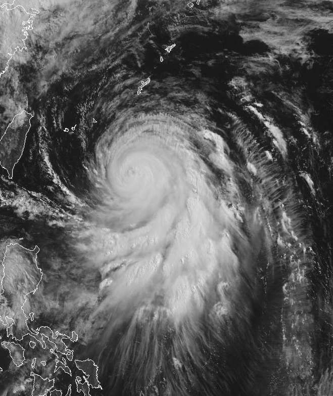
1. TYPHOON 05W (GUCHOL) WARNING NR 029
02 ACTIVE TROPICAL CYCLONES IN NORTHWESTPAC
MAX SUSTAINED WINDS BASED ON ONE-MINUTE AVERAGE
WIND RADII VALID OVER OPEN WATER ONLY
---
WARNING POSITION:
180000Z --- NEAR 22.2N 127.4E
MOVEMENT PAST SIX HOURS - 015 DEGREES AT 14 KTS
POSITION ACCURATE TO WITHIN 020 NM
POSITION BASED ON EYE FIXED BY SATELLITE
PRESENT WIND DISTRIBUTION:
MAX SUSTAINED WINDS - 115 KT, GUSTS 140 KT
WIND RADII VALID OVER OPEN WATER ONLY
RADIUS OF 064 KT WINDS - 055 NM NORTHEAST QUADRANT
050 NM SOUTHEAST QUADRANT
045 NM SOUTHWEST QUADRANT
040 NM NORTHWEST QUADRANT
RADIUS OF 050 KT WINDS - 095 NM NORTHEAST QUADRANT
090 NM SOUTHEAST QUADRANT
080 NM SOUTHWEST QUADRANT
070 NM NORTHWEST QUADRANT
RADIUS OF 034 KT WINDS - 165 NM NORTHEAST QUADRANT
155 NM SOUTHEAST QUADRANT
140 NM SOUTHWEST QUADRANT
130 NM NORTHWEST QUADRANT
REPEAT POSIT: 22.2N 127.4E
---
FORECASTS:
12 HRS, VALID AT:
181200Z --- 25.4N 128.8E
MAX SUSTAINED WINDS - 100 KT, GUSTS 125 KT
WIND RADII VALID OVER OPEN WATER ONLY
RADIUS OF 064 KT WINDS - 050 NM NORTHEAST QUADRANT
045 NM SOUTHEAST QUADRANT
040 NM SOUTHWEST QUADRANT
040 NM NORTHWEST QUADRANT
RADIUS OF 050 KT WINDS - 090 NM NORTHEAST QUADRANT
085 NM SOUTHEAST QUADRANT
075 NM SOUTHWEST QUADRANT
070 NM NORTHWEST QUADRANT
RADIUS OF 034 KT WINDS - 165 NM NORTHEAST QUADRANT
155 NM SOUTHEAST QUADRANT
145 NM SOUTHWEST QUADRANT
140 NM NORTHWEST QUADRANT
VECTOR TO 24 HR POSIT: 030 DEG/ 21 KTS
---
24 HRS, VALID AT:
190000Z --- 29.0N 131.2E
MAX SUSTAINED WINDS - 085 KT, GUSTS 105 KT
WIND RADII VALID OVER OPEN WATER ONLY
RADIUS OF 064 KT WINDS - 045 NM NORTHEAST QUADRANT
040 NM SOUTHEAST QUADRANT
040 NM SOUTHWEST QUADRANT
035 NM NORTHWEST QUADRANT
RADIUS OF 050 KT WINDS - 080 NM NORTHEAST QUADRANT
080 NM SOUTHEAST QUADRANT
075 NM SOUTHWEST QUADRANT
070 NM NORTHWEST QUADRANT
RADIUS OF 034 KT WINDS - 165 NM NORTHEAST QUADRANT
160 NM SOUTHEAST QUADRANT
150 NM SOUTHWEST QUADRANT
145 NM NORTHWEST QUADRANT
VECTOR TO 36 HR POSIT: 040 DEG/ 23 KTS
---
36 HRS, VALID AT:
191200Z --- 32.6N 134.6E
MAX SUSTAINED WINDS - 065 KT, GUSTS 080 KT
WIND RADII VALID OVER OPEN WATER ONLY
BECOMING EXTRATROPICAL
RADIUS OF 050 KT WINDS - 065 NM NORTHEAST QUADRANT
065 NM SOUTHEAST QUADRANT
060 NM SOUTHWEST QUADRANT
055 NM NORTHWEST QUADRANT
RADIUS OF 034 KT WINDS - 165 NM NORTHEAST QUADRANT
165 NM SOUTHEAST QUADRANT
150 NM SOUTHWEST QUADRANT
145 NM NORTHWEST QUADRANT
VECTOR TO 48 HR POSIT: 050 DEG/ 24 KTS
---
EXTENDED OUTLOOK:
48 HRS, VALID AT:
200000Z --- 35.7N 139.1E
MAX SUSTAINED WINDS - 050 KT, GUSTS 065 KT
WIND RADII VALID OVER OPEN WATER ONLY
EXTRATROPICAL
VECTOR TO 72 HR POSIT: 055 DEG/ 24 KTS
---
72 HRS, VALID AT:
210000Z --- 41.1N 149.5E
MAX SUSTAINED WINDS - 035 KT, GUSTS 045 KT
WIND RADII VALID OVER OPEN WATER ONLY
EXTRATROPICAL
---
REMARKS:
180300Z POSITION NEAR 23.0N 127.8E.
TYPHOON (TY) 05W (GUCHOL), LOCATED APPROXIMATELY 265 NM SOUTH OF
KADENA AB, OKINAWA, HAS TRACKED NORTH-NORTHEASTWARD AT 14 KNOTS OVER
THE PAST SIX HOURS. MAXIMUM SIGNIFICANT WAVE HEIGHT AT 180000Z IS 60
FEET. NEXT WARNINGS AT 180900Z, 181500Z, 182100Z AND 190300Z. REFER
TO TROPICAL DEPRESSION 06W (TALIM) WARNINGS (WTPN32 PGTW) FOR SIX-
HOURLY UPDATES.//

Image

WDPN31 PGTW 180300
MSGID/GENADMIN/JOINT TYPHOON WRNCEN PEARL HARBOR HI//
SUBJ/PROGNOSTIC REASONING FOR TYPHOON 05W (GUCHOL) WARNING NR 29//
RMKS/
1. FOR METEOROLOGISTS.
2. 6 HOUR SUMMARY AND ANALYSIS.
TYPHOON (TY) 05W (GUCHOL), LOCATED APPROXIMATELY 265 NM SOUTH OF
KADENA AB, OKINAWA, HAS TRACKED NORTH-NORTHEASTWARD AT 14 KNOTS OVER
THE PAST SIX HOURS. ANIMATED MULTISPECTRAL SATELLITE IMAGERY SHOWS
THE EYEWALL HAS BEEN DETERIORATING OVER THE PAST SIX HOURS. DEEP
CONVECTION OBSERVED WITHIN THE ENHANCED INFRARED (EIR) SATELLITE
IMAGERY HAS DIMINISHED ALONG THE SOUTHEASTERN QUADRANT OF THE LOW
LEVEL CIRCULATION CENTER (LLCC). A SERIES OF MICROWAVE IMAGES,
INCLUDING THE MOST RECENT 172150Z SSMIS PASS, SUPPORT THE BREAKDOWN
OF DEEP CONVECTION. THE INITIAL INTENSITY HAS BEEN ADJUSTED TO 115
KNOTS TO REFLECT THIS OBSERVED WEAKENING TREND AND IS SUPPORTED BY A
5.5/6.5 DVORAK FIX FROM PGTW. THE INITIAL POSITION IS BASED ON THE
PRESENCE OF THE CLOUD FILLED EYE FEATURE AND THE FIX BY PGTW. UPPER-
LEVEL ANALYSIS INDICATES THE MESOSCALE ANTICYCLONE REMAINS SLIGHTLY
DISPLACED FROM THE LOW-LEVEL CIRCULATION CENTER (LLCC). THIS FEATURE
CONTINUES TO VENT THE SYSTEM ALONG THE EQUATORWARD OUTFLOW CHANNEL.
TY 05W HAS RECENTLY SHIFTED TO AN EAST-NORTHEASTWARD TRACK AROUND
THE AXIS OF THE DEEP SUBTROPICAL RIDGE (STR).
3. FORECAST REASONING.
A. NO CHANGE TO THE FORECAST PHILOSOPHY SINCE THE PREVIOUS
PROGNOSTIC REASONING MESSAGE.
B. TY 05W IS EXPECTED TO TRACK EAST-NORTHEAST AROUND THE
NORTHWESTERN PERIPHERY OF THE STEERING STR. AN UPPER-LEVEL TROUGH
LOCATED OVER EASTERN CHINA IS FORECAST TO MODIFY THE STR FURTHER AS
TY 05W TRACKS TOWARDS JAPAN. MODEL GUIDANCE IS IN GOOD AGREEMENT
THROUGH TAU 36, SHOWING TY 05W GRADUALLY WEAKENING AS THE OVERALL
ENVIRONMENT DETERIORATES. THE WEAKENING TREND WILL BEGIN SLOWLY AS
VERTICAL WIND SHEAR (VWS) INCREASES AS TY 05W APPROACHES THE MID-
LATITUDE FRONTAL BOUNDARY ALONG THE EASTERN COAST OF JAPAN. AS A LOW
THAT IS CURRENTLY LOCATED OVER NORTHEASTERN CHINA MOVES TOWARDS THE
SEA OF JAPAN, VWS WILL INCREASE FURTHER WEAKENING TY 05W BY TAU 36
AND BEGIN THE PROCESS OF EXTRA-TROPICAL TRANSITION (ETT). SEA
SURFACE TEMPERATURES (SSTS) SLOWLY STARTED TO DECREASE AND WILL
CONTINUE ON THIS TREND THROUGHOUT THE FORECAST PERIOD. WITHIN THE
NEXT 24 HOURS SSTS WILL DROP BELOW FAVORABLE CONDITIONS FOR
DEVELOPMENT, LEADING TO FURTHER WEAKENING OF THE LLCC. THE FORECAST
KEEPS THE TRACK TO THE WEST OF TOKYO AS THE SYSTEM COMPLETES ETT BY
TAU 48. THE THOUGHT PROCESS FOR THE FORECAST IS THAT MODEL GUIDANCE
IS TRACKING TOWARDS THE MID-LEVEL VORTICITY FIELDS, WHILE THE LLCC
IS EXPECTED TO TRACK ALONG THE STATIONARY FRONTAL BOUNDARY LOCATED
ALONG COASTAL JAPAN. LAND EFFECTS ON THE LLCC DURING THE ETT PROCESS
WILL CREATE A VERY DISORGANIZED STRUCTURE BETWEEN TAU 48 AND 72.
THERE IS HIGH CONFIDENCE IN THE FORECAST TRACK THROUGH TAU 36, BUT
DECREASES TO LOW BEYOND TAU 36 AS THE FORECAST TRACK DIFFERS FROM
THE MAJORITY OF MODEL GUIDANCE WITHIN THE CONSENSUS.//
NNNN
0 likes   
Remember, all of my post aren't official. For official warnings and discussions, Please refer to your local NWS products...

NWS for the Western Pacific

https://www.weather.gov/gum/

User avatar
euro6208
Category 5
Category 5
Posts: 18547
Joined: Mon Mar 08, 2004 7:50 pm
Location: Guam

Re: WPAC: GUCHOL - Typhoon (05W)

#374 Postby euro6208 » Sun Jun 17, 2012 10:52 pm

Image
0 likes   
Remember, all of my post aren't official. For official warnings and discussions, Please refer to your local NWS products...

NWS for the Western Pacific

https://www.weather.gov/gum/

Typhoon Hunter
WesternPacificWeather.com
Posts: 1215
Age: 40
Joined: Wed Oct 11, 2006 11:37 am
Location: Hong Kong
Contact:

#375 Postby Typhoon Hunter » Sun Jun 17, 2012 11:10 pm

Super video as always Rob!
0 likes   
James - Documenting typhoons...

http://www.youtube.com/TyphoonHunter

dexterlabio
Category 5
Category 5
Posts: 3406
Joined: Sat Oct 24, 2009 11:50 pm

Re:

#376 Postby dexterlabio » Mon Jun 18, 2012 12:11 am

RobWESTPACWX wrote:Guchol is now getting to the point where it will be enhancing the SW monsoon over the PI. The risk of heavy rains, flooding and landslides are going to be increasing overnight tonight now.


just saw this post Rob. that was a very good call. there WERE heavy rains for hours from midnight till the early morning in Manila area. im amazed you were able to predict the timing of the monsoon rains hitting PI correctly. PAGASA has always been saying the monsoon will affect Luzon for days now...but there were no definite time when the heaviest rains from the monsoon will fall. I think it is harder to forecast the estimated time and intensity of rains from the monsoon than to predict a storm's track.
0 likes   
Personal Forecast Disclaimer:
The posts in this forum are NOT official forecast and should not be used as such. They are just the opinion of the poster and may or may not be backed by sound meteorological data. They are NOT endorsed by any professional institution or storm2k.org. For official information, please refer to the NHC and NWS products.

User avatar
ManilaTC
WesternPacificWeather.com
Posts: 592
Age: 45
Joined: Mon Oct 26, 2009 5:13 am
Location: Mandaluyong City, Philippines
Contact:

Re: WPAC: GUCHOL - Typhoon (05W)

#377 Postby ManilaTC » Mon Jun 18, 2012 1:00 am

dexterlabio wrote:
RobWESTPACWX wrote:Guchol is now getting to the point where it will be enhancing the SW monsoon over the PI. The risk of heavy rains, flooding and landslides are going to be increasing overnight tonight now.


just saw this post Rob. that was a very good call. there WERE heavy rains for hours from midnight till the early morning in Manila area. im amazed you were able to predict the timing of the monsoon rains hitting PI correctly. PAGASA has always been saying the monsoon will affect Luzon for days now...but there were no definite time when the heaviest rains from the monsoon will fall. I think it is harder to forecast the estimated time and intensity of rains from the monsoon than to predict a storm's track.


In my observation, usually when a storm gets to an angle in relation to the Philippine Archipelago, the maximum effect of the Southwest Monsoon is felt in Metro Manila and in areas in Southwest Luzon and Western Visayas.

That area would be anywhere East of Northern Luzon, especially east of Batanes and Cagayan provinces.
0 likes   
The above post is NOT official and should not be used as such. It is my opinion and may or may not be backed by sound meteorological data. It is not endorsed by any professional institution or storm2k.org. Please refer to your official national weather agency.

WEB http://goo.gl/JDiKXB | FB https://goo.gl/N5sIle | @ManilaTC

RobWESTPACWX
WestPACMet
WestPACMet
Posts: 1616
Joined: Fri Sep 17, 2010 2:26 am
Location: Tokyo, Japan
Contact:

Re: WPAC: GUCHOL - Typhoon (05W)

#378 Postby RobWESTPACWX » Mon Jun 18, 2012 1:23 am

An Eye wall is almost visible on Radar.

Image
0 likes   
Satellites, Charts and Forecasting tools for East Asia at WESTERNPACIFICWEATHER.COM

User avatar
Infdidoll
Category 2
Category 2
Posts: 667
Age: 46
Joined: Thu Oct 01, 2009 8:39 pm
Location: Temecula, CA

Re: WPAC: GUCHOL - Typhoon (05W)

#379 Postby Infdidoll » Mon Jun 18, 2012 1:51 am

Is it just me or is the storm not quite veering NE yet? If it doesn't start a sharp recurve soon, I'm wondering if we could end up feeling a little more intensity than we previously thought.
0 likes   

RobWESTPACWX
WestPACMet
WestPACMet
Posts: 1616
Joined: Fri Sep 17, 2010 2:26 am
Location: Tokyo, Japan
Contact:

#380 Postby RobWESTPACWX » Mon Jun 18, 2012 2:16 am

I noticed it is going a little more N at this time as well. Good news on the other hand its moving at 30kph right now and increasing in speed.
0 likes   
Satellites, Charts and Forecasting tools for East Asia at WESTERNPACIFICWEATHER.COM


Return to “2012”

Who is online

Users browsing this forum: No registered users and 112 guests