ATL: CHRIS - Post-Tropical
Moderator: S2k Moderators

Re: ATL: CHRIS - Tropical Storm
If Chris does obtain hurricane status, then would that break a record for the earliest northern formed hurricane of any season?
0 likes
"People might not get all they work for in this world, but they must certainly work for all they get."- Frederick Douglass
-
brunota2003

- S2K Supporter

- Posts: 9476
- Age: 33
- Joined: Sat Jul 30, 2005 9:56 pm
- Location: Stanton, KY...formerly Havelock, NC
- Contact:
-
DanieleItalyRm

- Category 1

- Posts: 486
- Age: 38
- Joined: Mon Sep 22, 2008 7:52 am
- Location: Rome - Italy - Mediterranean sea
Re: ATL: CHRIS - Tropical Storm
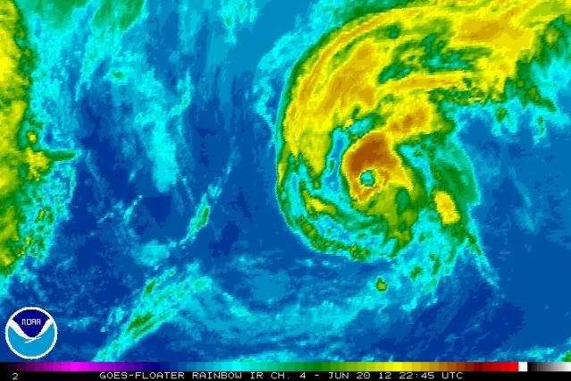
Very interesting Chris. It moves on water of 22-24 ° C. It had a tropical transition process. It shows many tropical cyclones occurred in the Mediterranean Sea.
CHRIS 50 Kt:

But 'even this was a clear tropical storm (deserved at least subtropical), although very small (Invest 92L May 2012); it occurred under conditions similar to Chris...


CHRIS 50 Kt:

But 'even this was a clear tropical storm (deserved at least subtropical), although very small (Invest 92L May 2012); it occurred under conditions similar to Chris...


0 likes
-
ozonepete
- Professional-Met

- Posts: 4743
- Joined: Mon Sep 07, 2009 3:23 pm
- Location: From Ozone Park, NYC / Now in Brooklyn, NY
Re: ATL: CHRIS - Tropical Storm
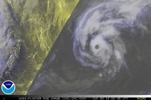
This is of course not the first time we've seen this happen, but it's always unusual to see a TC like this getting better organized and forming an eye over water this cool. But no matter how you slice it, that's not an "eye-like feature"; that's an eye.
0 likes
-
Aric Dunn
- Category 5

- Posts: 21228
- Age: 41
- Joined: Sun Sep 19, 2004 9:58 pm
- Location: Ready for the Chase.
- Contact:
So who would want to bet that .. forward motion of 20mph+ and 60mph sustained is actually producing sustained hurricane force winds.
0 likes
Note: If I make a post that is brief. Please refer back to previous posts for the analysis or reasoning. I do not re-write/qoute what my initial post said each time.
If there is nothing before... then just ask
Space & Atmospheric Physicist, Embry-Riddle Aeronautical University,
I believe the sky is falling...
If there is nothing before... then just ask
Space & Atmospheric Physicist, Embry-Riddle Aeronautical University,
I believe the sky is falling...
-
ozonepete
- Professional-Met
- Posts: 4743
- Joined: Mon Sep 07, 2009 3:23 pm
- Location: From Ozone Park, NYC / Now in Brooklyn, NY
Re: ATL: CHRIS - Tropical Storm
Last edited by ozonepete on Wed Jun 20, 2012 8:46 pm, edited 1 time in total.
0 likes
-
ozonepete
- Professional-Met
- Posts: 4743
- Joined: Mon Sep 07, 2009 3:23 pm
- Location: From Ozone Park, NYC / Now in Brooklyn, NY
Re: ATL: CHRIS - Tropical Storm
Oh, and yes, I'd be very willing to bet that there are 80 mph winds going on somewhere in the right front quadrant. I've seen a number of hurricanes passing east of New England or Canada, further north than where Chris is, that had a similar structure on satellite and were producing 80 mph winds.
0 likes
-
cycloneye

- Admin

- Posts: 139094
- Age: 67
- Joined: Thu Oct 10, 2002 10:54 am
- Location: San Juan, Puerto Rico
Re: ATL: CHRIS - Tropical Storm
Almost a hurricane.
20/2345 UTC 38.6N 47.5W T3.5/3.5 CHRIS -- Atlantic
http://www.ssd.noaa.gov/PS/TROP/tdpositions.html
20/2345 UTC 38.6N 47.5W T3.5/3.5 CHRIS -- Atlantic
http://www.ssd.noaa.gov/PS/TROP/tdpositions.html
0 likes
Visit the Caribbean-Central America Weather Thread where you can find at first post web cams,radars
and observations from Caribbean basin members Click Here
and observations from Caribbean basin members Click Here
-
CrazyC83
- Professional-Met
- Posts: 33393
- Joined: Tue Mar 07, 2006 11:57 pm
- Location: Deep South, for the first time!
Re: ATL: CHRIS - Tropical Storm
ozonepete wrote:Oh, and yes, I'd be very willing to bet that there are 80 mph winds going on somewhere in the right front quadrant. I've seen a number of hurricanes passing east of New England or Canada, further north than where Chris is, that had a similar structure on satellite and were producing 80 mph winds.
Over the cooler water and higher latitudes, I don't think those winds are making it down to the surface.
0 likes
-
ozonepete
- Professional-Met
- Posts: 4743
- Joined: Mon Sep 07, 2009 3:23 pm
- Location: From Ozone Park, NYC / Now in Brooklyn, NY
Re: ATL: CHRIS - Tropical Storm
CrazyC83 wrote:Over the cooler water and higher latitudes, I don't think those winds are making it down to the surface.
The NHC is saying that surface winds are 60 mph, not winds above the ground. It doesn't matter what's going on above ground. Why would cooler water and the latitude have anything to do with Aric's proposition?
Edited to account for the fact that forward speed is included in wind speed.
Last edited by ozonepete on Wed Jun 20, 2012 8:41 pm, edited 2 times in total.
0 likes
-
brunota2003
- S2K Supporter
- Posts: 9476
- Age: 33
- Joined: Sat Jul 30, 2005 9:56 pm
- Location: Stanton, KY...formerly Havelock, NC
- Contact:
Max sustained winds account for forward speed...therefore, the wind speed is really 40 mph, with the 20 mph forward motion added to it, to get the max wind speed of 60 mph. There are no "80 mph" winds.
If you don't believe me for whatever reason, here are a couple links from the AOML TC FAQ page:
http://www.aoml.noaa.gov/hrd/tcfaq/D4.html
http://www.aoml.noaa.gov/hrd/tcfaq/D6.html
If you don't believe me for whatever reason, here are a couple links from the AOML TC FAQ page:
The maximum sustained wind mentioned in the advisories that NHC issues for tropical storms and hurricanes are the highest 1 min surface winds occurring within the circulation of the system. These "surface" winds are those observed (or, more often, estimated) to occur at the standard meteorological height of 10 m (33 ft) in an unobstructed exposure (i.e., not blocked by buildings or trees).
http://www.aoml.noaa.gov/hrd/tcfaq/D4.html
http://www.aoml.noaa.gov/hrd/tcfaq/D6.html
Last edited by brunota2003 on Wed Jun 20, 2012 8:40 pm, edited 1 time in total.
0 likes
Just a small town southern boy helping other humans.
-
ozonepete
- Professional-Met
- Posts: 4743
- Joined: Mon Sep 07, 2009 3:23 pm
- Location: From Ozone Park, NYC / Now in Brooklyn, NY
Re:
brunota2003 wrote:Max sustained winds account for forward speed...therefore, the wind speed is really 40 mph, with the 20 mph forward motion added to it, to get the max wind speed of 60 mph. There are no "80 mph" winds.
I completely went off the rails on that. I knew that, or at least thought I did, lol. But the presentation does not look like it has 40 mph winds. Does Dvorak ADT use forward speed as well?
0 likes
-
brunota2003
- S2K Supporter
- Posts: 9476
- Age: 33
- Joined: Sat Jul 30, 2005 9:56 pm
- Location: Stanton, KY...formerly Havelock, NC
- Contact:
-
ozonepete
- Professional-Met
- Posts: 4743
- Joined: Mon Sep 07, 2009 3:23 pm
- Location: From Ozone Park, NYC / Now in Brooklyn, NY
Re:
brunota2003 wrote:That one I'm not sure about, but I'm sure they are factored into everything somewhere
Ok, well we will certainly have to find out. I don't remember reading it back in the day when I slogged thorough the whole documentation. But guess I'll have to do it again.
0 likes
-
cycloneye
- Admin
- Posts: 139094
- Age: 67
- Joined: Thu Oct 10, 2002 10:54 am
- Location: San Juan, Puerto Rico
Re: ATL: CHRIS - Tropical Storm
TROPICAL STORM CHRIS DISCUSSION NUMBER 6
NWS NATIONAL HURRICANE CENTER MIAMI FL AL032012
1100 PM AST WED JUN 20 2012
CHRIS HAS HAD WHAT COULD BE CONSIDERED AN EYE FOR THE PAST SEVERAL
HOURS. HOWEVER...SUBJECTIVE AND OBJECTIVE SATELLITE INTENSITY
ESTIMATES DO NOT SUPPORT ANY SIGNIFICANT CHANGE IN STRENGTH. THE
MAXIMUM WINDS ARE THEREFORE BEING KEPT AT 50 KT. EVEN IF CHRIS IS
A LITTLE STRONGER...THE CYCLONE IS NOW MOVING OVER SEA SURFACE
TEMPERATURES LESS THAN 22C...AND THE MARINE BOUNDARY LAYER COULD BE
TOO STABLE TO ALLOW STRONGER WINDS TO BE MIXED TO THE OCEAN
SURFACE.
THE INITIAL MOTION IS 075 DEGREES AT 19 KT...AND CHRIS WILL LIKELY
BEGIN TO DECELERATE AND LOOP COUNTERCLOCKWISE WHILE INTERACTING
WITH A DEVELOPING UPPER LOW TO ITS NORTH. THERE IS VERY LITTLE
DISPARITY BETWEEN THE TRACK MODELS OVER THE NEXT COUPLE OF DAYS.
THE GLOBAL MODELS ALSO SEEM TO AGREE THAT CHRIS WILL BE ABSORBED BY
OR MERGE WITH ANOTHER EXTRATROPICAL LOW BY 72 HOURS.
THE POST-TROPICAL TRANSITION IS THE TRICKIEST PART OF THE FORECAST.
THE FSU PHASE SPACE DIAGRAMS STILL ARGUE THAT CHRIS WILL DEVELOP A
DEEPER WARM CORE OVER THE NEXT FEW DAYS. HOWEVER...THE GFS FIELDS
SHOW CHRIS BEGINNING TO INTERACT WITH A FRONTAL BOUNDARY TO ITS
NORTH IN ABOUT 24 HOURS...ENDING UP ON THE COLD SIDE OF THE
BOUNDARY BY 48 HOURS. CHRIS COULD BECOME POST-TROPICAL SOMETIME
OVER THE NEXT 24 HOURS IF IT LOSES ITS DEEP CONVECTION...AND IT
SHOULD BE INVOLVED WITH THE FRONT ENOUGH TO BE EXTRATROPICAL BY 36
HOURS.
THE INTENSITY IS EXPECTED TO CHANGE LITTLE OVER THE NEXT 24 HOURS.
GRADUAL WEAKENING SHOULD START WHEN CHRIS BECOMES EXTRATROPICAL.
FORECAST POSITIONS AND MAX WINDS
INIT 21/0300Z 38.9N 46.4W 50 KT 60 MPH
12H 21/1200Z 40.3N 43.6W 50 KT 60 MPH
24H 22/0000Z 43.0N 42.1W 50 KT 60 MPH...POST-TROPICAL
36H 22/1200Z 44.5N 43.2W 45 KT 50 MPH...POST-TROP/EXTRATROP
48H 23/0000Z 43.8N 45.4W 40 KT 45 MPH...POST-TROP/EXTRATROP
72H 24/0000Z...ABSORBED BY ANOTHER EXTRATROPICAL LOW
$$
FORECASTER BERG
0 likes
Visit the Caribbean-Central America Weather Thread where you can find at first post web cams,radars
and observations from Caribbean basin members Click Here
and observations from Caribbean basin members Click Here
-
CrazyC83
- Professional-Met
- Posts: 33393
- Joined: Tue Mar 07, 2006 11:57 pm
- Location: Deep South, for the first time!
Re: ATL: CHRIS - Tropical Storm
EVEN IF CHRIS IS
A LITTLE STRONGER...THE CYCLONE IS NOW MOVING OVER SEA SURFACE
TEMPERATURES LESS THAN 22C...AND THE MARINE BOUNDARY LAYER COULD BE
TOO STABLE TO ALLOW STRONGER WINDS TO BE MIXED TO THE OCEAN
SURFACE.
That is the most important thing IMO. There may be winds supporting hurricane conditions at upper levels (adjusted), but the 90% rule at 700mb probably doesn't apply here.
0 likes
-
ozonepete
- Professional-Met
- Posts: 4743
- Joined: Mon Sep 07, 2009 3:23 pm
- Location: From Ozone Park, NYC / Now in Brooklyn, NY
Re: ATL: CHRIS - Tropical Storm
CrazyC83 wrote:EVEN IF CHRIS IS
A LITTLE STRONGER...THE CYCLONE IS NOW MOVING OVER SEA SURFACE
TEMPERATURES LESS THAN 22C...AND THE MARINE BOUNDARY LAYER COULD BE
TOO STABLE TO ALLOW STRONGER WINDS TO BE MIXED TO THE OCEAN
SURFACE.
That is the most important thing IMO. There may be winds supporting hurricane conditions at upper levels (adjusted), but the 90% rule at 700mb probably doesn't apply here.
And we all know that the strongest winds are above the surface even if there is good mixing in the PBL, since there's friction at the surface. That's why the NHC includes statements in their warnings for cities with high rise buildings like NYC or Houston that winds will be higher at the upper floors of tall buildings.
All I was saying before was that if the NHC is giving us surface wind speed estimates, it shouldn't matter what is going on above the surface that enhances or inhibits mixing down into any stable layer that might be present. I assume when they say Chris has 60 mph winds they mean at the surface.
What I will agree with you (and I totally see why you were making the point
But it was interesting that they included a statement that "even if Chris is a little stronger..."
Last edited by ozonepete on Wed Jun 20, 2012 11:15 pm, edited 1 time in total.
0 likes
Who is online
Users browsing this forum: No registered users and 42 guests