WPAC: DOKSURI - Post-Tropical
Moderator: S2k Moderators

-
RobWESTPACWX
- WestPACMet

- Posts: 1616
- Joined: Fri Sep 17, 2010 2:26 am
- Location: Tokyo, Japan
- Contact:
Jma has upgraded this to a TD now, and is warning on it still no name though.
http://www.jma.go.jp/en/typh/
http://www.jma.go.jp/en/typh/
0 likes
Satellites, Charts and Forecasting tools for East Asia at WESTERNPACIFICWEATHER.COM
-
tolakram
- Admin

- Posts: 19165
- Age: 60
- Joined: Sun Aug 27, 2006 8:23 pm
- Location: Florence, KY (name is Mark)
WPAC: INVEST 95W
0 likes
M a r k
- - - - -
Join us in chat: Storm2K Chatroom Invite. Android and IOS apps also available.
The posts in this forum are NOT official forecasts and should not be used as such. Posts are NOT endorsed by any professional institution or STORM2K.org. For official information and forecasts, please refer to NHC and NWS products.
-
dexterlabio
- Category 5

- Posts: 3407
- Joined: Sat Oct 24, 2009 11:50 pm
Re: WPAC: INVEST 95W
should we merge 94W thread with this one? I think we were all talking about this one in the 94W thread, and I don't get why NRL page assigned 95W to this tropical disturbance...this one is already here before the blob near Luzon appeared and was just 94W. 
0 likes
Personal Forecast Disclaimer:
The posts in this forum are NOT official forecast and should not be used as such. They are just the opinion of the poster and may or may not be backed by sound meteorological data. They are NOT endorsed by any professional institution or storm2k.org. For official information, please refer to the NHC and NWS products.
The posts in this forum are NOT official forecast and should not be used as such. They are just the opinion of the poster and may or may not be backed by sound meteorological data. They are NOT endorsed by any professional institution or storm2k.org. For official information, please refer to the NHC and NWS products.
-
dexterlabio
- Category 5
- Posts: 3407
- Joined: Sat Oct 24, 2009 11:50 pm
Re: WPAC: JMA TD / INVEST 94W
there is a 95W thread now. what will happen now, shall we merge the 2 threads or start anew in the other thread?
for all i know we were all talking about 95W even before 95W was assigned in the NRL page.
for all i know we were all talking about 95W even before 95W was assigned in the NRL page.
0 likes
Personal Forecast Disclaimer:
The posts in this forum are NOT official forecast and should not be used as such. They are just the opinion of the poster and may or may not be backed by sound meteorological data. They are NOT endorsed by any professional institution or storm2k.org. For official information, please refer to the NHC and NWS products.
The posts in this forum are NOT official forecast and should not be used as such. They are just the opinion of the poster and may or may not be backed by sound meteorological data. They are NOT endorsed by any professional institution or storm2k.org. For official information, please refer to the NHC and NWS products.
-
tolakram
- Admin
- Posts: 19165
- Age: 60
- Joined: Sun Aug 27, 2006 8:23 pm
- Location: Florence, KY (name is Mark)
Re: WPAC: JMA TD / INVEST 94W
dexterlabio wrote:there is a 95W thread now. what will happen now, shall we merge the 2 threads or start anew in the other thread?
for all i know we were all talking about 95W even before 95W was assigned in the NRL page.
Interesting, I had not read this discussion. We have to recognize each invest, so whichever is the real deal can have posts moved to it, if needed.
0 likes
M a r k
- - - - -
Join us in chat: Storm2K Chatroom Invite. Android and IOS apps also available.
The posts in this forum are NOT official forecasts and should not be used as such. Posts are NOT endorsed by any professional institution or STORM2K.org. For official information and forecasts, please refer to NHC and NWS products.
- - - - -
Join us in chat: Storm2K Chatroom Invite. Android and IOS apps also available.
The posts in this forum are NOT official forecasts and should not be used as such. Posts are NOT endorsed by any professional institution or STORM2K.org. For official information and forecasts, please refer to NHC and NWS products.
-
Typhoon Hunter
- WesternPacificWeather.com

- Posts: 1215
- Age: 40
- Joined: Wed Oct 11, 2006 11:37 am
- Location: Hong Kong
- Contact:
-
Typhoon Hunter
- WesternPacificWeather.com
- Posts: 1215
- Age: 40
- Joined: Wed Oct 11, 2006 11:37 am
- Location: Hong Kong
- Contact:
Re: WPAC: JMA TD / INVEST 94W
tolakram wrote:dexterlabio wrote:there is a 95W thread now. what will happen now, shall we merge the 2 threads or start anew in the other thread?
for all i know we were all talking about 95W even before 95W was assigned in the NRL page.
Interesting, I had not read this discussion. We have to recognize each invest, so whichever is the real deal can have posts moved to it, if needed.
Lol I'm hopelessly confused now! This thread is regarding the TD at 135E which has been both Invest 94W & 95W. You can see what JTWC did this morning to cause the confusion:
THE AREA OF CONVECTION PREVIOUSLY LOCATED NEAR 9.5N 135.0E, IS NOW LOCATED NEAR 14.5N 129.5E, APPROXIMATELY 515 NM EAST
OF MANILA, PHILIPPINES.
0 likes
-
tolakram
- Admin
- Posts: 19165
- Age: 60
- Joined: Sun Aug 27, 2006 8:23 pm
- Location: Florence, KY (name is Mark)
Re: WPAC: JMA TD / INVEST 94W
I'm going to close my eyes and let you all sort it out  Once decided I'll post the upgrade note in our moderator forums.
0 likes
M a r k
- - - - -
Join us in chat: Storm2K Chatroom Invite. Android and IOS apps also available.
The posts in this forum are NOT official forecasts and should not be used as such. Posts are NOT endorsed by any professional institution or STORM2K.org. For official information and forecasts, please refer to NHC and NWS products.
- - - - -
Join us in chat: Storm2K Chatroom Invite. Android and IOS apps also available.
The posts in this forum are NOT official forecasts and should not be used as such. Posts are NOT endorsed by any professional institution or STORM2K.org. For official information and forecasts, please refer to NHC and NWS products.
-
dexterlabio
- Category 5
- Posts: 3407
- Joined: Sat Oct 24, 2009 11:50 pm
Re: WPAC: JMA TD / INVEST 94W
haha. got double posts after the merge. but this is better.
Last edited by dexterlabio on Mon Jun 25, 2012 6:26 pm, edited 2 times in total.
0 likes
Personal Forecast Disclaimer:
The posts in this forum are NOT official forecast and should not be used as such. They are just the opinion of the poster and may or may not be backed by sound meteorological data. They are NOT endorsed by any professional institution or storm2k.org. For official information, please refer to the NHC and NWS products.
The posts in this forum are NOT official forecast and should not be used as such. They are just the opinion of the poster and may or may not be backed by sound meteorological data. They are NOT endorsed by any professional institution or storm2k.org. For official information, please refer to the NHC and NWS products.
-
dexterlabio
- Category 5
- Posts: 3407
- Joined: Sat Oct 24, 2009 11:50 pm
the first two posts in the 94W thread can be removed and the rest be merged to the 95W thread. no posts have any reference to "94W" except the first and second one, so I guess that will be safe.......that is if we follow that 95W is the one soon to be named or upgraded by JMA.
..and I'm posting this to both anyway
..and I'm posting this to both anyway
0 likes
Personal Forecast Disclaimer:
The posts in this forum are NOT official forecast and should not be used as such. They are just the opinion of the poster and may or may not be backed by sound meteorological data. They are NOT endorsed by any professional institution or storm2k.org. For official information, please refer to the NHC and NWS products.
The posts in this forum are NOT official forecast and should not be used as such. They are just the opinion of the poster and may or may not be backed by sound meteorological data. They are NOT endorsed by any professional institution or storm2k.org. For official information, please refer to the NHC and NWS products.
-
dexterlabio
- Category 5
- Posts: 3407
- Joined: Sat Oct 24, 2009 11:50 pm
well that wouldn't be a big deal i think if it gets named. that should just refer to one system after all. haha.
0 likes
Personal Forecast Disclaimer:
The posts in this forum are NOT official forecast and should not be used as such. They are just the opinion of the poster and may or may not be backed by sound meteorological data. They are NOT endorsed by any professional institution or storm2k.org. For official information, please refer to the NHC and NWS products.
The posts in this forum are NOT official forecast and should not be used as such. They are just the opinion of the poster and may or may not be backed by sound meteorological data. They are NOT endorsed by any professional institution or storm2k.org. For official information, please refer to the NHC and NWS products.

Re: WPAC: INVEST 95W

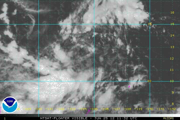
AN AREA OF CONVECTION HAS PERSISTED NEAR 11.8N 135.4E,
APPROXIMATELY 205 NM NORTHWEST OF YAP, FEDERATED STATES OF
MICRONESIA. ANIMATED MSI SHOWS THE SYSTEM HAS STEADILY CONSOLIDATED
AND DEEPENED AS A TUTT CELL TO THE NORTH CONTINUES TO ENHANCE
POLEWARD OUTFLOW. A 250101Z ASCAT SCATTEROMETRY PASS SHOWS A
WELL-DEFINED LOW LEVEL CIRCULATION CENTER EMBEDDED IN THE MONSOON
TROUGH. ULA INDICATES THE SYSTEM IS JUST SOUTHEAST OF A RIDGE AXIS
AND JUST SOUTH OF THE TUTT IN AN AREA OF LOW (05-10 KNOT) VWS.
ADDITIONALLY, THE RIDGE TO THE NORTHWEST IS PROMOTING A STEADY
SOUTHWESTWARD OUTFLOW. SURFACE OBSERVATIONS FROM YAP AND PALAU SHOW A
SURGE OF SOUTHWESTERLY WINDS FEEDING INTO THE LLCC. NUMERICAL MODELS
ARE COMING INTO AGREEMENT IN DEVELOPING THIS CYCLONE VERSUS THE
DISTURBANCE IN PARA 1.B.(1). MAXIMUM SUSTAINED SURFACE WINDS ARE
ESTIMATED AT 15 TO 20 KNOTS. MINIMUM SEA LEVEL PRESSURE IS ESTIMATED
TO BE NEAR 1006 MB. IN VIEW OF THE EXCELLENT ENVIRONMENTAL CONDITIONS
THAT IS EXPECTED TO PREVAIL OVER THE NEXT 24-48 HOURS, THE POTENTIAL
FOR THE DEVELOPMENT OF A SIGNIFICANT TROPICAL CYCLONE WITHIN THE NEXT
24 HOURS IS ELEVATED TO MEDIUM.
after a whole 3 mins, i was able to tell which is which lol...
0 likes
Remember, all of my post aren't official. For official warnings and discussions, Please refer to your local NWS products...
NWS for the Western Pacific
https://www.weather.gov/gum/
NWS for the Western Pacific
https://www.weather.gov/gum/
Re: WPAC: JMA TD / INVEST 94W

THE AREA OF CONVECTION PREVIOUSLY LOCATED NEAR 14.5N
129.5E, IS NOW LOCATED NEAR 15.0N 128.8E, APPROXIMATELY 450 NM EAST
OF MANILA, PHILIPPINES. ANIMATED MULTISPECTRAL SATELLITE IMAGERY
(MSI) SHOWS THE ASSOCIATED CONVECTION HAS WEAKENED AND BECOME
FRAGMENTED OVER THE PAST SIX HOURS. UPPER LEVEL ANALYSIS (ULA)
INDICATES THE CYCLONE IS JUST SOUTHWEST OF A TROPICAL UPPER
TROPOSPHERIC TROUGH (TUTT)THAT IS CAUSING SUBSIDENCE ON THE POLEWARD
SIDE OF THE SYSTEM. THIS IS EVIDENT ON ANIMATED WATER VAPOR IMAGERY.
ALTHOUGH, BASED ON THE ULA, THE VERTICAL WIND SHEAR (VWS) VALUES ARE
LOW (05-10 KNOTS) AND THERE IS SOME OUTFLOW TO THE SOUTHWEST, THE
SUBSIDENT EFFECT OF THE TUTT APPEARS TO BE MORE DOMINANT. THE MAXIMUM
SUSTAINED SURFACE WINDS ARE ESTIMATED AT 12 TO 17 KNOTS. MINIMUM SEA
LEVEL PRESSURE IS ESTIMATED TO BE NEAR 1007 MB. DUE TO THE
DETERIORATING CONDITIONS OF THE SYSTEM, THE POTENTIAL FOR THE
DEVELOPMENT OF A SIGNIFICANT TROPICAL CYCLONE WITHIN THE NEXT 24
HOURS IS DOWNGRADED TO LOW.
0 likes
Remember, all of my post aren't official. For official warnings and discussions, Please refer to your local NWS products...
NWS for the Western Pacific
https://www.weather.gov/gum/
NWS for the Western Pacific
https://www.weather.gov/gum/
Re: WPAC: INVEST 95W

euro has a very small storm about to hit hong kong! hard to tell if that is a typhoon or not...
0 likes
Remember, all of my post aren't official. For official warnings and discussions, Please refer to your local NWS products...
NWS for the Western Pacific
https://www.weather.gov/gum/
NWS for the Western Pacific
https://www.weather.gov/gum/
-
RobWESTPACWX
- WestPACMet
- Posts: 1616
- Joined: Fri Sep 17, 2010 2:26 am
- Location: Tokyo, Japan
- Contact:
Re: WPAC: JMA TD / INVEST 94W
I see what your saying Dexter.
Here is my latest video on this as well.
[youtube]http://www.youtube.com/watch?v=WCgrTM-DdJ8[/youtube]
Here is my latest video on this as well.
[youtube]http://www.youtube.com/watch?v=WCgrTM-DdJ8[/youtube]
0 likes
Satellites, Charts and Forecasting tools for East Asia at WESTERNPACIFICWEATHER.COM


-
Meow
Re:
senorpepr wrote:Okay... this may be messed up, but I'm merging the two topics and pressing on from there.
We'll call this Invest 94W/95W. Although 95W appears to be the Tropical Depression... things so rather confusing. Hopefully 94W will die off soon and the direction of this topic will focus on 95W.
Yes, the JTWC believes 94W is dead.
ABPW10 PGTW 252000
MSGID/GENADMIN/JOINT TYPHOON WRNCEN PEARL HARBOR HI//
SUBJ/SIGNIFICANT TROPICAL WEATHER ADVISORY FOR THE WESTERN AND
/SOUTH PACIFIC OCEANS REISSUED/252000Z-260600ZJUN2012//
REF/A/MSG/JOINT TYPHOON WRNCEN PEARL HARBOR HI/251651ZJUN2012//
AMPN/REF A IS A TROPICAL CYCLONE FORMATION ALERT//
RMKS/
1. WESTERN NORTH PACIFIC AREA (180 TO MALAY PENINSULA):
A. TROPICAL CYCLONE SUMMARY: NONE.
B. TROPICAL DISTURBANCE SUMMARY:
(1) THE AREA OF CONVECTION PREVIOUSLY LOCATED NEAR 15.0N
128.8E HAS DISSIPATED AND IS NO LONGER SUSPECT FOR THE DEVELOPMENT
OF A SIGNIFICANT TROPICAL CYCLONE IN THE NEXT 24 HOURS.
(2) THE AREA OF CONVECTION PREVIOUSLY LOCATED NEAR 11.8N
135.4E, IS NOW LOCATED NEAR 12.7N 134.2E, APPROXIMATELY 330 NM NORTH
OF PALAU. ANIMATED INFRARED SATELLITE IMAGERY DEPICTS AN ELONGATED
LOW-LEVEL CIRCULATION CENTER (LLCC) WITH FLARING DEEP CONVECTION
OVER THE LLCC AND A LARGE AREA OF DEEP CONVECTION OVER THE SOUTH
SEMI-CIRCLE. A 251335Z TRMM IMAGE INDICATES FORMATIVE CONVECTIVE
BANDING WRAPPING INTO THE DEVELOPING LLCC. A 251207Z ASCAT IMAGE
SHOWS AN ELONGATED CIRCULATION WITH 15 TO 20 KNOT WINDS. A SHIP
REPORT AT 25/12Z (200 NM NW OF CENTER) SUPPORTS THE 20 KNOT
INTENSITY ASSESSMENT WITH WINDS 080/19 KNOTS AND SLP NEAR 1006 MB.
UPPER-LEVEL ANALYSIS SHOWS THAT THE LLCC IS LOCATED JUST SOUTH OF
THE SUBTROPICAL RIDGE AXIS WITH WEAK VERTICAL WIND SHEAR AND STRONG
DIFFLUENCE ENHANCED BY A TUTT CELL NEAR 23N 137E. DYNAMIC MODEL
GUIDANCE INDICATES THAT THE SYSTEM WILL CONTINUE TO CONSOLIDATE AND
SHOULD DEVELOP INTO A TROPICAL DEPRESSION WITHIN THE NEXT 12-36
HOURS AS IT TRACKS WEST-NORTHWESTWARD TOWARD NORTHERN LUZON.
MAXIMUM SUSTAINED SURFACE WINDS ARE ESTIMATED AT 15 TO 20 KNOTS.
MINIMUM SEA LEVEL PRESSURE IS ESTIMATED TO BE NEAR 1005 MB. THE
POTENTIAL FOR THE DEVELOPMENT OF A SIGNIFICANT TROPICAL CYCLONE
WITHIN THE NEXT 24 HOURS IS UPGRADED TO HIGH. SEE REF A (WTPN21 PGTW
251700) FOR FURTHER DETAILS.
(3) NO OTHER SUSPECT AREAS.
2. SOUTH PACIFIC AREA (WEST COAST OF SOUTH AMERICA TO 135 EAST):
A. TROPICAL CYCLONE SUMMARY: NONE.
B. TROPICAL DISTURBANCE SUMMARY: NONE.
3. JUSTIFICATION FOR REISSUE: UPGRADED AREA IN PARAGRAPH 1.B.(2) TO
HIGH AND DISSIPATED AREA IN PARAGRAPH 1.B.(1).//
NNNN
0 likes
Who is online
Users browsing this forum: No registered users and 61 guests