WPAC: DOKSURI - Post-Tropical
Moderator: S2k Moderators
-
tolakram
- Admin

- Posts: 19165
- Age: 60
- Joined: Sun Aug 27, 2006 8:23 pm
- Location: Florence, KY (name is Mark)
WPAC: DOKSURI - Post-Tropical
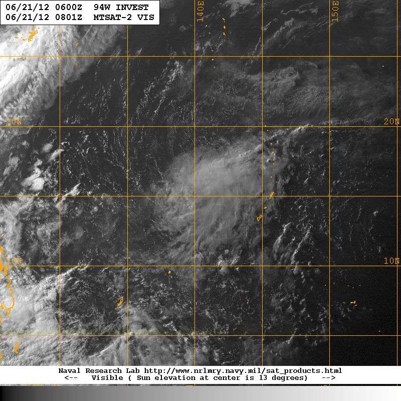
94W.INVEST, TRACK_VIS, 21 JUN 2012 1001Z
0 likes
M a r k
- - - - -
Join us in chat: Storm2K Chatroom Invite. Android and IOS apps also available.
The posts in this forum are NOT official forecasts and should not be used as such. Posts are NOT endorsed by any professional institution or STORM2K.org. For official information and forecasts, please refer to NHC and NWS products.

Re: WPAC: INVEST 94W

0 likes
Remember, all of my post aren't official. For official warnings and discussions, Please refer to your local NWS products...
NWS for the Western Pacific
https://www.weather.gov/gum/
NWS for the Western Pacific
https://www.weather.gov/gum/
-
dexterlabio
- Category 5

- Posts: 3407
- Joined: Sat Oct 24, 2009 11:50 pm
Re: WPAC: INVEST 94W
i don't know which is which now...but there's quite a chance that our next TC will come out of the invests we have in WPAC. Currently, Euro joins the pack showing a TC development east of PI, passing north of Luzon (Batanes)...extended run shows it hitting south of China (maybe HK?) as a weak system.

EURO 2300z


EURO 2300z
0 likes
Personal Forecast Disclaimer:
The posts in this forum are NOT official forecast and should not be used as such. They are just the opinion of the poster and may or may not be backed by sound meteorological data. They are NOT endorsed by any professional institution or storm2k.org. For official information, please refer to the NHC and NWS products.
The posts in this forum are NOT official forecast and should not be used as such. They are just the opinion of the poster and may or may not be backed by sound meteorological data. They are NOT endorsed by any professional institution or storm2k.org. For official information, please refer to the NHC and NWS products.
-
dexterlabio
- Category 5
- Posts: 3407
- Joined: Sat Oct 24, 2009 11:50 pm
Re: WPAC: INVEST 94W
NRL
94WINVEST.15kts-1010mb 12.8N-136.5E
JMA
LOW PRESSURE AREA 1008 HPA NEAR 13N 136E WEST SLOWLY.
....hmmm..
94WINVEST.15kts-1010mb 12.8N-136.5E
JMA
LOW PRESSURE AREA 1008 HPA NEAR 13N 136E WEST SLOWLY.
....hmmm..
0 likes
Personal Forecast Disclaimer:
The posts in this forum are NOT official forecast and should not be used as such. They are just the opinion of the poster and may or may not be backed by sound meteorological data. They are NOT endorsed by any professional institution or storm2k.org. For official information, please refer to the NHC and NWS products.
The posts in this forum are NOT official forecast and should not be used as such. They are just the opinion of the poster and may or may not be backed by sound meteorological data. They are NOT endorsed by any professional institution or storm2k.org. For official information, please refer to the NHC and NWS products.
Re: WPAC: INVEST 94W

vorticity increasing...

looks like our 7th tropical cyclone this season is imminent
0 likes
Remember, all of my post aren't official. For official warnings and discussions, Please refer to your local NWS products...
NWS for the Western Pacific
https://www.weather.gov/gum/
NWS for the Western Pacific
https://www.weather.gov/gum/
-
ManilaTC

- WesternPacificWeather.com

- Posts: 592
- Age: 45
- Joined: Mon Oct 26, 2009 5:13 am
- Location: Mandaluyong City, Philippines
- Contact:
Re: WPAC: INVEST 94W
94W is looking good now, convection has increased overnight.

here is the probability guidance

no clear passes on ASCAT imagery yet, maybe in a little while.

lastly, models now move it a tad closer to Northern Luzon.

here is the probability guidance
no clear passes on ASCAT imagery yet, maybe in a little while.
lastly, models now move it a tad closer to Northern Luzon.
0 likes
The above post is NOT official and should not be used as such. It is my opinion and may or may not be backed by sound meteorological data. It is not endorsed by any professional institution or storm2k.org. Please refer to your official national weather agency.
WEB http://goo.gl/JDiKXB | FB https://goo.gl/N5sIle | @ManilaTC
WEB http://goo.gl/JDiKXB | FB https://goo.gl/N5sIle | @ManilaTC
-
RobWESTPACWX
- WestPACMet

- Posts: 1616
- Joined: Fri Sep 17, 2010 2:26 am
- Location: Tokyo, Japan
- Contact:
-
dexterlabio
- Category 5
- Posts: 3407
- Joined: Sat Oct 24, 2009 11:50 pm
Latest run from Euro also shows a TD, almost the same with the 00z run. Quite interesting for me that they still see it SCS-bound heading towards HK...interesting in a way that for the past few years, no TC's make it to the SCS at this early point of the season, most storms forming in the Pacific tend to recurve towards Japan...last early SCS-bound storm I can remember is Chanchu in 2006.
0 likes
Personal Forecast Disclaimer:
The posts in this forum are NOT official forecast and should not be used as such. They are just the opinion of the poster and may or may not be backed by sound meteorological data. They are NOT endorsed by any professional institution or storm2k.org. For official information, please refer to the NHC and NWS products.
The posts in this forum are NOT official forecast and should not be used as such. They are just the opinion of the poster and may or may not be backed by sound meteorological data. They are NOT endorsed by any professional institution or storm2k.org. For official information, please refer to the NHC and NWS products.
Re: WPAC: INVEST 94W
interesting that euro shows *doksuri* strengthening in the south china sea and making landfall in hainan island/southern china...
0 likes
Remember, all of my post aren't official. For official warnings and discussions, Please refer to your local NWS products...
NWS for the Western Pacific
https://www.weather.gov/gum/
NWS for the Western Pacific
https://www.weather.gov/gum/
-
dexterlabio
- Category 5
- Posts: 3407
- Joined: Sat Oct 24, 2009 11:50 pm
Re: WPAC: INVEST 94W
Last GFS run now also shows a TC passing north of Luzon then heading towards China. (I have no idea what the solid yellow lines and red dashes indicate but I know a solid brown line indicates track of a weak undeveloped low.)

Still I'm more interested in Euro 2400z run. Gaahh I thought I would only be following Debby in the GOM this week.
Still I'm more interested in Euro 2400z run. Gaahh I thought I would only be following Debby in the GOM this week.
0 likes
Personal Forecast Disclaimer:
The posts in this forum are NOT official forecast and should not be used as such. They are just the opinion of the poster and may or may not be backed by sound meteorological data. They are NOT endorsed by any professional institution or storm2k.org. For official information, please refer to the NHC and NWS products.
The posts in this forum are NOT official forecast and should not be used as such. They are just the opinion of the poster and may or may not be backed by sound meteorological data. They are NOT endorsed by any professional institution or storm2k.org. For official information, please refer to the NHC and NWS products.
-
RobWESTPACWX
- WestPACMet
- Posts: 1616
- Joined: Fri Sep 17, 2010 2:26 am
- Location: Tokyo, Japan
- Contact:
Re: WPAC: INVEST 94W
Here are my thoughts on Invest 94W, I talk about it about half way through, the first part is about the rainy season front.
[youtube]http://www.youtube.com/watch?v=O5rEAK9gsfM[/youtube]
[youtube]http://www.youtube.com/watch?v=O5rEAK9gsfM[/youtube]
0 likes
Satellites, Charts and Forecasting tools for East Asia at WESTERNPACIFICWEATHER.COM
-
dexterlabio
- Category 5
- Posts: 3407
- Joined: Sat Oct 24, 2009 11:50 pm
Re: WPAC: INVEST 94W
i honestly get a lot of info about west pac weather by watching your vid updates, Rob. 
euro 00z pretty much the same. though we still have 3 days to verify. and in the parallel basin, people around GOM also have 3 days to see if which part of the gulf coast gets the storm.
euro 00z pretty much the same. though we still have 3 days to verify. and in the parallel basin, people around GOM also have 3 days to see if which part of the gulf coast gets the storm.
0 likes
Personal Forecast Disclaimer:
The posts in this forum are NOT official forecast and should not be used as such. They are just the opinion of the poster and may or may not be backed by sound meteorological data. They are NOT endorsed by any professional institution or storm2k.org. For official information, please refer to the NHC and NWS products.
The posts in this forum are NOT official forecast and should not be used as such. They are just the opinion of the poster and may or may not be backed by sound meteorological data. They are NOT endorsed by any professional institution or storm2k.org. For official information, please refer to the NHC and NWS products.
Re: WPAC: INVEST 94W

1. WESTERN NORTH PACIFIC AREA (180 TO MALAY PENINSULA):
A. TROPICAL CYCLONE SUMMARY: NONE.
B. TROPICAL DISTURBANCE SUMMARY:
(1) AN AREA OF CONVECTION HAS PERSISTED NEAR 9.5N 135.0E,
APPROXIMATELY 220 NM WEST OF YAP, FEDERATED STATES OF MICRONESIA.
ANIMATED INFRARED SATELLITE IMAGERY SHOWS FLARING CONVECTION AROUND A
BROAD LOW LEVEL CIRCULATION WITH ENHANCED POLEWARD OUTFLOW INTO A
TROPICAL UPPER TROPOSPHERIC TROUGH CELL TO THE NORTH. UPPER LEVEL
ANALYSIS INDICATES THE SYSTEM IS UNDERNEATH A RIDGE AXIS IN AN AREA
OF DIVERGENCE AND LIGHT (05-10 KNOT) VERTICAL WIND SHEAR. LOW LEVEL
STREAMLINE ANALYSIS INDICATES THE SYSTEM IS EMBEDDED IN A FRAGMENTED
EXTENSION OF THE MONSOON TROUGH. NUMERICAL MODELS, INCLUDING NOGAPS
AND GFS, ARE PROJECTING THE SYSTEM TO DEVELOP IN 2-3 DAYS AS IT
TRACKS ALONG THE SOUTHWEST PERIPHERY OF THE SUBTROPICAL RIDGE TO THE
NORTH. MAXIMUM SUSTAINED SURFACE WINDS ARE ESTIMATED AT 15 TO 20
KNOTS. MINIMUM SEA LEVEL PRESSURE IS ESTIMATED TO BE NEAR 1006 MB.
THE POTENTIAL FOR THE DEVELOPMENT OF A SIGNIFICANT TROPICAL CYCLONE
WITHIN THE NEXT 24 HOURS IS LOW.
slowly taking shape...
0 likes
Remember, all of my post aren't official. For official warnings and discussions, Please refer to your local NWS products...
NWS for the Western Pacific
https://www.weather.gov/gum/
NWS for the Western Pacific
https://www.weather.gov/gum/
-
ManilaTC
- WesternPacificWeather.com
- Posts: 592
- Age: 45
- Joined: Mon Oct 26, 2009 5:13 am
- Location: Mandaluyong City, Philippines
- Contact:
Now what?
JTWC is considering that blob east of Bicol now as 94W... Im going with PAGASA's call here two LPA's... where is the other one JTWC? they should have 2 invests hehe.
(1) THE AREA OF CONVECTION PREVIOUSLY LOCATED NEAR 9.5N
135.0E, IS NOW LOCATED NEAR 14.5N 129.5E, APPROXIMATELY 515 NM EAST
OF MANILA, PHILIPPINES. ANIMATED ENHANCED INFRARED SATELLITE IMAGERY
SHOWS CONVECTION HAS PERSISTED OVER THE PAST SIX HOURS IN THE
VICINITY OF A DEVELOPING LOW LEVEL CIRCULATION CENTER (LLCC). THE
LLCC REMAINED EMBEDDED WITHIN A LARGER TROUGH EXTENDING FROM THE
PHILIPPINES THROUGH YAP. UPPER LEVEL ANALYSIS INDICATES THE LLCC IS
LOCATED UNDER A REGION OF FAVORABLE DIVERGENCE WITH LOW VERTICAL
WIND SHEAR (05-10 KNOTS). SEA SURFACE TEMPERATURES REMAIN VERY
FAVORABLE (30 CELSIUS) WITHIN THE AREA SURROUNDING THE LLCC.
NUMERICAL MODEL GUIDANCE, INCLUDING NOGAPS AND GFS, INDICATE
DEVELOPMENT WITHIN THE NEXT FEW DAYS. MAXIMUM SUSTAINED SURFACE
WINDS ARE ESTIMATED AT 15 TO 20 KNOTS. MINIMUM SEA LEVEL PRESSURE IS
ESTIMATED TO BE NEAR 1006 MB. BASED ON AN IMPROVING ENVIRONMENT, YET
STILL LACKING ORGANIZATION, THE POTENTIAL FOR THE DEVELOPMENT OF A
SIGNIFICANT TROPICAL CYCLONE WITHIN THE NEXT 24 HOURS IS UPGRADED TO
MEDIUM.
0 likes
The above post is NOT official and should not be used as such. It is my opinion and may or may not be backed by sound meteorological data. It is not endorsed by any professional institution or storm2k.org. Please refer to your official national weather agency.
WEB http://goo.gl/JDiKXB | FB https://goo.gl/N5sIle | @ManilaTC
WEB http://goo.gl/JDiKXB | FB https://goo.gl/N5sIle | @ManilaTC
-
ManilaTC
- WesternPacificWeather.com
- Posts: 592
- Age: 45
- Joined: Mon Oct 26, 2009 5:13 am
- Location: Mandaluyong City, Philippines
- Contact:
Re: WPAC: INVEST 94W
From JMA's 0000 advisory
WWJP25 RJTD 250000
WARNING AND SUMMARY 250000.
WARNING VALID 260000.
WARNING IS UPDATED EVERY 6 HOURS.
GALE WARNING.
DEVELOPING LOW 1008 HPA
AT 33N 176E MIDWAYS MOVING NORTHEAST 10 KNOTS.
WINDS 30 TO 35 KNOTS WITHIN 300 MILES OF LOW.
WARNING.
DENSE FOG OBSERVED LOCALLY OVER SEA OF OKHOTSK SEA OF JAPAN YELLOW
SEA EAST CHINA SEA.
WARNING.
DENSE FOG OBSERVED LOCALLY OVER WATERS BOUNDED BY 38N 142E 41N 142E
45N 150E 60N 164E 60N 180E 60N 164E 60N 180E 39N 180E 40N 164E 38N
142E.
SUMMARY.
LOW 1004 HPA AT 33N 130E EAST 15 KT.
LOW 998 HPA AT 39N 155E ALMOST STATIONARY.
TROPICAL DEPRESSION 1008 HPA AT 11N 135E ALMOST STATIONARY.
HIGH 1020 HPA AT 56N 143E ALMOST STATIONARY.
HIGH 1018 HPA AT 49N 147E SW SLOWLY.
HIGH 1012 HPA AT 24N 149E ALMOST STATIONARY.
HIGH 1020 HPA AT 46N 176E ALMOST STATIONARY.
STATIONARY FRONT FROM 30N 117E TO 31N 124E 33N 130E 32N 134E 33N 139E
31N 147E.
0 likes
The above post is NOT official and should not be used as such. It is my opinion and may or may not be backed by sound meteorological data. It is not endorsed by any professional institution or storm2k.org. Please refer to your official national weather agency.
WEB http://goo.gl/JDiKXB | FB https://goo.gl/N5sIle | @ManilaTC
WEB http://goo.gl/JDiKXB | FB https://goo.gl/N5sIle | @ManilaTC
-
Typhoon Hunter
- WesternPacificWeather.com
- Posts: 1215
- Age: 40
- Joined: Wed Oct 11, 2006 11:37 am
- Location: Hong Kong
- Contact:
-
mrbagyo

- Category 5
- Posts: 3614
- Age: 31
- Joined: Thu Apr 12, 2012 9:18 am
- Location: 14.13N 120.98E
- Contact:
Re: WPAC: INVEST 94W
the blob in 135E is rotating and appears to be sucking the 4 cloud mass around it, this can help 94w's development. it will increase its size soon.
0 likes
The posts in this forum are NOT official forecast and should not be used as such. They are just the opinion of the poster and may or may not be backed by sound meteorological data. They are NOT endorsed by any professional institution or storm2k.org. For official information, please refer to RSMC, NHC and NWS products.
Re:
Typhoon Hunter wrote:Think JTWC have got slightly mixed up, I can see a furiously rotating blob at 135E, and little of interest at 129E. JMA got it covered as you highlighted above Clark!
wow! i saw that! a well defined rotating blob at 135 with a tutt cell to its north...looks like its developing quickly...let's watch which center wins out...this one or the one at 129...
0 likes
Remember, all of my post aren't official. For official warnings and discussions, Please refer to your local NWS products...
NWS for the Western Pacific
https://www.weather.gov/gum/
NWS for the Western Pacific
https://www.weather.gov/gum/
-
Typhoon Hunter
- WesternPacificWeather.com
- Posts: 1215
- Age: 40
- Joined: Wed Oct 11, 2006 11:37 am
- Location: Hong Kong
- Contact:
All a bit confusing, but Invest 95W is now being listed on NRL as the blob near 135E which is MEDIUM from JTWC and now a warned TD from JMA (a lot earlier than I was expecting from JMA):
WTPQ20 RJTD 250600
RSMC TROPICAL CYCLONE ADVISORY
NAME TD
ANALYSIS
PSTN 250600UTC 11.7N 134.8E FAIR
MOVE ALMOST STATIONARY
PRES 1006HPA
MXWD 030KT
GUST 045KT
FORECAST
24HF 260600UTC 11.9N 134.0E 120NM 70%
MOVE WNW SLOWLY
PRES 1004HPA
MXWD 035KT
GUST 050KT =
Should we just change the name of this thread to TD / Invest 95W since I think 94W is redundant? What do you guys reckon?
All models developing this and taking it towards N Luzon, Bashi or S Taiwan. ECMWF lands it right over Hong Kong on Saturday as a TS.
0 likes
-
Meow
Re:
Typhoon Hunter wrote:Should we just change the name of this thread to TD / Invest 95W since I think 94W is redundant? What do you guys reckon?
All models developing this and taking it towards N Luzon, Bashi or S Taiwan. ECMWF lands it right over Hong Kong on Saturday as a TS.
Why not split this topic into two, 94W and TD 95W (GW)?
0 likes
Who is online
Users browsing this forum: No registered users and 58 guests