WPAC: VICENTE - Post-Tropical
Moderator: S2k Moderators
-
RobWESTPACWX
- WestPACMet

- Posts: 1616
- Joined: Fri Sep 17, 2010 2:26 am
- Location: Tokyo, Japan
- Contact:
-
cycloneye

- Admin

- Posts: 139131
- Age: 67
- Joined: Thu Oct 10, 2002 10:54 am
- Location: San Juan, Puerto Rico
Re:
RobWESTPACWX wrote:Sadly James is on vacation in Thailand, poor guy chases storms and this one shows up on his door step and hes not there.
Oh ok. He would be all over this one.
0 likes
Visit the Caribbean-Central America Weather Thread where you can find at first post web cams,radars
and observations from Caribbean basin members Click Here
and observations from Caribbean basin members Click Here
-
RobWESTPACWX
- WestPACMet
- Posts: 1616
- Joined: Fri Sep 17, 2010 2:26 am
- Location: Tokyo, Japan
- Contact:
-
Meow

TY 1208 (VICENTE)
Issued at 12:45 UTC, 23 July 2012
<Analyses at 23/12 UTC>
Scale -
Intensity Strong
Center position N21°05'(21.1°)
E114°10'(114.2°)
Direction and speed of movement NW 15km/h(8kt)
Central pressure 970hPa
Maximum wind speed near the center 35m/s(65kt)
Maximum wind gust speed 50m/s(95kt)
Area of 50kt winds or more ALL150km(80NM)
Area of 30kt winds or more SE500km(270NM)
NW390km(210NM)
<Forecast for 24/00 UTC>
Intensity -
Center position of probability circle N22°10'(22.2°)
E112°25'(112.4°)
Direction and speed of movement WNW 20km/h(10kt)
Central pressure 975hPa
Maximum wind speed near the center 30m/s(60kt)
Maximum wind gust speed 45m/s(85kt)
Radius of probability circle 90km(50NM)
Storm warning area ALL200km(110NM)
<Forecast for 24/12 UTC>
Intensity -
Center position of probability circle N22°30'(22.5°)
E110°10'(110.2°)
Direction and speed of movement W 20km/h(10kt)
Central pressure 990hPa
Maximum sustained wind speed 20m/s(40kt)
Maximum wind gust speed 30m/s(60kt)
Radius of probability circle 140km(75NM)
<Forecast for 25/12 UTC>
Intensity -
TD
Center position of probability circle N22°20'(22.3°)
E106°30'(106.5°)
Direction and speed of movement W 15km/h(9kt)
Central pressure 998hPa
Radius of probability circle 200km(110NM)
0 likes
-
Meow

WTPN31 PGTW 231500
MSGID/GENADMIN/JOINT TYPHOON WRNCEN PEARL HARBOR HI//
SUBJ/TROPICAL CYCLONE WARNING//
RMKS/
1. TYPHOON 09W (VICENTE) WARNING NR 012
01 ACTIVE TROPICAL CYCLONE IN NORTHWESTPAC
MAX SUSTAINED WINDS BASED ON ONE-MINUTE AVERAGE
WIND RADII VALID OVER OPEN WATER ONLY
---
WARNING POSITION:
231200Z --- NEAR 21.0N 114.2E
MOVEMENT PAST SIX HOURS - 315 DEGREES AT 07 KTS
POSITION ACCURATE TO WITHIN 020 NM
POSITION BASED ON CENTER LOCATED BY SATELLITE
PRESENT WIND DISTRIBUTION:
MAX SUSTAINED WINDS - 070 KT, GUSTS 085 KT
WIND RADII VALID OVER OPEN WATER ONLY
RADIUS OF 064 KT WINDS - 015 NM NORTHEAST QUADRANT
015 NM SOUTHEAST QUADRANT
015 NM SOUTHWEST QUADRANT
015 NM NORTHWEST QUADRANT
RADIUS OF 050 KT WINDS - 040 NM NORTHEAST QUADRANT
040 NM SOUTHEAST QUADRANT
040 NM SOUTHWEST QUADRANT
040 NM NORTHWEST QUADRANT
RADIUS OF 034 KT WINDS - 105 NM NORTHEAST QUADRANT
090 NM SOUTHEAST QUADRANT
090 NM SOUTHWEST QUADRANT
085 NM NORTHWEST QUADRANT
REPEAT POSIT: 21.0N 114.2E
---
FORECASTS:
12 HRS, VALID AT:
240000Z --- 21.8N 112.5E
MAX SUSTAINED WINDS - 065 KT, GUSTS 080 KT
WIND RADII VALID OVER OPEN WATER ONLY
RADIUS OF 064 KT WINDS - 010 NM NORTHEAST QUADRANT
010 NM SOUTHEAST QUADRANT
010 NM SOUTHWEST QUADRANT
010 NM NORTHWEST QUADRANT
RADIUS OF 050 KT WINDS - 050 NM NORTHEAST QUADRANT
050 NM SOUTHEAST QUADRANT
050 NM SOUTHWEST QUADRANT
035 NM NORTHWEST QUADRANT
RADIUS OF 034 KT WINDS - 090 NM NORTHEAST QUADRANT
110 NM SOUTHEAST QUADRANT
095 NM SOUTHWEST QUADRANT
075 NM NORTHWEST QUADRANT
VECTOR TO 24 HR POSIT: 285 DEG/ 10 KTS
---
24 HRS, VALID AT:
241200Z --- 22.3N 110.3E
MAX SUSTAINED WINDS - 050 KT, GUSTS 065 KT
WIND RADII VALID OVER OPEN WATER ONLY
RADIUS OF 034 KT WINDS - 010 NM NORTHEAST QUADRANT
000 NM SOUTHEAST QUADRANT
005 NM SOUTHWEST QUADRANT
010 NM NORTHWEST QUADRANT
VECTOR TO 36 HR POSIT: 280 DEG/ 12 KTS
---
36 HRS, VALID AT:
250000Z --- 22.6N 107.8E
MAX SUSTAINED WINDS - 035 KT, GUSTS 045 KT
WIND RADII VALID OVER OPEN WATER ONLY
DISSIPATING AS A SIGNIFICANT TROPICAL CYCLONE OVER LAND
RADIUS OF 034 KT WINDS - 005 NM NORTHEAST QUADRANT
000 NM SOUTHEAST QUADRANT
000 NM SOUTHWEST QUADRANT
005 NM NORTHWEST QUADRANT
VECTOR TO 48 HR POSIT: 270 DEG/ 09 KTS
---
EXTENDED OUTLOOK:
48 HRS, VALID AT:
251200Z --- 22.6N 105.8E
MAX SUSTAINED WINDS - 030 KT, GUSTS 040 KT
WIND RADII VALID OVER OPEN WATER ONLY
DISSIPATING AS A SIGNIFICANT TROPICAL CYCLONE OVER LAND
VECTOR TO 72 HR POSIT: 265 DEG/ 06 KTS
---
72 HRS, VALID AT:
261200Z --- 22.3N 103.2E
MAX SUSTAINED WINDS - 020 KT, GUSTS 030 KT
WIND RADII VALID OVER OPEN WATER ONLY
DISSIPATED AS A SIGNIFICANT TROPICAL CYCLONE OVER LAND
---
REMARKS:
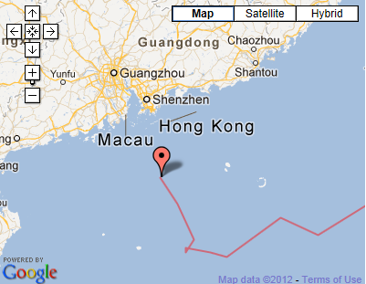
231500Z POSITION NEAR 21.2N 113.8E.
TYPHOON 09W (VICENTE), LOCATED APPROXIMATELY 80 NM SOUTH OF HONG
KONG, HAS TRACKED NORTHWESTWARD AT 07 KNOTS OVER THE PAST SIX HOURS.
MAXIMUM SIGNIFICANT WAVE HEIGHT AT 231200Z IS 22 FEET. NEXT WARNINGS
AT 232100Z, 240300Z, 240900Z AND 241500Z.//
NNNN
0 likes
-
Meow
-
RobWESTPACWX
- WestPACMet
- Posts: 1616
- Joined: Fri Sep 17, 2010 2:26 am
- Location: Tokyo, Japan
- Contact:
Re: WPAC: VICENTE - Typhoon
Here is my most recent video on this storm and what it is doing.
[youtube]http://www.youtube.com/watch?v=3hmKFXo9a8I[/youtube]
[youtube]http://www.youtube.com/watch?v=3hmKFXo9a8I[/youtube]
0 likes
Satellites, Charts and Forecasting tools for East Asia at WESTERNPACIFICWEATHER.COM

Re: WPAC: VICENTE - Typhoon
very dangerous wobble north to one of the most populated cities on the planet!

holy moly!
Last edited by euro6208 on Mon Jul 23, 2012 10:22 am, edited 2 times in total.
0 likes
Remember, all of my post aren't official. For official warnings and discussions, Please refer to your local NWS products...
NWS for the Western Pacific
https://www.weather.gov/gum/
NWS for the Western Pacific
https://www.weather.gov/gum/
Re: WPAC: VICENTE - Typhoon
Alert! recon needed...Alert!
0 likes
Remember, all of my post aren't official. For official warnings and discussions, Please refer to your local NWS products...
NWS for the Western Pacific
https://www.weather.gov/gum/
NWS for the Western Pacific
https://www.weather.gov/gum/
-
RobWESTPACWX
- WestPACMet
- Posts: 1616
- Joined: Fri Sep 17, 2010 2:26 am
- Location: Tokyo, Japan
- Contact:
Re: WPAC: VICENTE - Typhoon
CI# /Pressure/ Vmax
5.2 / 949.3mb/ 94.8kt
Final T# Adj T# Raw T#
5.2 6.0 6.3

rapidly intensifying!!!
Tno/CI Rules : Constraint Limits : 1.7T/6hr
Weakening Flag : OFF
Rapid Dissipation Flag : OFF
5.2 / 949.3mb/ 94.8kt
Final T# Adj T# Raw T#
5.2 6.0 6.3
rapidly intensifying!!!
Tno/CI Rules : Constraint Limits : 1.7T/6hr
Weakening Flag : OFF
Rapid Dissipation Flag : OFF
0 likes
Remember, all of my post aren't official. For official warnings and discussions, Please refer to your local NWS products...
NWS for the Western Pacific
https://www.weather.gov/gum/
NWS for the Western Pacific
https://www.weather.gov/gum/
-
RobWESTPACWX
- WestPACMet
- Posts: 1616
- Joined: Fri Sep 17, 2010 2:26 am
- Location: Tokyo, Japan
- Contact:
Re: WPAC: VICENTE - Typhoon
Wow, this global shot really puts it in to perspective.

0 likes
Satellites, Charts and Forecasting tools for East Asia at WESTERNPACIFICWEATHER.COM
-
RobWESTPACWX
- WestPACMet
- Posts: 1616
- Joined: Fri Sep 17, 2010 2:26 am
- Location: Tokyo, Japan
- Contact:
So what are the thoughts? Given information available what do you think the intensity is?
Im thinking personally maybe even a Cat 3.
Personal Forecast Disclaimer:
The posts in this forum are NOT official forecast and should not be used as such. They are just the opinion of the poster and may or may not be backed by sound meteorological data. They are NOT endorsed by any professional institution or storm2k.org. For official information, please refer to the NHC and NWS products.
0 likes
Satellites, Charts and Forecasting tools for East Asia at WESTERNPACIFICWEATHER.COM
Re: WPAC: VICENTE - Typhoon


intensity is at 115 knots category 4 strength typhoon.
where is everyone? makes me chuckle to see so few comments for a strong typhoon threatening lives. this isn't a *fish* storm...like they say...
The posts in this forum are NOT official forecast and should not be used as such. They are just the opinion of the poster and may or may not be backed by sound meteorological data. They are NOT endorsed by any professional institution or storm2k.org. For official information, please refer to the JTWC and JMA products.
0 likes
Remember, all of my post aren't official. For official warnings and discussions, Please refer to your local NWS products...
NWS for the Western Pacific
https://www.weather.gov/gum/
NWS for the Western Pacific
https://www.weather.gov/gum/
Re: WPAC: VICENTE - Typhoon
CI# /Pressure/ Vmax
5.5 / 943.6mb/102.0kt
Final T# Adj T# Raw T#
5.5 6.0 6.6
TPPN10 PGTW 231456
A. TYPHOON 09W (VICENTE)
B. 23/1432Z
C. 21.3N
D. 113.9E
E. ONE/MTSAT
F. T6.5/6.5/D3.5/24HRS STT: D0.5/03HRS
G. IR/EIR
H. REMARKS: 05A/PBO IRREG EYE/ANMTN. RI CAUSED T# TO BREAK
CONSTRAINTS, DEVELOPING 3.5 T #S IN 24 HR. OW EYE SURR BY DG
WITH COLDEST SHADE B YIELDS A 6.0 + .5 FOR A BANDING FEATURE
YIELDS A 6.5 DT. MET/PT AGREE. DBO DT.
I. ADDITIONAL POSITIONS:
23/1001Z 20.8N 114.5E SSMS
23/1003Z 20.9N 114.4E SSMS
23/1235Z 21.0N 114.3E SSMI
BELMONDO
already at category 4 ...can this make a run to category 5 at landfall?
Last edited by euro6208 on Mon Jul 23, 2012 10:52 am, edited 2 times in total.
0 likes
Remember, all of my post aren't official. For official warnings and discussions, Please refer to your local NWS products...
NWS for the Western Pacific
https://www.weather.gov/gum/
NWS for the Western Pacific
https://www.weather.gov/gum/

Re: WPAC: VICENTE - Typhoon
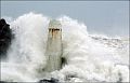
I live in Taipei, but happen to be in HK this week. This storm caught me by surprise as I thought it would stay well south of HK and never thought it would get this strong. Even late this morning the HKO was stating that raising the No. 8 Signal was unlikely. The winds are very strong right now (gusting to about 100 kph where I am, with much higher winds elsewhere) and sheets of rain are pouring down. Some trees are down in the area, and I can see some debris on the street below. Several ambulances and police cars with sirens have passed by and the news is already reporting injuries. The city is quiet now compared to a few hours ago when people were in a mad rush to get home before public transit stopped. Hope people heed the warnings to stay indoors.
ETA: HKO has raised Storm Signal No. 9.
ETA: HKO has raised Storm Signal No. 9.
0 likes
-
Meow
Re: WPAC: VICENTE - Typhoon
Amoygal wrote:ETA: HKO has raised Storm Signal No. 9.
The first Increasing Gale or Storm Signal, No. 9 since Typhoon Molave in 2009.
0 likes
-
cycloneye
- Admin
- Posts: 139131
- Age: 67
- Joined: Thu Oct 10, 2002 10:54 am
- Location: San Juan, Puerto Rico
Re: WPAC: VICENTE - Typhoon

0 likes
Visit the Caribbean-Central America Weather Thread where you can find at first post web cams,radars
and observations from Caribbean basin members Click Here
and observations from Caribbean basin members Click Here
-
dexterlabio
- Category 5

- Posts: 3407
- Joined: Sat Oct 24, 2009 11:50 pm
Re: WPAC: VICENTE - Typhoon
i never thought the disorganized TD that stayed in Luzon last weekend would become a threatening typhoon, and i also didn't think at first that it will affect HK. The last typhoon that brought high winds to HK was Nesat, if im not mistaken...
and yes i must agree, Vicente doesn't look like a Cat1 typhoon. a high-end Cat2 for this kind is already very, very conservative...
The posts in this forum are NOT official forecast and should not be used as such. They are just the opinion of the poster and may or may not be backed by sound meteorological data. They are NOT endorsed by any professional institution or storm2k.org.
0 likes
Personal Forecast Disclaimer:
The posts in this forum are NOT official forecast and should not be used as such. They are just the opinion of the poster and may or may not be backed by sound meteorological data. They are NOT endorsed by any professional institution or storm2k.org. For official information, please refer to the NHC and NWS products.
The posts in this forum are NOT official forecast and should not be used as such. They are just the opinion of the poster and may or may not be backed by sound meteorological data. They are NOT endorsed by any professional institution or storm2k.org. For official information, please refer to the NHC and NWS products.
Re: WPAC: VICENTE - Typhoon
CI# /Pressure/ Vmax
5.8 / 937.0mb/109.8kt
Final T# Adj T# Raw T#
5.8 6.1 6.4
now up to 5.8 with raw T at 6.4...
5.8 / 937.0mb/109.8kt
Final T# Adj T# Raw T#
5.8 6.1 6.4
now up to 5.8 with raw T at 6.4...
0 likes
Remember, all of my post aren't official. For official warnings and discussions, Please refer to your local NWS products...
NWS for the Western Pacific
https://www.weather.gov/gum/
NWS for the Western Pacific
https://www.weather.gov/gum/
Who is online
Users browsing this forum: No registered users and 61 guests