WPAC: SAOLA - Post-Tropical

Moderator: S2k Moderators

Message
Author
User avatar
euro6208
Category 5
Category 5
Posts: 18547
Joined: Mon Mar 08, 2004 7:50 pm
Location: Guam

Re: WPAC: SAOLA - Typhoon

#141 Postby euro6208 » Wed Aug 01, 2012 10:20 am

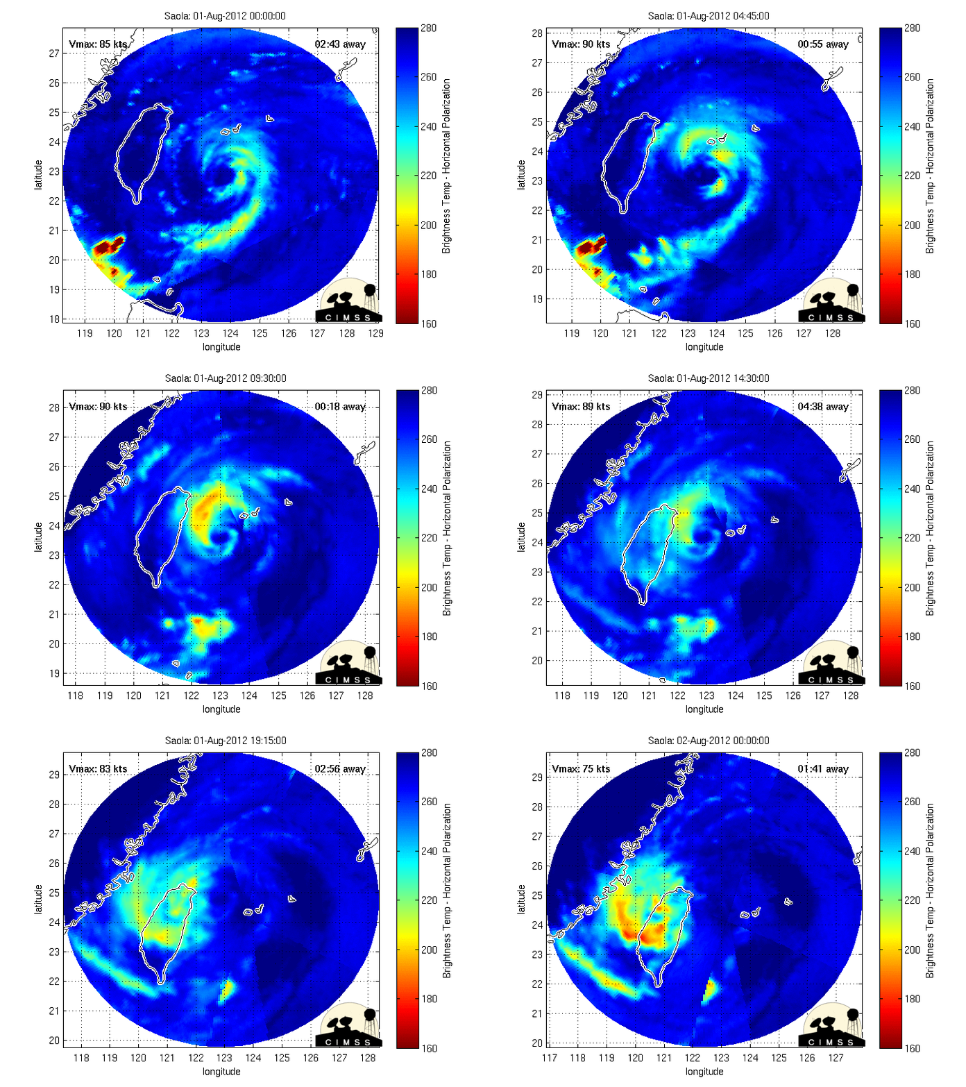
Typhoon Hunter, that is really an impressive radar imagery of Typhoon Saola...90 knots seems about right...very dangerous typhoon headed for taiwan which is already soaked and more flooding occuring...Taipei is in for a ride!

WTPN31 PGTW 011500
MSGID/GENADMIN/JOINT TYPHOON WRNCEN PEARL HARBOR HI//
SUBJ/TROPICAL CYCLONE WARNING//
RMKS/
1. TYPHOON 10W (SAOLA) WARNING NR 019
02 ACTIVE TROPICAL CYCLONES IN NORTHWESTPAC
MAX SUSTAINED WINDS BASED ON ONE-MINUTE AVERAGE
WIND RADII VALID OVER OPEN WATER ONLY
---
WARNING POSITION:
011200Z --- NEAR 24.0N 123.0E
MOVEMENT PAST SIX HOURS - 320 DEGREES AT 05 KTS
POSITION ACCURATE TO WITHIN 025 NM
POSITION BASED ON CENTER LOCATED BY SATELLITE
PRESENT WIND DISTRIBUTION:
MAX SUSTAINED WINDS - 090 KT, GUSTS 110 KT
WIND RADII VALID OVER OPEN WATER ONLY
RADIUS OF 064 KT WINDS - 030 NM NORTHEAST QUADRANT
040 NM SOUTHEAST QUADRANT
040 NM SOUTHWEST QUADRANT
030 NM NORTHWEST QUADRANT
RADIUS OF 050 KT WINDS - 060 NM NORTHEAST QUADRANT
065 NM SOUTHEAST QUADRANT
065 NM SOUTHWEST QUADRANT
055 NM NORTHWEST QUADRANT
RADIUS OF 034 KT WINDS - 140 NM NORTHEAST QUADRANT
135 NM SOUTHEAST QUADRANT
130 NM SOUTHWEST QUADRANT
140 NM NORTHWEST QUADRANT
REPEAT POSIT: 24.0N 123.0E
---
FORECASTS:
12 HRS, VALID AT:
020000Z --- 24.9N 122.3E
MAX SUSTAINED WINDS - 095 KT, GUSTS 115 KT
WIND RADII VALID OVER OPEN WATER ONLY
RADIUS OF 064 KT WINDS - 035 NM NORTHEAST QUADRANT
040 NM SOUTHEAST QUADRANT
040 NM SOUTHWEST QUADRANT
035 NM NORTHWEST QUADRANT
RADIUS OF 050 KT WINDS - 065 NM NORTHEAST QUADRANT
065 NM SOUTHEAST QUADRANT
065 NM SOUTHWEST QUADRANT
060 NM NORTHWEST QUADRANT
RADIUS OF 034 KT WINDS - 140 NM NORTHEAST QUADRANT
135 NM SOUTHEAST QUADRANT
130 NM SOUTHWEST QUADRANT
140 NM NORTHWEST QUADRANT
VECTOR TO 24 HR POSIT: 330 DEG/ 08 KTS
---
24 HRS, VALID AT:
021200Z --- 26.3N 121.4E
MAX SUSTAINED WINDS - 095 KT, GUSTS 115 KT
WIND RADII VALID OVER OPEN WATER ONLY
RADIUS OF 064 KT WINDS - 035 NM NORTHEAST QUADRANT
040 NM SOUTHEAST QUADRANT
040 NM SOUTHWEST QUADRANT
035 NM NORTHWEST QUADRANT
RADIUS OF 050 KT WINDS - 065 NM NORTHEAST QUADRANT
070 NM SOUTHEAST QUADRANT
065 NM SOUTHWEST QUADRANT
065 NM NORTHWEST QUADRANT
RADIUS OF 034 KT WINDS - 145 NM NORTHEAST QUADRANT
140 NM SOUTHEAST QUADRANT
135 NM SOUTHWEST QUADRANT
140 NM NORTHWEST QUADRANT
VECTOR TO 36 HR POSIT: 320 DEG/ 11 KTS
---
36 HRS, VALID AT:
030000Z --- 28.0N 119.8E
MAX SUSTAINED WINDS - 070 KT, GUSTS 085 KT
WIND RADII VALID OVER OPEN WATER ONLY
DISSIPATING AS A SIGNIFICANT TROPICAL CYCLONE OVER LAND
VECTOR TO 48 HR POSIT: 305 DEG/ 10 KTS
---
EXTENDED OUTLOOK:
48 HRS, VALID AT:
031200Z --- 29.1N 118.0E
MAX SUSTAINED WINDS - 040 KT, GUSTS 050 KT
WIND RADII VALID OVER OPEN WATER ONLY
DISSIPATING AS A SIGNIFICANT TROPICAL CYCLONE OVER LAND
VECTOR TO 72 HR POSIT: 290 DEG/ 07 KTS
---
72 HRS, VALID AT:
041200Z --- 30.1N 114.9E
MAX SUSTAINED WINDS - 020 KT, GUSTS 030 KT
WIND RADII VALID OVER OPEN WATER ONLY
DISSIPATED AS A SIGNIFICANT TROPICAL CYCLONE OVER LAND
---
REMARKS:
011500Z POSITION NEAR 24.2N 122.8E.
TYPHOON 10W (SAOLA), LOCATED APPROXIMATELY 100 NM SOUTHEAST OF
TAIPEI, TAIWAN, HAS TRACKED NORTHWESTWARD AT 05 KNOTS OVER THE
PAST SIX HOURS. MAXIMUM SIGNIFICANT WAVE HEIGHT AT 011200Z IS 37
FEET. NEXT WARNINGS AT 012100Z, 020300Z, 020900Z AND 021500Z. REFER
TO TYPHOON 11W (DAMREY) WARNINGS (WTPN32 PGTW) FOR SIX-HOURLY
UPDATES.//
NNNN

Image
0 likes   
Remember, all of my post aren't official. For official warnings and discussions, Please refer to your local NWS products...

NWS for the Western Pacific

https://www.weather.gov/gum/

User avatar
euro6208
Category 5
Category 5
Posts: 18547
Joined: Mon Mar 08, 2004 7:50 pm
Location: Guam

Re: WPAC: SAOLA - Typhoon

#142 Postby euro6208 » Wed Aug 01, 2012 10:26 am

Image

Image

WDPN31 PGTW 011500
MSGID/GENADMIN/JOINT TYPHOON WRNCEN PEARL HARBOR HI//
SUBJ/PROGNOSTIC REASONING FOR TYPHOON 10W (SAOLA) WARNING NR 19//
RMKS//
1. FOR METEOROLOGISTS.
2. 6 HOUR SUMMARY AND ANALYSIS.
TYPHOON 10W (SAOLA), LOCATED APPROXIMATELY 100 NM SOUTHEAST OF
TAIPEI, TAIWAN, HAS TRACKED NORTHWESTWARD AT 05 KNOTS OVER THE
PAST SIX HOURS. ANIMATED ENHANCED INFRARED SATELLITE IMAGERY SHOWS
COOLING CLOUD TOPS ASSOCIATED WITH BUILDING CONVECTION OVER THE
SOUTHERN PORTION OF THE LOW-LEVEL CIRCULATION CENTER (LLCC). THE
CURRENT POSITION IS BASED ON THE ABOVE MENTIONED IMAGERY WITH HIGH
CONFIDENCE. THE CURRENT INTENSITY IS BASED ON DVORAK ESTIMATES OF
90 KNOTS FROM PGTW, KNES, AND RJTD. UPPER-LEVEL ANALYSIS INDICATES
A POINT SOURCE OF DIVERGENCE DIRECTLY OVER THE SYSTEM WHICH IS
PROVIDING FOR WEAK (05-10 KNOTS) VERTICAL WIND SHEAR AND EXCELLENT
DIVERGENCE ALOFT. ANIMATED WATER VAPOR IMAGERY SHOWS ROBUST
EQUATORWARD OUTFLOW AND POLEWARD OUTFLOW CONTINUES TO SPREAD
NORTHWARD. INDUCED UPPER-LEVEL TROUGHING RESIDES IN BETWEEN THE
SYSTEM AND AN EXTENSION OF THE SUBTROPICAL RIDGE FURTHER TO THE
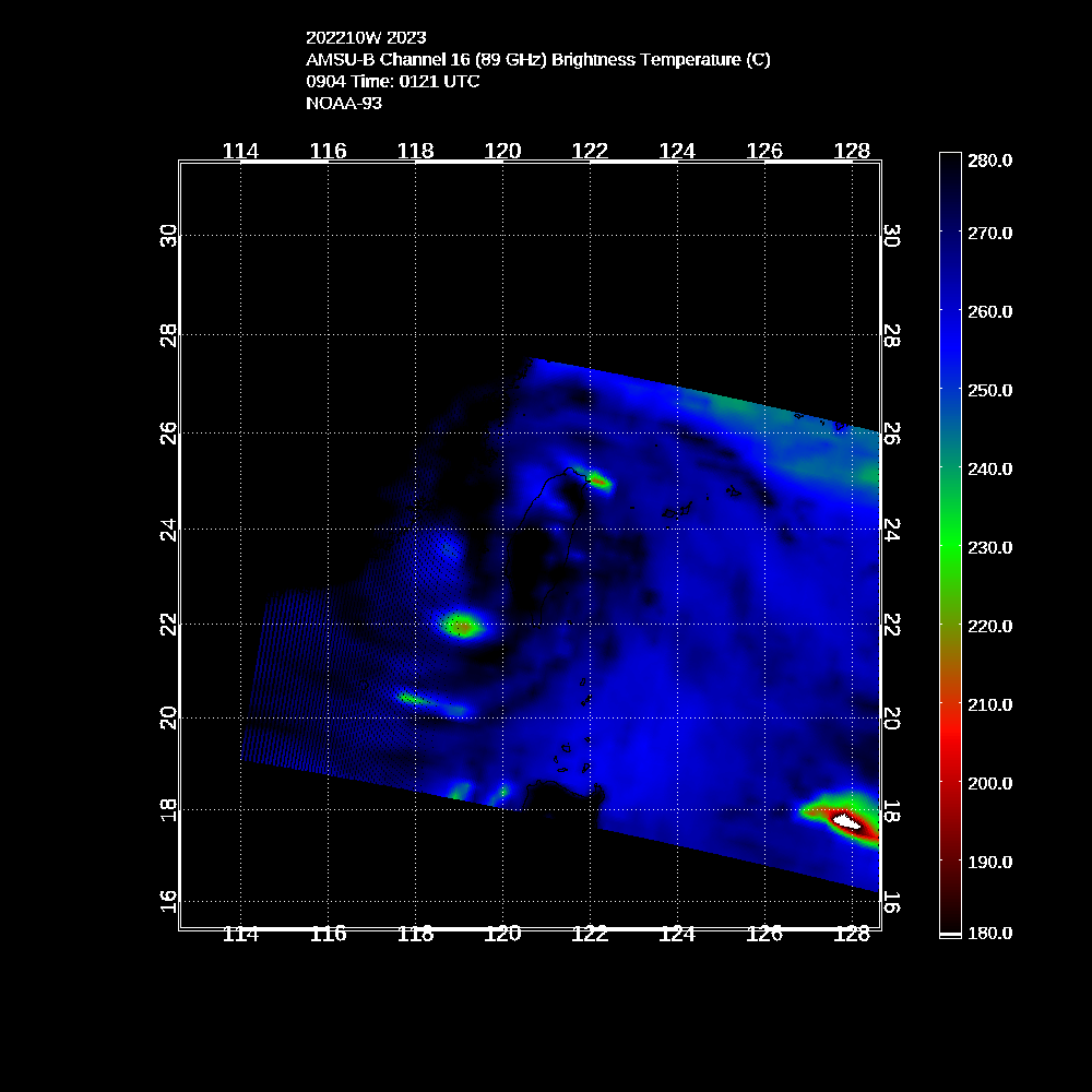
WEST. A 011246Z AMSU 89 GHZ IMAGES REVEALS THE DEEPEST CONVECTION
IS OVER THE SOUTHWESTERN QUADRANT OF THE LLCC. THIS ASYMMETRY IN
CONVECTION COMBINED WITH STRONG (60 KNOT) 500 MB SOUTHEASTERLY
FLOW, EVIDENT IN THE 011200Z ISHIGAKIJIMA SOUNDING, CAN ACCOUNT FOR
THE RECENT TRACK MOTION TOWARDS THE NORTHWEST. THIS SOUNDING, ALONG
WITH OTHERS IN THE AREA, CONFIRMS THAT TY 10W IS NOW STEERING ALONG
THE SOUTHWESTERN PERIPHERY OF THE BUILDING SUBTROPICAL RIDGE
CENTERED OVER JAPAN.
3. FORECAST REASONING.
A. THERE IS NO SIGNIFICANT CHANGE TO THE FORECAST PHILOSOPHY
FROM THE PREVIOUS PROGNOSTIC REASONING.
B. TY 10W IS FORECAST TO GRADUALLY INCREASE IN TRACK SPEED IN A
GENERAL NORTHWESTWARD DIRECTION UNDER THE INFLUENCE OF THE STR FOR
THE REMAINDER OF THE FORECAST PERIOD. INTENSIFICATION SHOULD
CONTINUE UNDER FAVORABLE UPPER-LEVEL AND SEA SURFACE CONDITIONS
ALLOWING TY 10W TO PEAK AT 95 KNOTS BY TAU 12. LANDFALL IS EXPECTED
BETWEEN TAUS 24 AND 36 AND GRADUAL DETERIORATION OF THE LLCC WILL
OCCUR THROUGH TAU 72 WHERE IT WILL HAVE DISSIPATED OVERLAND. MODEL
GUIDANCE IS TIGHTLY GROUPED UP TO LANDFALL WITH THE EXCEPTION OF
THE GFDN WHICH REMAINS THE RIGHT MOST OUTLIER. THE TRACK FORECAST
IS IN AGREEMENT WITH THE MODEL CONSENSUS UP TO TAU 36 WHERE IT THEN
REMAINS SLIGHTLY LEFT OF AND SLOWER TO OFFSET THE GFDN. THERE IS
HIGH CONFIDENCE IN THE TRACK FORECAST BASED ON THE TIGHT MODEL
ENVELOPE WHILE OVER WATER.//
NNNN

CI# /Pressure/ Vmax
5.5 / 933.8mb/102.0kt


Final T# Adj T# Raw T#
5.5 5.9 5.9

Image

Amazing...
0 likes   
Remember, all of my post aren't official. For official warnings and discussions, Please refer to your local NWS products...

NWS for the Western Pacific

https://www.weather.gov/gum/

User avatar
euro6208
Category 5
Category 5
Posts: 18547
Joined: Mon Mar 08, 2004 7:50 pm
Location: Guam

Re: WPAC: SAOLA - Typhoon

#143 Postby euro6208 » Wed Aug 01, 2012 11:10 am

Image

CI# /Pressure/ Vmax
5.6 / 931.6mb/104.6kt


Final T# Adj T# Raw T#
5.6 5.8 5.8
0 likes   
Remember, all of my post aren't official. For official warnings and discussions, Please refer to your local NWS products...

NWS for the Western Pacific

https://www.weather.gov/gum/

RobWESTPACWX
WestPACMet
WestPACMet
Posts: 1616
Joined: Fri Sep 17, 2010 2:26 am
Location: Tokyo, Japan
Contact:

Re: WPAC: SAOLA - Typhoon

#144 Postby RobWESTPACWX » Wed Aug 01, 2012 11:29 am

I just posted a video on Saola and also Damrey here.

[youtube]http://www.youtube.com/watch?v=FP6qtpm9tcA[/youtube]

Also here is Typhoon Hunters ( James ) Latest Video

[youtube]http://www.youtube.com/watch?v=7lejmAc59hU&feature=g-u-u[/youtube]
0 likes   
Satellites, Charts and Forecasting tools for East Asia at WESTERNPACIFICWEATHER.COM

User avatar
euro6208
Category 5
Category 5
Posts: 18547
Joined: Mon Mar 08, 2004 7:50 pm
Location: Guam

Re: WPAC: SAOLA - Typhoon

#145 Postby euro6208 » Wed Aug 01, 2012 12:14 pm

Image

Image

nearing landfall...

CI# /Pressure/ Vmax
5.7 / 929.4mb/107.2kt


Final T# Adj T# Raw T#
5.7 5.7 5.7
0 likes   
Remember, all of my post aren't official. For official warnings and discussions, Please refer to your local NWS products...

NWS for the Western Pacific

https://www.weather.gov/gum/

Meow

#146 Postby Meow » Wed Aug 01, 2012 12:36 pm

The eye is filled.

Image
0 likes   

User avatar
mrbagyo
Category 5
Category 5
Posts: 3614
Age: 31
Joined: Thu Apr 12, 2012 9:18 am
Location: 14.13N 120.98E
Contact:

Re: WPAC: SAOLA - Typhoon

#147 Postby mrbagyo » Wed Aug 01, 2012 12:44 pm

about to make landfall, looks like its carrying a lot of rain
0 likes   
The posts in this forum are NOT official forecast and should not be used as such. They are just the opinion of the poster and may or may not be backed by sound meteorological data. They are NOT endorsed by any professional institution or storm2k.org. For official information, please refer to RSMC, NHC and NWS products.

Meow

Re: WPAC: SAOLA - Typhoon

#148 Postby Meow » Wed Aug 01, 2012 12:56 pm

mrbagyo wrote:about to make landfall, looks like its carrying a lot of rain


Precipitation in Taipingshan since 31 July has reached over 1,300 millimetres.
0 likes   

User avatar
mrbagyo
Category 5
Category 5
Posts: 3614
Age: 31
Joined: Thu Apr 12, 2012 9:18 am
Location: 14.13N 120.98E
Contact:

Re: WPAC: SAOLA - Typhoon

#149 Postby mrbagyo » Wed Aug 01, 2012 1:20 pm

Meow wrote:
mrbagyo wrote:about to make landfall, looks like its carrying a lot of rain


Precipitation in Taipingshan since 31 July has reached over 1,300 millimetres.

is it as bad as morakot
0 likes   
The posts in this forum are NOT official forecast and should not be used as such. They are just the opinion of the poster and may or may not be backed by sound meteorological data. They are NOT endorsed by any professional institution or storm2k.org. For official information, please refer to RSMC, NHC and NWS products.

User avatar
Hurricane_Luis
Category 2
Category 2
Posts: 723
Age: 26
Joined: Sat Jun 23, 2012 3:14 pm
Location: Tiptree, Essex, United Kingdom
Contact:

#150 Postby Hurricane_Luis » Wed Aug 01, 2012 2:09 pm

how intense will saola get before it make landfall, will it make cat 3 strenght
0 likes   

Meow

Re:

#151 Postby Meow » Wed Aug 01, 2012 2:45 pm

Hurricane_Luis wrote:how intense will saola get before it make landfall, will it make cat 3 strenght


Well, it is 85 knots now from the NRL... As it is now near the coast of Hualien County, it is impossible to become a category 3 typhoon at all.
0 likes   

Meow

#152 Postby Meow » Wed Aug 01, 2012 2:48 pm

One word: Ridiculous

Image
0 likes   

Meow

#153 Postby Meow » Wed Aug 01, 2012 3:59 pm

The Central Weather Bureau (CWB) reported that Typhoon Saola made landfall over Xiulin, Hualien in Taiwan at 19:20 UTC on August 1 (03:20 TST on August 2).
0 likes   

User avatar
mrbagyo
Category 5
Category 5
Posts: 3614
Age: 31
Joined: Thu Apr 12, 2012 9:18 am
Location: 14.13N 120.98E
Contact:

Re: WPAC: SAOLA - Tropical Storm

#154 Postby mrbagyo » Wed Aug 01, 2012 4:11 pm

mrbagyo wrote:jtwc forecast this to slam the tall mountain ranges of Taiwan, might unleash "Morakot-ish" rainfall.


the size, the rainfall, the slow movement. a bit similar to Morakot,,, I hope the effects aren't as bad
0 likes   
The posts in this forum are NOT official forecast and should not be used as such. They are just the opinion of the poster and may or may not be backed by sound meteorological data. They are NOT endorsed by any professional institution or storm2k.org. For official information, please refer to RSMC, NHC and NWS products.

madness
Tropical Low
Tropical Low
Posts: 41
Joined: Sat Jul 30, 2011 11:23 pm
Location: Brisbane, Australia

Re: WPAC: SAOLA - Typhoon

#155 Postby madness » Wed Aug 01, 2012 8:16 pm

News article about Typhoon Saola and the impact on Taiwan
http://www.washingtonpost.com/world/asi ... story.html

Points of Interest:
Typhoon Saola, which killed at least 14 people in the Philippines, has already been blamed for four deaths in Taiwan, with the toll expected to rise.

Authorities ordered offices and businesses closed throughout northern Taiwan, including in Taipei. Normally busy streets in the capital were deserted during the morning rush hour, as cleanup crews labored to clear them of hundreds of trees and branches felled during the night by Saola’s ferocious approach.

Dozens of flights were canceled at Taipei’s main international airport, and rail transport throughout the island was disrupted.
0 likes   

whetherornot
Tropical Wave
Tropical Wave
Posts: 9
Joined: Tue May 31, 2011 8:30 pm
Location: Kaohsiung, Taiwan

Re: WPAC: SAOLA - Typhoon

#156 Postby whetherornot » Wed Aug 01, 2012 9:38 pm

So, now Taiwan is 'enjoying' a Typhoon Holiday and we clean up & check on neighbors, there remains only one question: How can (all) the models have the track so wrong? What happened to cause that abrupt left turn late last night?
0 likes   

madness
Tropical Low
Tropical Low
Posts: 41
Joined: Sat Jul 30, 2011 11:23 pm
Location: Brisbane, Australia

Re: WPAC: SAOLA - Typhoon

#157 Postby madness » Wed Aug 01, 2012 9:58 pm

whetherornot wrote:So, now Taiwan is 'enjoying' a Typhoon Holiday and we clean up & check on neighbors, there remains only one question: How can (all) the models have the track so wrong? What happened to cause that abrupt left turn late last night?


An excellent question and I do not have answers but I will state that this is the second major typhoon recently for which the models were wrong
Typhoon Vicente "bombed" and made landfall near Macau
0 likes   

phwxenthusiast
Category 2
Category 2
Posts: 637
Joined: Wed Mar 24, 2010 3:10 am
Location: Holbrook, NY (Long Island)

Re: WPAC: SAOLA - Typhoon

#158 Postby phwxenthusiast » Wed Aug 01, 2012 11:07 pm

whetherornot wrote:So, now Taiwan is 'enjoying' a Typhoon Holiday and we clean up & check on neighbors, there remains only one question: How can (all) the models have the track so wrong? What happened to cause that abrupt left turn late last night?


i believe the topography of Taiwan may have contributed to that wobble... i posted about two days ago how models were suggesting continuous formation of weak vortices west and southwest of Taiwan... this may have pulled in the system closer to the coast--clearly observed on radar last night.. we've seen this time and again how systems meander just east of Taiwan, and some even make loops as they interact with the island.. right now, the LLCC seems to have moved back to the ocean and should slowly begin to inch northwestward...

i believe lee cyclogenesis is the right term (?)

Personal Forecast Disclaimer:
The posts in this forum are NOT official forecast and should not be used as such. They are just the opinion of the poster and may or may not be backed by sound meteorological data. They are NOT endorsed by any professional institution or storm2k.org. For official information, please refer to the NHC and NWS products.
0 likes   

Meow

Re: WPAC: SAOLA - Severe Tropical Storm

#159 Postby Meow » Thu Aug 02, 2012 1:57 am

JMA: 50 knots

Image

STS 1209 (SAOLA)
Issued at 06:45 UTC, 2 August 2012

<Analyses at 02/06 UTC>
Scale Large
Intensity -
Center position N24°50'(24.8°)
E122°00'(122.0°)
Direction and speed of movement NNW 20km/h(10kt)
Central pressure 980hPa
Maximum sustained wind speed 25m/s(50kt)
Maximum wind gust speed 35m/s(70kt)
Area of 30kt winds or more ALL560km(300NM)

<Estimate for 02/07 UTC>
Scale Large
Intensity -
Center position N25°00'(25.0°)
E121°55'(121.9°)
Direction and speed of movement NNW 20km/h(10kt)
Central pressure 980hPa
Maximum sustained wind speed 25m/s(50kt)
Maximum wind gust speed 35m/s(70kt)
Area of 30kt winds or more ALL560km(300NM)

<Forecast for 02/12 UTC>
Intensity -
Center position of probability circle N25°50'(25.8°)
E121°35'(121.6°)
Direction and speed of movement NNW 20km/h(10kt)
Central pressure 980hPa
Maximum sustained wind speed 25m/s(50kt)
Maximum wind gust speed 35m/s(70kt)
Radius of probability circle 60km(30NM)

<Forecast for 02/18 UTC>
Intensity -
Center position of probability circle N26°40'(26.7°)
E121°05'(121.1°)
Direction and speed of movement NNW 20km/h(10kt)
Central pressure 980hPa
Maximum sustained wind speed 25m/s(50kt)
Maximum wind gust speed 35m/s(70kt)
Radius of probability circle 90km(50NM)

<Forecast for 03/00 UTC>
Intensity -
Center position of probability circle N27°40'(27.7°)
E120°25'(120.4°)
Direction and speed of movement NNW 20km/h(11kt)
Central pressure 980hPa
Maximum sustained wind speed 25m/s(50kt)
Maximum wind gust speed 35m/s(70kt)
Radius of probability circle 120km(65NM)

<Forecast for 03/06 UTC>
Intensity -
Center position of probability circle N28°50'(28.8°)
E119°30'(119.5°)
Direction and speed of movement NNW 20km/h(12kt)
Central pressure 992hPa
Maximum sustained wind speed 20m/s(40kt)
Maximum wind gust speed 30m/s(60kt)
Radius of probability circle 140km(75NM)
0 likes   

tim_in_ga
Tropical Storm
Tropical Storm
Posts: 125
Joined: Fri Jun 10, 2005 9:30 pm
Location: Buford, GA

Re: WPAC: SAOLA - Severe Tropical Storm

#160 Postby tim_in_ga » Thu Aug 02, 2012 5:42 am

Impressive amount of rainfall, even in central Taiwan. My in-laws in Taichung usually don't see much impact from typhoons but they got drenched. Highest rain total I have seen so far is 1,044mm in Taipingshan (太平山) in Yilan county. My retirement plan was to buy a house along the east coast of Taiwan somewhere but every year I lean more towards living on the other side of the mountains. Tough choice!

Image
0 likes   


Return to “2012”

Who is online

Users browsing this forum: No registered users and 106 guests