ATL: INVEST 98L
Moderator: S2k Moderators
-
MGC

- S2K Supporter

- Posts: 5792
- Joined: Sun Mar 23, 2003 9:05 pm
- Location: Pass Christian MS, or what is left.
Re: ATL: INVEST 98L
Needs a bit more deep convection to get named IMO.....I'm fine with all the high latitude systems....MGC
0 likes
-
cycloneye

- Admin

- Posts: 139086
- Age: 67
- Joined: Thu Oct 10, 2002 10:54 am
- Location: San Juan, Puerto Rico
Re: ATL: INVEST 98L
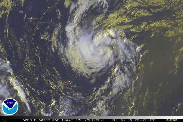
Remains at 40%.
TROPICAL WEATHER OUTLOOK
NWS NATIONAL HURRICANE CENTER MIAMI FL
800 PM EDT TUE JUL 24 2012
FOR THE NORTH ATLANTIC...CARIBBEAN SEA AND THE GULF OF MEXICO...
THUNDERSTORMS ASSOCIATED WITH A NON-TROPICAL LOW PRESSURE SYSTEM
LOCATED ABOUT 700 MILES EAST-NORTHEAST OF BERMUDA HAVE DIMINISHED.
THE LOW IS MOVING NORTHEASTWARD AT 15 TO 20 MPH MPH AND IS LIKELY
PRODUCING WINDS AT OR NEAR GALE FORCE. THIS SYSTEM HAS A MEDIUM
CHANCE...40 PERCENT...OF BECOMING A TROPICAL CYCLONE BEFORE IT
REACHES COOLER WATERS ON WEDNESDAY. FOR ADDITIONAL INFORMATION...
PLEASE SEE HIGH SEAS FORECASTS ISSUED BY THE NATIONAL WEATHER
SERVICE.
ELSEWHERE...TROPICAL CYCLONE FORMATION IS NOT EXPECTED DURING THE
NEXT 48 HOURS.
&&
HIGH SEAS FORECASTS CAN BE FOUND UNDER AWIPS HEADER NFDHSFAT1 AND
WMO HEADER FZNT01 KWBC.
$$
FORECASTER PASCH
0 likes
Visit the Caribbean-Central America Weather Thread where you can find at first post web cams,radars
and observations from Caribbean basin members Click Here
and observations from Caribbean basin members Click Here
-
ozonepete
- Professional-Met

- Posts: 4743
- Joined: Mon Sep 07, 2009 3:23 pm
- Location: From Ozone Park, NYC / Now in Brooklyn, NY
Re: ATL: INVEST 98L
I remember making the same argument about Chris: The symmetry was so good with Chris that it had a much stronger chance to get deep convection around the center. This one has even better symmetry than Chris did. Look at that perfect circle of the circulation envelope. That's why I think it has a pretty good shot at spinning up into a full TS before the cooler waters diminish its energy input.
0 likes
-
ozonepete
- Professional-Met
- Posts: 4743
- Joined: Mon Sep 07, 2009 3:23 pm
- Location: From Ozone Park, NYC / Now in Brooklyn, NY
Re: ATL: INVEST 98L
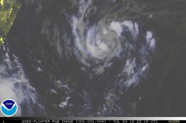
Latest. Would you call that a tropical disturbance or depression with that eye feature? "Eye feature" does not mean "eye" as we all know from frequent discussion here. What it means is that this tropical low has developed an eye-like feature with good symmetry. We will see how much convection develops near the center over the next 24 hours, but Chris had slightly less symmetry and became a hurricane over cooler water. Just sayin'...
0 likes
-
JonathanBelles
- Professional-Met
- Posts: 11430
- Age: 33
- Joined: Sat Dec 24, 2005 9:00 pm
- Location: School: Florida State University (Tallahassee, FL) Home: St. Petersburg, Florida
- Contact:
My thoughts on 98L, which I think will pull through overnight, but I am not sold on Ernesto. Also included are thoughts on the new tropical wave and SAL's impact on Florida.
http://jonathanbelles.wordpress.com/2012/07/24/547
http://jonathanbelles.wordpress.com/2012/07/24/547
0 likes
-
cycloneye
- Admin
- Posts: 139086
- Age: 67
- Joined: Thu Oct 10, 2002 10:54 am
- Location: San Juan, Puerto Rico
Re: ATL: INVEST 98L
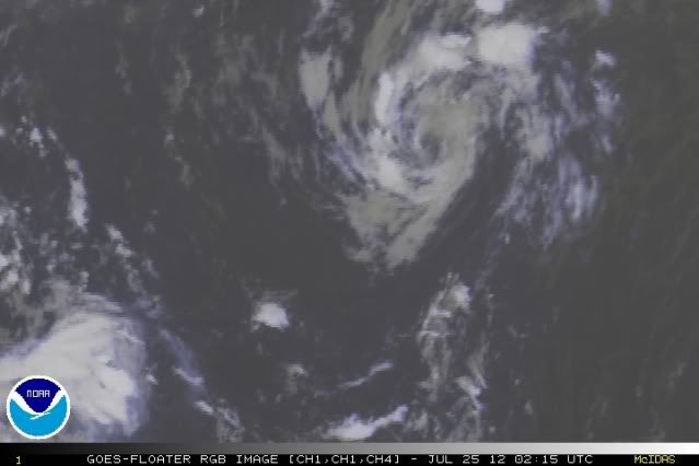
Bye to 98L.
TROPICAL WEATHER OUTLOOK
NWS NATIONAL HURRICANE CENTER MIAMI FL
800 AM EDT WED JUL 25 2012
FOR THE NORTH ATLANTIC...CARIBBEAN SEA AND THE GULF OF MEXICO...
THUNDERSTORM ACTIVITY REMAINS MINIMAL IN ASSOCIATION WITH A
NON-TROPICAL LOW PRESSURE SYSTEM LOCATED ABOUT 425 MILES
SOUTH-SOUTHEAST OF BERMUDA. THE LOW IS MOVING NORTHEASTWARD NEAR 20
MPH AND IS LIKELY PRODUCING WINDS TO NEAR GALE FORCE. THIS SYSTEM
HAS A LOW CHANCE...20 PERCENT...OF BECOMING A TROPICAL CYCLONE
BEFORE IT REACHES COOLER WATERS LATER TODAY. FOR ADDITIONAL
INFORMATION...PLEASE SEE HIGH SEAS FORECASTS ISSUED BY THE NATIONAL
WEATHER SERVICE.
ELSEWHERE...TROPICAL CYCLONE FORMATION IS NOT EXPECTED DURING THE
NEXT 48 HOURS.
&&
HIGH SEAS FORECASTS CAN BE FOUND UNDER AWIPS HEADER NFDHSFAT1 AND
WMO HEADER FZNT01 KWBC.
$$
FORECASTER STEWART
0 likes
Visit the Caribbean-Central America Weather Thread where you can find at first post web cams,radars
and observations from Caribbean basin members Click Here
and observations from Caribbean basin members Click Here
-
cycloneye
- Admin
- Posts: 139086
- Age: 67
- Joined: Thu Oct 10, 2002 10:54 am
- Location: San Juan, Puerto Rico
Re: ATL: INVEST 98L
Nothing new at 2 PM TWO from this morning's outlook.
TROPICAL WEATHER OUTLOOK
NWS NATIONAL HURRICANE CENTER MIAMI FL
200 PM EDT WED JUL 25 2012
FOR THE NORTH ATLANTIC...CARIBBEAN SEA AND THE GULF OF MEXICO...
THUNDERSTORM ACTIVITY HAS CHANGED LITTLE IN ASSOCIATION WITH A
NON-TROPICAL LOW PRESSURE SYSTEM LOCATED ABOUT 350 MILES SOUTHEAST
OF CAPE RACE NEWFOUNDLAND. THE LOW IS MOVING NORTHEASTWARD AT 25 TO
30 MPH AND IS LIKELY PRODUCING WINDS TO NEAR GALE FORCE. THIS
SYSTEM HAS A LOW CHANCE...20 PERCENT...OF BECOMING A TROPICAL
CYCLONE BEFORE IT REACHES COOLER WATERS LATER TODAY. FOR ADDITIONAL
INFORMATION...PLEASE SEE HIGH SEAS FORECASTS ISSUED BY THE NATIONAL
WEATHER SERVICE.
ELSEWHERE...TROPICAL CYCLONE FORMATION IS NOT EXPECTED DURING THE
NEXT 48 HOURS.
&&
HIGH SEAS FORECASTS CAN BE FOUND UNDER AWIPS HEADER NFDHSFAT1 AND
WMO HEADER FZNT01 KWBC.
$$
FORECASTER STEWART
0 likes
Visit the Caribbean-Central America Weather Thread where you can find at first post web cams,radars
and observations from Caribbean basin members Click Here
and observations from Caribbean basin members Click Here
-
cycloneye
- Admin
- Posts: 139086
- Age: 67
- Joined: Thu Oct 10, 2002 10:54 am
- Location: San Juan, Puerto Rico
Re: ATL: INVEST 98L
The following post is NOT an official forecast and should not be used as such. It is just the opinion of the poster and may or may not be backed by sound meteorological data. It is NOT endorsed by any professional institution including storm2k.org. For Official Information please refer to the NHC and NWS products.
Look at that. Does anyone think this system will be upgraded in post season? IMO,at least it has been with a very well defined circulation and almost all the time with convection,although it went almost away last night.
AL, 98, 2012072518, , BEST, 0, 438N, 494W, 45, 999, LO
ftp://ftp.nhc.noaa.gov/atcf/tcweb/inves ... 012.invest
0 likes
Visit the Caribbean-Central America Weather Thread where you can find at first post web cams,radars
and observations from Caribbean basin members Click Here
and observations from Caribbean basin members Click Here
-
Florida1118
- Category 5

- Posts: 1805
- Age: 27
- Joined: Sat Jun 19, 2010 12:57 pm
- Location: Tampa, Florida
Re: ATL: INVEST 98L
cycloneye wrote:Look at that. Does anyone think this system will be upgraded in post season? IMO,at least it has been with a very well defined circulation and almost all the time with convection,although it went almost away last night.
AL, 98, 2012072518, , BEST, 0, 438N, 494W, 45, 999, LO
ftp://ftp.nhc.noaa.gov/atcf/tcweb/inves ... 012.invest
I think its possible, but it really would only be for 6-12 hours. Im leaning more towards no since the convection wasn't sustained
Personal Forecast Disclaimer:
The posts in this forum are NOT official forecast and should not be used as such. They are just the opinion of the poster and may or may not be backed by sound meteorological data. They are NOT endorsed by any professional institution or storm2k.org. For official information, please refer to the NHC and NWS products.
0 likes
-
cycloneye
- Admin
- Posts: 139086
- Age: 67
- Joined: Thu Oct 10, 2002 10:54 am
- Location: San Juan, Puerto Rico
Re: ATL: INVEST 98L
TROPICAL WEATHER OUTLOOK
NWS NATIONAL HURRICANE CENTER MIAMI FL
800 PM EDT WED JUL 25 2012
FOR THE NORTH ATLANTIC...CARIBBEAN SEA AND THE GULF OF MEXICO...
THUNDERSTORM ACTIVITY HAS DIMINISHED IN ASSOCIATION WITH A NON-
TROPICAL LOW PRESSURE SYSTEM LOCATED ABOUT 230 MILES EAST OF CAPE
RACE NEWFOUNDLAND. THE LOW IS NOW MOVING RAPIDLY NORTH-
NORTHEASTWARD AT 30 TO 35 MPH OVER COLD WATERS...AND DEVELOPMENT IS
NOT EXPECTED. THIS SYSTEM HAS A LOW CHANCE...NEAR 0 PERCENT...OF
BECOMING A TROPICAL CYCLONE DURING THE NEXT 48 HOURS. FOR
ADDITIONAL INFORMATION...PLEASE SEE HIGH SEAS FORECASTS ISSUED BY
THE NATIONAL WEATHER SERVICE.
ELSEWHERE...TROPICAL CYCLONE FORMATION IS NOT EXPECTED DURING THE
NEXT 48 HOURS.
&&
HIGH SEAS FORECASTS CAN BE FOUND UNDER AWIPS HEADER NFDHSFAT1 AND
WMO HEADER FZNT01 KWBC.
$$
FORECASTER KIMBERLAIN
0 likes
Visit the Caribbean-Central America Weather Thread where you can find at first post web cams,radars
and observations from Caribbean basin members Click Here
and observations from Caribbean basin members Click Here
-
ozonepete
- Professional-Met
- Posts: 4743
- Joined: Mon Sep 07, 2009 3:23 pm
- Location: From Ozone Park, NYC / Now in Brooklyn, NY
Re: ATL: INVEST 98L
cycloneye wrote:The following post is NOT an official forecast and should not be used as such. It is just the opinion of the poster and may or may not be backed by sound meteorological data. It is NOT endorsed by any professional institution including storm2k.org. For Official Information please refer to the NHC and NWS products.
Look at that. Does anyone think this system will be upgraded in post season? IMO,at least it has been with a very well defined circulation and almost all the time with convection,although it went almost away last night.
AL, 98, 2012072518, , BEST, 0, 438N, 494W, 45, 999, LO
ftp://ftp.nhc.noaa.gov/atcf/tcweb/inves ... 012.invest
Good observation cycloneye. I'm pretty sure it will be, since it had the winds and the correct structure and it doesn't matter for how long it did in the end.
So how many possible post-season upgrades do we have now? I think it's 3, right?
Hope everyone inflated their forecast number of storms at the last minute when we submitted our forecasts for the pre-season poll, lol.
0 likes
-
hurricanes1234
- Category 5
- Posts: 2903
- Joined: Sat Jul 28, 2012 6:19 pm
- Location: Trinidad and Tobago
Re: ATL: INVEST 98L
This storm had everything a tropical cyclone needs - a well-defined circulation, wrapping rain bands, etc. I am still wondering why the NHC did not upgrade it to a TC. Maybe it will be in the post-tropical re-analysis.
0 likes
PLEASE NOTE: With the exception of information from weather agencies that I may copy and paste here, my posts will NEVER be official, since I am NOT a meteorologist. They are solely my amateur opinion, and may or may not be accurate. Therefore, please DO NOT use them as official details, particularly when making important decisions. Thank you.
Who is online
Users browsing this forum: No registered users and 113 guests