ATL: INVEST 90L - Discussion

Moderator: S2k Moderators

Message
Author
Aric Dunn
Category 5
Category 5
Posts: 21228
Age: 41
Joined: Sun Sep 19, 2004 9:58 pm
Location: Ready for the Chase.
Contact:

Re: ATL: INVEST 90L - Discussion

#121 Postby Aric Dunn » Thu Sep 06, 2012 12:03 pm

wxman57 wrote:
Aric Dunn wrote:
wxman57 wrote:Don't look for recon to provide much more information than we're already receiving from the numerous surface obs in the northern Gulf. Here's a GARP plot of surface obs/satellite. I identified the LLC with the red crosshairs (28.2N/88.5W). The nearest significant convection is about 100 miles to the SW. Surface winds are peaking out at 25 kts. Lacking any persistent (or any at all) convection near the center, it would not qualify for upgrade to a TD by the NHC's own standards.

Shear may drop off briefly on Saturday morning just before the increasing westerly winds aloft ahead of the cold front reach the disturbance. That would be its best window of opportunity to get convection over the center and perhaps become "Nadine" before it's taken apart by increasing shear.

[img]http://home.comcast.net/~cgh57/90La.gif[/ig]


This buoy recently just reported winds of 42kts. appears to be stronger than it looks. fairly high background pressures could be the reason for it.


http://www.ndbc.noaa.gov/station_page.php?station=42360


That's about 135nm SW of the LLC in that heavier convection. Still wouldn't qualify for upgrade based on the exposed center.

you as well as many have seen TD come from exposed centers ... its happened a couple times this year already. by definition it has closed circ and persistent convection no matter how from the center the convection is.
0 likes   
Note: If I make a post that is brief. Please refer back to previous posts for the analysis or reasoning. I do not re-write/qoute what my initial post said each time.
If there is nothing before... then just ask :)

Space & Atmospheric Physicist, Embry-Riddle Aeronautical University,
I believe the sky is falling...

User avatar
wxman57
Moderator-Pro Met
Moderator-Pro Met
Posts: 22482
Age: 66
Joined: Sat Jun 21, 2003 8:06 pm
Location: Houston, TX (southwest)

Re: ATL: INVEST 90L - Discussion

#122 Postby wxman57 » Thu Sep 06, 2012 12:04 pm

Convection has to persist over the center, not 130 miles away for qualification.
0 likes   

Aric Dunn
Category 5
Category 5
Posts: 21228
Age: 41
Joined: Sun Sep 19, 2004 9:58 pm
Location: Ready for the Chase.
Contact:

Re: ATL: INVEST 90L - Discussion

#123 Postby Aric Dunn » Thu Sep 06, 2012 12:06 pm

wxman57 wrote:Convection has to persist over the center, not 130 miles away for qualification.


well the tell the NHC that. its happened many times with exposed centers.

in general I agree.
0 likes   
Note: If I make a post that is brief. Please refer back to previous posts for the analysis or reasoning. I do not re-write/qoute what my initial post said each time.
If there is nothing before... then just ask :)

Space & Atmospheric Physicist, Embry-Riddle Aeronautical University,
I believe the sky is falling...

User avatar
SouthDadeFish
Professional-Met
Professional-Met
Posts: 2835
Joined: Thu Sep 23, 2010 2:54 pm
Location: Miami, FL
Contact:

Re: ATL: INVEST 90L - Discussion

#124 Postby SouthDadeFish » Thu Sep 06, 2012 12:08 pm

A Windsat pass at 12Z today shows a rather surprisingly somewhat organized structure. In this 37 GHz pass, the pinks are ice scattering, representing deep convection, while the cyan colors are warm rain. You can see spiral banding attempting to form, but the circulation is pretty elongated from SSW-NNE.

Image
0 likes   

WeatherGuesser
Category 5
Category 5
Posts: 2672
Joined: Tue Jun 29, 2010 6:46 am

Re: ATL: INVEST 90L - Discussion

#125 Postby WeatherGuesser » Thu Sep 06, 2012 12:29 pm

micktooth wrote:Good timing for the first big front! Here in Denver the high today will be 90 then the front comes through this evening, low tonight 49, and high tomorrow maybe only 70! This should definitely push anything that might develop out of the Gulf.


And that's supposed to cross the Mississippi sometime late Friday, so I'm not sure when that'll put it in play for the Gulf.
0 likes   

User avatar
wxman57
Moderator-Pro Met
Moderator-Pro Met
Posts: 22482
Age: 66
Joined: Sat Jun 21, 2003 8:06 pm
Location: Houston, TX (southwest)

Re: ATL: INVEST 90L - Discussion

#126 Postby wxman57 » Thu Sep 06, 2012 12:32 pm

Aric Dunn wrote:
wxman57 wrote:Convection has to persist over the center, not 130 miles away for qualification.


well the tell the NHC that. its happened many times with exposed centers.

in general I agree.


I listened to Jack Beven explain that at the AMS conference this past spring with respect to the unnamed system that hit Florida from the east last year. The low lacked persistent convection over the center - persistent as being defined by lasting at least 6-12 hours. That disturbance only had convection over the center for a few hours near landfall. That's why they never named it.

P.S. That was Invest 93L of Oct 6-13, 2011.
0 likes   

User avatar
wxman57
Moderator-Pro Met
Moderator-Pro Met
Posts: 22482
Age: 66
Joined: Sat Jun 21, 2003 8:06 pm
Location: Houston, TX (southwest)

Re: ATL: INVEST 90L - Discussion

#127 Postby wxman57 » Thu Sep 06, 2012 12:33 pm

WeatherGuesser wrote:
micktooth wrote:Good timing for the first big front! Here in Denver the high today will be 90 then the front comes through this evening, low tonight 49, and high tomorrow maybe only 70! This should definitely push anything that might develop out of the Gulf.


And that's supposed to cross the Mississippi sometime late Friday, so I'm not sure when that'll put it in play for the Gulf.


GFS has the leading edge of the front in the NE Gulf Saturday evening. Wind shear will be increasing ahead of the front, though.
0 likes   

DukeDevil91
S2K Supporter
S2K Supporter
Posts: 62
Joined: Thu Sep 08, 2011 4:04 pm

Re: ATL: INVEST 90L - Discussion

#128 Postby DukeDevil91 » Thu Sep 06, 2012 12:37 pm

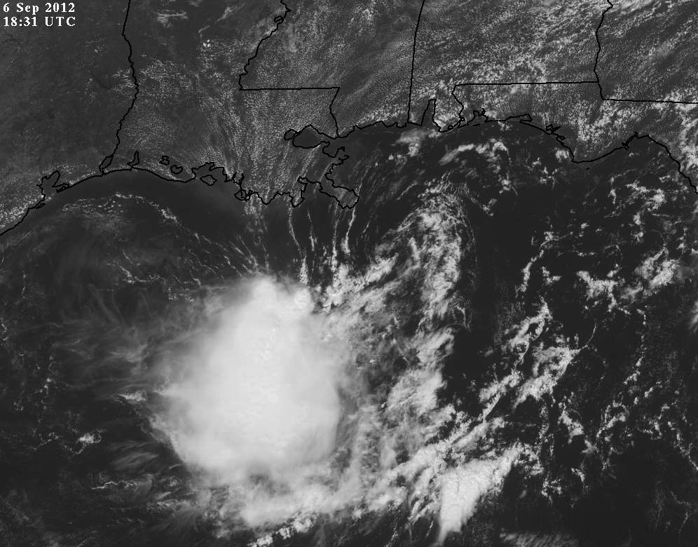
Visible showing a pretty well defined LLC at 28.2N 88.5W. Give it some convection and this a depression. Looks to be moving SW at this point. Anyone know what the northerly shear is supposed to do within the next 24 - 48 hours?
0 likes   

Aric Dunn
Category 5
Category 5
Posts: 21228
Age: 41
Joined: Sun Sep 19, 2004 9:58 pm
Location: Ready for the Chase.
Contact:

Re: ATL: INVEST 90L - Discussion

#129 Postby Aric Dunn » Thu Sep 06, 2012 12:48 pm

wxman57 wrote:
WeatherGuesser wrote:
micktooth wrote:Good timing for the first big front! Here in Denver the high today will be 90 then the front comes through this evening, low tonight 49, and high tomorrow maybe only 70! This should definitely push anything that might develop out of the Gulf.


And that's supposed to cross the Mississippi sometime late Friday, so I'm not sure when that'll put it in play for the Gulf.


GFS has the leading edge of the front in the NE Gulf Saturday evening. Wind shear will be increasing ahead of the front, though.


I agree that persistence is key, what is not always so cut a dry is when a system is producing persistent convection just not over the center. its a pretty fuzzy line some times and they have upgraded many times... as of right now I would not upgrade until the circ becomes more defined. The convective pattern is of a sheared system.
0 likes   
Note: If I make a post that is brief. Please refer back to previous posts for the analysis or reasoning. I do not re-write/qoute what my initial post said each time.
If there is nothing before... then just ask :)

Space & Atmospheric Physicist, Embry-Riddle Aeronautical University,
I believe the sky is falling...

User avatar
cycloneye
Admin
Admin
Posts: 139106
Age: 67
Joined: Thu Oct 10, 2002 10:54 am
Location: San Juan, Puerto Rico

Re: ATL: INVEST 90L - Discussion

#130 Postby cycloneye » Thu Sep 06, 2012 12:49 pm

2 PM TWO stays at 40%,Recon Postponed

AN ELONGATED AREA OF LOW PRESSURE CENTERED ABOUT 75 MILES SOUTHEAST
OF THE MOUTH OF THE MISSISSIPPI RIVER HAS BEEN DRIFTING SOUTHWARD
DURING THE PAST FEW HOURS. SINCE THE SHOWER ACTIVITY ASSOCIATED
WITH THE LOW REMAINS POORLY ORGANIZED...THE AIR FORCE
RECONNAISSANCE MISSION SCHEDULED FOR TODAY HAS BEEN POSTPONED TO
TOMORROW. THERE IS STILL POTENTIAL FOR SOME DEVELOPMENT DURING THE
NEXT DAY OR SO BEFORE ENVIRONMENTAL CONDITIONS BECOME UNFAVORABLE.
THIS WEATHER SYSTEM HAS A MEDIUM CHANCE...40 PERCENT...OF BECOMING
A TROPICAL CYCLONE DURING THE NEXT 48 HOURS.

0 likes   
Visit the Caribbean-Central America Weather Thread where you can find at first post web cams,radars
and observations from Caribbean basin members Click Here

Aric Dunn
Category 5
Category 5
Posts: 21228
Age: 41
Joined: Sun Sep 19, 2004 9:58 pm
Location: Ready for the Chase.
Contact:

#131 Postby Aric Dunn » Thu Sep 06, 2012 12:53 pm

interesting... I guess we wait. :)
0 likes   
Note: If I make a post that is brief. Please refer back to previous posts for the analysis or reasoning. I do not re-write/qoute what my initial post said each time.
If there is nothing before... then just ask :)

Space & Atmospheric Physicist, Embry-Riddle Aeronautical University,
I believe the sky is falling...

User avatar
GCANE
S2K Supporter
S2K Supporter
Posts: 10787
Joined: Mon Oct 22, 2007 8:03 am

Re: ATL: INVEST 90L - Discussion

#132 Postby GCANE » Thu Sep 06, 2012 1:03 pm

0 likes   

User avatar
wxman57
Moderator-Pro Met
Moderator-Pro Met
Posts: 22482
Age: 66
Joined: Sat Jun 21, 2003 8:06 pm
Location: Houston, TX (southwest)

Re: ATL: INVEST 90L - Discussion

#133 Postby wxman57 » Thu Sep 06, 2012 1:05 pm

0 likes   

otowntiger
Category 5
Category 5
Posts: 1787
Joined: Tue Aug 31, 2004 7:06 pm
Location: Orlando

Re: ATL: INVEST 90L - Discussion

#134 Postby otowntiger » Thu Sep 06, 2012 1:11 pm

wxman57 wrote:It doesn't appear to qualify for TD status now. I didn't see the center tucking under the convection in that satellite loop, by the way. It did look like the LLC may have weakened/opened up a bit on that loop, though. Pressures are actually 2mb higher in the area since yesterday. I think we have a high probability of a weak/sheared TD/TS in the NE Gulf tomorrow/Saturday tracking across the FL Peninsula on Sunday as it merges with the front. Should be relatively fast-moving across Florida, meaning less of a rain threat and no wind threat.
Thanks. So my fancy Davis weather station anemometer still won't be getting a work out. :( I've had the thing for 3 years and the strongest wind recorded so far (not applied by a a leaf blower :P ) was in a fast moving squall from Isaac last Monday: a whopping 38 mph! So I'm guessing this system will be even more tame for us here.
0 likes   

Aric Dunn
Category 5
Category 5
Posts: 21228
Age: 41
Joined: Sun Sep 19, 2004 9:58 pm
Location: Ready for the Chase.
Contact:

Re: ATL: INVEST 90L - Discussion

#135 Postby Aric Dunn » Thu Sep 06, 2012 1:15 pm


yep the convection has passed to its south.
0 likes   
Note: If I make a post that is brief. Please refer back to previous posts for the analysis or reasoning. I do not re-write/qoute what my initial post said each time.
If there is nothing before... then just ask :)

Space & Atmospheric Physicist, Embry-Riddle Aeronautical University,
I believe the sky is falling...

User avatar
CalmBeforeStorm
Category 2
Category 2
Posts: 600
Age: 70
Joined: Tue Aug 10, 2004 7:55 pm
Location: Stuart, Florida

#136 Postby CalmBeforeStorm » Thu Sep 06, 2012 1:25 pm

This is a sheared, naked swirl that has at most two days to organize before it is sheared apart and swept away by the approaching cold front. Not of much interest.
0 likes   

otowntiger
Category 5
Category 5
Posts: 1787
Joined: Tue Aug 31, 2004 7:06 pm
Location: Orlando

Re:

#137 Postby otowntiger » Thu Sep 06, 2012 1:42 pm

CalmBeforeStorm wrote:This is a sheared, naked swirl that has at most two days to organize before it is sheared apart and swept away by the approaching cold front. Not of much interest.
So far I agree. Of course every system has to come from somewhere so you never know. 2 days could be plenty of time if the conditions are right. Although I don't think they will be conducive enough and/or long enough for there to be much worry.
0 likes   

tolakram
Admin
Admin
Posts: 19165
Age: 60
Joined: Sun Aug 27, 2006 8:23 pm
Location: Florence, KY (name is Mark)

Re: ATL: INVEST 90L - Discussion

#138 Postby tolakram » Thu Sep 06, 2012 1:44 pm

Latest:

Image
0 likes   
M a r k
- - - - -
Join us in chat: Storm2K Chatroom Invite. Android and IOS apps also available.

The posts in this forum are NOT official forecasts and should not be used as such. Posts are NOT endorsed by any professional institution or STORM2K.org. For official information and forecasts, please refer to NHC and NWS products.

User avatar
ROCK
Category 5
Category 5
Posts: 9254
Age: 53
Joined: Tue Aug 17, 2004 7:30 am
Location: Kemah, Texas

Re: ATL: INVEST 90L - Discussion

#139 Postby ROCK » Thu Sep 06, 2012 2:11 pm

exposed....decapitated..naked... wont be much left if it doesnt fire off some more convection soon.....
0 likes   

User avatar
wxman57
Moderator-Pro Met
Moderator-Pro Met
Posts: 22482
Age: 66
Joined: Sat Jun 21, 2003 8:06 pm
Location: Houston, TX (southwest)

Re: ATL: INVEST 90L - Discussion

#140 Postby wxman57 » Thu Sep 06, 2012 2:59 pm

ROCK wrote:exposed....decapitated..naked... wont be much left if it doesnt fire off some more convection soon.....


Yes, convection is further separating from the LLC. No upgrade today. Shear just too strong. That's good. Don't need any more Gulf action this year.
0 likes   


Return to “2012”

Who is online

Users browsing this forum: No registered users and 40 guests