
[quote="ROCK"]exposed....decapitated..naked... wont be much left if it doesnt fire off some more convection soon.....[/quote]
Totally agree. IMO 90L will max out as a Tropical Depression. Too much working against it...
ATL: INVEST 90L - Discussion
Moderator: S2k Moderators
Re: ATL: INVEST 90L - Discussion
0 likes

Re: ATL: INVEST 90L - Discussion
I'm not entirely sure. I think it *may* make it to just barely TS strength, but that's about it.
0 likes
-
otowntiger
- Category 5

- Posts: 1787
- Joined: Tue Aug 31, 2004 7:06 pm
- Location: Orlando
Re: ATL: INVEST 90L - Discussion
Agreed. We're doing pretty good here in Central FL as far as rain goes too. Although we're still running a deficit and lakes ponds and wetlands are still low we've had our normal rain for he summer and we are certainly not in danger of rampant wild fires of the last couple seasons.wxman57 wrote:ROCK wrote:exposed....decapitated..naked... wont be much left if it doesnt fire off some more convection soon.....
Yes, convection is further separating from the LLC. No upgrade today. Shear just too strong. That's good. Don't need any more Gulf action this year.
0 likes
-
HurricaneAndrew92

-
Anthysteg00
- Tropical Low

- Posts: 38
- Joined: Mon Aug 27, 2012 5:50 pm
Re: ATL: INVEST 90L - Discussion
This cold front sure doesn't look very impressive either....appears zonal even. I'm not so convinced this will be as strong a front as predicted ...
0 likes
-
SouthFloridawx

- S2K Supporter

- Posts: 8344
- Age: 45
- Joined: Tue Jul 26, 2005 1:16 am
- Location: Sarasota, FL
- Contact:
-
otowntiger
- Category 5
- Posts: 1787
- Joined: Tue Aug 31, 2004 7:06 pm
- Location: Orlando
Re:
Welp, that's it then. If JB isn't even tweeting about it then it's dead for sure.rainstorm wrote:JB isnt even tweeting about it anymore
0 likes
-
MGC

- S2K Supporter
- Posts: 5792
- Joined: Sun Mar 23, 2003 9:05 pm
- Location: Pass Christian MS, or what is left.
Re: ATL: INVEST 90L - Discussion
Looked much better this morning....looks rather naked right now....but, things can change quickly in the tropics...MGC
0 likes
-
HurricaneAndrew92
Re: ATL: INVEST 90L - Discussion
A good graphic showing whats happening now. Red circle is center.


0 likes

Re: ATL: INVEST 90L - Discussion
Looks like a system lacking moisture more than a sheared system, pretty dry air all along the north central gulf coast, check the pw's mostly below 2.0 and very dry air aloft, which has been a problem for most of the Atlantic tropics this year.(thankfully)
0 likes
The following post is NOT an official forecast and should not be used as such. It is just the opinion of the poster and may or may not be backed by sound meteorological data. It is NOT endorsed by any professional institution including storm2k.org For Official Information please refer to the NHC and NWS products.
-
tolakram
- Admin

- Posts: 19165
- Age: 60
- Joined: Sun Aug 27, 2006 8:23 pm
- Location: Florence, KY (name is Mark)
Re: ATL: INVEST 90L - Discussion
HurricaneAndrew92 wrote:A good graphic showing whats happening now. Red circle is center.
http://img696.imageshack.us/img696/1213/90ld.jpg
Actually the shear is coming from the N/NE blowing to the S/SW.
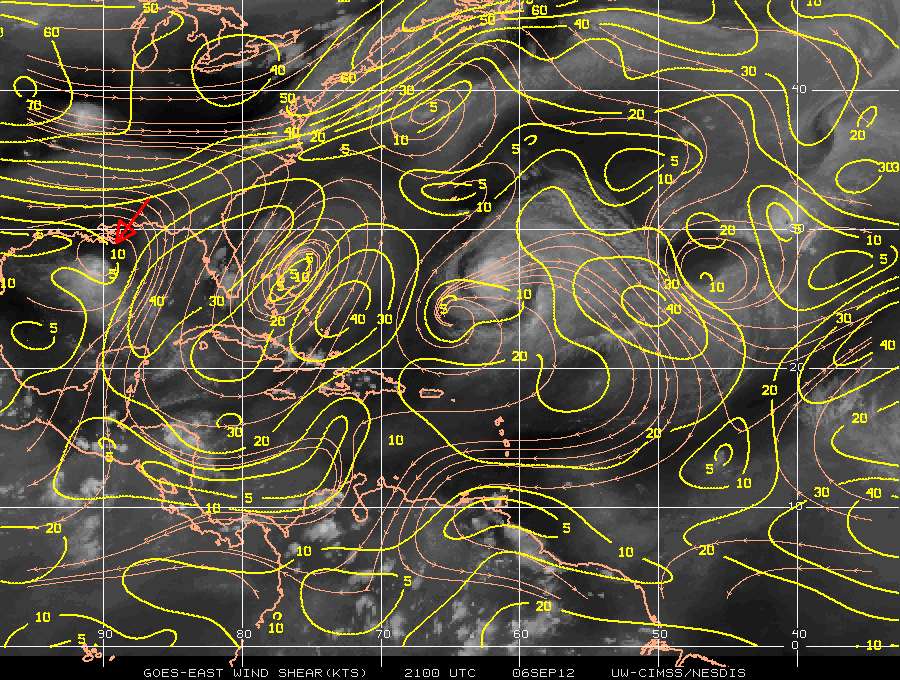
Live Loop: http://wwwghcc.msfc.nasa.gov/cgi-bin/ge ... umframes=5
0 likes
M a r k
- - - - -
Join us in chat: Storm2K Chatroom Invite. Android and IOS apps also available.
The posts in this forum are NOT official forecasts and should not be used as such. Posts are NOT endorsed by any professional institution or STORM2K.org. For official information and forecasts, please refer to NHC and NWS products.
-
rainstorm

Re: ATL: INVEST 90L - Discussion
wxman57 wrote:ROCK wrote:exposed....decapitated..naked... wont be much left if it doesnt fire off some more convection soon.....
Yes, convection is further separating from the LLC. No upgrade today. Shear just too strong. That's good. Don't need any more Gulf action this year.
oh the GOM has one more in her for this year....give it a week...
0 likes
Re: ATL: INVEST 90L - Discussion
http://www.ssd.noaa.gov/PS/TROP/floater ... -long.html
best naked swirl I have seen all year....if another LLC doesnt drill down under whats left of the MLC, 90L is dead, Jim...
best naked swirl I have seen all year....if another LLC doesnt drill down under whats left of the MLC, 90L is dead, Jim...
0 likes
-
tropicwatch

- Category 5
- Posts: 3205
- Age: 60
- Joined: Sat Jun 02, 2007 10:01 am
- Location: Panama City Florida
- Contact:
The circulation is quite evident in satellite loops. Very impressive but no support.
0 likes
Tropicwatch
Agnes 72', Eloise 75, Elena 85', Kate 85', Charley 86', Florence 88', Beryl 94', Dean 95', Erin 95', Opal 95', Earl 98', Georges 98', Ivan 2004', Arlene 2005', Dennis 2005', Ida 2009' Debby 2012' Irma 2017' Michael 2018'
Agnes 72', Eloise 75, Elena 85', Kate 85', Charley 86', Florence 88', Beryl 94', Dean 95', Erin 95', Opal 95', Earl 98', Georges 98', Ivan 2004', Arlene 2005', Dennis 2005', Ida 2009' Debby 2012' Irma 2017' Michael 2018'
-
cycloneye

- Admin
- Posts: 139115
- Age: 67
- Joined: Thu Oct 10, 2002 10:54 am
- Location: San Juan, Puerto Rico
Re: ATL: INVEST 90L - Discussion
Down to 30%
TROPICAL WEATHER OUTLOOK
NWS NATIONAL HURRICANE CENTER MIAMI FL
800 PM EDT THU SEP 6 2012
FOR THE NORTH ATLANTIC...CARIBBEAN SEA AND THE GULF OF MEXICO...
THE NATIONAL HURRICANE CENTER IS ISSUING ADVISORIES ON HURRICANE
LESLIE...LOCATED ABOUT 430 MILES SOUTH-SOUTHEAST OF BERMUDA...AND
ON HURRICANE MICHAEL...LOCATED ABOUT 945 MILES WEST-SOUTHWEST
OF THE AZORES.
A NEARLY STATIONARY AREA OF LOW PRESSURE IS CENTERED ABOUT 60 MILES
SOUTHEAST OF THE MOUTH OF THE MISSISSIPPI RIVER. THE ASSOCIATED
SHOWER AND THUNDERSTORM ACTIVITY IS LOCATED WELL TO THE SOUTHWEST
OF THE CENTER OF CIRCULATION DUE TO STRONG UPPER-LEVEL WINDS AND
DRY AIR. ENVIRONMENTAL CONDITIONS ARE NOT FORECAST TO BECOME
SIGNIFICANTLY MORE FAVORABLE...BUT THERE IS STILL SOME POTENTIAL
FOR THIS SYSTEM TO DEVELOP DURING THE NEXT COUPLE OF DAYS. THE LOW
HAS A MEDIUM CHANCE...30 PERCENT...OF BECOMING A TROPICAL CYCLONE
DURING THE NEXT 48 HOURS.
ELSEWHERE...TROPICAL CYCLONE FORMATION IS NOT EXPECTED DURING THE
NEXT 48 HOURS.
$$
FORECASTER BERG
0 likes
Visit the Caribbean-Central America Weather Thread where you can find at first post web cams,radars
and observations from Caribbean basin members Click Here
and observations from Caribbean basin members Click Here
Who is online
Users browsing this forum: No registered users and 58 guests