12z Euro.
http://raleighwx.americanwx.com/models/ ... _loop.html
ATL: INVEST 92L - Models
Moderator: S2k Moderators
-
Hurricane Alexis

- Category 2

- Posts: 683
- Age: 27
- Joined: Thu Jun 14, 2012 7:59 pm
- Location: Miami,Florida
ATL: INVEST 92L - Models
0 likes
Personal Forecast Disclaimer:
The posts in this forum are NOT official forecast and should not be used as such. They are just the opinion of the poster and may or may not be backed by sound meteorological data. They are NOT endorsed by any professional institution or storm2k.org. For official information, please refer to the NHC and NWS products.
The posts in this forum are NOT official forecast and should not be used as such. They are just the opinion of the poster and may or may not be backed by sound meteorological data. They are NOT endorsed by any professional institution or storm2k.org. For official information, please refer to the NHC and NWS products.
-
cycloneye

- Admin

- Posts: 139088
- Age: 67
- Joined: Thu Oct 10, 2002 10:54 am
- Location: San Juan, Puerto Rico
Re: ATL: INVEST 92L - Models
To let you know that the model run posted was at the 92L discussion thread so what I did was to turn the post into a thread of models for 92L.
0 likes
Visit the Caribbean-Central America Weather Thread where you can find at first post web cams,radars
and observations from Caribbean basin members Click Here
and observations from Caribbean basin members Click Here
-
cycloneye
- Admin
- Posts: 139088
- Age: 67
- Joined: Thu Oct 10, 2002 10:54 am
- Location: San Juan, Puerto Rico
Re: ATL: INVEST 92L - Models
First Model Plots

Code: Select all
TROPICAL CYCLONE GUIDANCE MESSAGE

NWS NATIONAL HURRICANE CENTER MIAMI FL

2059 UTC SAT SEP 15 2012


DISCLAIMER...NUMERICAL MODELS ARE SUBJECT TO LARGE ERRORS.

PLEASE REFER TO NHC OFFICIAL FORECASTS FOR TROPICAL CYCLONE

AND SUBTROPICAL CYCLONE INFORMATION.


ATLANTIC OBJECTIVE AIDS FOR


DISTURBANCE INVEST (AL922012) 20120915 1800 UTC


...00 HRS... ...12 HRS... ...24 HRS. .. ...36 HRS...

120915 1800 120916 0600 120916 1800 120917 0600

LAT LON LAT LON LAT LON LAT LON

BAMS 13.0N 53.0W 13.8N 54.9W 14.5N 56.5W 15.0N 58.0W

BAMD 13.0N 53.0W 13.7N 56.2W 14.4N 58.9W 15.0N 61.3W

BAMM 13.0N 53.0W 13.7N 55.5W 14.5N 57.6W 15.1N 59.6W

LBAR 13.0N 53.0W 13.7N 55.6W 14.7N 58.1W 15.5N 60.2W

SHIP 25KTS 31KTS 38KTS 48KTS

DSHP 25KTS 31KTS 38KTS 48KTS


...48 HRS... ...72 HRS... ...96 HRS. .. ..120 HRS...

120917 1800 120918 1800 120919 1800 120920 1800

LAT LON LAT LON LAT LON LAT LON

BAMS 15.6N 59.9W 16.6N 64.1W 18.0N 68.5W 19.1N 72.9W

BAMD 15.4N 63.5W 16.0N 68.2W 16.8N 73.0W 18.0N 77.4W

BAMM 15.6N 61.6W 16.5N 66.2W 17.7N 71.2W 18.9N 76.3W

LBAR 16.5N 62.2W 17.6N 65.9W 18.9N 69.9W 21.0N 74.0W

SHIP 59KTS 78KTS 89KTS 96KTS

DSHP 59KTS 78KTS 89KTS 89KTS


...INITIAL CONDITIONS...

LATCUR = 13.0N LONCUR = 53.0W DIRCUR = 280DEG SPDCUR = 12KT

LATM12 = 12.5N LONM12 = 50.6W DIRM12 = 280DEG SPDM12 = 11KT

LATM24 = 11.8N LONM24 = 47.1W

WNDCUR = 25KT RMAXWD = 80NM WNDM12 = 25KT

CENPRS = 1010MB OUTPRS = 1012MB OUTRAD = 90NM SDEPTH = S

RD34NE = 0NM RD34SE = 0NM RD34SW = 0NM RD34NW = 0NM


$$

NNNN
0 likes
Visit the Caribbean-Central America Weather Thread where you can find at first post web cams,radars
and observations from Caribbean basin members Click Here
and observations from Caribbean basin members Click Here

-
Hurricane Alexis
- Category 2
- Posts: 683
- Age: 27
- Joined: Thu Jun 14, 2012 7:59 pm
- Location: Miami,Florida
Re: ATL: INVEST 92L - Models
cycloneye wrote:To let you know that the model run posted was at the 92L discussion thread so what I did was to turn the post into a thread of models for 92L.
I understand
0 likes
Personal Forecast Disclaimer:
The posts in this forum are NOT official forecast and should not be used as such. They are just the opinion of the poster and may or may not be backed by sound meteorological data. They are NOT endorsed by any professional institution or storm2k.org. For official information, please refer to the NHC and NWS products.
The posts in this forum are NOT official forecast and should not be used as such. They are just the opinion of the poster and may or may not be backed by sound meteorological data. They are NOT endorsed by any professional institution or storm2k.org. For official information, please refer to the NHC and NWS products.
-
cycloneye
- Admin
- Posts: 139088
- Age: 67
- Joined: Thu Oct 10, 2002 10:54 am
- Location: San Juan, Puerto Rico
Re: ATL: INVEST 92L - Models
NOGAPS is the only global model that so far develops 92L.
12z run.
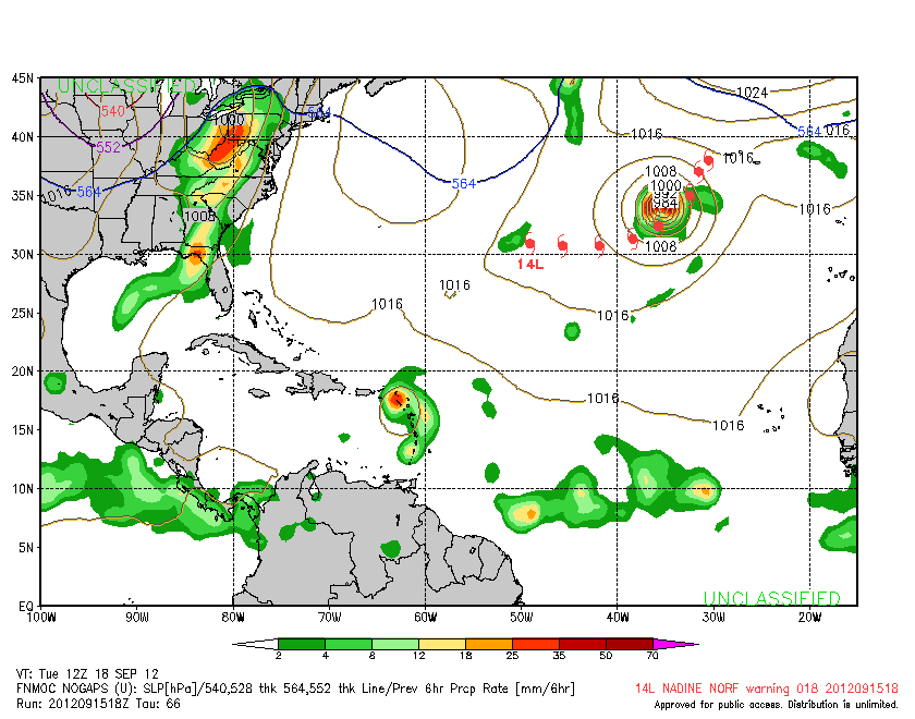
12z run.
0 likes
Visit the Caribbean-Central America Weather Thread where you can find at first post web cams,radars
and observations from Caribbean basin members Click Here
and observations from Caribbean basin members Click Here
-
Kingarabian

- S2K Supporter

- Posts: 15435
- Joined: Sat Aug 08, 2009 3:06 am
- Location: Honolulu, Hawaii
-
Hurricaneman

- Category 5

- Posts: 7282
- Age: 43
- Joined: Tue Aug 31, 2004 3:24 pm
- Location: central florida
Re: ATL: INVEST 92L - Models
The models are reallt anemic for this one, I do believe the models are underestimating this, but I also do think that this will be weaker than the SHIPS and LBAR have in their output
The posts in this forum are NOT official forecast and should not be used as such. They are just the opinion of the poster and may or may not be backed by sound meteorological data. They are NOT endorsed by any professional institution or storm2k.org. For official information, please refer to the NHC and NWS products.
The posts in this forum are NOT official forecast and should not be used as such. They are just the opinion of the poster and may or may not be backed by sound meteorological data. They are NOT endorsed by any professional institution or storm2k.org. For official information, please refer to the NHC and NWS products.
0 likes
-
cycloneye
- Admin
- Posts: 139088
- Age: 67
- Joined: Thu Oct 10, 2002 10:54 am
- Location: San Juan, Puerto Rico
Re: ATL: INVEST 92L - Models
00z Models

Code: Select all
CHGHUR
TROPICAL CYCLONE GUIDANCE MESSAGE
NWS NATIONAL HURRICANE CENTER MIAMI FL
0010 UTC SUN SEP 16 2012

DISCLAIMER...NUMERICAL MODELS ARE SUBJECT TO LARGE ERRORS.
PLEASE REFER TO NHC OFFICIAL FORECASTS FOR TROPICAL CYCLONE
AND SUBTROPICAL CYCLONE INFORMATION.

ATLANTIC OBJECTIVE AIDS FOR

DISTURBANCE INVEST (AL922012) 20120916 0000 UTC

        ...00 HRS...   ...12 HRS...   ...24 HRS. ..   ...36 HRS...
        120916  0000   120916  1200   120917  0000   120917  1200

         LAT    LON     LAT    LON     LAT    LON     LAT    LON
BAMS    13.3N  54.3W   13.9N  56.0W   14.5N  57.4W   14.9N  59.1W
BAMD    13.3N  54.3W   14.0N  57.3W   14.8N  60.0W   15.4N  62.4W
BAMM    13.3N  54.3W   14.0N  56.6W   14.7N  58.7W   15.3N  60.9W
LBAR    13.3N  54.3W   14.2N  56.8W   15.2N  59.1W   16.1N  61.1W
SHIP        25KTS          29KTS          36KTS          45KTS
DSHP        25KTS          29KTS          36KTS          45KTS

        ...48 HRS...   ...72 HRS...   ...96 HRS. ..   ..120 HRS...
        120918  0000   120919  0000   120920  0000   120921  0000

         LAT    LON     LAT    LON     LAT    LON     LAT    LON
BAMS    15.5N  60.9W   16.4N  65.5W   17.6N  70.4W   18.7N  75.2W
BAMD    15.9N  64.7W   16.9N  69.5W   18.4N  73.9W   19.9N  76.9W
BAMM    15.8N  63.1W   16.7N  67.9W   18.0N  73.0W   19.4N  77.1W
LBAR    17.1N  62.9W   18.6N  66.6W   20.2N  70.5W   21.6N  73.3W
SHIP        57KTS          77KTS          89KTS          97KTS
DSHP        57KTS          77KTS          89KTS          92KTS

         ...INITIAL CONDITIONS...
LATCUR =  13.3N LONCUR =  54.3W DIRCUR = 285DEG SPDCUR =  12KT
LATM12 =  12.7N LONM12 =  51.8W DIRM12 = 282DEG SPDM12 =  12KT
LATM24 =  12.3N LONM24 =  49.5W
WNDCUR =   25KT RMAXWD =   80NM WNDM12 =   25KT
CENPRS = 1010MB OUTPRS = 1012MB OUTRAD =   90NM SDEPTH =   S
RD34NE =    0NM RD34SE =    0NM RD34SW =    0NM RD34NW =   0NM
0 likes
Visit the Caribbean-Central America Weather Thread where you can find at first post web cams,radars
and observations from Caribbean basin members Click Here
and observations from Caribbean basin members Click Here

Re: ATL: INVEST 92L - Models

Apparently some GFS ensembles want to develop it, but the operational run drops it after a day or so.
0 likes
-
cycloneye
- Admin
- Posts: 139088
- Age: 67
- Joined: Thu Oct 10, 2002 10:54 am
- Location: San Juan, Puerto Rico
Re: ATL: INVEST 92L - Models
GFS Ensembles. Will the operational GFS come aboard?

0 likes
Visit the Caribbean-Central America Weather Thread where you can find at first post web cams,radars
and observations from Caribbean basin members Click Here
and observations from Caribbean basin members Click Here

ATL: INVEST 92L - Discussion
Take a look at intensity guidance if it gets into the W. Carribean.

0 likes
The following post is NOT an official forecast and should not be used as such. It is just the opinion of the poster and may or may not be backed by sound meteorological data. It is NOT endorsed by any professional institution including storm2k.org For Official Information please refer to the NHC and NWS products.

Re: ATL: INVEST 92L - Discussion
blp wrote:Take a look at intensity guidance if it gets into the W. Carribean.
yep the SHIPS likes it a whole lot.....
0 likes
-
Hurricane Alexis
- Category 2
- Posts: 683
- Age: 27
- Joined: Thu Jun 14, 2012 7:59 pm
- Location: Miami,Florida
Re: ATL: INVEST 92L - Discussion
blp wrote:Take a look at intensity guidance if it gets into the W. Carribean.
A cyclone that deep will likely turn towards the north earlier with all that troughing in the SE US.
0 likes
Personal Forecast Disclaimer:
The posts in this forum are NOT official forecast and should not be used as such. They are just the opinion of the poster and may or may not be backed by sound meteorological data. They are NOT endorsed by any professional institution or storm2k.org. For official information, please refer to the NHC and NWS products.
The posts in this forum are NOT official forecast and should not be used as such. They are just the opinion of the poster and may or may not be backed by sound meteorological data. They are NOT endorsed by any professional institution or storm2k.org. For official information, please refer to the NHC and NWS products.
-
Hurricane Alexis
- Category 2
- Posts: 683
- Age: 27
- Joined: Thu Jun 14, 2012 7:59 pm
- Location: Miami,Florida
Re: ATL: INVEST 92L - Models
0 likes
Personal Forecast Disclaimer:
The posts in this forum are NOT official forecast and should not be used as such. They are just the opinion of the poster and may or may not be backed by sound meteorological data. They are NOT endorsed by any professional institution or storm2k.org. For official information, please refer to the NHC and NWS products.
The posts in this forum are NOT official forecast and should not be used as such. They are just the opinion of the poster and may or may not be backed by sound meteorological data. They are NOT endorsed by any professional institution or storm2k.org. For official information, please refer to the NHC and NWS products.
-
cycloneye
- Admin
- Posts: 139088
- Age: 67
- Joined: Thu Oct 10, 2002 10:54 am
- Location: San Juan, Puerto Rico
Re: ATL: INVEST 92L - Models
12z Models

Code: Select all
WHXX01 KWBC 161302
CHGHUR
TROPICAL CYCLONE GUIDANCE MESSAGE
NWS NATIONAL HURRICANE CENTER MIAMI FL
1302 UTC SUN SEP 16 2012

DISCLAIMER...NUMERICAL MODELS ARE SUBJECT TO LARGE ERRORS.
PLEASE REFER TO NHC OFFICIAL FORECASTS FOR TROPICAL CYCLONE
AND SUBTROPICAL CYCLONE INFORMATION.

ATLANTIC OBJECTIVE AIDS FOR

DISTURBANCE INVEST (AL922012) 20120916 1200 UTC

        ...00 HRS...   ...12 HRS...   ...24 HRS. ..   ...36 HRS...
        120916  1200   120917  0000   120917  1200   120918  0000

         LAT    LON     LAT    LON     LAT    LON     LAT    LON
BAMS    13.3N  54.9W   14.0N  56.5W   14.5N  58.2W   15.0N  60.1W
BAMD    13.3N  54.9W   13.8N  57.6W   14.1N  60.3W   14.4N  62.9W
BAMM    13.3N  54.9W   13.9N  57.0W   14.4N  59.2W   14.8N  61.3W
LBAR    13.3N  54.9W   13.9N  57.2W   14.6N  59.6W   15.2N  61.8W
SHIP        25KTS          27KTS          32KTS          41KTS
DSHP        25KTS          27KTS          32KTS          41KTS

        ...48 HRS...   ...72 HRS...   ...96 HRS. ..   ..120 HRS...
        120918  1200   120919  1200   120920  1200   120921  1200

         LAT    LON     LAT    LON     LAT    LON     LAT    LON
BAMS    15.4N  62.1W   16.5N  66.5W   17.5N  71.1W   18.1N  75.6W
BAMD    14.6N  65.5W   15.3N  70.6W   16.2N  75.0W   16.9N  78.9W
BAMM    15.1N  63.8W   15.7N  68.9W   16.6N  74.2W   17.5N  79.1W
LBAR    15.8N  64.2W   16.7N  69.0W   18.5N  73.6W   20.8N  78.3W
SHIP        51KTS          68KTS          80KTS          87KTS
DSHP        51KTS          68KTS          80KTS          87KTS

         ...INITIAL CONDITIONS...
LATCUR =  13.3N LONCUR =  54.9W DIRCUR = 275DEG SPDCUR =  11KT
LATM12 =  13.1N LONM12 =  52.7W DIRM12 = 276DEG SPDM12 =  11KT
LATM24 =  12.9N LONM24 =  50.5W
WNDCUR =   25KT RMAXWD =   80NM WNDM12 =   25KT
CENPRS = 1011MB OUTPRS = 1014MB OUTRAD =  200NM SDEPTH =   S
RD34NE =    0NM RD34SE =    0NM RD34SW =    0NM RD34NW =   0NM
0 likes
Visit the Caribbean-Central America Weather Thread where you can find at first post web cams,radars
and observations from Caribbean basin members Click Here
and observations from Caribbean basin members Click Here
-
floridasun78
- Category 5
- Posts: 3755
- Joined: Sun May 17, 2009 10:16 pm
- Location: miami fl

Re: ATL: INVEST 92L - Models
floridasun78 wrote:so models dont want now make turn toward south fl ?
Well looking at the end of that run, it would appear as if 92L is slowing down some (which would make sense given the anticipated long wave & trough position). As quick ascent northward in the mid term would appear to shear the system apart. Looks like a set up that could add some precipitation to W. Cuba and South Florida while a sheared mess slides NNE along the decayed front.
0 likes
Personal Forecast Disclaimer:
The posts in this forum are NOT official forecast and should not be used as such. They are just the opinion of the poster and may or may not be backed by sound meteorological data. They are NOT endorsed by any professional institution or storm2k.org. For official information, please refer to the NHC and NWS products.
The posts in this forum are NOT official forecast and should not be used as such. They are just the opinion of the poster and may or may not be backed by sound meteorological data. They are NOT endorsed by any professional institution or storm2k.org. For official information, please refer to the NHC and NWS products.
-
CrazyC83
- Professional-Met

- Posts: 33393
- Joined: Tue Mar 07, 2006 11:57 pm
- Location: Deep South, for the first time!
SHIPS seems to be on crack there IMO. The odds of this developing is low, forget turning into dangerous Hurricane Oscar (the Grouch).
Personal Forecast Disclaimer:
The posts in this forum are NOT official forecast and should not be used as such. They are just the opinion of the poster and may or may not be backed by sound meteorological data. They are NOT endorsed by any professional institution or storm2k.org. For official information, please refer to the NHC and NWS products.
0 likes
Who is online
Users browsing this forum: No registered users and 135 guests