016
WHXX01 KWBC 081303
CHGHUR
TROPICAL CYCLONE GUIDANCE MESSAGE
NWS NATIONAL HURRICANE CENTER MIAMI FL
1303 UTC MON OCT 8 2012
DISCLAIMER...NUMERICAL MODELS ARE SUBJECT TO LARGE ERRORS.
PLEASE REFER TO NHC OFFICIAL FORECASTS FOR TROPICAL CYCLONE
AND SUBTROPICAL CYCLONE INFORMATION.
ATLANTIC OBJECTIVE AIDS FOR
DISTURBANCE INVEST (AL982012) 20121008 1200 UTC
...00 HRS... ...12 HRS... ...24 HRS. .. ...36 HRS...
121008 1200 121009 0000 121009 1200 121010 0000
LAT LON LAT LON LAT LON LAT LON
BAMS 8.2N 37.6W 8.8N 41.2W 9.6N 44.6W 10.5N 47.9W
BAMD 8.2N 37.6W 8.1N 39.7W 8.4N 41.6W 9.1N 43.4W
BAMM 8.2N 37.6W 8.3N 40.3W 8.7N 42.8W 9.4N 45.3W
LBAR 8.2N 37.6W 8.3N 40.3W 8.5N 43.0W 8.8N 45.4W
SHIP 25KTS 26KTS 27KTS 29KTS
DSHP 25KTS 26KTS 27KTS 29KTS
...48 HRS... ...72 HRS... ...96 HRS. .. ..120 HRS...
121010 1200 121011 1200 121012 1200 121013 1200
LAT LON LAT LON LAT LON LAT LON
BAMS 11.4N 51.3W 12.7N 58.1W 13.0N 64.8W 12.7N 70.3W
BAMD 10.0N 45.0W 12.4N 47.3W 15.4N 48.1W 18.7N 47.7W
BAMM 10.3N 47.6W 12.7N 52.0W 14.9N 55.4W 16.8N 58.4W
LBAR 9.4N 47.6W 11.1N 51.5W 14.0N 54.3W 16.8N 55.4W
SHIP 30KTS 27KTS 22KTS 22KTS
DSHP 30KTS 27KTS 22KTS 22KTS
...INITIAL CONDITIONS...
LATCUR = 8.2N LONCUR = 37.6W DIRCUR = 275DEG SPDCUR = 17KT
LATM12 = 8.0N LONM12 = 34.2W DIRM12 = 272DEG SPDM12 = 17KT
LATM24 = 8.0N LONM24 = 30.8W
WNDCUR = 25KT RMAXWD = 60NM WNDM12 = 20KT
CENPRS = 1008MB OUTPRS = 1012MB OUTRAD = 200NM SDEPTH = M
RD34NE = 0NM RD34SE = 0NM RD34SW = 0NM RD34NW = 0NM
$$
NNNN
ATL: RAFAEL - Models
Moderator: S2k Moderators
-
Florida1118
- Category 5

- Posts: 1805
- Age: 27
- Joined: Sat Jun 19, 2010 12:57 pm
- Location: Tampa, Florida
ATL: RAFAEL - Models
0 likes
-
cycloneye

- Admin

- Posts: 139173
- Age: 67
- Joined: Thu Oct 10, 2002 10:54 am
- Location: San Juan, Puerto Rico
Re: ATL: INVEST 98L - Models
If 12z GFS pans out,the NE Caribbean islands would be unde the gun. But is still early in the game.

0 likes
Visit the Caribbean-Central America Weather Thread where you can find at first post web cams,radars
and observations from Caribbean basin members Click Here
and observations from Caribbean basin members Click Here
-
HurricaneFan
- Tropical Storm

- Posts: 192
- Age: 40
- Joined: Tue Jan 18, 2011 6:16 pm
- Location: Anguilla,Leeward Islands 18.3N 63.0W
Re: ATL: INVEST 98L - Models
The new GFS have it only there on Monday?If so,what slows it down so much?
I mean Jeff Masters was saying it can reach the Islands on Friday(possibly even Thursday).So that is quite a difference.
I mean Jeff Masters was saying it can reach the Islands on Friday(possibly even Thursday).So that is quite a difference.
0 likes

Re: ATL: INVEST 98L - Models
cycloneye wrote:If what GFS pans out,the NE Caribbean islands would be unde the gun. But is still early in the game.
Hey cycloneeye, just to add to the long range "eye-balling, I had noticed over the last couple days that the GFS 500mb seemed to show significant heights around the 144 hour mark. Looking at the 12Z 500mb just now, I can see where a window would exist, though slightly ominous given ridging north of the system when near P.R. as well as appearant ridging over the Gulf at that time. Of greater interest however was looking at the EURO from last night. Odd as it would be, it would seem plausible depending on timing for a "smallish" type system to possibly try to continue to squirt West/WNW towards Fla. Certainly would seem odd to even think about a late Oct. system potentially approaching the Bahamas from the East (rather than from a more Southerly direction). Then again, timing like always - is everything. Last thing to keep in mind is that historically, October systems that are east of the islands seem to "crawl" westward. Finally, havn't even begun to consider the likely upper level conditions so the entire topic might be mute. Will be interesting to see if the EURO (and other models, outside of CMC) start to come on board over the next few runs
0 likes
Personal Forecast Disclaimer:
The posts in this forum are NOT official forecast and should not be used as such. They are just the opinion of the poster and may or may not be backed by sound meteorological data. They are NOT endorsed by any professional institution or storm2k.org. For official information, please refer to the NHC and NWS products.
The posts in this forum are NOT official forecast and should not be used as such. They are just the opinion of the poster and may or may not be backed by sound meteorological data. They are NOT endorsed by any professional institution or storm2k.org. For official information, please refer to the NHC and NWS products.
Re: ATL: INVEST 98L - Models
HurricaneFan wrote:The new GFS have it only there on Monday?If so,what slows it down so much?
I mean Jeff Masters was saying it can reach the Islands on Friday(possibly even Thursday).So that is quite a difference.
I'd go with the GFS, though not to slight Jeff Masters who I have a high regard for. Once you get into October, I've found over the years that most easterly waves suddently lose the same degree of mid level steering. Rather than coming off Africa with a surge, often times watching waves attempt to traverse the tropical Atlantic becomes like watching glue dry. Seasons are all different of course, and am guessing that after 98L, we won't see any further lower latitude tropical Atlantic development with exception to that which basic climotology might suggest (Central/Western Caribbean).
0 likes
Personal Forecast Disclaimer:
The posts in this forum are NOT official forecast and should not be used as such. They are just the opinion of the poster and may or may not be backed by sound meteorological data. They are NOT endorsed by any professional institution or storm2k.org. For official information, please refer to the NHC and NWS products.
The posts in this forum are NOT official forecast and should not be used as such. They are just the opinion of the poster and may or may not be backed by sound meteorological data. They are NOT endorsed by any professional institution or storm2k.org. For official information, please refer to the NHC and NWS products.
-
cycloneye
- Admin
- Posts: 139173
- Age: 67
- Joined: Thu Oct 10, 2002 10:54 am
- Location: San Juan, Puerto Rico
Re: ATL: INVEST 98L - Models
12z CMC animation.Look what happens at the end of run with the movement.
http://moe.met.fsu.edu/cgi-bin/cmctc2.c ... =Animation
http://moe.met.fsu.edu/cgi-bin/cmctc2.c ... =Animation
0 likes
Visit the Caribbean-Central America Weather Thread where you can find at first post web cams,radars
and observations from Caribbean basin members Click Here
and observations from Caribbean basin members Click Here
-
Fego

- S2K Supporter

- Posts: 767
- Age: 64
- Joined: Sun Apr 18, 2004 7:58 pm
- Location: San Juan, Puerto Rico
- Contact:
Re: ATL: INVEST 98L - Models
ECM at 12Z, more close to PR than the GFS and CMC runs.


0 likes
Go Giants! Go Niners! Go Warriors!
-
cycloneye
- Admin
- Posts: 139173
- Age: 67
- Joined: Thu Oct 10, 2002 10:54 am
- Location: San Juan, Puerto Rico
Re: ATL: INVEST 98L - Models
Here is one of the GFS ensemble members going much more bullish in intensity than the operational.

0 likes
Visit the Caribbean-Central America Weather Thread where you can find at first post web cams,radars
and observations from Caribbean basin members Click Here
and observations from Caribbean basin members Click Here
-
Hurricaneman

- Category 5
- Posts: 7282
- Age: 43
- Joined: Tue Aug 31, 2004 3:24 pm
- Location: central florida
Re: ATL: INVEST 98L - Models
The 18zGFS seems to split the energy and send the main part through the N antilles and out to sea while a smaller peice goes towards the west making landfall in central america, I don't know what to make of that maybe possible convective feedback
0 likes
-
vbhoutex

- Storm2k Executive
- Posts: 28975
- Age: 72
- Joined: Wed Oct 09, 2002 11:31 pm
- Location: Spring Branch area, Houston, TX
- Contact:
Re: ATL: INVEST 98L - Models
cycloneye wrote:12z CMC animation.Look what happens at the end of run with the movement.
http://moe.met.fsu.edu/cgi-bin/cmctc2.c ... =Animation
That is an interesting run!!! Not good for the islands, and maybe not good for the US, with the response to the high closing off, even though I would suspect it would get picked up and taken back out to sea prior to reaching the mainland. And no I have not looked past this run.
0 likes
Skywarn, C.E.R.T.
Please click below to donate to STORM2K to help with the expenses of keeping the site going:

Please click below to donate to STORM2K to help with the expenses of keeping the site going:
-
floridasun78
- Category 5
- Posts: 3755
- Joined: Sun May 17, 2009 10:16 pm
- Location: miami fl
Re: ATL: INVEST 98L - Models
i hear that high may be strong as summer high pull any system toward west their no front forecast for east coast next week what i see
0 likes
-
cycloneye
- Admin
- Posts: 139173
- Age: 67
- Joined: Thu Oct 10, 2002 10:54 am
- Location: San Juan, Puerto Rico
Re: ATL: INVEST 98L - Models
The 00z EURO is more agressive in intensity than past runs.

0 likes
Visit the Caribbean-Central America Weather Thread where you can find at first post web cams,radars
and observations from Caribbean basin members Click Here
and observations from Caribbean basin members Click Here
-
wxman57

- Moderator-Pro Met

- Posts: 22482
- Age: 66
- Joined: Sat Jun 21, 2003 8:06 pm
- Location: Houston, TX (southwest)
Re: ATL: INVEST 98L - Models
It sure doesn't have the look of something that's going to be developing anytime soon.
0 likes
-
CrazyC83
- Professional-Met

- Posts: 33393
- Joined: Tue Mar 07, 2006 11:57 pm
- Location: Deep South, for the first time!
Re: ATL: INVEST 98L - Models
vbhoutex wrote:cycloneye wrote:12z CMC animation.Look what happens at the end of run with the movement.
http://moe.met.fsu.edu/cgi-bin/cmctc2.c ... =Animation
That is an interesting run!!! Not good for the islands, and maybe not good for the US, with the response to the high closing off, even though I would suspect it would get picked up and taken back out to sea prior to reaching the mainland. And no I have not looked past this run.
Wouldn't that suggest a stalling out of the storm? It seems unlikely in mid-October it would continue west at that latitude...
0 likes

Re: ATL: INVEST 98L - Models
floridasun78 wrote:i hear that high may be strong as summer high pull any system toward west their no front forecast for east coast next week what i see
Source of what you are "hearing"?
0 likes
-
gatorcane

- S2K Supporter
- Posts: 23499
- Age: 46
- Joined: Sun Mar 13, 2005 3:54 pm
- Location: Boca Raton, FL
The 12Z GFS is quite intriguing. Looks like it sends the area towards the NE Leewards and then moves a weak low west towards the Bahamas/Cuba while developing a deeper low more east that moves NNW. Decoupling perhaps? This is the long-range (252 hours from now) so not sure how much I believe it.

0 likes
-
cycloneye
- Admin
- Posts: 139173
- Age: 67
- Joined: Thu Oct 10, 2002 10:54 am
- Location: San Juan, Puerto Rico
Re: ATL: INVEST 98L - Models
What a 24 hour change by CMC at 12z,different from yesterday's run.
http://moe.met.fsu.edu/cgi-bin/cmctc2.c ... =Animation
http://moe.met.fsu.edu/cgi-bin/cmctc2.c ... =Animation
0 likes
Visit the Caribbean-Central America Weather Thread where you can find at first post web cams,radars
and observations from Caribbean basin members Click Here
and observations from Caribbean basin members Click Here
-
tolakram
- Admin
- Posts: 19165
- Age: 60
- Joined: Sun Aug 27, 2006 8:23 pm
- Location: Florence, KY (name is Mark)
Re: ATL: INVEST 98L - Models
Personal Forecast Disclaimer:
The posts in this forum are NOT official forecast and should not be used as such. They are just the opinion of the poster and may or may not be backed by sound meteorological data. They are NOT endorsed by any professional institution or storm2k.org. For official information, please refer to the NHC and NWS products.
The shear over the Gulf and even Florida looks too destructive to let anything organized through.
Shear forecasts are horrible, so look at this with an entire salt shaker.
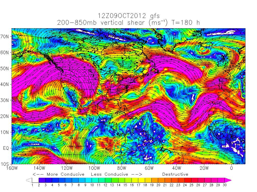
The slow movement over the islands is the big concern IMO, and this is the time of year for this kind of trouble.
The posts in this forum are NOT official forecast and should not be used as such. They are just the opinion of the poster and may or may not be backed by sound meteorological data. They are NOT endorsed by any professional institution or storm2k.org. For official information, please refer to the NHC and NWS products.
The shear over the Gulf and even Florida looks too destructive to let anything organized through.
Shear forecasts are horrible, so look at this with an entire salt shaker.
The slow movement over the islands is the big concern IMO, and this is the time of year for this kind of trouble.
0 likes
M a r k
- - - - -
Join us in chat: Storm2K Chatroom Invite. Android and IOS apps also available.
The posts in this forum are NOT official forecasts and should not be used as such. Posts are NOT endorsed by any professional institution or STORM2K.org. For official information and forecasts, please refer to NHC and NWS products.


Who is online
Users browsing this forum: No registered users and 73 guests