What about it? The 5 day graph only shows areas that are a threat to develop into TCs in the next 5 days. TD Two has already developed. Helps keep the map from getting too busy.
ATL: TWO - Remnants - Discussion
Moderator: S2k Moderators
Re: ATL: TWO - Tropical Depression - Discussion
What about it? The 5 day graph only shows areas that are a threat to develop into TCs in the next 5 days. TD Two has already developed. Helps keep the map from getting too busy.
0 likes
-
cycloneye

- Admin

- Posts: 149467
- Age: 69
- Joined: Thu Oct 10, 2002 10:54 am
- Location: San Juan, Puerto Rico
Re: ATL: TWO - Tropical Depression - Discussion
00z Best Track remains as TD.
AL, 02, 2014072200, , BEST, 0, 120N, 444W, 30, 1012, TD
AL, 02, 2014072200, , BEST, 0, 120N, 444W, 30, 1012, TD
0 likes
Visit the Caribbean-Central America Weather Thread where you can find at first post web cams,radars
and observations from Caribbean basin members Click Here
and observations from Caribbean basin members Click Here


-
Hurricane Andrew

- S2K Supporter

- Posts: 1891
- Age: 27
- Joined: Sun May 23, 2010 2:53 pm
- Location: KS
Re:
Nimbus wrote:Kind of dry out there nut TD2 is staying small and is managing to keep moist convective lift in the low sheer environment. Unless the sheer forecast changes it might be naked swirl time in the Caribbean.
WXman57 probably called this one already JIM.
Shear is quite low for another few hundred miles...SAL on the other hand...not so much.
I say this makes a brief weak-mod TS before weakening back to a TD. Wether or not it makes it past 96 Hours, we shall see.
FORECAST IS NOT PROFESSIONAL, AND SHOULD NOT BE USED AS SUCH.
0 likes
The Enthusiast
NREMT-AEMT, WX nerd
Irene '11, Sandy '12, Irma '17 (SAR)
"Hard to think we were born to live this way..." -Wage War
-
GrimReaper

- Category 1

- Posts: 409
- Joined: Fri May 23, 2003 10:17 pm
Re: Re:
RL3AO wrote:GrimReaper wrote:How did this go from a 10% situation to a 70% in just a few hours? And...why are they saying conditions are unfavorable, yet keeping the 70% through the 5-day?
The five day can't be lower than the two day. Can't say 70% chance of forming within two days and a 40% chance within five days. The fact that they are the same tells you that conditions get unfavorable and its best chance is in the near term.
Thank you for that answer..... I didn't know that!
0 likes
-
cycloneye
- Admin
- Posts: 149467
- Age: 69
- Joined: Thu Oct 10, 2002 10:54 am
- Location: San Juan, Puerto Rico
Re: ATL: TWO - Tropical Depression - Discussion
SUMMARY OF 1100 PM AST...0300 UTC...INFORMATION
-----------------------------------------------
LOCATION...12.0N 45.1W
ABOUT 1110 MI...1790 KM E OF THE LESSER ANTILLES
MAXIMUM SUSTAINED WINDS...35 MPH...55 KM/H
PRESENT MOVEMENT...W OR 280 DEGREES AT 16 MPH...26 KM/H
MINIMUM CENTRAL PRESSURE...1012 MB...29.89 INCHES
-----------------------------------------------
LOCATION...12.0N 45.1W
ABOUT 1110 MI...1790 KM E OF THE LESSER ANTILLES
MAXIMUM SUSTAINED WINDS...35 MPH...55 KM/H
PRESENT MOVEMENT...W OR 280 DEGREES AT 16 MPH...26 KM/H
MINIMUM CENTRAL PRESSURE...1012 MB...29.89 INCHES
0 likes
Visit the Caribbean-Central America Weather Thread where you can find at first post web cams,radars
and observations from Caribbean basin members Click Here
and observations from Caribbean basin members Click Here
-
HurricaneTracker2031
- Tropical Storm

- Posts: 248
- Age: 26
- Joined: Fri Jul 19, 2013 7:20 pm
- Location: Pembroke Pines, FL, USA
- Contact:
Re: ATL: TWO - Tropical Depression - Discussion
TD TWO will have to combat the dry air and SAL in order for it to survive. It also needs to gain more convection and grow in size, so it can support itself for the next 72 hours. I believe that it might sustain itself and will intensify after passing the Leeward Islands.
Synopsis for Tropical Depression Two and other areas in other basins: http://goo.gl/0f8wWA
Personal Forecast Disclaimer:
The posts in this forum are NOT official forecast and should not be used as such. They are just the opinion of the poster and may or may not be backed by sound meteorological data. They are NOT endorsed by any professional institution or storm2k.org. For official information, please refer to the NHC and NWS products.
0 likes
SHORT VERSION OF DISCLAIMER: THIS SITE LINK BELOW IS NOT AN OFFICIAL FORECASTING OFFICE AND SHOULD NOT BE USED TO MAKE ANY EMERGENCY DECISIONS....
http://www.macstropicalweather.weebly.com
http://www.macstropicalweather.weebly.com

Re: ATL: TWO - Tropical Depression - Discussion
The northern outflow and precipation pocket that has been protecting it is shrinking fast. Soon the dry air will start to work its way in from the North. If it was a larger system I can see it surviving longer but it is too small to take on a strong push of dry air.
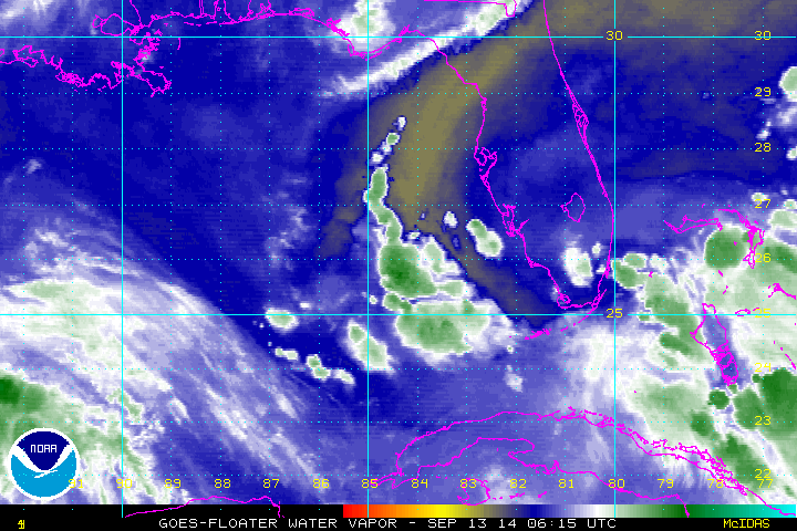
http://www.ssd.noaa.gov/PS/TROP/floaters/02L/imagery/wv_lalo-animated.gif
http://www.ssd.noaa.gov/PS/TROP/floaters/02L/imagery/wv_lalo-animated.gif
0 likes
The following post is NOT an official forecast and should not be used as such. It is just the opinion of the poster and may or may not be backed by sound meteorological data. It is NOT endorsed by any professional institution including storm2k.org For Official Information please refer to the NHC and NWS products.
Re: ATL: TWO - Tropical Depression - Discussion
This image is a great illustration of the challenge.

0 likes
The following post is NOT an official forecast and should not be used as such. It is just the opinion of the poster and may or may not be backed by sound meteorological data. It is NOT endorsed by any professional institution including storm2k.org For Official Information please refer to the NHC and NWS products.
-
CFLHurricane

- Category 1
- Posts: 349
- Joined: Thu Mar 27, 2014 5:56 pm
- Location: Floriduh
Re: ATL: TWO - Tropical Depression - Discussion
blp wrote:This image is a great illustration of the challenge.
Yeah I expect Two's demise, shortly.
http://www.cosgan.de/images/smilie/muede/d040.gif
0 likes
I'm not a meteorologist, but I did stay at a motel 8.
-
tropicwatch

- Category 5

- Posts: 3426
- Age: 62
- Joined: Sat Jun 02, 2007 10:01 am
- Location: The Villages, Florida
- Contact:
Re: ATL: TWO - Tropical Depression - Discussion
TD 2 is still doing pretty good at keeping dry air out.
0 likes
Tropicwatch
Agnes 72', Eloise 75, Elena 85', Kate 85', Charley 86', Florence 88', Beryl 94', Dean 95', Erin 95', Opal 95', Earl 98', Georges 98', Ivan 2004', Arlene 2005', Dennis 2005', Ida 2009' Debby 2012' Irma 2017' Michael 2018'
Agnes 72', Eloise 75, Elena 85', Kate 85', Charley 86', Florence 88', Beryl 94', Dean 95', Erin 95', Opal 95', Earl 98', Georges 98', Ivan 2004', Arlene 2005', Dennis 2005', Ida 2009' Debby 2012' Irma 2017' Michael 2018'
-
wxman57

- Moderator-Pro Met

- Posts: 23174
- Age: 68
- Joined: Sat Jun 21, 2003 8:06 pm
- Location: Houston, TX (southwest)
Re: ATL: TWO - Tropical Depression - Discussion
I think it peaked yesterday, possibly at 35 kts. Definitely less organized today. Virtually no banding features now. LLC is questionable. Bye, Two...
0 likes
-
tolakram
- Admin
- Posts: 20185
- Age: 62
- Joined: Sun Aug 27, 2006 8:23 pm
- Location: Florence, KY (name is Mark)
Re: ATL: TWO - Tropical Depression - Discussion
0 likes
M a r k
- - - - -
Join us in chat: Storm2K Chatroom Invite. Android and IOS apps also available.
The posts in this forum are NOT official forecasts and should not be used as such. Posts are NOT endorsed by any professional institution or STORM2K.org. For official information and forecasts, please refer to NHC and NWS products.
-
northjaxpro

- S2K Supporter
- Posts: 8900
- Joined: Mon Sep 27, 2010 11:21 am
- Location: Jacksonville, FL
Re: ATL: TWO - Tropical Depression - Discussion
wxman57 wrote:I think it peaked yesterday, possibly at 35 kts. Definitely less organized today. Virtually no banding features now. LLC is questionable. Bye, Two...
Yeah, I agree. I am having a tough time discerning the LLC on satellite imagery this morning. Also, no organized convection if there is still a LLC. Appears convection is pushing farther westward ahead of where the LLC was positioned on the last advisory. The anticipated downward trend has begun IMO and Bones will be called in real soon to give his final proclamation.
0 likes
NEVER, EVER SAY NEVER in the tropics and weather in general, and most importantly, with life itself!!
________________________________________________________________________________________
Fay 2008 Beryl 2012 Debby 2012 Colin 2016 Hermine 2016 Julia 2016 Matthew 2016 Irma 2017 Dorian 2019
________________________________________________________________________________________
Fay 2008 Beryl 2012 Debby 2012 Colin 2016 Hermine 2016 Julia 2016 Matthew 2016 Irma 2017 Dorian 2019
-
ConvergenceZone
.gif)
- Category 5
- Posts: 5241
- Joined: Fri Jul 29, 2005 1:40 am
- Location: Northern California
-
torrea40
Re: ATL: TWO - Tropical Depression - Discussion
TNumbers UP... 
DATE/TIME LAT LON CLASSIFICATION STORM
22/1145 UTC 12.4N 47.4W T1.5/1.5 02L -- Atlantic
DATE/TIME LAT LON CLASSIFICATION STORM
22/1145 UTC 12.4N 47.4W T1.5/1.5 02L -- Atlantic
0 likes

Who is online
Users browsing this forum: No registered users and 46 guests