CPAC: ISELLE - Post-Tropical
Moderator: S2k Moderators
-
Yellow Evan

- Professional-Met

- Posts: 16240
- Age: 27
- Joined: Fri Jul 15, 2011 12:48 pm
- Location: Henderson, Nevada/Honolulu, HI
- Contact:
-
Equilibrium
Thank goodness it did tame down from what it was a former monster but even the strength its at now its still a big blow.
09E ISELLE 140808 0000 19.0N 153.1W EPAC 70 991
The posts in this forum are NOT official forecast and should not be used as such. They are just the opinion of the poster and may or may not be backed by sound meteorological data. They are NOT endorsed by any professional institution or storm2k.org. For official information, please refer to the NHC and NWS products.
0 likes
-
tolakram
- Admin

- Posts: 20186
- Age: 62
- Joined: Sun Aug 27, 2006 8:23 pm
- Location: Florence, KY (name is Mark)
Re: CPAC: ISELLE - Hurricane
40 frame saved radar loop

0 likes
M a r k
- - - - -
Join us in chat: Storm2K Chatroom Invite. Android and IOS apps also available.
The posts in this forum are NOT official forecasts and should not be used as such. Posts are NOT endorsed by any professional institution or STORM2K.org. For official information and forecasts, please refer to NHC and NWS products.
-
Kingarabian

- S2K Supporter

- Posts: 16366
- Joined: Sat Aug 08, 2009 3:06 am
- Location: Honolulu, Hawaii
-
Yellow Evan
- Professional-Met
- Posts: 16240
- Age: 27
- Joined: Fri Jul 15, 2011 12:48 pm
- Location: Henderson, Nevada/Honolulu, HI
- Contact:
Re:
AFWeather wrote:If it fails to gain any more latitude from this point on, Oahu will end up getting nothing. Center needs to get to at least 19.5 and probably 20 unless it expands.
At this rate, it'll be lucky to get higher than 19.2N. Seems to be moving west.
0 likes

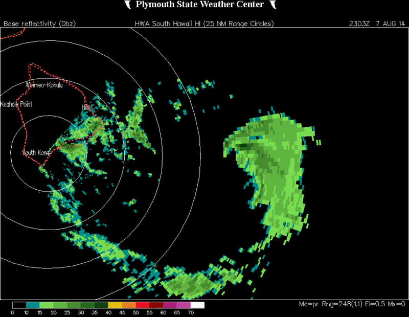
Re: CPAC: ISELLE - Hurricane
Another look at radar, I agree, it looks to be heading almost due west.
0 likes
-
AdamFirst

- S2K Supporter
- Posts: 2490
- Age: 36
- Joined: Thu Aug 14, 2008 10:54 am
- Location: Port Saint Lucie, FL
Re: CPAC: ISELLE - Hurricane
If it keeps its current trajectory I believe the core may come ashore near the Kalapana area, or over the Hawaii Volcanoes National Park. The trajectory would also bring the center of Iselle near or over Mauna Loa (13,600 feet), it'll be interesting to see how the peak would affect it.
The northern quadrant of the storm though is still strong - Hilo and towns to the south would still certainly be affected by potential hurricane conditions.
The northern quadrant of the storm though is still strong - Hilo and towns to the south would still certainly be affected by potential hurricane conditions.
Personal Forecast Disclaimer:
The posts in this forum are NOT official forecast and should not be used as such. They are just the opinion of the poster and may or may not be backed by sound meteorological data. They are NOT endorsed by any professional institution or storm2k.org. For official information, please refer to the NHC and NWS products.
0 likes
Dolphins Marlins Canes Golden Panthers HEAT
Andrew 1992 - Irene 1999 - Frances 2004 - Jeanne 2004 - Wilma 2005 - Fay 2008 - Isaac 2012 - Matthew 2016 - Irma 2017 - Dorian 2019 - Ian 2022 - Nicole 2022 - Milton 2024
Andrew 1992 - Irene 1999 - Frances 2004 - Jeanne 2004 - Wilma 2005 - Fay 2008 - Isaac 2012 - Matthew 2016 - Irma 2017 - Dorian 2019 - Ian 2022 - Nicole 2022 - Milton 2024
-
Kingarabian
- S2K Supporter
- Posts: 16366
- Joined: Sat Aug 08, 2009 3:06 am
- Location: Honolulu, Hawaii
-
Yellow Evan
- Professional-Met
- Posts: 16240
- Age: 27
- Joined: Fri Jul 15, 2011 12:48 pm
- Location: Henderson, Nevada/Honolulu, HI
- Contact:
Re:
Kingarabian wrote:We'll know in less than an hour what's going on. Last advisory foe the CPHC to shift the track south if needed
Rough estimate is that if it continues on its course it's been on via radar for the last 60-70 mins, it'll pass near or just south of South Point.
That's a somewhat big if though.
The posts in this forum are NOT official forecast and should not be used as such. They are just the opinion of the poster and may or may not be backed by sound meteorological data. They are NOT endorsed by any professional institution or storm2k.org. For official information, please refer to the NHC and NWS products.
0 likes
-
Kingarabian
- S2K Supporter
- Posts: 16366
- Joined: Sat Aug 08, 2009 3:06 am
- Location: Honolulu, Hawaii

-
AdamFirst
- S2K Supporter
- Posts: 2490
- Age: 36
- Joined: Thu Aug 14, 2008 10:54 am
- Location: Port Saint Lucie, FL
Kohala Radar (north shore of the big island) is in and out of service.
Core is also beginning to come into view on the short range radar.
000
NOUS60 PHFO 072153
FTMHKM
Message Date: Aug 07 2014 21:53:39
PHKM UPOLU POINT RADAR DATA WILL BE INTERMITTENT DUE TO HIGH WINDS FROM HURRICAN
E ISELLE BLOWING THE RADOME HATCH OPEN, WHICH PUTS THE RADAR INTO STANDBY AUTOMA
TICALLY. HFO
Core is also beginning to come into view on the short range radar.
0 likes
Dolphins Marlins Canes Golden Panthers HEAT
Andrew 1992 - Irene 1999 - Frances 2004 - Jeanne 2004 - Wilma 2005 - Fay 2008 - Isaac 2012 - Matthew 2016 - Irma 2017 - Dorian 2019 - Ian 2022 - Nicole 2022 - Milton 2024
Andrew 1992 - Irene 1999 - Frances 2004 - Jeanne 2004 - Wilma 2005 - Fay 2008 - Isaac 2012 - Matthew 2016 - Irma 2017 - Dorian 2019 - Ian 2022 - Nicole 2022 - Milton 2024
-
Chris_in_Tampa
- Category 5

- Posts: 5101
- Age: 42
- Joined: Thu Jun 21, 2007 11:06 pm
- Location: Tampa, Florida, USA
- Contact:

-
Yellow Evan
- Professional-Met
- Posts: 16240
- Age: 27
- Joined: Fri Jul 15, 2011 12:48 pm
- Location: Henderson, Nevada/Honolulu, HI
- Contact:
Re:
CrazyC83 wrote:We may see an EPAC/CPAC rarity: 2-hour advisories with position estimate updates...
That's never happened I don't think.
0 likes
-
supercane4867
- Category 5
- Posts: 4966
- Joined: Wed Nov 14, 2012 10:43 am

-
Kingarabian
- S2K Supporter
- Posts: 16366
- Joined: Sat Aug 08, 2009 3:06 am
- Location: Honolulu, Hawaii

Who is online
Users browsing this forum: No registered users and 17 guests