Is it my imagination, or has Arthur increased speed quite significantly? Viewing the visible floater, with the forecast points turned on, it appears (to my very untrained eye) that the center of the storm is nearing the 18:00Z forecast point, yet it's only 14:30Z as I write this.
Is Arthur 4 - 5 hours ahead of where he was forecast to be?
--------
I'm an AMATEUR. Refer to NHC for official info!
ATL: ARTHUR - Post-Tropical - Discussion
Moderator: S2k Moderators
Re: ATL: ARTHUR - Hurricane - Discussion
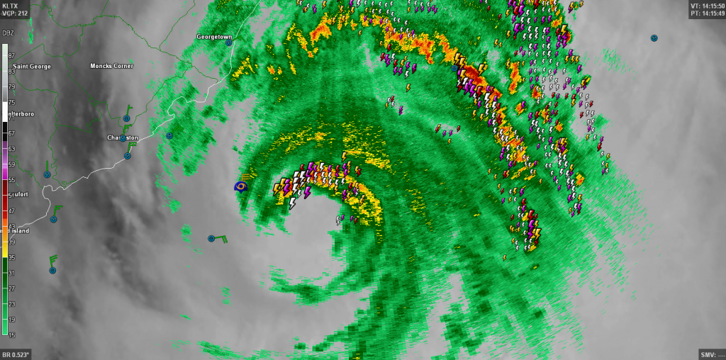
Good radar presentation as of 30 minutes ago, though on satellite the eye is no longer visible...
0 likes
-
ConvergenceZone
.gif)
- Category 5

- Posts: 5241
- Joined: Fri Jul 29, 2005 1:40 am
- Location: Northern California
Re: Re:
Alyono wrote:ConvergenceZone wrote:Now I know why the NHC isn't strengthening this above 85 mph, because of the following comment in their last discussion:
"the shear increases dramatically
as Arthur interacts with a deep-layer baroclinic zone moving off
of the East Coast of North America,"
Regardless, 85 mph is still a decient storm and people need to be on alert...........
it will be quite a bit more intense than 85 mph. May already be
Alyono, if that's the case, in your educated opinion(which I respect big time), why are they keeping it at 85mph when it's such a close potential threat the coast?
Usually the discussion will mention something like, "it could strengthen more significantly than we are showing?".... But they aren't saying any like that, which usually means they are pretty confident.
0 likes
-
TheAustinMan

- Category 5
- Posts: 1060
- Joined: Mon Jul 08, 2013 4:26 pm
- Location: Central TX / United States
Re:
KBBOCA wrote:Is it my imagination, or has Arthur increased speed quite significantly? Viewing the visible floater, with the forecast points turned on, it appears (to my very untrained eye) that the center of the storm is nearing the 18:00Z forecast point, yet it's only 14:30Z as I write this.
Is Arthur 4 - 5 hours ahead of where he was forecast to be?
--------
I'm an AMATEUR. Refer to NHC for official info!
Hmmm, very very interesting. I'm seeing the same thing too.

0 likes
Treat my opinions with a grain of salt. For official information see your local weather service.
“It's tough to make predictions, especially about the future.”
“It's tough to make predictions, especially about the future.”
Re: Re:
ConvergenceZone wrote:Alyono wrote:ConvergenceZone wrote:Now I know why the NHC isn't strengthening this above 85 mph, because of the following comment in their last discussion:
"the shear increases dramatically
as Arthur interacts with a deep-layer baroclinic zone moving off
of the East Coast of North America,"
Regardless, 85 mph is still a decient storm and people need to be on alert...........
it will be quite a bit more intense than 85 mph. May already be
Alyono, if that's the case, in your educated opinion(which I respect big time), why are they keeping it at 85mph when it's such a close potential threat the coast?
Usually the discussion will mention something like, "it could strengthen more significantly than we are showing?".... But they aren't saying any like that, which usually means they are pretty confident.
the 85 mph data is 3 hours old. They wont have recon until after the advisory.
As for their forecast, they are giving far too much weight to the LGE
0 likes
-
Bocadude85

- Category 5
- Posts: 2991
- Age: 39
- Joined: Mon Apr 18, 2005 2:20 pm
- Location: Honolulu,Hi
Re: ATL: ARTHUR - Hurricane - Discussion
Arthur is looking good this morning. I do not see anyway that he doesn't make landfall over the OBX. In my opinion the NHC should extend the hurricane warning to the NC/SC border. JMO
0 likes

Re: Re:
Alyono wrote:ConvergenceZone wrote:Alyono wrote:
it will be quite a bit more intense than 85 mph. May already be
Alyono, if that's the case, in your educated opinion(which I respect big time), why are they keeping it at 85mph when it's such a close potential threat the coast?
Usually the discussion will mention something like, "it could strengthen more significantly than we are showing?".... But they aren't saying any like that, which usually means they are pretty confident.
the 85 mph data is 3 hours old. They wont have recon until after the advisory.
As for their forecast, they are giving far too much weight to the LGE
I'm not even sure if the recon en route will be in time before the next update, must have been running late.
0 likes
-
SunnyThoughts
- Category 5
- Posts: 2263
- Joined: Wed Jul 09, 2003 12:42 pm
- Location: Pensacola, Florida
Re: ATL: ARTHUR - Hurricane - Discussion
 Look at all the ligtning...phew, doesn't lightning inside the eyewall/cdo indicate strengthening?
0 likes

-
TheAustinMan
- Category 5
- Posts: 1060
- Joined: Mon Jul 08, 2013 4:26 pm
- Location: Central TX / United States

-
TheEuropean

- Professional-Met

- Posts: 1797
- Age: 60
- Joined: Tue Sep 20, 2005 3:17 pm
- Location: Voerde, Germany
- Contact:
Re: ATL: ARTHUR - Hurricane - Discussion
11am public advisory:
Cat 2 in forcast now.
DATA FROM NOAA AND AIR FORCE RESERVE HURRICANE HUNTER AIRCRAFT
INDICATE THAT MAXIMUM SUSTAINED WINDS HAVE INCREASED TO NEAR 90
MPH...150 KM/H...WITH HIGHER GUSTS. SOME ADDITIONAL STRENGTHENING
IS FORECAST DURING THE NEXT 24 HOURS...AND ARTHUR IS EXPECTED TO
BE A CATEGORY TWO HURRICANE WHEN IT PASSES OVER OR NEAR THE NORTH
CAROLINA COAST. ARTHUR IS EXPECTED TO BEGIN WEAKENING FRIDAY NIGHT
AND IS FORECAST TO BECOME A POST-TROPICAL CYLONE SATURDAY.
Cat 2 in forcast now.
0 likes
-
ConvergenceZone
- Category 5
- Posts: 5241
- Joined: Fri Jul 29, 2005 1:40 am
- Location: Northern California
-
TheAustinMan
- Category 5
- Posts: 1060
- Joined: Mon Jul 08, 2013 4:26 pm
- Location: Central TX / United States

-
cycloneye

- Admin

- Posts: 149508
- Age: 69
- Joined: Thu Oct 10, 2002 10:54 am
- Location: San Juan, Puerto Rico
Re: ATL: ARTHUR - Hurricane - Discussion
Up to 90kts at peak.
FORECAST VALID 04/1200Z 36.3N 74.4W
MAX WIND 90 KT...GUSTS 110 KT.
FORECAST VALID 04/1200Z 36.3N 74.4W
MAX WIND 90 KT...GUSTS 110 KT.
0 likes
Visit the Caribbean-Central America Weather Thread where you can find at first post web cams,radars
and observations from Caribbean basin members Click Here
and observations from Caribbean basin members Click Here
-
Rail Dawg
- S2K Supporter

- Posts: 326
- Joined: Mon Aug 27, 2012 5:02 pm
- Location: Where the eye makes landfall.
That sudden tightening speaks volumes as we know.
I'm going with Cat 3 at the Cape Hatteras lighthouse.
The technology is good but I'm an old timer who used to plot this stuff by hand. Sometimes you just go with the gut.
Don't get me wrong... you guys are goooood!
I'm going with Cat 3 at the Cape Hatteras lighthouse.
The technology is good but I'm an old timer who used to plot this stuff by hand. Sometimes you just go with the gut.
Don't get me wrong... you guys are goooood!
0 likes
Although I have been a hurricane forecaster since 1980 that only means I've been wrong lots of times.
Re: ATL: ARTHUR - Hurricane - Discussion
Like I have been preaching for at least a month now that the subtropics conditions in the Atlantic are way better this year than last year.
0 likes

-
Bocadude85
- Category 5
- Posts: 2991
- Age: 39
- Joined: Mon Apr 18, 2005 2:20 pm
- Location: Honolulu,Hi
Re: ATL: ARTHUR - Hurricane - Discussion
NDG wrote:Like I have been preaching for at least a month now that the subtropics conditions in the Atlantic are way better this year than last year.
When is the last time we had a Cat 2 the first week of July? Its been awhile hasn't it?
0 likes
Who is online
Users browsing this forum: No registered users and 30 guests