Well this certainly spawned out of nowhere...
The vorticity needs to strengthen a bit: http://tropic.ssec.wisc.edu/real-time/a ... wg8vor.GIF
ATL: INVEST 92L - Discussion
Moderator: S2k Moderators
-
Evil Jeremy

- S2K Supporter

- Posts: 5463
- Age: 32
- Joined: Mon Apr 10, 2006 2:10 pm
- Location: Los Angeles, CA
-
tropicwatch

- Category 5

- Posts: 3426
- Age: 62
- Joined: Sat Jun 02, 2007 10:01 am
- Location: The Villages, Florida
- Contact:
0 likes
Tropicwatch
Agnes 72', Eloise 75, Elena 85', Kate 85', Charley 86', Florence 88', Beryl 94', Dean 95', Erin 95', Opal 95', Earl 98', Georges 98', Ivan 2004', Arlene 2005', Dennis 2005', Ida 2009' Debby 2012' Irma 2017' Michael 2018'
Agnes 72', Eloise 75, Elena 85', Kate 85', Charley 86', Florence 88', Beryl 94', Dean 95', Erin 95', Opal 95', Earl 98', Georges 98', Ivan 2004', Arlene 2005', Dennis 2005', Ida 2009' Debby 2012' Irma 2017' Michael 2018'
-
SFLcane

- S2K Supporter
- Posts: 10281
- Age: 48
- Joined: Sat Jun 05, 2010 1:44 pm
- Location: Lake Worth Florida
Re: ATL: INVEST 92L - Discussion
Small storm can spin up rather quickly with all that heat content near by and light winds its worth keeping tabs if you live in south florida.
0 likes
-
SFLcane
- S2K Supporter
- Posts: 10281
- Age: 48
- Joined: Sat Jun 05, 2010 1:44 pm
- Location: Lake Worth Florida
Re: ATL: INVEST 92L - Discussion
ATLANTIC OCEAN...
A LARGE UPPER LOW IS CENTERED NEAR 26N59W DRIFTING
SOUTHWESTWARD. SCATTERED MODERATE CONVECTION IS OCCURRING WITHIN
300NM OF THE LOW FROM 24N-31N BETWEEN 55W-64W. A SURFACE TROUGH
OVER THE CENTRAL BAHAMAS IS NEAR 24N77W TO 29N74W. THERE ARE
INDICATIONS IN VISIBLE SATELLITE IMAGERY THAT A CLOSED LOW MAY
BE DEVELOPING IN THE AREA.
0 likes
-
tolakram
- Admin

- Posts: 20186
- Age: 62
- Joined: Sun Aug 27, 2006 8:23 pm
- Location: Florence, KY (name is Mark)
Re: ATL: INVEST 92L - Discussion
longer live loop, speed up for best effect.
http://wwwghcc.msfc.nasa.gov/cgi-bin/get-goes?satellite=GOES-E%20CONUS&lat=27&lon=-76&info=vis&zoom=1&width=1000&height=800&quality=95&type=Animation&palette=ir1.pal&numframes=23
0 likes
M a r k
- - - - -
Join us in chat: Storm2K Chatroom Invite. Android and IOS apps also available.
The posts in this forum are NOT official forecasts and should not be used as such. Posts are NOT endorsed by any professional institution or STORM2K.org. For official information and forecasts, please refer to NHC and NWS products.

I'm surprised they didn't up the % at 2pm, are they waiting for a bit more persistence of the convection before doing so?
0 likes
The above post is not official and should not be used as such. It is the opinion of the poster and may or may not be backed by sound meteorological data. It is not endorsed by any professional institution or storm2k.org. For official information, please refer to the NHC and NWS products.

Re: ATL: INVEST 92L - Discussion
CSU updated their HTML5 floater:
http://rammb.cira.colostate.edu/ramsdis/online/loop.asp?data_folder=tropical/tropical_ge_4km_visir2_floater_1&width=640&height=480&number_of_images_to_display=12
http://rammb.cira.colostate.edu/ramsdis/online/loop.asp?data_folder=tropical/tropical_ge_4km_visir2_floater_1&width=640&height=480&number_of_images_to_display=12
0 likes
The following post is NOT an official forecast and should not be used as such. It is just the opinion of the poster and may or may not be backed by sound meteorological data. It is NOT endorsed by any professional institution including storm2k.org For Official Information please refer to the NHC and NWS products.
-
StormingB81

- S2K Supporter
- Posts: 5676
- Age: 44
- Joined: Thu Aug 27, 2009 1:45 am
- Location: Rockledge, Florida


Re:
StormingB81 wrote:After the week we had here of rain...looks like could be quiet a few more days of a lot of rain....Some of those models are interesting how it has it hitting then coming back over......a lot of wait and see
whats a good link to those models
0 likes
Once I see the REDS and GREENS Converge on a Base Velocity. ... I'm There!!
This is NOT an Official Forecast....Just my Opinion. For official information, please refer to the NHC and NWS products.
HIGHLIGHTS : '13 El Reno Tornado : 2013 Storm Chaser Tour, Joaquin; SC flood event, Matthew '16, Lowcountry Snow storm Jan '18
This is NOT an Official Forecast....Just my Opinion. For official information, please refer to the NHC and NWS products.
HIGHLIGHTS : '13 El Reno Tornado : 2013 Storm Chaser Tour, Joaquin; SC flood event, Matthew '16, Lowcountry Snow storm Jan '18
-
StormingB81
- S2K Supporter
- Posts: 5676
- Age: 44
- Joined: Thu Aug 27, 2009 1:45 am
- Location: Rockledge, Florida
I was just looking at the ones in the Models thread here: viewtopic.php?f=59&t=116735&hilit=
0 likes
Re: ATL: INVEST 92L - Discussion
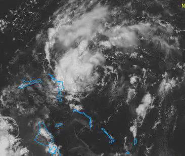
Great loop from today:
0 likes
The following post is NOT an official forecast and should not be used as such. It is just the opinion of the poster and may or may not be backed by sound meteorological data. It is NOT endorsed by any professional institution including storm2k.org For Official Information please refer to the NHC and NWS products.
Re: ATL: INVEST 92L - Discussion
West trackers in this area can spin up quickly and become problems, although I don't know if that applies to this system.
0 likes
-
tropicwatch
- Category 5
- Posts: 3426
- Age: 62
- Joined: Sat Jun 02, 2007 10:01 am
- Location: The Villages, Florida
- Contact:
Definite increase in vorticity this afternoon.

0 likes
Tropicwatch
Agnes 72', Eloise 75, Elena 85', Kate 85', Charley 86', Florence 88', Beryl 94', Dean 95', Erin 95', Opal 95', Earl 98', Georges 98', Ivan 2004', Arlene 2005', Dennis 2005', Ida 2009' Debby 2012' Irma 2017' Michael 2018'
Agnes 72', Eloise 75, Elena 85', Kate 85', Charley 86', Florence 88', Beryl 94', Dean 95', Erin 95', Opal 95', Earl 98', Georges 98', Ivan 2004', Arlene 2005', Dennis 2005', Ida 2009' Debby 2012' Irma 2017' Michael 2018'

-
Weatherboy1

- Category 5
- Posts: 1190
- Age: 50
- Joined: Mon Jul 05, 2004 1:50 pm
- Location: Jupiter/Sarasota, FL
-
Evil Jeremy
- S2K Supporter
- Posts: 5463
- Age: 32
- Joined: Mon Apr 10, 2006 2:10 pm
- Location: Los Angeles, CA

-
Weatherboy1
- Category 5
- Posts: 1190
- Age: 50
- Joined: Mon Jul 05, 2004 1:50 pm
- Location: Jupiter/Sarasota, FL
Re:
Evil Jeremy wrote:I have to imagine a Special TWO around 5ish if this persists. Convection bursting at the moment NW of the circulation.
I think a lot will depend on how quick the convection fires with this thing. There is now a clear low pressure area forming at the surface, in my opinion, but we don't have vigorous storms associated with it yet. That may not take long to happen though, given the relatively favorable environment. Definitely watching more closely today than yesterday considering it's not far off the FL coast!
0 likes
Who is online
Users browsing this forum: No registered users and 61 guests