ravyrn wrote:Alyono wrote:I'd like to know where the 90 mph winds are. Seeing nothing justifying anything above 85 mph
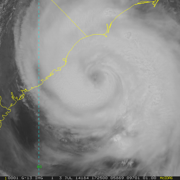
Yeah I'm not seeing it in the recon data. The highest I've seen is 71 knots in the SE quad.
84kt fl that 96 mph
Moderator: S2k Moderators

ravyrn wrote:Alyono wrote:I'd like to know where the 90 mph winds are. Seeing nothing justifying anything above 85 mph
Yeah I'm not seeing it in the recon data. The highest I've seen is 71 knots in the SE quad.
ravyrn wrote:Alyono wrote:I'd like to know where the 90 mph winds are. Seeing nothing justifying anything above 85 mph
Yeah I'm not seeing it in the recon data. The highest I've seen is 71 knots in the SE quad.

Aric Dunn wrote:ravyrn wrote:Alyono wrote:I'd like to know where the 90 mph winds are. Seeing nothing justifying anything above 85 mph
Yeah I'm not seeing it in the recon data. The highest I've seen is 71 knots in the SE quad.
84kt fl that 96 mph

hurricanekid416 wrote:Even though winds are likely not 90 MPH I doubt the nhc would decrease it in the advisory
AEWspotter wrote:3 passes of the center and recon hasn't found an SFMR reading above 71kts. NHC might keep this at 80kts, but they would also be justified in knocking down the current intensity to 75kts.
Did the dry air that Arthur ingested interrupt the intensifying trend?

Aric Dunn wrote:AEWspotter wrote:3 passes of the center and recon hasn't found an SFMR reading above 71kts. NHC might keep this at 80kts, but they would also be justified in knocking down the current intensity to 75kts.
Did the dry air that Arthur ingested interrupt the intensifying trend?
yeah thinking that the dry air did..
AEWspotter wrote:Let me add that I think it would be a terrible idea to lower the intensity. This system might have weakened in the very short-term, but the high SSTs and low shear should bring the max intensity to somewhere near 85kts.


DESTRUCTION5 wrote:....Hurricane season dont usually get nasty till mid Aug in the Atlantic.


AEWspotter wrote:Let me add that I think it would be a terrible idea to lower the intensity. This system might have weakened in the very short-term, but the high SSTs and low shear should bring the max intensity to somewhere near 85kts.
DESTRUCTION5 wrote:Aric Dunn wrote:AEWspotter wrote:3 passes of the center and recon hasn't found an SFMR reading above 71kts. NHC might keep this at 80kts, but they would also be justified in knocking down the current intensity to 75kts.
Did the dry air that Arthur ingested interrupt the intensifying trend?
yeah thinking that the dry air did..
Im going to use the theory that it is July 3rd SSTs and not Sept 3rd....Hurricane season dont usually get nasty till mid Aug in the Atlantic.
ncbird wrote:And so we start. Hot and muggy. Not looking forward to loosing electric later. All my NC friends out there stay safe.

DESTRUCTION5 wrote:Aric Dunn wrote:AEWspotter wrote:3 passes of the center and recon hasn't found an SFMR reading above 71kts. NHC might keep this at 80kts, but they would also be justified in knocking down the current intensity to 75kts.
Did the dry air that Arthur ingested interrupt the intensifying trend?
yeah thinking that the dry air did..
Im going to use the theory that it is July 3rd SSTs and not Sept 3rd....Hurricane season dont usually get nasty till mid Aug in the Atlantic.
Alyono wrote:a dropsonde did find 100 KT at 970mb in the eyewall. Wont take much to get these strong winds mixing down
Users browsing this forum: No registered users and 48 guests